Today, we know that Sahara Desert as a vast sea of sand and salt flats. But up until around 5,000 years ago, this is how it looked.
It was a green landscape of Savannahs, lakes and rivers where early humans lived, hunted and fished.
(📷 flickr.com/photos/cchurch…)
It was a green landscape of Savannahs, lakes and rivers where early humans lived, hunted and fished.
(📷 flickr.com/photos/cchurch…)
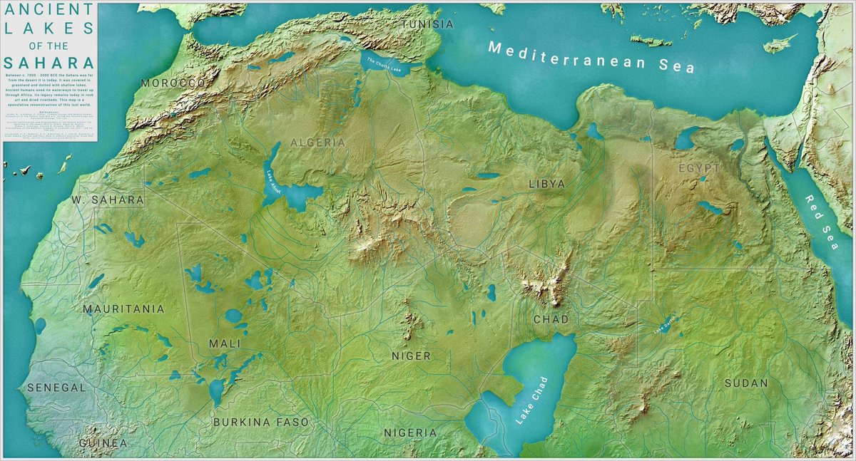
This era is known as the African Humid Period, and it peaked between 9,000 and 6,000 years ago.
In those days, the landscape of the Sahara would have supported rolling grasslands, lakes and rivers, as well as sparse forests of trees like acacia.
In those days, the landscape of the Sahara would have supported rolling grasslands, lakes and rivers, as well as sparse forests of trees like acacia.

It was also home to Neolithic human communities.
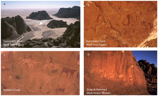
In fact, rock paintings have been found in the central Sahara that depict abundant animal life, and even people swimming, in places that are today a barren desert.
(📷 Dr. Stefan Kröpelin, Köln University)
In fact, rock paintings have been found in the central Sahara that depict abundant animal life, and even people swimming, in places that are today a barren desert.
(📷 Dr. Stefan Kröpelin, Köln University)
These communities were largely hunter-gatherers, but were increasingly beginning to practise pastoralism, ie. keeping cows and sheep.
They observed the world around them, and created incredible artworks like the so-called Dobous Giraffes (pictured).
They observed the world around them, and created incredible artworks like the so-called Dobous Giraffes (pictured).

But the days of their societies were numbered.
Changes in the earth's orbit known as its orbital precession, a change in tilt that cycles every 25,000 years, forced the African monsoon rains southward, and the Sahara became drier.
Changes in the earth's orbit known as its orbital precession, a change in tilt that cycles every 25,000 years, forced the African monsoon rains southward, and the Sahara became drier.
Trees and large plants would have died first, until only grass remained. And then even the grass would have withered and died.
Without roots to hold together the earth, the topsoil blew away, and desertification set in.
Without roots to hold together the earth, the topsoil blew away, and desertification set in.
While estimates vary wildly, some believe that this process could have taken only a few hundred years.
Human societies fled the advance of the desert, moving to the coasts. Their populations concentrated there, and they built settled societies that lived in cities.
Human societies fled the advance of the desert, moving to the coasts. Their populations concentrated there, and they built settled societies that lived in cities.

The Green Sahara reminds us of the dramatic changes that can arise from even gradual planetary shifts.
It reminds us that history is a record of change, and that things we often take for granted are not as certain as we might think.
It reminds us that history is a record of change, and that things we often take for granted are not as certain as we might think.
I talk more about the Green Sahara and its legacy in the latest episode of Fall of Civilizations.
Find it here, or on any major podcasting platform:
Spotify: open.spotify.com/episode/7EXVuI…
YouTube:
Stitcher: stitcher.com/s?eid=63547032…
Find it here, or on any major podcasting platform:
Spotify: open.spotify.com/episode/7EXVuI…
YouTube:
Stitcher: stitcher.com/s?eid=63547032…
Thanks for listening!
If you like my work and want to support the podcast, you can also contribute here. patreon.com/fallofciviliza…
If you like my work and want to support the podcast, you can also contribute here. patreon.com/fallofciviliza…
• • •
Missing some Tweet in this thread? You can try to
force a refresh