Bill Hayton Profile picture
Jan 8, 2020 18 tweets 9 min read Read on X
A thread about the historical explanation for Indonesia’s current stand-off with China in the South China Sea. Image
The dispute is over who has the right to fish in an area of sea off the Natuna islands. The area is defined by an overlap of China’s ‘U-shaped line’ with Indonesia’s Exclusive Economic Zone drawn from Natuna. Image
Indonesia’s EEZ is claimed in line with the UN Convention on the Law of the Sea (UNCLOS). Indonesia has the rights to the resources up to 200 nautical miles from inhabited territory. But where does China’s ‘U-shaped line’ come from? (Map: @madeandi ) Image
@madeandi China’s ‘U-shaped line’ was first published by the government of the Republic of China in early 1948. Discussions about how to draw the line began after the Second World War. @Chris_PC_Chung has told the story here journals.sagepub.com/doi/abs/10.117… Image
@madeandi @Chris_PC_Chung Two key figures, employed by the Republic of China Ministry of Interior to advise it on the post-war territorial claims, were geographers: Zheng Ziyue 鄭資約 and Fu Jiaojin 傅角今 Image
@madeandi @Chris_PC_Chung These two men drew the first version of the U-shaped line – a ‘sketch map’ presented to an ROC inter-ministry meeting on 25 September 1946 Image
@madeandi @Chris_PC_Chung But where did this line come from? Both Zheng Ziyue and Fu Jiaojin were students of a self-taught Geography professor Bai Meichu at Beijing Normal University in the late 1920s. They copied a line he had drawn in 1936. Image
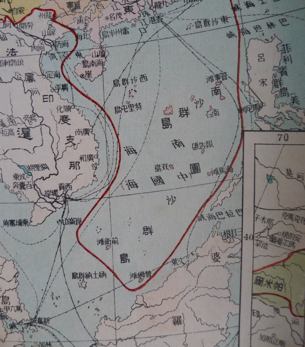
Bai Meichu had published his ‘New Atlas of China’s Construction’ 中華建設新 圖 in 1936 in which he asserted claims to China’s modern territory – which was in dispute in many areas. He drew a bold red line around his idea of China’s rightful boundary. Image
But Bai didn’t know much about the South China Sea. His map is full of non-existent islands – around which he drew his red boundary line. They included Vanguard Bank off Vietnam, James Shoal off Borneo and Seahorse Shoal off the Philippines. Image
The Chinese names for all these features were simply translations or transliterations of the English names: Vanguard Bank = Qianwei Tan; James Shoal = Zengmu Tan; Seahorse Shoal = Haima Tan. Image
Bai took these names from a list of translations made by an RoC government committee in 1934. The committee chose to translate the English words ‘bank’ and ‘shoal’ with the ambiguous Chinese character ‘tan’ 灘 which means ‘sandbank’. Image
Bai seems to have assumed that all these ‘tans’ were above-water islands and drew his red line around them. But all were, in fact, underwater features. This is why China now claims non-existent islands as its territory. [Picture shows a PLAN oath-taking ceremony at James Shoal] Image
Why did the RoC Committee choose that list of island names? They simply copied it from the UK Hydrographic Office China Sea Directory of 1906! Image
They also seem to have relied on a map published by the London company @StanfordsTravel in 1918. [Compare the 1918 map with the RoC 1948 map below] Image
@StanfordsTravel The line that Bai Meichu drew around Seahorse Shoal, James Shoal and Vanguard Bank in 1936 was based on underwater features drawn on the Stanford’s map of 1918 Image
@StanfordsTravel This line was taken up by his students, Zheng and Fu, and passed on to the ROC government in 1946. This is the line which is now causing problems for the whole region, including Indonesia. Image
@StanfordsTravel So, ridiculous as it sounds, Indonesia’s current problems with China in the South China Sea are the results of poor translation and bad map-making in China in the 1930s. Beijing’s claim is based on ignorance.
I tell the full story in my article for Modern China here journals.sagepub.com/doi/abs/10.117…

I will also flesh out some of the characters involved, in my next book for @yalepress ‘The Invention of China’ due to be published in September.

END OF THREAD!

• • •

Missing some Tweet in this thread? You can try to force a refresh
 

Keep Current with Bill Hayton

Bill Hayton Profile picture

Stay in touch and get notified when new unrolls are available from this author!

Read all threads

This Thread may be Removed Anytime!

PDF

Twitter may remove this content at anytime! Save it as PDF for later use!

Try unrolling a thread yourself!

how to unroll video
  1. Follow @ThreadReaderApp to mention us!

  2. From a Twitter thread mention us with a keyword "unroll"
@threadreaderapp unroll

Practice here first or read more on our help page!

More from @bill_hayton

Aug 24, 2023
@NBRnews asked me for some thoughts on 'Conceptions of Strategic Space in Republican China' for their latest project. This is what I pulled together... (It's based upon the work of many others.) 🧵 strategicspace.nbr.org/conceptions-of…
2/n The overall theme is that from 1912-1949, the Chinese state controlled only a fraction of the territory that it claimed. Strategic thinking was therefore focused on areas within its putative borders rather than beyond them. Image
3/n But there was a deeper problem. The leaders of the new Chinese state didn't know where the country's actual borders were! This was partly about mapping but more fundamentally about how to define a 'Chinese' state. Were the 'non-Han' areas a part of China or not?
Read 17 tweets
Jan 15, 2023
Lots of rumours that #Vietnam’s President Nguyen Xuan Phuc is politically phucd. If true, unprecedented in recent decades. General-Secretary Trong breaking all precedents to clear out those his gang regards as insufficiently hard-line
Changes at the top in Vietnamese politics look almost like an internal coup. Competent government officials - Phuc, Binh Minh & Dam defenestrated, the Ministry of Public Security taking over...
Behold the man rumoured to be the next president of Vietnam - current Minister of Public Security To Lam. Amazing that a man who can eat gold-plated steak can survive the fiery furnace of the anti-corruption campaign
Read 4 tweets
Jan 7, 2023
Looks like this phase of the Vietnam mega-corruption scandal will end with the ‘performance legitimacy’ team losing out to the ‘regime security first’ team. Ailing General-secretary Trong trying to secure his Leninist legacy… open.substack.com/pub/asiasentin…
Add to this the arrests of two people thought to be relatives of the wife of President Nguyen Xuan Phuc and the picture becomes even more stark
Arrest of Trần Văn Tân, deputy chairman of Quang Nam province, thought to be nephew of wife of President Nguyen Xuan Phuc dangcongsan.vn/phap-luat/khoi…
Read 6 tweets
Jan 13, 2022
Looking forward to reading this! First, a point of caution to breathless reporters - this is about MARITIME claims, not TERRITORIAL claims.
It judges Chinese claims against UNCLOS - the UN Convention on the Law of the Sea - which China ratified in 1996. It finds four types of Chinese claims that are 'unlawful' - ie incompatible with UNCLOS
1. Sovereignty claims to reefs and other features that lie entirely underwater.
2. Drawing straight baselines around very spread-out groups of islands
3. Claiming to own everything within those baselines
4. Unspecified 'historic rights' that go beyond UNCLOS
Read 22 tweets
Jan 10, 2022
More nonsense history of the South China Sea published by the South China Morning Post - this time written by the CEO of a private equity firm. I guess this is what corporate bosses have to do to gain favour from Beijing these days. Anyway, rebuttal...
scmp.com/week-asia/opin…
"until recently, the US had not disputed or objected to China’s claims"
The US is neutral on the TERRITORIAL claims of all sides. It (& many other states) is not neutral on the unlawful MARITIME claims of the various sides. If you don't understand this, don't write the article
"China’s Nationalist government, under Chiang Kai-shek, used US supplied warships to recover several major islands in the South China Sea from Japan"
No islands were 'recovered' from Japan. Japanese forces had all departed in 1945. Chinese forces didn't land until December 1946
Read 24 tweets
Dec 2, 2020
Just been sent a fascinating US Govt telegram shedding light on Washington's attitude to territorial claims in the South China Sea during the 1956 episode that really restarted the whole contest. (I haven't seen the original piece of paper, just a scan.) Thread...
2. This was triggered by the Philippine entrepreneur Tomas Cloma who, in 1956, claimed most of the Spratly Islands for himself as his own personal country called 'Freedomland'. This upset everyone else - both Chinas, Vietnam and even his own government (story is in my SCS book)
In response, the Republic of China (Taiwan) government sent some navy ships to evict Cloma's brother and supporters from the huts they had erected on Itu Aba (Taiping Island) and some other features. They forced Cloma's brother to sign a paper saying he wouldn't come back.
Read 10 tweets

Did Thread Reader help you today?

Support us! We are indie developers!


This site is made by just two indie developers on a laptop doing marketing, support and development! Read more about the story.

Become a Premium Member ($3/month or $30/year) and get exclusive features!

Become Premium

Don't want to be a Premium member but still want to support us?

Make a small donation by buying us coffee ($5) or help with server cost ($10)

Donate via Paypal

Or Donate anonymously using crypto!

Ethereum

0xfe58350B80634f60Fa6Dc149a72b4DFbc17D341E copy

Bitcoin

3ATGMxNzCUFzxpMCHL5sWSt4DVtS8UqXpi copy

Thank you for your support!

Follow Us!

:(