My Authors
Read all threads
It's taken six years since my book came out, but finally a response from some Chinese researchers. Let's see what they have to say...
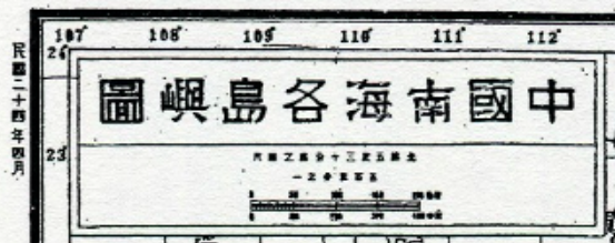
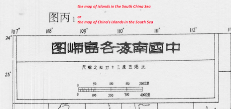
The first point is one of translation. @Zhengyimingdao states that the title of the 1934 map "中国南海各岛屿图" is "Map of the South China Sea Islands of China". I think that's wrong. It's ambiguous but I believe a better translation is simply "Map of the South China Sea Islands"
2. Contrary to what @Zhengyimingdao asserts, there is no indication whatsoever on this map of any territorial claim by any country - including the Republic of China.
He also states that the map "clearly marked China’s territorial boundary in the South China Sea". But there are no maritime territorial boundaries marked on the map...
The author notes that the map includes the "Nansha Islands (now the Zhongsha Islands)" - but without comment. The Zhongsha 'Islands' (they aren't actually islands but we'll let that pass for now) refers to the Macclesfield Bank in the centre of the South China Sea.
In 1934 the RoC committee gave the Macclesfield Bank the name 'Nansha' or 'southern sands'. This was because it was to the south of China's then territorial claim. Only in 1947 did the RoC change the name to 'Zhongsha' - 'central sands' - because China's claim had moved south
In 1947, the Chinese name 'Nansha' was moved south to become the Chinese name for the Spratlys. This was because the claim itself had moved south.
The author argues that because the map-makers marked the Philippines as 'USA', Vietnam as 'France' and Borneo as 'Britain' but gave no indication of the sovereignty of the islands in the middle of the sea, their intention can only have been that they regarded them as Chinese
This seems to be simply wishful thinking. We know from other RoC documents from the same period that the Chinese government regarded Triton Island in the Paracels as the southernmost point of its claim in the South China Sea.
I'm pleased that the author agrees with me that "It is true that the Map of the South China Sea Islands of China borrowed some information from British maps." However, it would be more accurate to state that the map was directly copied from British maps.
The author states "From the sovereign intention perspective, the map asserted China’s state will..." I disagree entirely. What did it assert? There is no claim marked on the map. The map was drawn to inform officials precisely because they knew so little about the South China Sea
The author quotes Li Guoqiang as claiming this map was the “first official map of the South China Sea publicly released by the Government of the Republic of China.” But was it publicly released? I think it was only ever used for internal purposes. (But I could be wrong on this.)
If it was not publicly released then the author's subsequent argument about whether other countries 'acquiesced' to its publication has to be moot.
In short, the author's argument rests on a single assertion - that the title of the map represents a territorial claim on the islands of the South China Sea. But has he faithfully translated the title? I don't think so.
The author references the records of the RoC 'Land and Water Maps Inspection Committee (水陆地图审查委员会会刊) but can find nothing in them to support his assertion that the map represented a territorial claim. If that really was the committee's intention - show us the quote!
Instead I'll offer an official Republic of China document that demonstrates that as late as 1943, the RoC only claimed the Paracels - and nothing further south.
Suffice to say, I remain confident of the narrative I put forward in my 2018 article. But I know that @Chris_PC_Chung and others will have plenty more to say soon... journals.sagepub.com/doi/abs/10.117…
An odd thing. The map that @Zhengyimingdao attaches to his article is different from my copy of the 1935 map. And the titles are different. This requires a little more investigation...
Here's my (slightly annotated) copy.
Missing some Tweet in this thread? You can try to force a refresh.

Keep Current with Bill Hayton

Profile picture

Stay in touch and get notified when new unrolls are available from this author!

Read all threads

This Thread may be Removed Anytime!

Twitter may remove this content at anytime, convert it as a PDF, save and print for later use!

Try unrolling a thread yourself!

how to unroll video

1) Follow Thread Reader App on Twitter so you can easily mention us!

2) Go to a Twitter thread (series of Tweets by the same owner) and mention us with a keyword "unroll" @threadreaderapp unroll

You can practice here first or read more on our help page!

Follow Us on Twitter!

Did Thread Reader help you today?

Support us! We are indie developers!


This site is made by just two indie developers on a laptop doing marketing, support and development! Read more about the story.

Become a Premium Member ($3.00/month or $30.00/year) and get exclusive features!

Become Premium

Too expensive? Make a small donation by buying us coffee ($5) or help with server cost ($10)

Donate via Paypal Become our Patreon

Thank you for your support!