
I've had some time to digest the recently-released Leicester City Street Design Guide, thread 1/: #leicester #cycleinfra #streets leicester.gov.uk/media/186708/l…
Streets are often our first interaction with the built environment, its what you step out into when you leave your building. Streets can make or break a nice place to live, and form many functions - providing some open space, allowing transport, and carrying utilities to homes 2/
Thanks to various planning changes and desperate developers, many modern streets are flawed - being uninviting for users, difficult to navigate especially for the more vulnerable, failing to promote active travel or a healthy lifestyle, and with high maintenance costs 3/
Most cities are now taking a greater lead in the planning, design & maintenance of streets, recognising that change is needed. Leicester's Design Guide is a welcome step forwards, taking best practice from other authorities and documents eg Manual for Streets 4/
Common problems with streets include: high vehicle speeds, poor pedestrian/cycle links, poor access for other users e.g. wheelchair/pushchairs, bin lorries/fire engines, no greenery, encouraging crime, rabbit-warren cul-de-sacs. Check out @PlanningShit for plenty of examples 5/
Here is a local development in the county. Red arrows are where I'd expect to see ped/cycle links into the estate. Green arrow is where the access actually is. This increasing walking distances & times, encouraging car use instead of public transport or active travel 6/ 

The estate does have some positives: there's a reasonable amount of green space combined with drainage features, and not too much overlook/crampness of buildings - but it's a delicate trade-off to avoid inefficient use of precious habitable space 7/


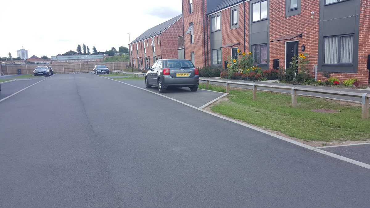
Change of surface encourages slower speeds, kerbs retained to demarcate footway/carriageway, blocks have gaps between to allow direct rainwater infiltration instead of going into drains and overloading watercourses. 8/


However level or "semi-shared" surfaces sometimes encourage footway parking. This is Abbey Mills in Leics city, the footways are wide and level meaning they're parked over despite separate car parks being provided. 9/


Elsewhere is Abbey Mills there's a nice drainage swale separating carriageway, parking & footway. But odd patches of grass with no protection get parked on/overran and turn into dust bowls. A small hedge or tree would be better use of these areas to discourage parking 10/

Another street in Abbey Mills; despite the flush kerbline the car is still parked over the footway. Asphalt "service strip" on the right is pointless and doesn't serve as a footway, would look better integrated with the rest of the street. 11/

Parking is one of the biggest problems; this estate in Nuneaton is 5 mins from the M6 with no public transport. Off-road parking provided on the right but houses on left park their 2 cars on the street. Result is a clogged road which cars speed down causing fumes 12/

New Lubbesthorpe, Leicester Forest East. Frontal offroad parking provided but large vehicles such as vans overhang the footways, and on the right a car fully blocking the footway, which is barely wide enough. You could walk in the road but its uninviting with so many vehicles 13/

Separate parking often in enclosed courts & lots of brick walls as developers think people like them, but often these aren't overlooked and encourage crime by offering plenty of hiding spots. We should be designing out crime, we already do it with subways (by removing them) 14/


Pic 1, Mallard Close in Aylestone, a car-park canyon. Pic 2, Chelmer Village in Chelmsford unusually quiet when GSV passed, a narrow brick valley with tiny token greenery, no parking, no footway, the hardstandings usually parked with cars blocking the house front doors 15/


So without quote-tweeting the entire document, the Streets Design Guide is fairly clear on addressing all of these issues, recognising the need to create a sense of place & purpose, embrace the city's heritage and futureproof for generations 16/
It includes providing cycle parking, street art, equal-access needs, drainage, utility/emergency vehicle access, heritage, change of use, & economic impacts. Fairly impressive is the acknowledgement that health benefits need to be included in economic assessments for new schemes
Also included are design element & principles & notes which contain greater details of certain elements. e.g junctions show examples of Dutch rbts and CYCLOPS jcts. Lots of nods to TfL, TfGM, Waltham Forest, Cambridge etc bringing together best practice from all of UK 18/
My biggest criticism is it's not prescriptive enough. There's lot's of "shall" & "should", to allow flexibility I assume, but give unscrupulous planners an inch and they'll take a mile. Better to mandate solutions, then allow dispensations, to ensure standards are enforced 19/
Early on there's a nice "Street Typology" chart - it would've been nice to see real-life Leicester examples of each classification to better understand what they consider a "Neighbourhood Connector" e.g Fosse Road? 20/

The Design Sheets do contain some good principles e.g at driveway footway crossings at least 900mm of the footway should remain at normal footway level & not fully ramped - remains to be seen if this will be enforced! Not done in this example from Bede Island on right 21/

Here's some good real-life examples from Ashton Green, Leics flagship new development. SUDS ponds for drainage with walking paths providing greenery, plenty of frontal off-road parking means road is clear & feels inviting for NMU use due to shared surface, bend for slow speed 22/


There's a very subtle paving change to denote some kind of footway but I doubt this would be picked up by visually-impaired users..or drivers for that matter. Pic 2 has a bit more hard landscape with builtouts w/trees for parking (note sloping footways at crossings again) 23/


I felt fine cycling around Deacon Rd but when reaching the main road there was no cycle provision or signage - Ashton Green Rd is a connector and should have some separate cycle provision, needs including from day 1 of development - otherwise how do we discourage car use? 24/

Pic 1 & 2 better examples from Leics with more open streets & cars away from footways. Pic 3 &4 from county, Pic 4 has a pointless 'service strip' but SuDS ponds on the right reducing some overlook & providing green amenity. 25/


Leics do say they expect to revise this 1st edition very quickly, within 18 months to reflect feedback & new developments. I haven't included in this thread but most of city centre streets look fantastic compared to 10yrs ago(see my other threads) 26/
For now, I hope this is applied strongly with developers and retrofitted to existing streets within the city. Hopefully see some of this guidance in the wild within a few years, as always with my tweets just need the county to catch up! END/

