Dr Jarrah Sastrawan Profile picture
Sep 13, 2020 11 tweets 4 min read Read on X
People of the Indo-Malay archipelago made maps of land and sea at least as far back as the 13th c. Unlike medieval European maps, none of these early indigenous maps survived, but we know they existed because foreigners wrote about them and probably copied them Image
The Yuan official history mentions that in 1293, the defeated Yuan army brought back from Java "a map and census register" (地圖戶籍) of the country. I'm not sure if it says that these were given by the Javanese king himself, but historians infer so chinesenotes.com/yuanshi/yuansh…
There are no explicit mentions of maps in 14th c. indigenous sources, but the Deśavarṇana indicates that the Majapahit court actively surveyed the countryside. The court used charters and other written documents to produce what seem to be censuses:
"The prince of Wəngker sent out missions to check the districts and to describe them all, the prince of Siṁhasāri sent out missions to check the size of the clustered settlements and all their property" (Deśavarṇana 79.2) Image
These bureaucratic "descriptions of districts" may have been written texts like the Deśavarṇana itself, but it's possible that they were supplemented by visual aids. Certainly the Javanese were obsessed with geography, as journey tropes are found throughout their literature
When the Portuguese forced themselves into the archipelago, they eagerly sought local maps. In 1512 the conquistador Alfonso de Albuquerque bragged to his king Manuel I of an extraordinary Javanese map that he said included even Portugal and Brazil: scielo.br/pdf/hcsm/v2n3/… ImageImage
If the Javanese map lost in the Frol de la Mar wreck had survived (and if Albuquerque's description was accurate), it would probably be world-famous today. It goes to show how the near-total loss of indigenous sources has seriously impoverished our knowledge of its history
Since the original is lost, there's controversy over whether the map's depiction of the western hemisphere reflects Javanese knowledge or Portuguese influence. But I think the Javanese could easily have incorporated European cartographic knowledge into their own maps by this time
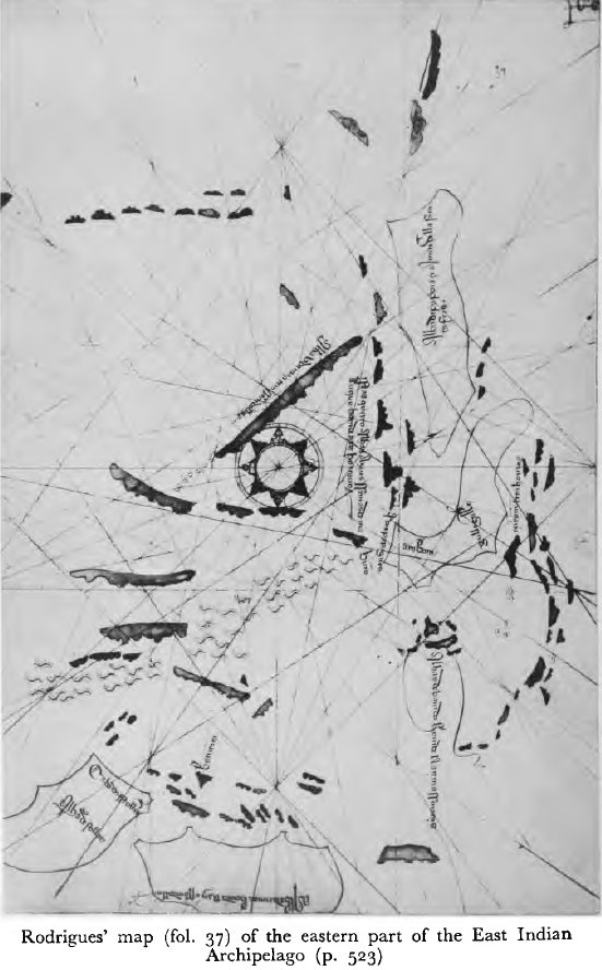
Francisco Rodrigues was a cartographer attached to the 1512 Portuguese expedition to Maluku led by Antonio de Abreu. He drew a series of maps, either drawing on or directly copying from indigenous maps, which he collected in his own handwritten book jstor.org/stable/27864629
Rodrigues' book contains a copy of the very important Suma Oriental by Tome Pires (written ca. 1513), who also made use of non-European maps. In his report on south Maluku, he is ambivalent about the accuracy of maps made by the "Moors" (i.e. by Muslims, either local or foreign) ImageImage

• • •

Missing some Tweet in this thread? You can try to force a refresh
 

Keep Current with Dr Jarrah Sastrawan

Dr Jarrah Sastrawan Profile picture

Stay in touch and get notified when new unrolls are available from this author!

Read all threads

This Thread may be Removed Anytime!

PDF

Twitter may remove this content at anytime! Save it as PDF for later use!

Try unrolling a thread yourself!

how to unroll video
  1. Follow @ThreadReaderApp to mention us!

  2. From a Twitter thread mention us with a keyword "unroll"
@threadreaderapp unroll

Practice here first or read more on our help page!

More from @infiniteteeth

Dec 3, 2021
A fantastic new paper by Abimardha Kurniawan that finally deciphers the mysterious Javanese dating system called 'sakala dihyang'. This practice, which disguises year numerals in multiple layers of encoding, was particularly common in the mountains of Java
ejournal.perpusnas.go.id/jm/article/dow…
The Javanese loved chronograms, which are systems for encoding numbers (especially years) in symbolic forms. The sakala dihyang represents perhaps the most complex of these systems, not properly understood until now newmandala.org/the-art-of-dat…
A well-known type of chronogram are called 'sakala milir', where the year is encoded as a sequence of four words, often in reverse. This goes back to the bhūtasaṁkhya system of Sanskrit verse. Here the Javanese year 1589 (1666–7 CE) is encoded as 'wani marga brahmaṇa sanga'
Read 6 tweets
Jul 7, 2021
Another fascinating growth area in recent years is the early history of northern Sumatra. New philological and archaeological work has improved and often challenged our understanding of 13th–15th century polities like Lamri and Pasai, and the communities around them
Guillot & Kalus' 2008 edition and translation of a large corpus of Pasai funerary inscriptions opened up new interpretations of the Pasai Sultanate's history, including evidence of a Turkic-descended royal dynasty in the late 14th century worldcat.org/title/monument…
A key source of Pasai history is the Hikayat Raja Pasai. The late Russell Jones published a new edition using a recently-discovered second manuscript (1999) and a new English translation (2013) – these are the best versions to read
worldcat.org/title/hikayat-…

worldcat.org/title/pasai-ch…
Read 6 tweets
Sep 13, 2020
Ludovico di Varthema, an Italian visitor, chartered a ship from Borneo to Java in 1505. The captain, who was almost certainly Indonesian, used a "compass with a magnet" and "a chart all marked with lines, perpendicular and across". The whole passage is worth reading:
The English translation is by John Winter Jones (1863, pp. 248-251), and this Italian edition was published in Venice in 1535 (ff. 70r-v), digitised by the Bayerische Staatsbibliothek: reader.digitale-sammlungen.de/en/fs1/object/… ImageImageImage
How should we interpret "vna charta laqual era tutta rigata per longo & per trauerfo"? Dd the map have grid lines indicating latitude and longitude, or rhumb lines indicating constant bearing, or "lines indicating the winds" (Sollewijn Gelpke 1995: 76)?
Read 4 tweets
Sep 5, 2020
Another parallel between Old English and Javanese poetry is the toponym list genre. The English poem Widsith (7-10th c) describes a journey in mid-1st millennium Europe with lists of places and peoples. The Javanese Desavarnana and Sundanese Bujangga Manik (14-15th) do the same
Widsith focusses on the names of tribes and their leaders, repeating the formula "mid X ic wæs ond mid Y". One can read this as a sort of ethnic map of Europe, sketched out by the poet's travels phil-fak.uni-duesseldorf.de/fileadmin/Reda… Image
The Deśavarnana's title means "Description of Districts". Much of its middle section is devoted to an eyewitness account of the king's journey through his kingdom in 1359. There's an abundance of toponyms that serve no plot function; instead they convey a sense of copiousness ImageImageImage
Read 8 tweets
Sep 1, 2020
I love the Old English poem "The Ruin", which describes buildings wrecked by time and imagines the people who built them. The diction makes for a really vivid scene: wrætlic ("wondrous"), undereotone ("eaten under"), eorðgrap ("earth's grip") en.wikipedia.org/wiki/The_Ruin ImageImage
This great blog post helped me, who knows no Old English, to understand just how artful the poem's construction is deorreader.wordpress.com/2019/03/31/wra…
It's interesting to compare how different poetic traditions depict ruins. The Old English poem emphasises the contrast between the ruin's desolation in the present and how it was full of life in the past. The temporal contrast comes through strongly ImageImage
Read 6 tweets
Aug 30, 2020
In terms of surviving documents, Old Malay goes back as far as Old English (7th century), and Old Javanese as far as Old French (9th century). All four vernaculars emerged out of cosmopolitan literate cultures: Sanskrit in Indonesia and Latin in Europe
The 7th century ones are religious. The Old Malay Sojomerto inscription pays homage ("samwah hiyaŋ" > Modern Indonesian "sembahyang") to Śiva and all the deities, while Cædmon's hymn in Old English praises the Christian God as the "hefaenricaes uard" (guard of heaven's realm)
The 9th century ones are political. The Old Javanese Muṇḍuan inscription records a reward of land from a lord to his follower, while the Strasbourg Oaths in Old French (plus Latin and Old High German) are pledges of loyalty between the brother-kings of East and West Francia
Read 6 tweets

Did Thread Reader help you today?

Support us! We are indie developers!


This site is made by just two indie developers on a laptop doing marketing, support and development! Read more about the story.

Become a Premium Member ($3/month or $30/year) and get exclusive features!

Become Premium

Don't want to be a Premium member but still want to support us?

Make a small donation by buying us coffee ($5) or help with server cost ($10)

Donate via Paypal

Or Donate anonymously using crypto!

Ethereum

0xfe58350B80634f60Fa6Dc149a72b4DFbc17D341E copy

Bitcoin

3ATGMxNzCUFzxpMCHL5sWSt4DVtS8UqXpi copy

Thank you for your support!

Follow Us!

:(