Dr. Lucy Jones Profile picture
Dec 13, 2020 4 tweets 2 min read Read on X
Like #DrBiden, I learned that sometimes you need to add that "Dr.". In the 1980s, I had to dress in shorts and T-shirt to show I was a geologist. Nice clothes at Caltech meant you were a secretary.
In the 1990s, all the Caltech/USGS seismologists were on TV explaining earthquakes. The women were called the "earthquake ladies". The men were called seismologists. I started using the Dr. to remind the reporters that women could be scientists too.
In the 2000s, I joined the CA Seismic Safety Commission. Using the Dr. meant quicker appointments with the legislators.

In the 2010s, that Dr. led to policy makers willing to listen to me and work together for change.

#DrBiden, I and every other PhD deserve to use our titles.
This discussion got me thinking of why I use the "Dr." and when. It's about respecting expertise, but we are having a hard time with that in the US recently. Discussing all this on my podcast.
podbean.com/eu/pb-dnue9-f5…

• • •

Missing some Tweet in this thread? You can try to force a refresh
 

Keep Current with Dr. Lucy Jones

Dr. Lucy Jones Profile picture

Stay in touch and get notified when new unrolls are available from this author!

Read all threads

This Thread may be Removed Anytime!

PDF

Twitter may remove this content at anytime! Save it as PDF for later use!

Try unrolling a thread yourself!

how to unroll video
  1. Follow @ThreadReaderApp to mention us!

  2. From a Twitter thread mention us with a keyword "unroll"
@threadreaderapp unroll

Practice here first or read more on our help page!

More from @DrLucyJones

Jul 29, 2021
The M8.2 Alaska quake is on the subduction zone interface. That means the seafloor under the Pacific Ocean is being pushed under the Alaskan peninsula. It also means it generated a tsunami.
earthquake.usgs.gov/earthquakes/ev…
@NOAA Tsunami Warning System has issued a tsunami watch for the West Coast. The warning for Hawaii has been cancelled, because the waves are focused east of Hawaii and the event isn't that large. @NWS_NTWC
This location is not a surprise. I led a @USGS project to model a bad tsunami for Los Angeles and we put the model location at the same place. It is just west of the 1964 quake and historically hadn't had much activity. But our modeled quake was bigger pubs.er.usgs.gov/publication/of…
Read 4 tweets
Jan 17, 2021
27 years since the Northridge earthquake. Shaken awake at 4:30, I jumped up to go to work. My 7 yr old panicked - he had learned with the Landers quake that Mommy could be at work for days. So I took him with me & he mapped cracks in the office walls. Now he's in nuclear physics
Northridge quake: our old computers couldn't keep up. The algorithm to screen out analog noise bursts in the data misidentified the quake as noise and blocked the data. So much data was coming in from aftershocks, we couldn't get the bandwidth to release the mainshock for 3 hrs
Northridge quake: My seismologist husband was in Boston and furious to miss the quake. Flying home, he was the only one with time to think. He would call from the phone in the airplane seat back with ideas of how to improve our data collection for the aftershock sequence.
Read 5 tweets
Mar 3, 2020
We are all dealing with the impact of the Corona virus and I though I’d share how, as a scientist, I think about the risk and my actions in response. First, I try to stay with the data. As data comes in, answers will change. That’s good science. 1/5
2/5 I’m watching the mortality rate - how likely are you to die if you get sick? Flu kills 1 in 1000. Current corona estimate is 1 in 50. This may really be lower because mildly sick people are not being tested. But right now, the rate looks worse than flu.
3/5 I’m watching the transmission rate: Still unknown and it depends on management. Quarantines are trying to lower this number. It looks higher than flu because no vaccine/no history = no one has immunity. It looks likely that community transmission will spread.
Read 5 tweets
Jan 28, 2020
A tsunami primer (1 of 6):
Tsunamis begin when the shape of the seafloor changes suddenly. The water above the changed seafloor is pushed up, but then because it is a fluid, immediately falls down to both sides, creating the wave that moves towards shore
2 of 6: Tsunamis get taller when they approach shore. The whole column of seawater above a fault is moved, so there is a lot of water & energy in the wave, more if the sea is deeper at the source. As it approaches shore & depth of sea decreases, the height of the wave increases.
3 of 6: The 2 main causes of tsunamis are quakes on faults that push up seafloor & landslides. How big a tsunami is = how much water is displaced = how much seafloor moves up by how much. Only the biggest quakes (M≥8.5) move enough water to create a tsunami that crosses ocean
Read 6 tweets
Dec 3, 2018
Now building codes.
A building is built to withstand some shaking - not some magnitude. Any building can withstand a M8 if it is far enough away.
The code says that a building should not collapse in the worst shaking that has a 10% chance of happening in 50 years. 1/4
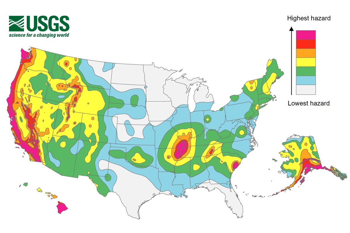
There is not one standard for all of California. At every location, @USGS calculates what is the expected shaking from known faults and a new building is built for that. A building in San Bernardino has to be stronger than a building in Orange County. 2/4
The building code doesn't try to prevent damage. It just says the building shouldn't kill people. Building "to code" means the weakest building that will not collapse in the pretty bad quake. It gives us disposable buildings. 3/4
Read 4 tweets
Dec 3, 2018
I'm seeing lots of confusion between earthquake magnitude, shaking and damage. Here's a simple outline:
Earthquakes happen because of slip across a fault that produces shaking as one of its effects. The total energy released is the magnitude. One number per quake. 1/7
Every point on the quake's fault produces energy, so the bigger the fault, the bigger the quake. Magnitude depends on the fault length, width, and the amount of slip. Both width and slip tend to scale with length, so you can guess the length of the fault from the magnitude. 2/7
The fault starts to move at a hypocenter and then moves down the fault at ~3 km/sec. A 3 km fault (M~5) breaks in 1 sec. A 300 km fault (~M8) takes 100 sec to break. So the duration of the quake depends on magnitude. Bigger quakes last longer and affect a larger area. 3/7
Read 7 tweets

Did Thread Reader help you today?

Support us! We are indie developers!


This site is made by just two indie developers on a laptop doing marketing, support and development! Read more about the story.

Become a Premium Member ($3/month or $30/year) and get exclusive features!

Become Premium

Don't want to be a Premium member but still want to support us?

Make a small donation by buying us coffee ($5) or help with server cost ($10)

Donate via Paypal

Or Donate anonymously using crypto!

Ethereum

0xfe58350B80634f60Fa6Dc149a72b4DFbc17D341E copy

Bitcoin

3ATGMxNzCUFzxpMCHL5sWSt4DVtS8UqXpi copy

Thank you for your support!

Follow Us!

:(