#TPBscan #34
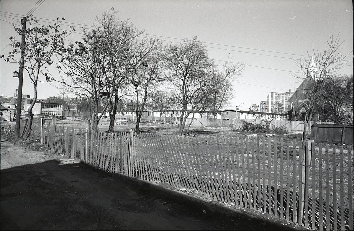
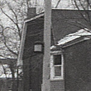
I think this may be the interior of the block in the previous photograph. Rear fences, clotheslines, parked cars, and a wreck with no wheels.
Should be able to find something like this with old aerials, but no luck so far.
I think this may be the interior of the block in the previous photograph. Rear fences, clotheslines, parked cars, and a wreck with no wheels.
Should be able to find something like this with old aerials, but no luck so far.

This mystery solved by @robintweetily!
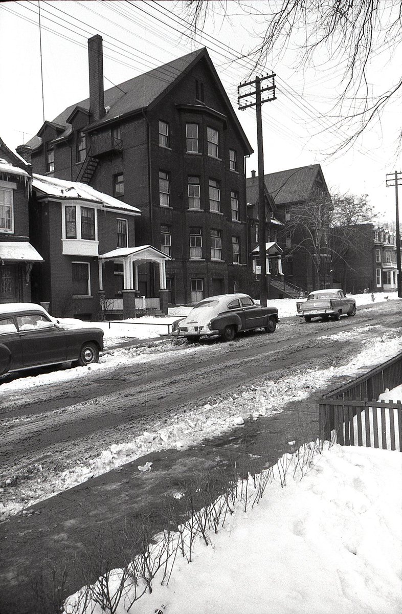
Left: the block bounded by Rhyl, Elmer, Norway, Kenilworth Avenues, the interior of which is now occupied by Beaches Lions Centennial Apartments.
Right: the north side of Norway Ave, looking west toward Elmer Ave.
Left: the block bounded by Rhyl, Elmer, Norway, Kenilworth Avenues, the interior of which is now occupied by Beaches Lions Centennial Apartments.
Right: the north side of Norway Ave, looking west toward Elmer Ave.


The old aerials even show the cars parked/abandoned in the mid-block dirt lot. ⬇️
https://twitter.com/robintweetily/status/1390424511330365443
#TPBscan #35
Wayland Avenue, looking northeast toward Gerrard. The empty lot with billboards is now occupied by Kinsmen Manor. The house on the east side of the lot still stands.
Wayland Avenue, looking northeast toward Gerrard. The empty lot with billboards is now occupied by Kinsmen Manor. The house on the east side of the lot still stands.

#TPBscan #36
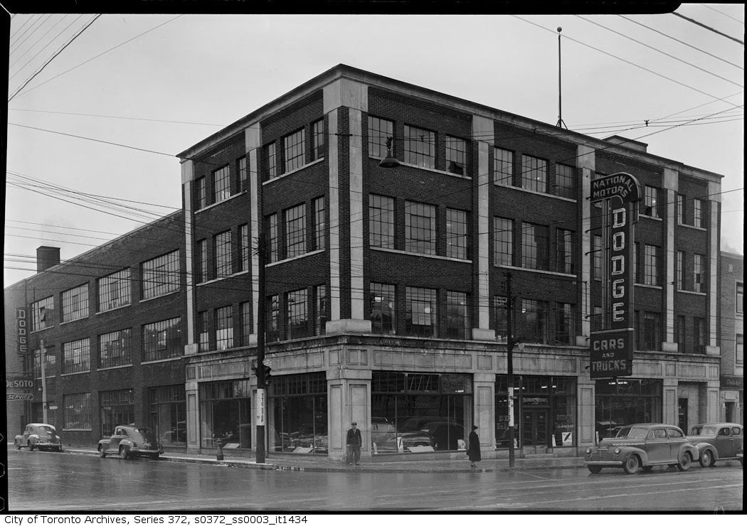
Southeast corner of Wayland and Gerrard. This view provides a look at those billboards. Dodge. B-A Tires. Cigarettes.
So many television antennas in the distance.
Southeast corner of Wayland and Gerrard. This view provides a look at those billboards. Dodge. B-A Tires. Cigarettes.
So many television antennas in the distance.

#TPBscan #37
St. George’s Macedonian Bulgarian Eastern Orthodox Church, on Regent Street, south of Dundas. Looking northeast, you can see some of Regent Park South’s low-rise housing, as well as Dickinson’s maisonette towers in the background.
St. George’s Macedonian Bulgarian Eastern Orthodox Church, on Regent Street, south of Dundas. Looking northeast, you can see some of Regent Park South’s low-rise housing, as well as Dickinson’s maisonette towers in the background.
#TPBscan #38
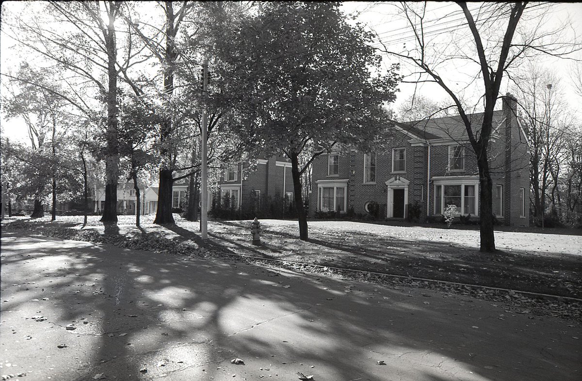
The heritage designated Sir William Gage House (1915). 49 Burnside Drive / 82 Wychwood Park. View from Burnside.
The heritage designated Sir William Gage House (1915). 49 Burnside Drive / 82 Wychwood Park. View from Burnside.

#TPBscan #39
One more shot of Sir William Gage House, looking north, up toward the Lake Iroquois shoreline. Taken from the north side of Davenport, west of Bathurst (from in or near what is now The Tollkeeper’s Park).
One more shot of Sir William Gage House, looking north, up toward the Lake Iroquois shoreline. Taken from the north side of Davenport, west of Bathurst (from in or near what is now The Tollkeeper’s Park).

Can’t easily get the same angle today...

#TPBscan #40
Smar’s Groceteria, 479 Broadview Avenue (proprietors: Michi, Stella and Adam Smeryczanski).
Smar’s Groceteria, 479 Broadview Avenue (proprietors: Michi, Stella and Adam Smeryczanski).

Current incarnation of 479 Broadview Avenue - Rooster Coffeehouse.


#TPBscan #41
Looking over Riverdale Park, toward the Prince Edward Viaduct, from the west side of Broadview Avenue, south of Withrow.
Looking over Riverdale Park, toward the Prince Edward Viaduct, from the west side of Broadview Avenue, south of Withrow.

#TPBscan #42
Looking northeast, a nice view of 146 Crescent Road, at Mount Pleasant. Mooredale House Community Centre. Another heritage property: Baillie House, 1902, Sprott & Rolph.
The bridge has changed over the years. This one had a centre pier with an art deco feel to it.
Looking northeast, a nice view of 146 Crescent Road, at Mount Pleasant. Mooredale House Community Centre. Another heritage property: Baillie House, 1902, Sprott & Rolph.
The bridge has changed over the years. This one had a centre pier with an art deco feel to it.

#TPBscan #43
Another view of Baillie House (146 Crescent Road), looking west over the bridge crossing Mount Pleasant.
Another view of Baillie House (146 Crescent Road), looking west over the bridge crossing Mount Pleasant.

#TPBscan #44/45
A rare double feature.
Two shots from the same location: the corner of Mount Pleasant Road and Roxborough Drive, looking south on Mount Pleasant.
(I like the old taxi)
A rare double feature.
Two shots from the same location: the corner of Mount Pleasant Road and Roxborough Drive, looking south on Mount Pleasant.
(I like the old taxi)


#TPBscan #46
The street sign says ‘Darling Av.’, which means this address no longer exists.
Darling was a short n/s street, running between Ontario and Bleecker, from above Wellesley to below Howard. This all made way when St. James Town was developed (see houses on left).
The street sign says ‘Darling Av.’, which means this address no longer exists.
Darling was a short n/s street, running between Ontario and Bleecker, from above Wellesley to below Howard. This all made way when St. James Town was developed (see houses on left).
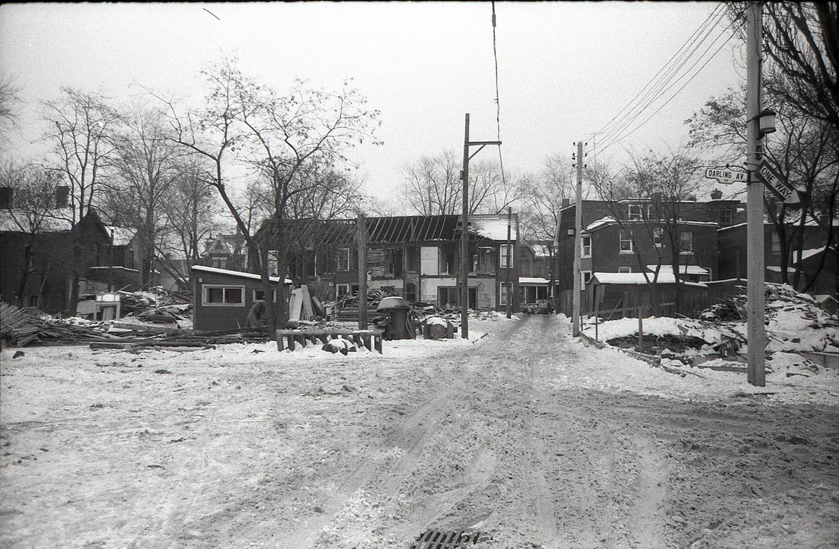
I find the old mid-pole street lamps to be an interesting detail.

#TPBscan #47
Mystery location!
If this building still exists, it would be pretty distinctive, but I can’t place it.
Yesterday’s photo was in St. James Town, tomorrow’s is the east end of Dundas.
Mystery location!
If this building still exists, it would be pretty distinctive, but I can’t place it.
Yesterday’s photo was in St. James Town, tomorrow’s is the east end of Dundas.
Mystery solved by @416expat: this is the west side of Seaton Street, north of Gerrard.
Specifically, the large building (320 Seaton) was the original Seaton House, opened in 1931 as a Depression-era shelter, and demolished in 1958 (which helps date recent pics).
Specifically, the large building (320 Seaton) was the original Seaton House, opened in 1931 as a Depression-era shelter, and demolished in 1958 (which helps date recent pics).

Also interesting: the @TorontoArchives has a photo from the same roll (I suspect they have prints of a number of these negatives):
toronto.ca/city-governmen…
toronto.ca/city-governmen…

#TPBscan #49
Summer break is over - let’s pick this up where we left off!
Still on Dundas E., this time looking east from Maughan, Kingston Road just around the bend.
Summer break is over - let’s pick this up where we left off!
Still on Dundas E., this time looking east from Maughan, Kingston Road just around the bend.

#TPBscan #50
A winter view looking southwest across Orchard Park, on the south side of Dundas Street East. Can make out some old playground equipment if you look closely.
A winter view looking southwest across Orchard Park, on the south side of Dundas Street East. Can make out some old playground equipment if you look closely.

#TPBscan #51
Standing on the north side of Dundas, looking south through Orchard Park.
There has been a fair bit of infill in this frame - townhomes and other residential where there was once parking on the south and west sides of the park.
Standing on the north side of Dundas, looking south through Orchard Park.
There has been a fair bit of infill in this frame - townhomes and other residential where there was once parking on the south and west sides of the park.

#TPBscan #52
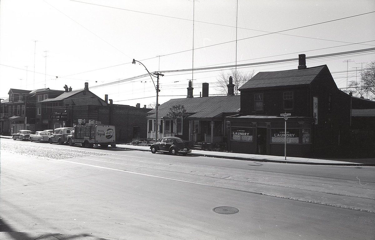
Bathurst, north of Queen. A late 1950s view of the Oak Leaf Steam Baths (closed in 2015).
Bathurst, north of Queen. A late 1950s view of the Oak Leaf Steam Baths (closed in 2015).

Same scene, then and now (2019).
I wonder if the overhanging sign still exists somewhere.
I wonder if the overhanging sign still exists somewhere.


#TPBscan #53
Another view of the Oak Leaf Steam Baths, looking southwest from Bathurst and Robinson. The old Pepsi truck is a neat detail.
Another view of the Oak Leaf Steam Baths, looking southwest from Bathurst and Robinson. The old Pepsi truck is a neat detail.
#TPBscan #54
Yonge Street, early 1960s.
A view of Rosedale Station, with 6 Crescent Road under construction immediately to the north. North Toronto Railway Station (Summerhill) clock tower visible in the distance.
Yonge Street, early 1960s.
A view of Rosedale Station, with 6 Crescent Road under construction immediately to the north. North Toronto Railway Station (Summerhill) clock tower visible in the distance.

#TPBscan #55
Another view of Rosedale Station and 6 Crescent Road from what is now Budd Sugarman Park, immediately to the south. A bus is visible in the driveway loop.
Another view of Rosedale Station and 6 Crescent Road from what is now Budd Sugarman Park, immediately to the south. A bus is visible in the driveway loop.

#TPBscan #56
Mystery location!
I haven’t yet been able to place these houses.
No sidewalks. Looks like the backyard may fall away down a slope. Two near-identical homes, side by side, with distinctive windows.
Mystery location!
I haven’t yet been able to place these houses.
No sidewalks. Looks like the backyard may fall away down a slope. Two near-identical homes, side by side, with distinctive windows.
#TPBscan #57
A few bird’s eye views before starting a new roll.
I really like this one, because the right of the frame captures a close-up of Commerce Court West under construction. You can see the progression of the curtain wall installation from top to bottom.
A few bird’s eye views before starting a new roll.
I really like this one, because the right of the frame captures a close-up of Commerce Court West under construction. You can see the progression of the curtain wall installation from top to bottom.

In the distance, a good view of Regent Park.

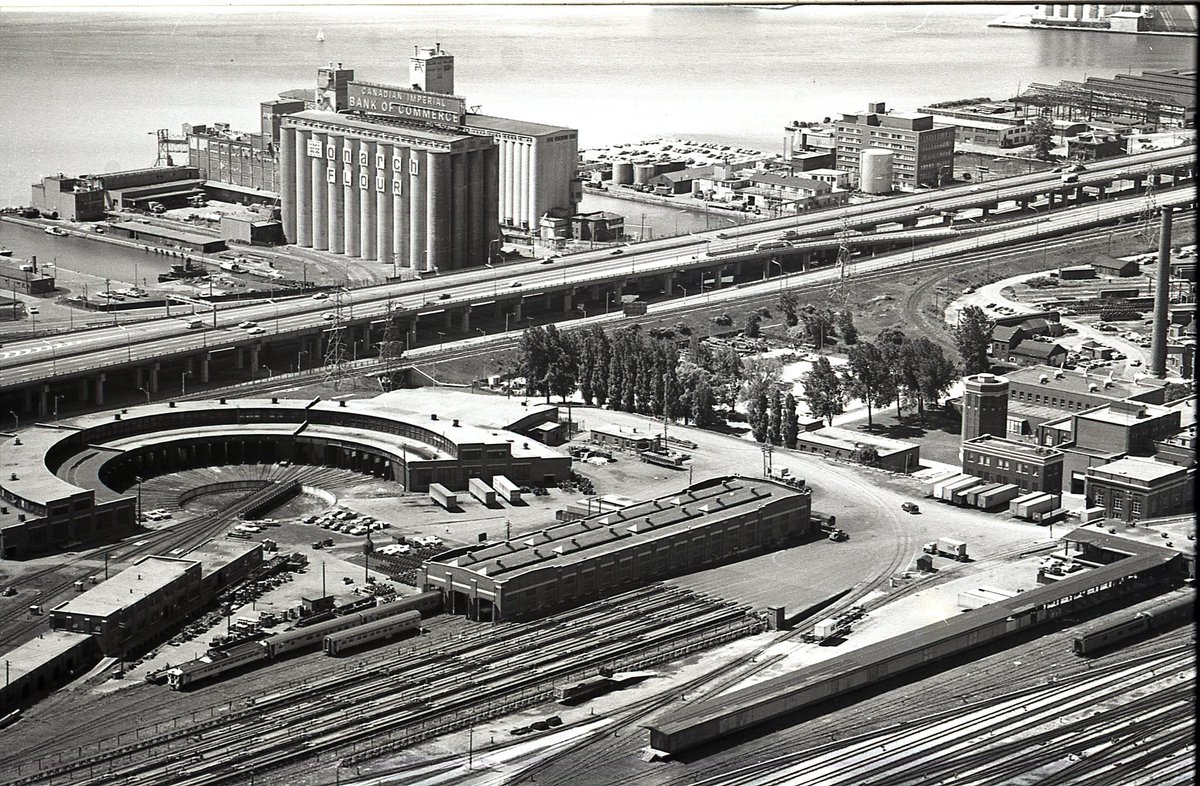
#TPBscan #58
One for the railfans.
John Street Roundhouse, late 1960s. I think those Monarch Flour silos are now HTO park.
One for the railfans.
John Street Roundhouse, late 1960s. I think those Monarch Flour silos are now HTO park.
#TPBscan #59
So much to look at in this shot - worth opening on a big screen.
The rail corridor; Fort York; Exhibition Stadium; Bulova Tower; industrial Liberty Village; pre-condo Wellington; far side of Humber Bay; the rail connection mentioned yesterday by @SwanBoatSteve.
So much to look at in this shot - worth opening on a big screen.
The rail corridor; Fort York; Exhibition Stadium; Bulova Tower; industrial Liberty Village; pre-condo Wellington; far side of Humber Bay; the rail connection mentioned yesterday by @SwanBoatSteve.

#TPBscan #60
A long NE view.
Background: Thorncliffe, Cosburn Ave. apartments.
Mid-ground: Prince Edward Viaduct, City Adult Learning Centre.
Foreground: Sears HO, Mutual Street Arena, and an under-construction RCMP building that became the Grand Hotel (demolished far too soon).
A long NE view.
Background: Thorncliffe, Cosburn Ave. apartments.
Mid-ground: Prince Edward Viaduct, City Adult Learning Centre.
Foreground: Sears HO, Mutual Street Arena, and an under-construction RCMP building that became the Grand Hotel (demolished far too soon).

#TPBscan #61
The ferry docks may have changed (this location is now Harbour Square), but we still ride the same ferries.
Also, pre-renovation Toronto Terminal Building, and the former ramp where there will soon be a new park.
No photo on Yom Kippur, but a new roll on Friday!
The ferry docks may have changed (this location is now Harbour Square), but we still ride the same ferries.
Also, pre-renovation Toronto Terminal Building, and the former ramp where there will soon be a new park.
No photo on Yom Kippur, but a new roll on Friday!

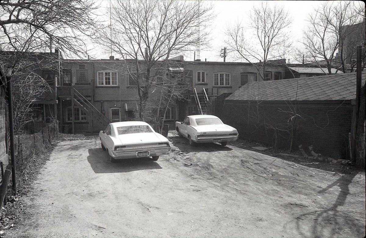
#TPBscan #62
Spring of 1969.
I believe these two cars are parked behind 3340/3342 Yonge Street (north of Fairlawn).
Spring of 1969.
I believe these two cars are parked behind 3340/3342 Yonge Street (north of Fairlawn).
#TPBscan #63
Odeon Fairlawn. West side of Yonge Street, just north of Fairlawn Avenue. Close to 2,000 seats in the theatre and balcony. Opened in 1947 and closed in 1985. On the marquee: Streisand and Sharif in ‘Funny Girl’.
Odeon Fairlawn. West side of Yonge Street, just north of Fairlawn Avenue. Close to 2,000 seats in the theatre and balcony. Opened in 1947 and closed in 1985. On the marquee: Streisand and Sharif in ‘Funny Girl’.

Same stretch of Yonge, then and now. At the end of the row, you can see where the theatre used to be.


#TPBscan #64
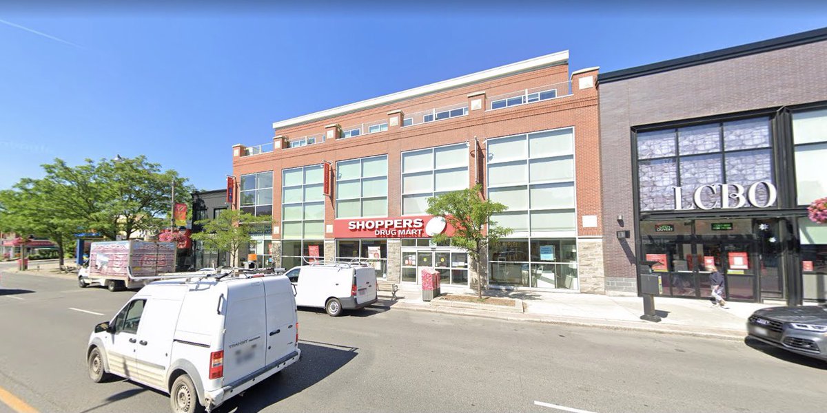
One block further north, the west side of Yonge, between St Germain Ave and Melrose Ave. Today, many of the shops on this stretch have been replaced by larger format retail (Shoppers and LCBO).
One block further north, the west side of Yonge, between St Germain Ave and Melrose Ave. Today, many of the shops on this stretch have been replaced by larger format retail (Shoppers and LCBO).

(aside: if I were to go down the ‘neighbourhood character’ path, I’d argue that the local high street was far more integral to any unique, identifiable character than whether similarly scaled structures on local side streets were houses or triplexes)

#TPBscan #65
The lane to the rear of 3358/60 Yonge Street. If you hadn’t guessed, this roll is mostly main street shops (with apartments above) and the laneways behind them.
#ThingsPlannersPhotograph
The lane to the rear of 3358/60 Yonge Street. If you hadn’t guessed, this roll is mostly main street shops (with apartments above) and the laneways behind them.
#ThingsPlannersPhotograph

#TPBscan #66
To the Danforth!
Ferriers Block, 526-536 Danforth Avenue. At the time of the photograph, still home to a namesake business, W.A.Ferrier plumbing / electrical / flooring / hardware. Now on the corner, Atlantis Restaurant (h/t @aathanasiu)
To the Danforth!
Ferriers Block, 526-536 Danforth Avenue. At the time of the photograph, still home to a namesake business, W.A.Ferrier plumbing / electrical / flooring / hardware. Now on the corner, Atlantis Restaurant (h/t @aathanasiu)

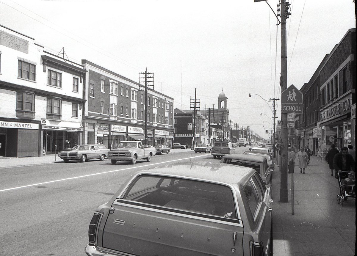
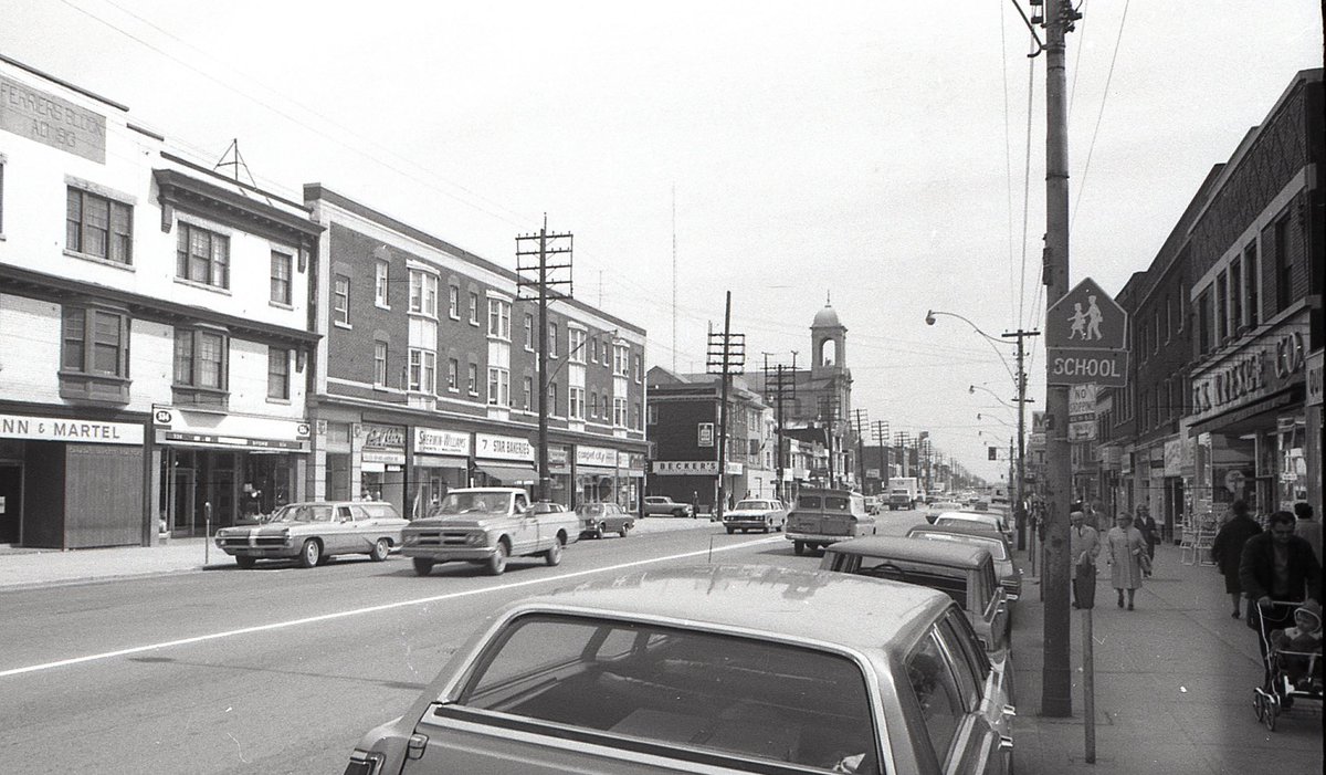
#TPBscan #67
Looking east along Danforth from Fenwick Avenue. Becker’s corner store on the left. Holy Name Church tower visible a little further down. S. S. Kresge Co. store on right, now the Fox & Fiddle. Also, station wagons!
Looking east along Danforth from Fenwick Avenue. Becker’s corner store on the left. Holy Name Church tower visible a little further down. S. S. Kresge Co. store on right, now the Fox & Fiddle. Also, station wagons!
Yesterday’s shot seemed like a good one for a then & now.
Apr 1969 / May 2021
Apr 1969 / May 2021

#TPBscan #68
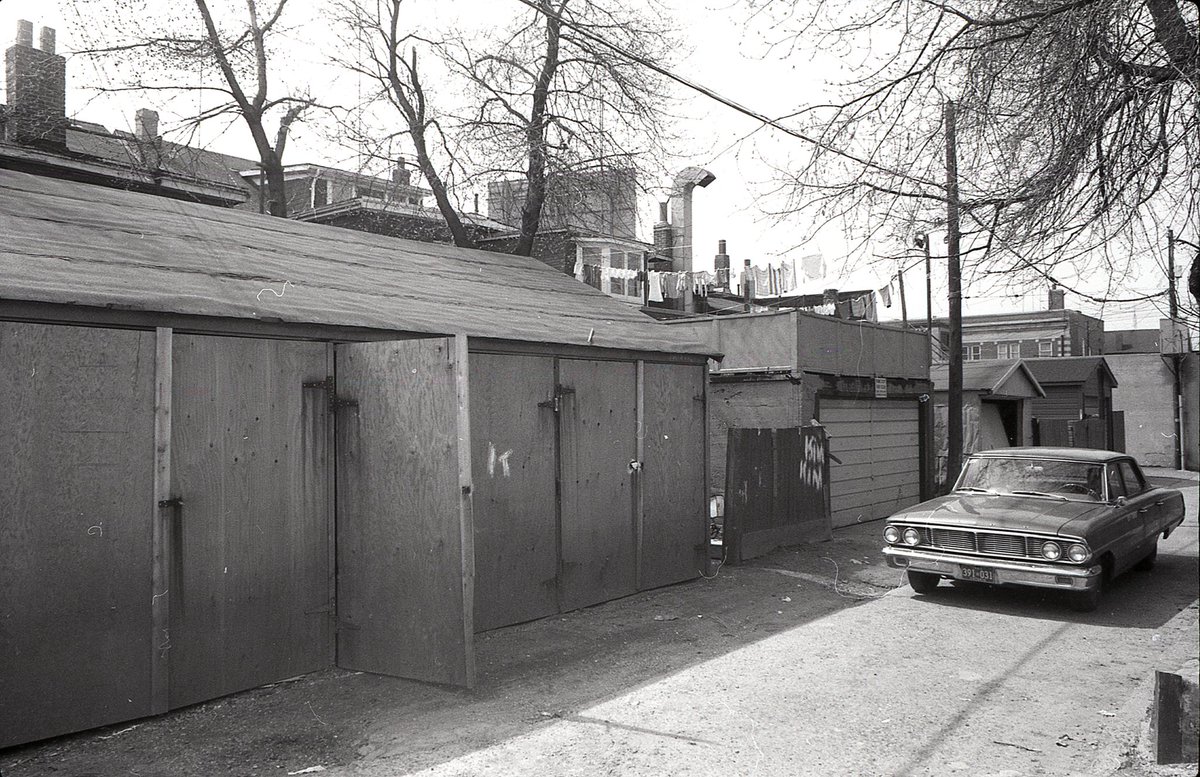
The laneway and parking behind Ferriers block (526-536 Danforth). Looking east from Ferrier Avenue.
The laneway and parking behind Ferriers block (526-536 Danforth). Looking east from Ferrier Avenue.

The length of that two-door...

#TPBscan #69
Melrose Avenue, just west of Yonge, looking north along the lane behind the main street shops. Is there somebody standing on the ledge over Smart Custom Tailor? Also, Cosentino’s Wholesale Fruit/Vegetable truck down the lane.
Melrose Avenue, just west of Yonge, looking north along the lane behind the main street shops. Is there somebody standing on the ledge over Smart Custom Tailor? Also, Cosentino’s Wholesale Fruit/Vegetable truck down the lane.

#TPBscan #70
The laneway behind 500-514 Danforth Avenue. View looking southeast - a little of the Danforth/Ferrier BMO branch peeking out towards the left.
The laneway behind 500-514 Danforth Avenue. View looking southeast - a little of the Danforth/Ferrier BMO branch peeking out towards the left.

#TPBscan #71
The laneway behind 3228-3250 Yonge (west side of the street), looking north from Cranbrooke Avenue.
(current roll is dated April 1969)
The laneway behind 3228-3250 Yonge (west side of the street), looking north from Cranbrooke Avenue.
(current roll is dated April 1969)

#TPBscan #72
Looking north from Brookdale Avenue, the laneway behind the west side of Yonge. The rear of 3284 Yonge Street in the middle of the frame.
Looking north from Brookdale Avenue, the laneway behind the west side of Yonge. The rear of 3284 Yonge Street in the middle of the frame.

#TPBscan #73
Similar to yesterday’s view, but the camera turns a little to the right and looks in a couple of the garages. The look of the late ‘60s Volvo really stands out from the North American cars of the same era.
Similar to yesterday’s view, but the camera turns a little to the right and looks in a couple of the garages. The look of the late ‘60s Volvo really stands out from the North American cars of the same era.

#TPBscan #74
Northwest corner of Danforth and Ferrier Avenue. Bank of Montreal branch in 1969, Bank of Montreal branch today.
Also, so many cross arms on those old utility poles.
Northwest corner of Danforth and Ferrier Avenue. Bank of Montreal branch in 1969, Bank of Montreal branch today.
Also, so many cross arms on those old utility poles.

#TPBscan #75
Rear laneway behind 3328-3336 Yonge Street, looking south from below St Germain Avenue. The stepped wall in the background was the north wall of the Odeon Fairlawn theatre.
(Not many laneway shots left - new roll soon)
Rear laneway behind 3328-3336 Yonge Street, looking south from below St Germain Avenue. The stepped wall in the background was the north wall of the Odeon Fairlawn theatre.
(Not many laneway shots left - new roll soon)


#TPBscan #77
Two views of the laneway behind 3180-3202 Yonge Street. Looking north from above Bedford Park Avenue, taken from the east edge of the Blessed Sacrament Catholic School property.
Two views of the laneway behind 3180-3202 Yonge Street. Looking north from above Bedford Park Avenue, taken from the east edge of the Blessed Sacrament Catholic School property.


#TPBscan #78
Behind 500 Danforth Avenue, looking west towards Logan. In the background, a little of the Danforth/Logan TD Bank branch visible over the top of the garages.
Behind 500 Danforth Avenue, looking west towards Logan. In the background, a little of the Danforth/Logan TD Bank branch visible over the top of the garages.
#TPBscan #79
New year, new roll. 1964.
The gap between the buildings is 439 University Ave (east side of the street, south of Dundas). Through the gap, you can see one of the old Eaton’s buildings demolished for the Eaton Centre (south of Terauley, enclosing Trinity Church).
New year, new roll. 1964.
The gap between the buildings is 439 University Ave (east side of the street, south of Dundas). Through the gap, you can see one of the old Eaton’s buildings demolished for the Eaton Centre (south of Terauley, enclosing Trinity Church).

Same scene, then/now.

#TPBscan #80
North side of Davenport Rd, between Bedford and Avenue, looking nw towards Bedford. Hees Geo H Co Ltd Manufacturing / Trevelyan Manufacturing. This became the TCH’s 250 Davenport property, the west half of which is now AYC condos. Another road that once had tracks.
North side of Davenport Rd, between Bedford and Avenue, looking nw towards Bedford. Hees Geo H Co Ltd Manufacturing / Trevelyan Manufacturing. This became the TCH’s 250 Davenport property, the west half of which is now AYC condos. Another road that once had tracks.

#TPBscan #81
Looking up slushy Davenport Road, past Bedford. Grimy cars. A trolley bus seems to be turning off of Bedford (not sure what route - I don’t think 6 Bay electrified until a decade later). A sign to vote George Ben for Controller (he lost to Margaret Campbell).
Looking up slushy Davenport Road, past Bedford. Grimy cars. A trolley bus seems to be turning off of Bedford (not sure what route - I don’t think 6 Bay electrified until a decade later). A sign to vote George Ben for Controller (he lost to Margaret Campbell).

Question re: the trolley bus answered by @SwanBoatSteve:
https://twitter.com/SwanBoatSteve/status/1478033891499909123
#TPBscan #82
Looking east along Davenport, towards Avenue Road. For context, if you zoom in, that metal fire escape in the distance still exists, and is on the side of the building that is now Avenue Diner (222 Davenport - then Avenue Coffee Shops)
Looking east along Davenport, towards Avenue Road. For context, if you zoom in, that metal fire escape in the distance still exists, and is on the side of the building that is now Avenue Diner (222 Davenport - then Avenue Coffee Shops)

#TPBscan #83
Mystery location!
Most of this roll is around Avenue & Davenport, but I haven’t yet been able to place this street. Biggest clue is the ‘Oldsmobile Ltd’ sign at the end of the street. There was a dealer on Avenue, north of Bloor, but doesn’t seem to fit.
Mystery location!
Most of this roll is around Avenue & Davenport, but I haven’t yet been able to place this street. Biggest clue is the ‘Oldsmobile Ltd’ sign at the end of the street. There was a dealer on Avenue, north of Bloor, but doesn’t seem to fit.

Mystery solved by @structura_!
This is Chicora Avenue, looking east toward Avenue Road.
(I should have figured this one out, as the new few shots are Pears Avenue, one block south)
This is Chicora Avenue, looking east toward Avenue Road.
(I should have figured this one out, as the new few shots are Pears Avenue, one block south)
https://twitter.com/structura_/status/1478781567094956035
#TPBscan #84
A mid-town industrial streetscape that no longer exists. Looking west along Pears Avenue, toward Bedford.
North side: Queen City Storage, McBride Motors, Dept of Citizenship & Immigration
South side: Hartline Ltd, Laminall Mfg, Collins Printing co, Hess/Trevelyan
A mid-town industrial streetscape that no longer exists. Looking west along Pears Avenue, toward Bedford.
North side: Queen City Storage, McBride Motors, Dept of Citizenship & Immigration
South side: Hartline Ltd, Laminall Mfg, Collins Printing co, Hess/Trevelyan

#TPBscan #85
Same scene as yesterday, but viewed from the other direction. The photographer now at the west end of Pears Avenue, looking east along it toward Avenue Road.
Same scene as yesterday, but viewed from the other direction. The photographer now at the west end of Pears Avenue, looking east along it toward Avenue Road.
#TPBscan #86
Above-ground connection between two buildings at the west end of Pears Avenue, framing a view of a couple houses on Bedford Road.
Above-ground connection between two buildings at the west end of Pears Avenue, framing a view of a couple houses on Bedford Road.

#TPBscan #87
Mystery location!
This one bothers me - the first two buildings on the right are quite distinctive, and I feel like I should know them. That modern apartment peeking out in the foreground...
Mystery location!
This one bothers me - the first two buildings on the right are quite distinctive, and I feel like I should know them. That modern apartment peeking out in the foreground...

Mystery solved by @tylergreenleaf!
The shot was Gloucester Street, a little west of Church, looking west toward Yonge. Here is the same view from 2014 (the brickwork on 60 Gloucester now covered with metal cladding).
The shot was Gloucester Street, a little west of Church, looking west toward Yonge. Here is the same view from 2014 (the brickwork on 60 Gloucester now covered with metal cladding).

#TPBscan #88
Looking straight down Gloucester Street, out to Yonge. Visible on the west side of Yonge, Just below Irwin, are Erwin’s Barber Shop and Josephine’s Specialty Shop (today a cannabis shop and payday loans).
Looking straight down Gloucester Street, out to Yonge. Visible on the west side of Yonge, Just below Irwin, are Erwin’s Barber Shop and Josephine’s Specialty Shop (today a cannabis shop and payday loans).

#TPBscan #89
Another mystery location!
Vacant lot with scrap metal and parked cars. Lots of VW Beetles in this ‘64 roll. Signs in the distance for Firestone and Studebaker. Trying to piece it together with digital directories and historical aerials, but no luck yet.
Another mystery location!
Vacant lot with scrap metal and parked cars. Lots of VW Beetles in this ‘64 roll. Signs in the distance for Firestone and Studebaker. Trying to piece it together with digital directories and historical aerials, but no luck yet.

#TPBscan #90
Back to Pears Avenue for the last shot from this set. Very similar to #84, but the camera turns to pick up a little more of the south side of the street.
Back to Pears Avenue for the last shot from this set. Very similar to #84, but the camera turns to pick up a little more of the south side of the street.

Yesterday’s mystery solved simultaneously by @libyatoronto and Liam Smythe on the Vintage Toronto fb page.
This was the future Macdonald Block/900 Bay Street site, looking east toward Bay. The building with the Studebaker sign was 945 Bay (O’Donnell Mackie auto distributors).
This was the future Macdonald Block/900 Bay Street site, looking east toward Bay. The building with the Studebaker sign was 945 Bay (O’Donnell Mackie auto distributors).
https://twitter.com/g_meslin/status/1480991615170887687
Here was the confirmation:
- left, the building with the Studebaker signage (note the distinctive light columns with the wide top)
- right, archives photo of the SE corner of Bay/Wellesley, 1947. Same light colour details. Right height and number of bays. Also, an automotive use
- left, the building with the Studebaker signage (note the distinctive light columns with the wide top)
- right, archives photo of the SE corner of Bay/Wellesley, 1947. Same light colour details. Right height and number of bays. Also, an automotive use

Remember the taped-together panorama taken from the top of the TD Centre? Let’s return to that for a few photos , looking east. These will be scans of prints, not negatives.
https://twitter.com/g_meslin/status/1378490132332957701
#TPBscan #91
Late 1960s, looking east along Front Street West.
Berczy Park: parking lot
Market Square: parking lot
St Lawrence Neighbourhood: industry and parking lots
Esplanade: rail sidings
Distillery district: a distillery
Late 1960s, looking east along Front Street West.
Berczy Park: parking lot
Market Square: parking lot
St Lawrence Neighbourhood: industry and parking lots
Esplanade: rail sidings
Distillery district: a distillery

#TPBscan #92
A wider view east, digitally stitching together four photographs. From Adelaide to the Port Lands, smoke billowing from Hearn’s stacks. All of the future St Lawrence Neighbourhood lands visible. O’Keefe in the foreground, and St. Lawrence Centre under construction.
A wider view east, digitally stitching together four photographs. From Adelaide to the Port Lands, smoke billowing from Hearn’s stacks. All of the future St Lawrence Neighbourhood lands visible. O’Keefe in the foreground, and St. Lawrence Centre under construction.

#TPBscan #93
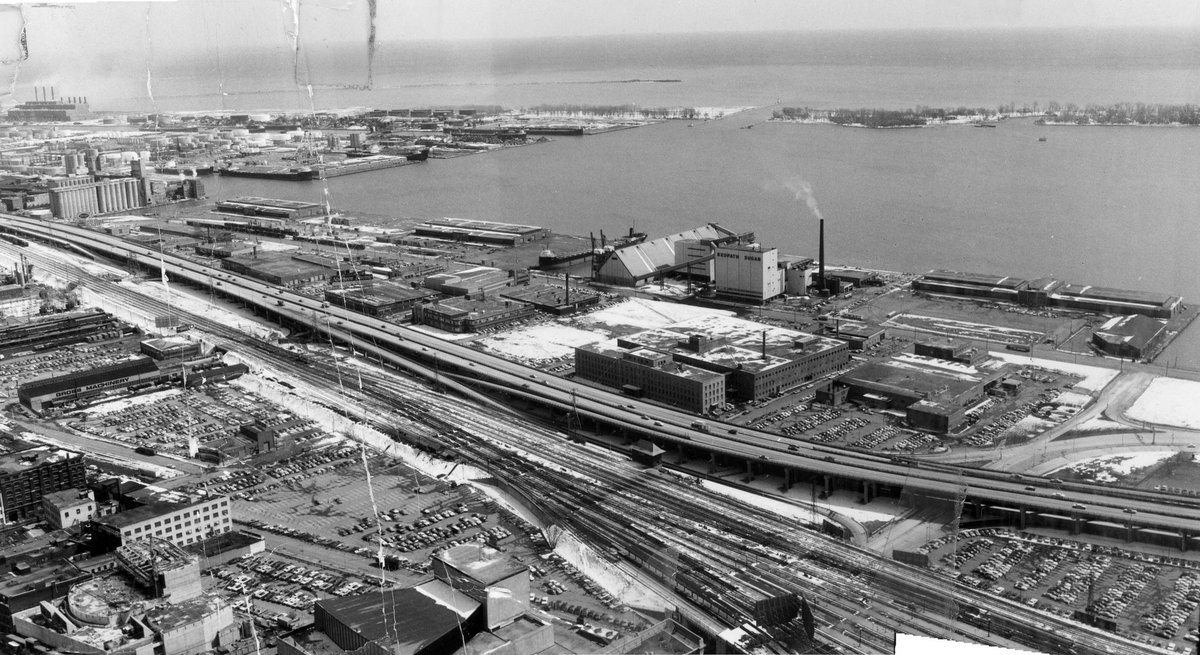
Three photos merged. A view southeast, picking up marine terminals, the Redpath sugar plant, and the broader commercial port. Today, huge projects in progress, including One Yonge, Sugar Wharf, East Bayfront, Quayside, and the Don Mouth Naturalization.
Three photos merged. A view southeast, picking up marine terminals, the Redpath sugar plant, and the broader commercial port. Today, huge projects in progress, including One Yonge, Sugar Wharf, East Bayfront, Quayside, and the Don Mouth Naturalization.
#TPBscan #94
A Tale of Two Roundhouses.
Three merged photos, looking SW from TD Centre.
Left: Canadian Pacific Railway’s John Street Roundhouse.
Right: Canadian National Railway’s Spadina Roundhouse (demolished 1986).
In the distance, Fort York, CNE, pre-Ontario Place lakeshore.
A Tale of Two Roundhouses.
Three merged photos, looking SW from TD Centre.
Left: Canadian Pacific Railway’s John Street Roundhouse.
Right: Canadian National Railway’s Spadina Roundhouse (demolished 1986).
In the distance, Fort York, CNE, pre-Ontario Place lakeshore.

#TPBscan #95
The year is 1962. Who wants to spend a few weeks taking a walk up Yonge?
We begin at 199 Yonge, looking north. Colonial Tavern sandwiched between two flagship bank buildings (now Massey Tower). Beyond them, Rose Jewellers, Bright’s Wines, and Adams Furniture.
The year is 1962. Who wants to spend a few weeks taking a walk up Yonge?
We begin at 199 Yonge, looking north. Colonial Tavern sandwiched between two flagship bank buildings (now Massey Tower). Beyond them, Rose Jewellers, Bright’s Wines, and Adams Furniture.

#TPBscan #96
Yonge & Shuter.
A good look at the Ryrie Building, (229 Yonge St). The Silver Rail Restaurant and Cocktail Bar on the corner (now Sweat and Tonic). Other ground floor shops: The Casual Shop, Williams Hat Shop. Pennington’s, London Luggage Shop, Coles Sporting Goods.
Yonge & Shuter.
A good look at the Ryrie Building, (229 Yonge St). The Silver Rail Restaurant and Cocktail Bar on the corner (now Sweat and Tonic). Other ground floor shops: The Casual Shop, Williams Hat Shop. Pennington’s, London Luggage Shop, Coles Sporting Goods.

#TPBscan #97
Another look at the Ryrie Building, this time from the north, providing a good view of the ground floor shops.
In the offices above, many jewellers, importers, lawyers, dentists, etc. My favourite: Unit 311, Acme Investigation Bureau Private Investigators.
Another look at the Ryrie Building, this time from the north, providing a good view of the ground floor shops.
In the offices above, many jewellers, importers, lawyers, dentists, etc. My favourite: Unit 311, Acme Investigation Bureau Private Investigators.

#TPBscan #98
239 Yonge: Bata Shoes (summer sale, additional giant reductions). So many light bulbs in that sign!
241 Yonge: Evangelical Books / Beacon Cameras. The narrow four-storey building still stands today.
239 Yonge: Bata Shoes (summer sale, additional giant reductions). So many light bulbs in that sign!
241 Yonge: Evangelical Books / Beacon Cameras. The narrow four-storey building still stands today.

#TPBscan #99
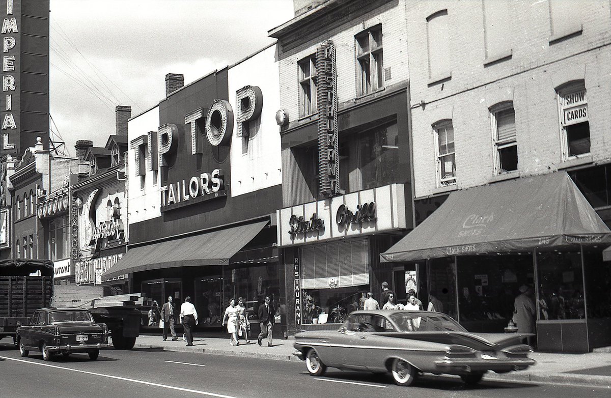
243-255 Yonge Street.
Clark Shoes.
State Grill.
Tip Top Tailors.
Superior Tea Rooms.
Imperial Theatre sign visible a few shops to the north.
243-255 Yonge Street.
Clark Shoes.
State Grill.
Tip Top Tailors.
Superior Tea Rooms.
Imperial Theatre sign visible a few shops to the north.
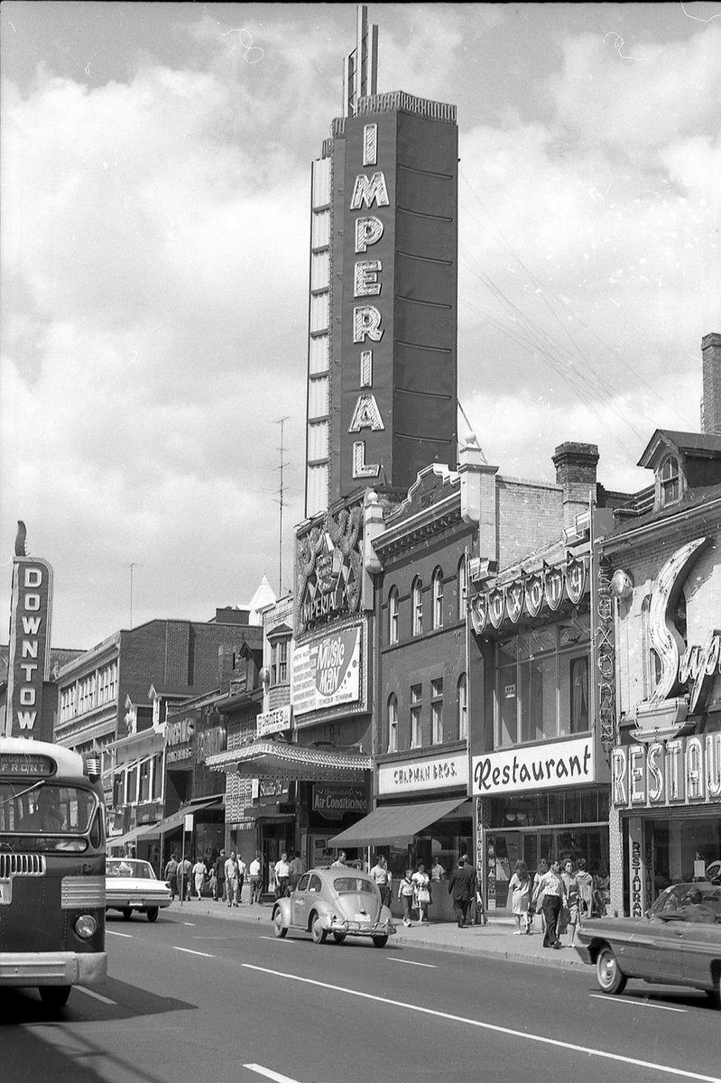
#TPBscan #100
A nice look at the Imperial Theatre. 3,600 seats! Playing: ‘The Music Man’. I grew up with this as the Imperial Six. Since then, Pantages -> Canon Thtr -> Ed Mirvish Thtr.
Also:
- Saxony Restaurant
- Chapman Bros. Jewellers
- TTC Twin Coach bus heading south
A nice look at the Imperial Theatre. 3,600 seats! Playing: ‘The Music Man’. I grew up with this as the Imperial Six. Since then, Pantages -> Canon Thtr -> Ed Mirvish Thtr.
Also:
- Saxony Restaurant
- Chapman Bros. Jewellers
- TTC Twin Coach bus heading south
#TPBscan #101
267-275 Yonge Street.
- Studio 267 (The Men’s Shop)
- Dante’s After Hours Dancing (great sign)
- Interesting vacant storefront
- Bond Clothes
- Durbin’s Credit Jewellers
- Ed Provan Clothes
267-275 Yonge Street.
- Studio 267 (The Men’s Shop)
- Dante’s After Hours Dancing (great sign)
- Interesting vacant storefront
- Bond Clothes
- Durbin’s Credit Jewellers
- Ed Provan Clothes

Then/now:


#TPBscan #102
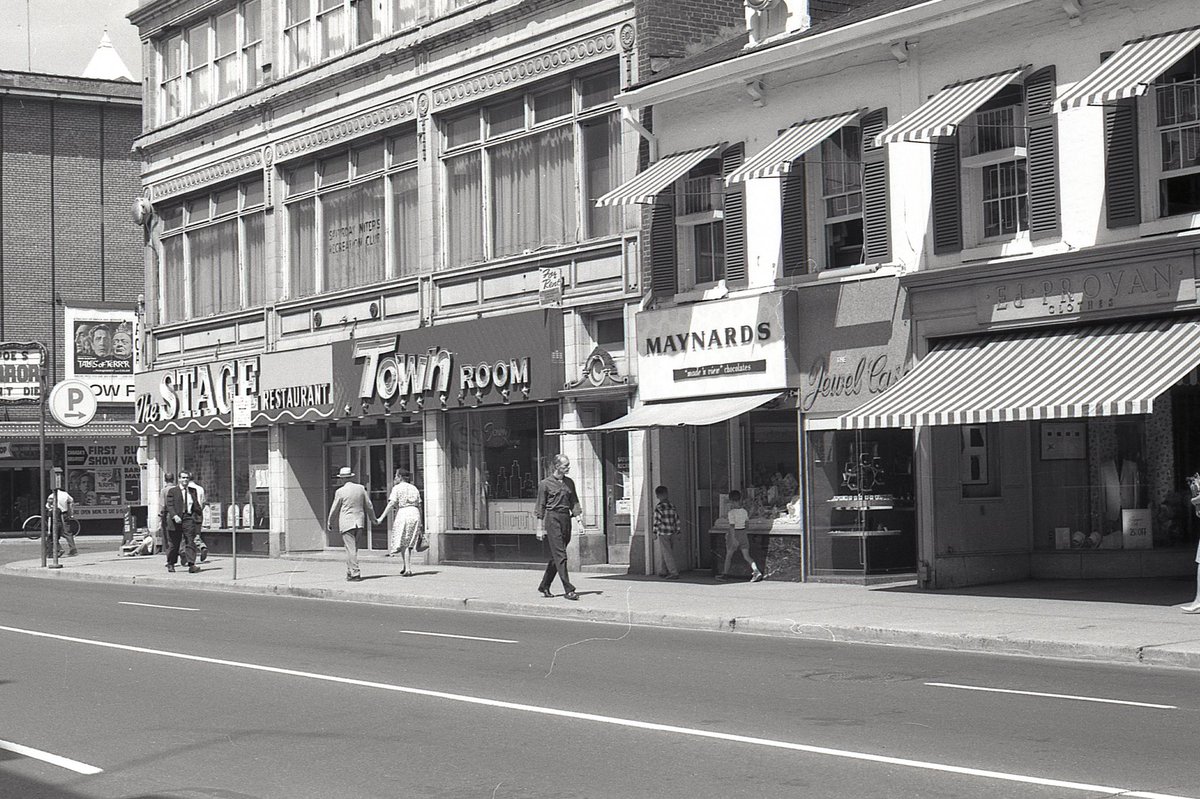
A pair of heritage designated buildings.
275-277 Yonge (John Bugg Store)
- Ed Provan Clothes
- The Jewel Case
- Maynards ‘made in view’ chocolates
279-283 Yonge (Child’s Restaurant)
- The Stage Restaurant / Town Room
- now a Shoppers, previously Hard Rock Cafe
A pair of heritage designated buildings.
275-277 Yonge (John Bugg Store)
- Ed Provan Clothes
- The Jewel Case
- Maynards ‘made in view’ chocolates
279-283 Yonge (Child’s Restaurant)
- The Stage Restaurant / Town Room
- now a Shoppers, previously Hard Rock Cafe

Then/now:

#TPBscan #103
The 1,059-seat Downtown Theatre.
Now that’s a movie marquee:
‘Edgar Allen Poe’s Tales of Terror’
‘Brain That Wouldn’t Die’
Today, this would be a view of Yonge-Dundas Square, from the southwest, looking northeast.
The 1,059-seat Downtown Theatre.
Now that’s a movie marquee:
‘Edgar Allen Poe’s Tales of Terror’
‘Brain That Wouldn’t Die’
Today, this would be a view of Yonge-Dundas Square, from the southwest, looking northeast.

#TPBscan #104
Yonge and Dundas, 1962.
On the northeast corner, the Brown Derby Tavern. Supposedly had Canada’s longest bar - 114 seats. Basement lounge was the ‘gay nineties (1890s) room’.
Rooftop Globe & Mail news ticker reads: ‘businessman Wallace McCain...’
Yonge and Dundas, 1962.
On the northeast corner, the Brown Derby Tavern. Supposedly had Canada’s longest bar - 114 seats. Basement lounge was the ‘gay nineties (1890s) room’.
Rooftop Globe & Mail news ticker reads: ‘businessman Wallace McCain...’

#TPBscan #105
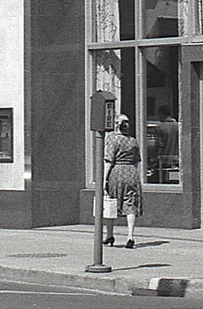
SE corner of Yonge and Dundas. Continental Clothes. I remember this corner as ‘World’s Biggest Jean Store’ (Rockwell Jeans). Eventually expropriated for Yonge-Dundas Square.
Sign at subway entrance says ‘northbound only’. Pedestrian tunnel under tracks came later.
SE corner of Yonge and Dundas. Continental Clothes. I remember this corner as ‘World’s Biggest Jean Store’ (Rockwell Jeans). Eventually expropriated for Yonge-Dundas Square.
Sign at subway entrance says ‘northbound only’. Pedestrian tunnel under tracks came later.

#TPBscan #106
The 929-seat Biltmore Theatre. After closing in 1986, the location was home to the ‘Yonge Dundas Shopping Mall, a sort of flea market operation. One of many lots assembled and redeveloped as Metropolis, now named ‘The Tenor’.
The 929-seat Biltmore Theatre. After closing in 1986, the location was home to the ‘Yonge Dundas Shopping Mall, a sort of flea market operation. One of many lots assembled and redeveloped as Metropolis, now named ‘The Tenor’.

#TPBscan #107
Looking north from 327 Yonge:
-Disney Shop (men’s wear)
-Empire Shoe Repairs
-Times Square Books and Magazines
-Le Coq D’Or Tavern (great signage!)
-Upstairs, Olympia Bowling
(Olympian Recreation Club)
-Edison Hotel (originally the Empress Hotel - lost to fire)
Looking north from 327 Yonge:
-Disney Shop (men’s wear)
-Empire Shoe Repairs
-Times Square Books and Magazines
-Le Coq D’Or Tavern (great signage!)
-Upstairs, Olympia Bowling
(Olympian Recreation Club)
-Edison Hotel (originally the Empress Hotel - lost to fire)

#TPBscan #108
335 Yonge Street. The Edison Hotel (‘Dancing Nightly’). Another great sign - wish I’d seen Yonge at night in this era.
As a teen, I remember an arcade in the basement.
As a planning student, lunch at Salad King.
Demolished around 2010, lot is now a food market.
335 Yonge Street. The Edison Hotel (‘Dancing Nightly’). Another great sign - wish I’d seen Yonge at night in this era.
As a teen, I remember an arcade in the basement.
As a planning student, lunch at Salad King.
Demolished around 2010, lot is now a food market.

#TPBscan #109
A look back south towards the Biltmore Theatre, at 319 Yonge Street.
Upstairs, at 321-325 Yonge, a sign indicating the opening of ‘Club Nocturne’ (exotic food / jazz, entertainment / dancing).
A look back south towards the Biltmore Theatre, at 319 Yonge Street.
Upstairs, at 321-325 Yonge, a sign indicating the opening of ‘Club Nocturne’ (exotic food / jazz, entertainment / dancing).

#TPBscan #110
Yonge & Gould.
Two giants of vinyl sales: Sam the Record Man and A&A, Steele’s Tavern in between.
The iconic neon record didn’t appear until 1971.
Eventually Sam’s absorbed everything from the CIBC up to Steele’s.
Today, this is the Ryerson Student Learning Centre.
Yonge & Gould.
Two giants of vinyl sales: Sam the Record Man and A&A, Steele’s Tavern in between.
The iconic neon record didn’t appear until 1971.
Eventually Sam’s absorbed everything from the CIBC up to Steele’s.
Today, this is the Ryerson Student Learning Centre.

Interesting street furniture detail:
#TPBscan #111
A closer look at Steele’s Tavern, between Sam the Record Man and A&A. Yesterday I learned from @loklyokl and @hockeyesque that Steele’s is where Gordon Lightfoot got started.
Also: giant thermometer!
A closer look at Steele’s Tavern, between Sam the Record Man and A&A. Yesterday I learned from @loklyokl and @hockeyesque that Steele’s is where Gordon Lightfoot got started.
Also: giant thermometer!

#TPBscan #112
Zanzibar has been around a long time! I believe this is before it transitioned from live music to adult entertainment.
Mix of shops to the south: skate exchange, beauty salon, optometrist, restaurants. Bet the corned beef was good. ❤️ the signage and awnings.
Zanzibar has been around a long time! I believe this is before it transitioned from live music to adult entertainment.
Mix of shops to the south: skate exchange, beauty salon, optometrist, restaurants. Bet the corned beef was good. ❤️ the signage and awnings.

#TPBscan #113
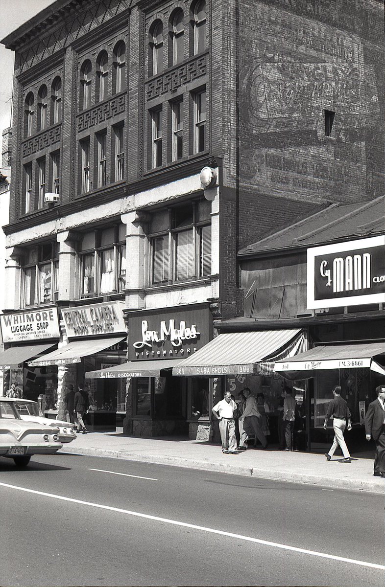
363-365 Yonge Street, Richard S. Williams Block (1890). Lovely brickwork & upper floor windows. Ghost mural!
- Cy Mann Clothes
- Saba Shoes
- Lou Myles Disegnatore
- Central Camera
- Whitmore Luggage
This heritage-designated building is currently a retained facade.
363-365 Yonge Street, Richard S. Williams Block (1890). Lovely brickwork & upper floor windows. Ghost mural!
- Cy Mann Clothes
- Saba Shoes
- Lou Myles Disegnatore
- Central Camera
- Whitmore Luggage
This heritage-designated building is currently a retained facade.
#TPBscan #114
Apart from the facade of the Yonge Street Mission, this stretch of streetscape no longer exists.
Yet another old theatre: the Rio.
Playing: Robert Mitchum in The Sundowners (1960), and Alan Ladd in Hell Below Zero (1954).
Bermuda Tavern visible north of the Rio.
Apart from the facade of the Yonge Street Mission, this stretch of streetscape no longer exists.
Yet another old theatre: the Rio.
Playing: Robert Mitchum in The Sundowners (1960), and Alan Ladd in Hell Below Zero (1954).
Bermuda Tavern visible north of the Rio.

#TPBscan #115
Look at those storefronts in the middle. The House of Mann, with its plank siding and rooftop carriage. Bermuda Tavern, with its vertical signage and neon ‘home of the steer’.
Also, a good look at the Rio marquee, and a bike leaning against the Yonge St Mission.
Look at those storefronts in the middle. The House of Mann, with its plank siding and rooftop carriage. Bermuda Tavern, with its vertical signage and neon ‘home of the steer’.
Also, a good look at the Rio marquee, and a bike leaning against the Yonge St Mission.

#TPBscan #116
A nice look at 381 Yonge Street. Heritage-designated in 2019. This 1953 building, by Mathers & Haldenby, replaced the Yonge Street Mission’s previous building at the same address.
The facade is currently being retained as part of a large development underway.
A nice look at 381 Yonge Street. Heritage-designated in 2019. This 1953 building, by Mathers & Haldenby, replaced the Yonge Street Mission’s previous building at the same address.
The facade is currently being retained as part of a large development underway.

#TPBscan #117
385-391 Yonge Street, the Gerrard Building (Sproatt & Rolph, 1924). West/north facades stabilized/retained.
- CBC
- Shelton Sherwood Musical Instruments
- Bassel’s Restaurant
(in my day: The Big Slice)
North of Gerrard, another theatre visible! (Odeon Coronet)
385-391 Yonge Street, the Gerrard Building (Sproatt & Rolph, 1924). West/north facades stabilized/retained.
- CBC
- Shelton Sherwood Musical Instruments
- Bassel’s Restaurant
(in my day: The Big Slice)
North of Gerrard, another theatre visible! (Odeon Coronet)

#TPBscan #118
Final shot from this ‘62 walk up Yonge Street.
Yonge & Gerrard, looking southeast at 373-391 Yonge, from the Rio Theatre to the Gerrard Bldg. All now demolished, with some retained facades to be part of Concord Sky.
Lots of tail fins & whitewalls in this roll.
Final shot from this ‘62 walk up Yonge Street.
Yonge & Gerrard, looking southeast at 373-391 Yonge, from the Rio Theatre to the Gerrard Bldg. All now demolished, with some retained facades to be part of Concord Sky.
Lots of tail fins & whitewalls in this roll.

• • •
Missing some Tweet in this thread? You can try to
force a refresh