Thanks to the first volume of Michael Palin's diaries, I've just discovered the glory of one of the greatest travel pieces in British publishing history.
In early April 1977, The Guardian published a 7-page travel supplement on this "little-known" island nation:
(1/)
In early April 1977, The Guardian published a 7-page travel supplement on this "little-known" island nation:
(1/)

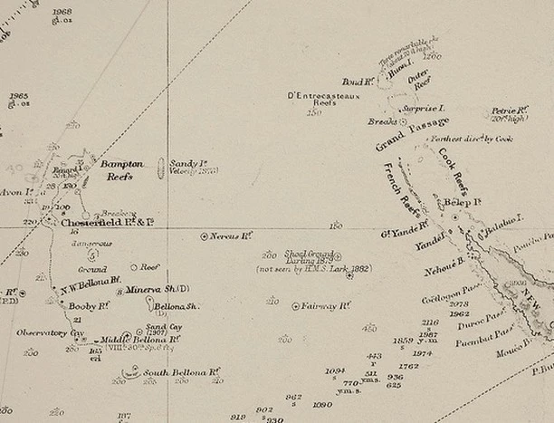
Great attention should be paid to the place names being used here.
Also that this is 1977, and web design wasn't a thing yet.
(2/)
Also that this is 1977, and web design wasn't a thing yet.
(2/)

The accompanying adverts were impressive - especially if you took the time to read them closely.
(3/)
(3/)


Further surprises awaited in the text:
“… the islands will accelerate at first gently and then more rapidly as they approach Sri Lanka. Simple calculations suggest that the island group will hit the coast of Sri Lanka at a velocity of 940 km an hour on January 3, 2011.”
(4/)
“… the islands will accelerate at first gently and then more rapidly as they approach Sri Lanka. Simple calculations suggest that the island group will hit the coast of Sri Lanka at a velocity of 940 km an hour on January 3, 2011.”
(4/)
And you have to admire quality destination marketing copy like this:
"…[enjoy] the many beaches from which terrorism has been virtually eliminated…”
(5/)
"…[enjoy] the many beaches from which terrorism has been virtually eliminated…”
(5/)
San Seriffe's indigenous people, the Flongs, were apparently celebrated every year with "the Festival of the Well Made Play."
(Another typography joke. A flong is actually a curved papier-mâché mould used in rotary letterpresses.)
(6/)
(Another typography joke. A flong is actually a curved papier-mâché mould used in rotary letterpresses.)
(6/)
The two islands are called Upper Caisse and Lower Caisse.
How many typeface names can you spot?
The peninsula at the bottom is called Thirty Point.
Dead giveaways? This was 1977 - and no major newspaper had been this wilfully daft before. Fooled plenty.
(7/)
How many typeface names can you spot?
The peninsula at the bottom is called Thirty Point.
Dead giveaways? This was 1977 - and no major newspaper had been this wilfully daft before. Fooled plenty.
(7/)

The cleverest bit of this:
It was originally going to be a single page. But then the Guardian realized a bigger (faked) feature would generate *more* money by running themed advertising - if advertisers were in cahoots & playing along.
They agreed.
It worked.
Genius.
(8/)
It was originally going to be a single page. But then the Guardian realized a bigger (faked) feature would generate *more* money by running themed advertising - if advertisers were in cahoots & playing along.
They agreed.
It worked.
Genius.
(8/)
And it's hard to convey *just how much* those advertisers went along with this hoax.
It's spectacular.
(9/)
It's spectacular.
(9/)

Guardian Deputy Editor David McKie recalled:
"The impact of the seven-page survey was quite astonishing. The office all day was bedlam as people pestered the switchboard with requests for more information...[they] simply refused to believe that the islands did not exist."
(10/)
"The impact of the seven-page survey was quite astonishing. The office all day was bedlam as people pestered the switchboard with requests for more information...[they] simply refused to believe that the islands did not exist."
(10/)
The Guardian also sold a ton of "I've been to San Serriffe" bumper stickers - and, apparently, around 12,000 San Serriffe t-shirts.
I mean wtaf.
(11/)
I mean wtaf.
(11/)
For more pics of those....*incredible* adverts, and of the whole article itself, check out Doug Wilson's piece on San Serriffe here:
realdougwilson.com/writing/san-se…
Plus various pieces at the @guardian, eg. theguardian.com/gnmeducationce…
realdougwilson.com/writing/san-se…
Plus various pieces at the @guardian, eg. theguardian.com/gnmeducationce…
And lastly, I'm just about to start the second season of my curiosity newsletter, Everything Is Amazing - and it's partly going to be about fake maps. You might enjoy!
everythingisamazing.substack.com/about
Thanks for reading. :)
everythingisamazing.substack.com/about
Thanks for reading. :)
If you liked this thread:
The new season of my newsletter is partly about exploring 'Terra Ineptias' - the landscape of glorious, absurd ways that fake maps have been used to befuddle and hoodwink folk for centuries. The first update:
everythingisamazing.substack.com/p/week-2-1-cha…
Ta!
The new season of my newsletter is partly about exploring 'Terra Ineptias' - the landscape of glorious, absurd ways that fake maps have been used to befuddle and hoodwink folk for centuries. The first update:
everythingisamazing.substack.com/p/week-2-1-cha…
Ta!

...and in week 2, it's about how even Wikipedia, with its 200,000 hardworking editors, isn't immune to such gloriously absurd acts of fakery:
everythingisamazing.substack.com/p/week-2-2-is-…
(Some evaded detection for over a *decade*. Totally bonkers.)
everythingisamazing.substack.com/p/week-2-2-is-…
(Some evaded detection for over a *decade*. Totally bonkers.)
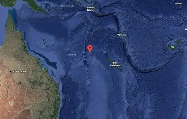
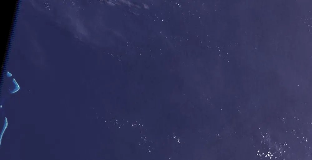
Staying with fake places, this is an equally barmy story (and equally true):
https://twitter.com/Mikeachim/status/1412780349638250497
• • •
Missing some Tweet in this thread? You can try to
force a refresh