Known to the Klickitat as Louwala-Clough, or "smoking mountain," Mount St. Helens erupted on this day in 1980 and became the deadliest and most destructive volcanic eruption in U.S. history.
On March 27, 1980, the volcano produced its first eruption in over 100 years. Steam explosions created a 250-foot wide crater.
This photograph shows the ash-darkened east slopes of Mount St. Helens on March 30, 1980. Ninety-three explosions took place that day.
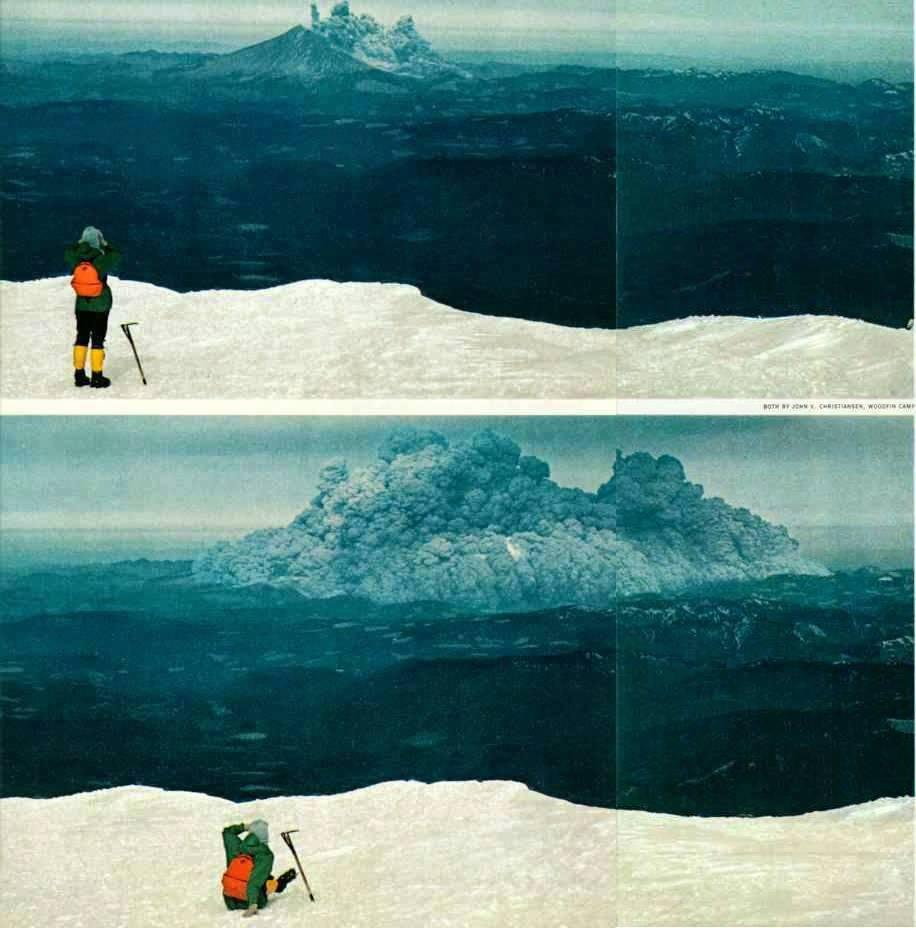
The mountain erupted at 8:32 a.m. on May 18, 1980.
Following the landslide, a massive vertical ash column that stretched 12 miles above the crater formed. The swirling ash particles in the atmosphere generated lightning, which, in turn, started several forest fires.
Smaller eruptions occurred throughout the summer and fall. The magma at Mount St. Helens is very sticky, and by October 1980, the episodic eruptions built a new lava dome that reached 1,000 feet above the crater floor.
Lidar imagery shows us lava dome growth at Mount St. Helens between 2002 and 2009. The Crater Glacier is highlighted in the last frame.
• • •
Missing some Tweet in this thread? You can try to
force a refresh
All good hikes must come to an end, and in this case, I’ve made it back to my car sweaty, exhilarated, and craving something greasy.
Today is my last day at @waDNR, and I can't help but look back with gratitude (and a little bewilderment tbh)
These past three years, I’ve had the privilege to work with and learn from some of the most passionate and brilliant public servants in Washington state.
Here's a look back on some of my favorite things we made together:
That time we all agreed setting the state on fire is bad
In recognition for her efforts to highlight the geologic Eras that formed the planet and for shaping our world as much as the tectonic plates beneath us, we have selected @taylorswift13 as an Honorary Geologist for the state of Washington.
“Moving forward, this geologic partnership with Taylor is going to be forever, or it’s going to go down in flames,” said Commissioner @Hilary_FranzCPL.
Recipients of DNR’s Honorary Geologist title receive the opportunity to perform two nights at Seattle’s Lumen Field.
What do Taylor’s eras teach us about Earth’s geologic eras? Buckle up. Ms. Swift is about to teach us geology.
8:32 a.m. May 18, 1980: Mount St. Helens erupts and becomes the deadliest and most destructive volcanic eruption in U.S. history.
This hiker witnessed the eruption from neighboring Mount Adams, a moment captured by photographer John V. Christiansen.
A timelapse of the Mount St. Helens eruption made from photographs stitched together that were taken over a span of about 40 seconds by Gary Rosenquist.
We dove into our geology library to find some images from before, during, and after the eruption.
L to R:
- The north side of Mount St. Helens, 1980
- A bulge develops on the north side as magma pushed up within the peak
- The eruption seen 20 miles away
- MSH in 1981