Scott Duncan Profile picture
Jun 21, 2021 7 tweets 4 min read Read on X
The Arctic heatwave ongoing in Siberia is contributing to continued record-low sea ice extent in the Laptev Sea. It reached a staggering +31.4°C (88.5°F) at 73 degrees north.

NASA satellite imagery just in captures the break-up in exceptional detail.

THREAD ImageImage
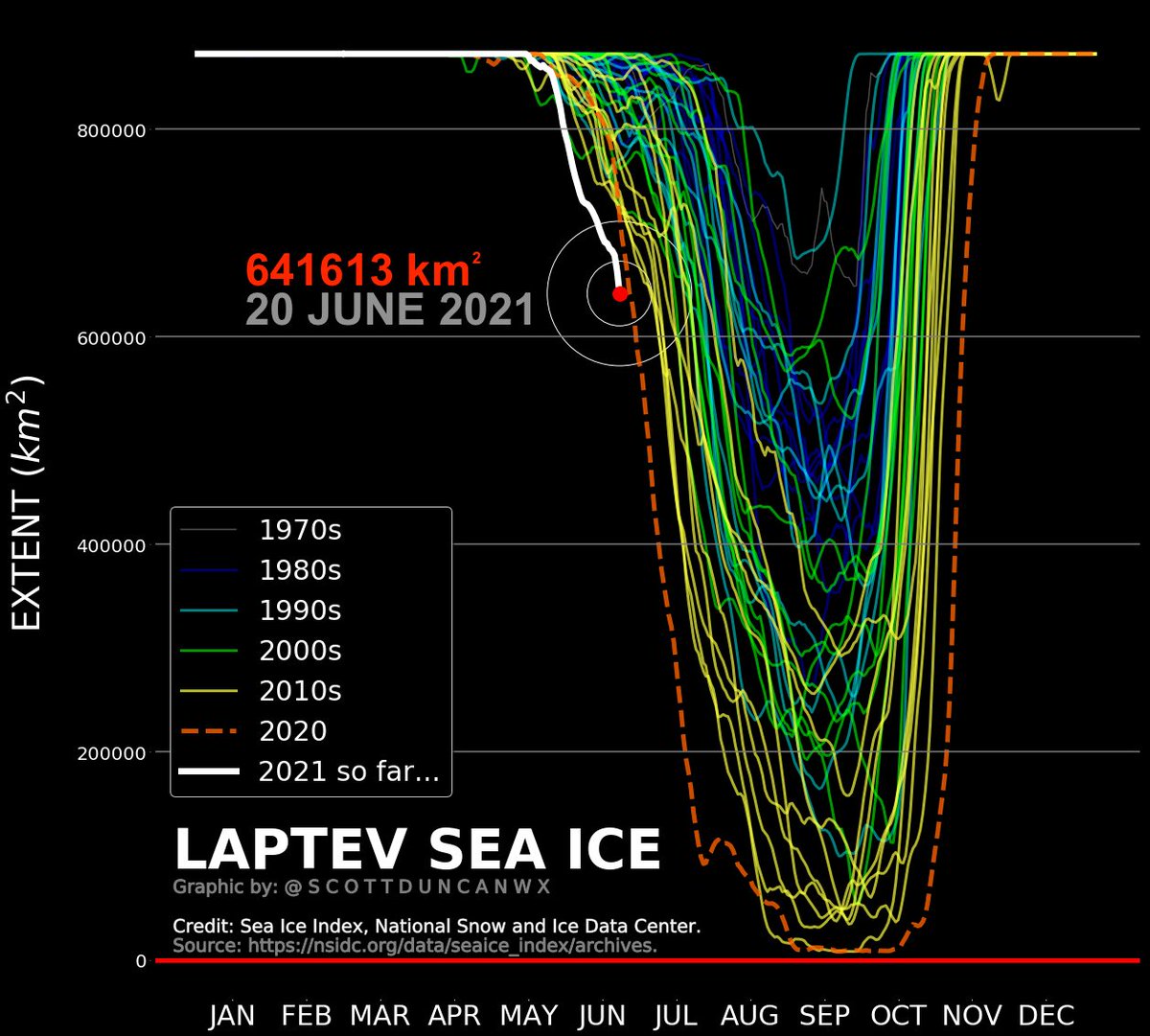
This is the Laptev Sea ice extent up to 20 June 2021.

2020 was by far the most extreme melt season in the area. But this year continues to break that record comfortably. ImageImage
This is the weather observations from earlier today in the area.

For those interested, you can access these maps at: ogimet.com/cgi-bin/ogimet… ImageImage
To be clear, this is not a temperature record. I have been chatting with @EKMeteo and he has reminded us that last year reached 31.4°C on 24 June here and then a mind-blowing 34.3°C on 30 June 2020.

The low ice extent in the surrounding Laptev Sea is record breaking.
Those looking for the satellite imagery, you can grab it here: worldview.earthdata.nasa.gov

An excellent resource for observing our planet. ImageImage
Roasting hot out there. We are also at the summer solstice, relentless daylight and minimum temperature not dropping below 20-25°C widely within the Arctic Circle.

This is referred to as a 'tropical night'. Although, the word 'night' is rather redundant in Arctic summer.
Temperatures are locally 20-25°C hotter than the climate average for this time of year. This part of the world gets some of the most impressive temperature extremes.

Map via @khaustein's website here: karstenhaustein.com/climate.php Image

• • •

Missing some Tweet in this thread? You can try to force a refresh
 

Keep Current with Scott Duncan

Scott Duncan Profile picture

Stay in touch and get notified when new unrolls are available from this author!

Read all threads

This Thread may be Removed Anytime!

PDF

Twitter may remove this content at anytime! Save it as PDF for later use!

Try unrolling a thread yourself!

how to unroll video
  1. Follow @ThreadReaderApp to mention us!

  2. From a Twitter thread mention us with a keyword "unroll"
@threadreaderapp unroll

Practice here first or read more on our help page!

More from @ScottDuncanWX

Sep 15
Flooding disaster unfolding right now in Central Europe.

Why is it so bad?

This thread takes a quick look at some of the key ingredients of this record-breaking storm.
Image
Image
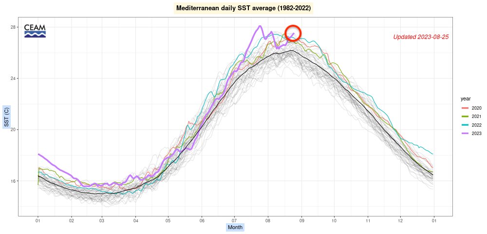
Let’s start with the background. It has been an exceptional Summer for the Mediterranean Sea. Heat records have been broken.

Warmer sea surface temperatures allow more moisture to evaporate, like fuel for a storm. The warmer the water, the greater the evaporation…
We then had a historic cold wave (for this early in September) plunge south out of the Arctic and through Europe.

We now have an unprecedented combination of hot and cold (ideal for strong thermal boundaries/weather fronts).
Read 12 tweets
Sep 14
Insane full-winter scenes emerging from Austria right now. The historic September storm in Central Europe is delivering record cold, record early deep snow and heavy flooding rains.

This is Obertauern (resort elevation range 1600-2500 m).

For those who may not believe this report, the live webcams reveal all. Blizzard conditions with drifting deep snow. This camera is 1700 m elevation.

obertauern.com/en/service-inf…
Image
The storm came as no surprise. Weather models were in good agreement that exceptional cold, snow, rain and wind would impact Central Europe several days in advance. Austria is in the bullseye.

Read 6 tweets
Sep 12
Shock to the system 🥶

Unusually strong cold is pouring south out of the Arctic into Europe right now. This is an ideal setup for deep fresh snow accumulations in the Alps and flooding in Central Europe.

This is about as cold as it gets this early in September.
Incredible contrast in temperatures.

This map shows how much cooler (🔵) or warmer (🔴) it is compared to average at this time of year. Image
This is one weather model estimation for fresh snow totals in the coming days. Well over 1 metre of fresh snow for the upper Austrian Alps expected with some places probbaly exceeding 2 metres.

Outstanding for this early in September.
Read 6 tweets
Sep 5
Very impressive weather pattern in Europe right now.

Strong easterly winds and hot in Central/Northern Europe meanwhile heavy rain plagues the west with much cooler conditions. The heat is breaking records (for this time of year).

THREAD
Image
Image
Many monthly heat records set in Germany 🇩🇪 yesterday... Beating some records which have stood for a long time (1895). Great summary here by @EKMeteo which links to comments by official @DWD_presse

@EKMeteo @DWD_presse It appears Norway has broken September national heat record, final numbers to be confirmed.

Impressive foehn effect to the west of high ground. The dry easterly winds in southern Norway is ideal setup for incredible temperatures in unusual places.

Read 5 tweets
Mar 3
Truly outlandish.

Some places in Europe didn't just record their warmest February on record.... They went on to beat their warmest MARCH temperature levels.

[THREAD] Image
Effectively everywhere in the dark red shading smashed warmest February record - most by large margin. Austria 🇦🇹 has over 250 years of temperature record and nothing compares to this. Not even close.

Source: zamg.ac.at/cms/de/klima/n…
Image
Wiener Neustadt in the east of Austria was so warm that temperature of February 2024 exceeded the warmest MARCH record (data here since 1949).

uwz.at/de/a/waermer-a…
Read 11 tweets
Aug 27, 2023
Heatwave going out with a bang in Europe.

Watch how the jet stream digs aggressively into Southern Europe. The atmosphere is primed for severe weather - unfolding right now...
This animation captures the transition from extreme heat (unprecedented for this late in August) to relatively cool conditions.

The variable shown here is the temperature at 850 hPa (usually around 1.5km above sea level). This can help show where our airmass is coming from.
The Mediterranean is also acting like an extra source of fuel for the storms. The sea surface temperatures are at record hot levels.

The Gulf of Lion (just south of France) is especially hot. The sea surfaces will likely cool dramatically during this breakdown.

You can access the satellite derived sea surface temperature data here:

The graph can be found here:
Read 7 tweets

Did Thread Reader help you today?

Support us! We are indie developers!


This site is made by just two indie developers on a laptop doing marketing, support and development! Read more about the story.

Become a Premium Member ($3/month or $30/year) and get exclusive features!

Become Premium

Don't want to be a Premium member but still want to support us?

Make a small donation by buying us coffee ($5) or help with server cost ($10)

Donate via Paypal

Or Donate anonymously using crypto!

Ethereum

0xfe58350B80634f60Fa6Dc149a72b4DFbc17D341E copy

Bitcoin

3ATGMxNzCUFzxpMCHL5sWSt4DVtS8UqXpi copy

Thank you for your support!

Follow Us!

:(