
Zoviet Maps (1/x)
Soviet maps reached a detail level unbelievable for many rival intelligence agencies. They can tell you about the height of a bridge above water, its dimensions, load capacity, and the main construction material.
Soviet maps reached a detail level unbelievable for many rival intelligence agencies. They can tell you about the height of a bridge above water, its dimensions, load capacity, and the main construction material.

(2/x) They can tell you the width of a river, the direction of its flow, its depth, and whether it has a viscous bed. They can tell you the type of trees in a forest, as well as their height, girth, and spacing. They can also tell you the name of a factory and what it produces.

(3/x) Swedish experts concluded Soviet maps of Sweden were “better than the creations of the best Swedish military mappers” and ruined the myth that “Sweden managed to conceal very important information about its coastal defence from Russians.”

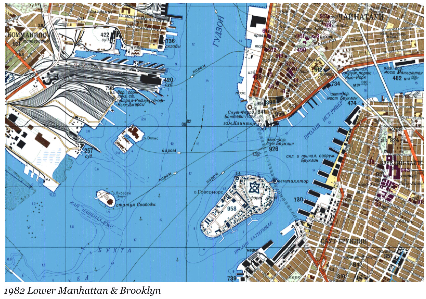
(4/x) The Russian maps “contained the information even about the berth length and the depth at secret naval bases, not to mention the location of secret mine fields.”

(5/x) What’s the purpose of amassing such detail? Why does a Soviet Military Staffer care about the width of the New River Gorge Bridge in Fayetteville, West Virginia when all these details will be literally and figuratively rubbish after a nuclear strike?
(6/x) There are two suggested reasons: 1) economic and 2) civil administration.
(7/x) Economically, the Soviets tried to understand how America achieved its post-WW2 prosperity by studying its industrial geography, hence its emphasis in the maps.
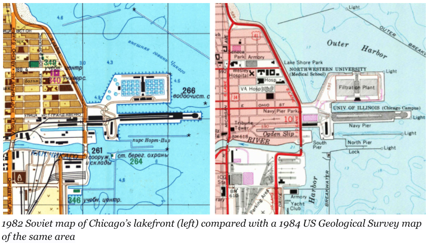
(8/x) There are maps produced on the highly detailed 1:10,000 scale for American cities that many Americans themselves are unaware of: Galveston (TX), Scranton (PA), Pontiac (MI), Watertown (NY).
Astute observers will notice these places center around heavy industry, shipping, or energy development. For city maps, there were separate city descriptions that discussed “General Information,” “Industry and Transport,” “Economy,” “Topography,” “Climate,” and “Communications.”

(10/x) Given the lack of emphasis on enemy military installations and emphasis on detailed infrastructure, like bus spots, some believe these maps were to help plan for a coup and rule in the event of one.
(11/x) When examining the maps, it is clear that they are interested in mapping transportation methods (road, rail, air networks) and places of production (power stations, water mills, manufacturing and repair facilities), not cultural landmarks.
(12/x) In Soviet maps of Ireland, long abandoned rural water mills of no importance are shown whereas many ecclesiastical buildings are ignored.
(13/x) Soviets had POWERFUL train autism. This shows in their maps. Because of the importance of trains in Soviet society, they paid a level of attention to trains largely absent in Western minds, especially for Americans.

(14/x) Examples of information included about trains that would not be found on Western maps are: distinguishing between electrified and non-electrified lines, the number of tracks, the location of station buildings relative to the tracks, the dimensions of tunnels,...
(15/x)...the name of railroad companies, and the position of signal gantries. Additionally, the railroad diagrams are geographically correct unlike the distorted guides you will see for the NYC MTA subway map.
(16/x) How did the Soviets achieve unparalleled detail?
(17/x) You may think they just copied the publicly available maps from Western countries. But 1) the maps included details that Western maps did not have (that couldn’t either be determined from aerial imagery) and
(18/x) 2) Soviets distrusted any publicly available documents, and assumed they were full of disinformation, making them vigilant in creating their own maps.

(19/x) To this day, no one is entirely sure how these maps were developed, other than the vague idea that it required a combination of Soviet spooks, informants, aerial imagery, and published maps.
(20/x) Nevertheless, it is amazing the Soviets mapped much of the world (including remote areas of Africa) at the scales of 1:10,000 (cities) and 1:50,000 and 1:100,000.

(21/x) If you're interested in purchasing previously classified Soviet military maps, visit Omnimap. Vlasenko is a free way to play around and see the Soviet maps of Ukraine at various scales.
omnimap.com/catalog/russia…
maps.vlasenko.net
omnimap.com/catalog/russia…
maps.vlasenko.net


(22/22)
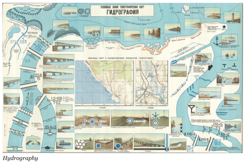
Some training posters to help officers recognize symbols on maps
Some training posters to help officers recognize symbols on maps


• • •
Missing some Tweet in this thread? You can try to
force a refresh


