Tetsuya ‘Ted’ Fujita was born on Oct. 23, 1920, in Kitakyushu City, Japan. Fujita became fascinated by weather at an early age and eventually moved to the United States to further his research. bit.ly/2ZdJswX
Fujita is credited with several monumental meteorological advancements while working as a researcher and professor at the University of Chicago: bit.ly/2ZdJswX
In 1971, Fujita unveiled a six-point rating system for categorizing tornado damage. This would become known as the Fujita Scale and helped him earn the nickname "Mr. Tornado." The scale would be used to analyze the historic super tornado outbreak of April 1974:
Fujita was described as an ‘incredibly meticulous’ individual who applied a forensic approach to meteorology. This would come in handy when it came to the discovery of a new meteorological phenomenon. bit.ly/2ZdJswX
Fujita helped investigate the cause of a plane crash in New York City in June 1975. He believed the plane had been struck by a weather phenomenon known as a microburst, a meteorological concept not broadly accepted at the time. bit.ly/2ZdJswX
Fujita led a team to publicly identify microbursts, which are columns of sinking air in a thunderstorm less than 2.5 miles in diameter that produce damage similar to tornadoes. The first documented microburst was eventually observed on radar by Fujita about three years later.
The discovery and acceptance of microbursts would dramatically improve flight safety. Fujita’s breakthrough helped decrease the number of aviation accidents and saved scores of lives. bit.ly/2ZdJswX
Fujita worked at the University of Chicago for his entire career. An obituary published by the University of Chicago said that Fujita continued his work despite being bedridden. He died on Nov. 19, 1998, at the age of 78. bit.ly/2ZdJswX
• • •
Missing some Tweet in this thread? You can try to
force a refresh
In Florida, electric vehicles have become an increasingly popular pick for residents. However, in the wake of the Category 4 hurricane that hit the state last month, these vehicles have been more akin to a time bomb. bit.ly/3DfWb2l
Saltwater flooding in the state’s coastal areas caused the lithium ion batteries in electric vehicles to combust, catching fire.
Firefighters near Naples had to put out six blazes related to the vehicles in the days following Ian's landfall. bit.ly/3DfWb2l
Florida’s chief financial officer and state fire marshal, @JimmyPatronis, wrote that “as those batteries corrode, fires start,” giving a “new challenge” to Florida firefighters. bit.ly/3DfWb2l
It's been a decade since Superstorm Sandy sent New Jersey and neighboring states reeling as it slammed into the coastline near Atlantic City on Oct. 29, 2012.
However, some residents are still paying recoupment of overpaid funds ten years later. bit.ly/3sB0rEE
2. Sandy posed many challenges for forecasters—while transitioning from a Category 1 hurricane to a non-tropical storm, it still possessed strong surge and wind common with a hurricane. bit.ly/3sB0rEE
AccuWeather's @JLAngeline reports.
@JLAngeline 3. The storm surge from Sandy made the superstorm one of the costliest tropical cyclones to make landfall in the U.S.
Record storm surge inundated the central and northern New Jersey Shore, reaching as high as 8.9 feet above ground level at Sandy Hook. bit.ly/3sB0rEE
Already dreaming of a winter wonderland? ❄️
AccuWeather forecasters break down what to expect this winter region-by-region as well as seasonal snowfall predictions for the nation's biggest cold-weather cities: bit.ly/3CErwvx
2. AccuWeather long-range forecasters are predicting a "triple dip La Niña," as it is the third winter in a row that La Niña will shape the weather patterns across the U.S.
3. Residents in the Southeast should stay alert as warm waters off the coasts could promote frequent storms and severe weather even as autumn fades to winter. bit.ly/3CErwvx
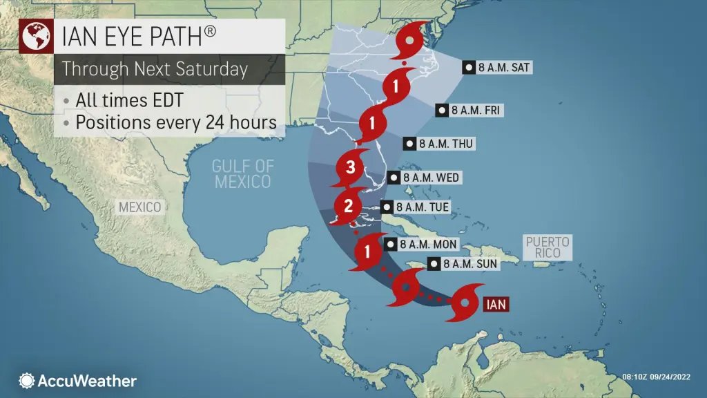
While Tropical Storm Ian has yet to reach hurricane strength, AccuWeather forecasters continue to caution that a substantial hurricane threat exists along the eastern Gulf coast of the U.S. bit.ly/3C8zfTf
While Ian remains a tropical storm for now, forecasters caution that there is a high likelihood of that soon changing.
As Ian moves into the western Caribbean, conditions are set to become much more favorable for strengthening. bit.ly/3C8zfTf
Some of Ian's worst impacts may occur in western Cuba, where conditions will likely deteriorate as early as Monday, with flooding rainfall and increasingly strong winds moving ashore. A hurricane watch remains in effect for portions of the island. bit.ly/3C8zfTf
Tropical Storm #Ian formed over the central Caribbean Sea late Friday night, the latest development stage for a tropical system that had been gradually organizing since early this week. bit.ly/3dGUiTG
Florida's governor on Friday declared a pre-landfall state of emergency for 24 counties as the threat of a damaging hurricane strike next week escalated. bit.ly/3dGUiTG
A quickly developing system will tend to track more to the east. For this reason, a track into or just off the Florida east coast is a possibility as well as a strike on the Florida west coast or the Florida Panhandle. bit.ly/3dGUiTG