There appears to be an internet blackout in Sudan today after members of the government were arrested during a military coup. @netblocks 

Sudan is back on the streets in protest against the coup and the arrest of leaders, including PM Hamdock.
This footage is from Omdurman, near Khartoum #SudanUprising.
This footage is from Omdurman, near Khartoum #SudanUprising.
Here is a thread from my friend @Drsalmaa detailing who was detained, as well as reports of the Rapid Support Forces deployed in Khartoum (the same group responsible for a massacre in June 2019).
https://twitter.com/drsalmaa/status/1452474363652055040
Security forces appear to be guarding roads leading towards the General Command in Khartoum, where civilians last staged a large pro-democratic sit-in.
Demonstrators are burning tires on some of the central roads in Khartoum. H/T to @Elmosharaf_E for the 📹
Huge crowds of demonstrators push towards the General Command in Khartoum. I hope the security forces will respect their right to protest 🙏 H/T @6a7a_hussein.
@6a7a_hussein What a procession! Moving up on Airport Rd - Africa St towards central Khartoum here: goo.gl/maps/BauoLpY7A…. All eyes will be on Sudan today. H/T @Elmosharaf_E for 📹 #لا_للانقلاب_العسكري
Not sure how effective that barrier was, but demonstrators definitely got past it and are in front on the General Command in Khartoum. Footage was filmed here: goo.gl/maps/ErCcWvG5C…. H/T @AbueissaAmel for 📹 #لا_للانقلاب_العسكري
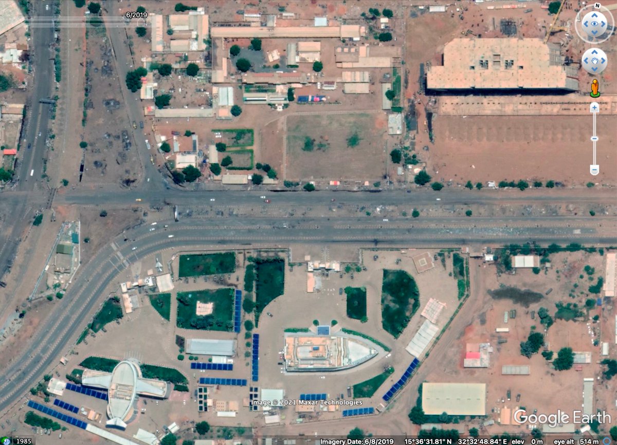
@AbueissaAmel For those wondering about the significance of this place, this is what it looked like in the beginning of 2019 (left image), when pro-democratic demonstrations staged a sit-in at the location, which was attacked and destroyed in June (right image). 📍 goo.gl/maps/Nmo1Tf93U…

Demonstrators reporting there are shots fired and gunshot injuries from the location above - looks like people fleeing the area in this footage.
They are chanting: “the military belongs to Sudan, the military doesn’t belong to Burhan”
H/T to @RealRameyDawoud for translation. #لا_للانقلاب_العسكري
H/T to @RealRameyDawoud for translation. #لا_للانقلاب_العسكري
@RealRameyDawoud On the road from Omdurman toward Khartoum's General Command - where it appears demonstrators are massing. H/T to @6a7a_hussein for 📹
Geolocation: goo.gl/maps/BJxQKnDZd…
Geolocation: goo.gl/maps/BJxQKnDZd…
@RealRameyDawoud @6a7a_hussein Reuters reporting Sudan General al-Burhan has announced a state of emergency across Sudan and the dissolution of the transitional sovereign council and the government. #الردة_مستحيلة
reuters.com/world/africa/s…
reuters.com/world/africa/s…
Heavy gunfire heard in footage from moments ago as demonstrators run to safety away from the General Command are in Khartoum. Geolocation: goo.gl/maps/C2CPgqhMW…. H/T @6a7a_hussein for 📹 #الردة_مستحيلة
Geolocation of above footage, located here goo.gl/maps/C2CPgqhMW… on Ebed Khatim St, just in front of the Burri Family Park (منتزه بري العائلي). Gunshots appear to come from General Command area where protestors were gathering.

Sudan has really gone back to square one. Security forces are cracking down on demonstrators, even pursuing & firing toward civilians in the streets.
This footage, is from today in Khartoum. The vehicles were driving up this street: goo.gl/maps/gLaaiLoJ1…. H/T to @25Wli for 📹
This footage, is from today in Khartoum. The vehicles were driving up this street: goo.gl/maps/gLaaiLoJ1…. H/T to @25Wli for 📹
• • •
Missing some Tweet in this thread? You can try to
force a refresh