
New day, new thread and, wellllllp
https://twitter.com/City_Abbotsford/status/1460635988305354752?t=Z9AttPtRJE1PnBe-GaFXUg&s=19
Not one news story (aside from ours, link below) right now, mentions Sumas Lake. Which is a problem given the crucial role it is playing in the flooding. We'll be spending our day on on the lake that was (and may be again).
fvcurrent.com/article/fraser…
google.com/search?q=%22su…
fvcurrent.com/article/fraser…
google.com/search?q=%22su…
The problem, again, is that all this Nooksack River water wants to flow downhill. And downhill isn't necessarily toward the Fraser but toward the old lake bed of Sumas Lake. Which used to look like this: 

And be located here, via Seelkee on Wikipeedia
For millennia it was at the centre of Fraser Valley life, before engineers came along and tried to engineer it away: abbynews.com/news/fraser-va…
Some have asked how does the lake get drained if it fills in? There are a series of canals that deliver water to a pump station that then keeps the lake from filling up. I'm not sure about the pumping system from the bottom of the lake bed though.
bradnerbarker.com/news/december-…
bradnerbarker.com/news/december-…
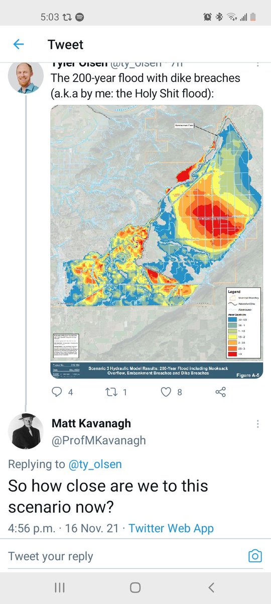
Just last year the City of Abbotsford published a report on flooding from the Nooksack. This exact thing. There were some maps included about potential scenarios. Just going to post them here. I'm not sure anyone knows what scenario we're looking at.
This is a duplicate of the 1990 flood. Judging by aerial footage, I think we are beyond this.

A 100-year flood with embankment breaches but no dike breaches

Slightly different model:

Another model:

The 200-year flood with dike breaches (a.k.a by me: the Holy Shit flood):

You can see the whole study here: abbotsford.ca/sites/default/…
On the good-news front, the Nooksack is starting to recede after hitting its limit a couple days ago.

On the not-great-news front, the Fraser River is at a bonkers level for November. At peak freshet levels. This is worth watching not b/c the Fraser will flood (it won't), but b/c it will affect how quickly Sumas Prairie can be drained.

Because, remember, the water in Sumas Prairie will want to flow downhill. When the Fraser is at typical November levels, the water more or less wants to go there. When it's at June levels, it wants to go to the bed of Sumas Lake.
Yarrow (a community in Chilliwack on the south side of the Vedder River/Canal and adjacent to Sumas Prairie) to be evacuated:
https://twitter.com/City_Chilliwack/status/1460667236327198730
Map of Yarrow evacuation zone
https://twitter.com/murraygabriel/status/1460677730853261317
The sign reads:
VERY SLOW TRAFFIC
REDUCE SPEED AHEAD
VERY SLOW TRAFFIC
REDUCE SPEED AHEAD
https://twitter.com/DriveBC/status/1460675808444383234?s=20
Photos just released from City of Abbotsford:


More:


More:


End:


Again, there is a marked contrast in the information our government provides to citizens compared to the information the state government next door provides to its citizens.
https://twitter.com/DanAshtonBC/status/1460646454930784262
MAP: This is an important question, so I made a quick map to explain. If you can't read, click the link and you should be able to zoom.
datawrapper.dwcdn.net/KijDq/1/
datawrapper.dwcdn.net/KijDq/1/
https://twitter.com/moneyman11_c/status/1460731623482216450

That map, with larger text: datawrapper.dwcdn.net/KijDq/2/

Pretty damn close! @ProfMKavanagh
Too many threads right now. The latest, on the bad scenario that looks like it's coming true.
https://twitter.com/ty_olsen/status/1460747219032629256?t=CM5W0EWXqECohQmi7H-xkA&s=19
🚨🚨🚨🚨🚨 Dire news:
https://twitter.com/city_abbotsford/status/1460813259661996041?s=21
🚨🚨🚨 This sounds like a dike breach
https://twitter.com/City_Abbotsford/status/1460813262342148103
City holding an emergency presser at 9pm so we will know more then.
This is the problem. It's potentially much worse than the very dire tweets I just tweeted, which I'll be deleting.
https://twitter.com/molkoreports/status/1460814955683459076
This is the Barrowtown Pump Station. I did a story about it a few years ago. It's got four huge pumps. It's been pumping water out. It sounds like it's now letting water in from above.

The station is right here: Much of that area to the south is actually at sea level. The pump station is needed to keep Sumas Lake from re-forming. The Fraser is, like, many feet above sea level there. If the Fraser starts to pour south, it's going to get very deep, very quick.

In this seemingly worst-case scenario, all that red is water that is three metres deep or more. This could potentially be worse than that, given how high the Fraser is at the present.

If you're joining us now, you can go back two days here and follow around. Don't really have time to do much tweeting now.
https://twitter.com/ty_olsen/status/1459996969540087808
City release. Barrowtown to fail "within 7 hours" which at least hasn't happened already.

Also, appreciate all the concern, but I'm fine and in a very safe location.
Will be updating this story
fvcurrent.com/article/breaki…
fvcurrent.com/article/breaki…
Couple things: This area isn't all of Abbotsford, which is mostly up on a hill. The area to be affected is almost exclusively farms. It's bad, but be aware this isn't where 90% of those in Abbotsford, which has a population of 150,000, live
But this is extremely urgent, in part, because all these places are farms, and the area was slowly filling up with water. The farmers were under evacuation order, but as the mayor said, he could understand why many were staying behind trying to save cattle.
There are probably around 3,000 residents who live in Sumas Prairie. Most would live on farms. Not all are farmers. Some may rent. (We have friends who do that in the area.) Also likely to be many farmworkers.
Press conference done. Was journalisming on the go. Find our @currentfv story here.
fvcurrent.com/article/breaki…
fvcurrent.com/article/breaki…
ALSO, you may have seen stuff about Sumas Lake. We have a big comprehensive article on how that & the Nooksack relate to one another out first thing tomorrow. (It will have to be rejigged somewhat, but all 👆 makes it more, not less, relevant)
Subscribe: fvcurrent.com
Subscribe: fvcurrent.com
going back to the conference. It was actually *less* dire than the press release. Which is a tiiiiiny bit of good news. They are clearly trying to really make sure everybody gets out, which is probably the right tack to take.
3,000-4,000 people or so live in the evacuated areas in Abbotsford
https://twitter.com/CHeartsTrees/status/1460844295410307073
Meanwhile, an old article on Barrowtown. I regret, in hindsight, that I didn't include more on the effects on First Nations.
https://twitter.com/mjanakiram/status/1460847869238206471
• • •
Missing some Tweet in this thread? You can try to
force a refresh


