
[Long thread]
1) McMahon Line: What it actually means
When Henry McMahon drew a line across the map in the Eastern Himalaya in 1914, little did he know the storm he brew. India claims this as the legal border to-date & China vehemently opposes it.
en.wikipedia.org/wiki/McMahon_L…
1) McMahon Line: What it actually means
When Henry McMahon drew a line across the map in the Eastern Himalaya in 1914, little did he know the storm he brew. India claims this as the legal border to-date & China vehemently opposes it.
en.wikipedia.org/wiki/McMahon_L…

2) In this thread, I post some of my observations as to what it actually means & point out some cartographic inaccuracies that still continue to plague India's official maps today.
In short, I argue how McMahon is essentially a watershed line & what India should claim.
In short, I argue how McMahon is essentially a watershed line & what India should claim.

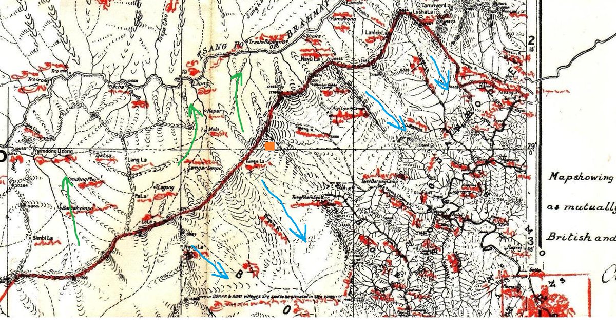
3) To understand where McMahon is coming from, one needs to understand what a watershed is, and what the main Himalayan crest is.
Streams marked in blue here primarily flow to the windward side here & green to the leeward. Can you already make out a diving line for most parts?
Streams marked in blue here primarily flow to the windward side here & green to the leeward. Can you already make out a diving line for most parts?

4) There are two lines here that vary & need to be understood
Yellow: Line by the Indian Gov. (SoI) that largely follows McMahon but doesn't interpret it best, nor have good terrain resolution
Red: Reflects U.S. geographer's interpretation of McMahon. Better representation.
Yellow: Line by the Indian Gov. (SoI) that largely follows McMahon but doesn't interpret it best, nor have good terrain resolution
Red: Reflects U.S. geographer's interpretation of McMahon. Better representation.

5) Let us skip Namka Chu & Longju areas as they're anomalies & deserve their own threads.
Dropping from Bum La ridge, the line follows the highest crest down into Tsona Chu & up to Tulung La- Gori Chen. Crests/ ridges on the map are visible as small contours.
Dropping from Bum La ridge, the line follows the highest crest down into Tsona Chu & up to Tulung La- Gori Chen. Crests/ ridges on the map are visible as small contours.

6) Across Kra Daadi & Kurung Kumey, the ridgeline is marked and there aren't many issues here. The watersheds are also evident.
It is good to get a hang of McMahon's original map now because we'll need it later when terrain accuracy gets muddy.
It is good to get a hang of McMahon's original map now because we'll need it later when terrain accuracy gets muddy.


7) Heading into Siang from Subansiri the water parting line holds strong acc. to McMahon. Northern waters flow into Tsangpo, while southern into Siang's basin.
But what do we see on Indian Govt.'s maps? Here emerge first clear signs of terrain inaccuracies.
But what do we see on Indian Govt.'s maps? Here emerge first clear signs of terrain inaccuracies.

8) Recently reports claimed that China was constructing 琼林 (Qiongling) village "inside Indian territory". Did it?
SoI's line lacks resolution & interprets McMahon wrong. Look at the map on the right. Does the village lie south of the ridge? No.
US line does a better job here
SoI's line lacks resolution & interprets McMahon wrong. Look at the map on the right. Does the village lie south of the ridge? No.
US line does a better job here

9) Moving on to the most messed up part: Dibang
McMahon is again VERY clear that the line passes through the crest separating south & north flowing tributaries.
But, call it inaccessibility or laziness, the boundary shape doesn't adhere to the terrain reality.
McMahon is again VERY clear that the line passes through the crest separating south & north flowing tributaries.
But, call it inaccessibility or laziness, the boundary shape doesn't adhere to the terrain reality.

10) While the US geographer's line understands McMahon (follow the water parting crest!), the Indian Govt's line weaves in & out of valleys randomly.
This is an unrealistic border to hold on ground & does not adhere to the meaning of what McMahon is trying to tell.
This is an unrealistic border to hold on ground & does not adhere to the meaning of what McMahon is trying to tell.

11) Compare the Chimdru & Emra basins clearly marked on McMahon's map tweet #9.

12) In recent years, PLA were spotted crossing Zikyen La & making presence in the Nyam twin lakes area.
This is why one should be cautious using SoI's line (yellow) while claiming newly built villages. Here, using it legitimizes Chinese patrol to what actually is Indian side.
This is why one should be cautious using SoI's line (yellow) while claiming newly built villages. Here, using it legitimizes Chinese patrol to what actually is Indian side.

13) The Fishtails
The most baffling issue in Dibang is where did these 2 indents called Fishtail 1 & 2 come from?
McMahon shows two large valley streams flowing into the Zayül Chu. In reality, it is several smaller streams running from a clear parting ridge into Zayül.
The most baffling issue in Dibang is where did these 2 indents called Fishtail 1 & 2 come from?
McMahon shows two large valley streams flowing into the Zayül Chu. In reality, it is several smaller streams running from a clear parting ridge into Zayül.


14) Now here's the settlement of Thoyu/ Thoyül. It is even marked on Chinese maps today. Does one see a huge valley as drawn by McMahon? No.
Does McMahon still adhere to watershed? Yes. Now, you can imagine the 'fishtail' vanish on a real terrain map.
Does McMahon still adhere to watershed? Yes. Now, you can imagine the 'fishtail' vanish on a real terrain map.


15) GoI (Govt of India) still has such a line as "McMahon" border map, officially.
Now, if we use this SoI border used to determine intruding villages, most Chinese intrusions into the Dibang basin will be given a clean chit, thus India losing what is hers by her own definition
Now, if we use this SoI border used to determine intruding villages, most Chinese intrusions into the Dibang basin will be given a clean chit, thus India losing what is hers by her own definition

16) Mr. Tapir Gao has rightly raised this issue earlier. Will it be drawn? How will it be drawn? We do not know.
Now, zooming in a bit on Chaglagam......
eastmojo.com/news/2020/02/0…
Now, zooming in a bit on Chaglagam......
eastmojo.com/news/2020/02/0…
17) Remember the red line is the water parting & the yellow SoI's line.
PLA patrols have been known to cross Hadigra & Glei passes, coming close to the yellow line. IA patrols also go up to the red but posts remain within yellow. Do you realize the fallacy of using SoI's line?
PLA patrols have been known to cross Hadigra & Glei passes, coming close to the yellow line. IA patrols also go up to the red but posts remain within yellow. Do you realize the fallacy of using SoI's line?
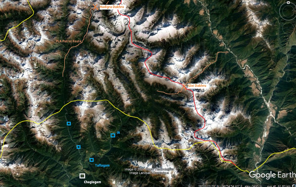
18) Suspected PLA intrusion sites in Chaglagam (best guess, not confirmed).
It seems like IA isn't willing to build a permanent post beyond the yellow line yet. It should technically be at red. Using SoI yellow line on reports in other regions means conceding a large area here.
It seems like IA isn't willing to build a permanent post beyond the yellow line yet. It should technically be at red. Using SoI yellow line on reports in other regions means conceding a large area here.

19) Coming to Subansiri, the line takes a diagonal deviation from the actual main crest near Asaphila to accommodate for Tibetan holy sites of Tsari Ringkor (Takpa Shiri on map), ending at Longju.
Please refer to en.wikipedia.org/wiki/Longju for more
Please refer to en.wikipedia.org/wiki/Longju for more

20 A few others have also written about Longju's history, so I will not delve much into it.
i)
ii)
i)
https://twitter.com/Kautilya33/status/1460341123998789640
ii)
https://twitter.com/KesariDhwaj/status/1457330345141936137
21) As for Namka Chu, it is not very clear where the line passes through, as the terrain on map is highly simplified.
Namka Chu & Asaphila apart, McMahon is pretty clear on the watershed. India must ensure this is maintained.
Namka Chu & Asaphila apart, McMahon is pretty clear on the watershed. India must ensure this is maintained.

22) I hope we're more aware of what McMahon was actually trying to tell us through his maps & SoI takes cognizance.
The govt. might already have their own maps, but the media & politicians also need to be aware before putting out claims 😊 Fin 🧵
The govt. might already have their own maps, but the media & politicians also need to be aware before putting out claims 😊 Fin 🧵
https://twitter.com/NatureDesai/status/1454717464793681922
• • •
Missing some Tweet in this thread? You can try to
force a refresh


