Posted by others, at 0.10 that sound.
Shows fog.
Pakistani were firing, through LTTE in these dense forest and hill area😏😏
Audio just stopped.
Black box found #BipinRawatHelicopterCrash
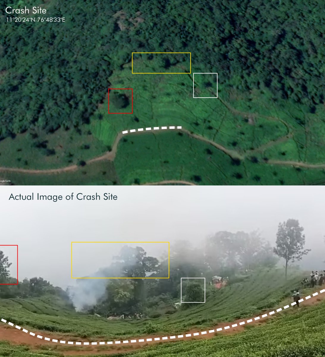
Hope by today this location will be posted. Things will be clear by than. Somone is working on this. If anyone has GPS Corrdinates of crash site it will help.
Train track and other locations are cracked by our associate member @freakingbeast_ please follow him and
@in20im @viper202020 @sayareakd @Lone_wolf110

This was challenging, despite help from Google. We will post it soon.

• • •

Missing some Tweet in this thread? You can try to force a refresh
 

Keep Current with DFI Lite

DFI Lite Profile picture

Stay in touch and get notified when new unrolls are available from this author!

Read all threads

This Thread may be Removed Anytime!

PDF

Twitter may remove this content at anytime! Save it as PDF for later use!

Try unrolling a thread yourself!

how to unroll video
  1. Follow @ThreadReaderApp to mention us!

  2. From a Twitter thread mention us with a keyword "unroll"
@threadreaderapp unroll

Practice here first or read more on our help page!

More from @DfIlite

9 Dec
Location of crash site #BipinRawatHelicopterCrash, location of rail track from where video was made at Nilgiri Railways, height of location etc all thanks to @freakingbeast_ amazing hardwork from him.
It beings in clearity now.
#BipinRawatHelicopterCrash
Location of the video from railway track
Read 8 tweets
8 Dec
An Army helicopter with four people on board, including Chief of Defence Staff General #BipinRawat, crashed in Tamil Nadu's Coonoor today.
3 people have been rescued so far while a search is on for the 4th
The 3 who have been rescued suffered serious injuries
More videos
Another video
Read 23 tweets
25 Oct 20
Now comes the satellite pics of the F`16 crash site. This is 27th Feb 2019 pic, only one which is available. This image is not processed. On right side of the black dot, you can see the yellow cloud type thing.
We than proceeded this image. It shows the depth of this F16 crash site. We compare it before and after pics of the area.
Here is before, on and after satellite pics of the area. Check it out. On 28th Feb, they tried to hide the debri.
Read 9 tweets

Did Thread Reader help you today?

Support us! We are indie developers!


This site is made by just two indie developers on a laptop doing marketing, support and development! Read more about the story.

Become a Premium Member ($3/month or $30/year) and get exclusive features!

Become Premium

Too expensive? Make a small donation by buying us coffee ($5) or help with server cost ($10)

Donate via Paypal

Or Donate anonymously using crypto!

Ethereum

0xfe58350B80634f60Fa6Dc149a72b4DFbc17D341E copy

Bitcoin

3ATGMxNzCUFzxpMCHL5sWSt4DVtS8UqXpi copy

Thank you for your support!

Follow Us on Twitter!

:(