
🧵Apropos recent events, let's take a few minutes to spare a thought for Lepers in 16th century Edinburgh who lived an incredibly strict life of lockdown. 👇 

There was a leper hospital in Edinburgh from medieval times, but there's no hard record as to where it may have been. The "Liberton" = "Leper town" thing is a myth as the place name predates the arrival of the word Leper into Scots language by centuries.
No, Edinburgh's 16th century leper hospital was in Greenside, outside the city boundary at the time (and actually in the barony of Restalrig). The approximate location was between the London Road roundabout and Greenside Church.


We know this not only because it's on old OS maps, but there are surviving records, a contemporary illustration and archaeological evidence from the tram works, where a boundary wall and burials were uncovered.
The use of this site goes back centuries before the hospital. Its first recorded use was as the site of the "Rude Chapel"
The "Rude" refers either to the Rood Screen, a feature of medieval churches, or to nearby Holy Rood. The chapel may have been founded around 1456 when King James II gave the valley of Greenside to the town as a "sporting" field (for medieval sorts of sports).
Little is known of the Rude Chapel, not even which saint it was dedicated to and it probably fell out of use. However in 1518, James Hamilton, Earl of Arran and city provost conveyed it to the "Order of the Brothers of the Blessed Virgin Mary of Mount Carmel"
That is the Carmelite order, or the White Friars on account of their white cloaks. The picture is from 1430 by Filippo Lippi, "Cconferimento della Regola del Carmelo".

The Carmelites were established in the Lothians with friaries at Linlithgow and South Queensferry, and it was the latter which Greenside fell under the patronage of. George Hutton's sketches of the late 18th c. give us an idea of what the latter looked like before repair (NLS)

The friars of Greenside probably ran some sort of hospital along medieval lines, where care was based on Biblical lines and was primarily charitable and spiritual, to prepare the soul for the next life, rather than what modern eyes would recognise as medical
In 1534 two Protestant heretics, David Straiton and Norman Gourlay were condemned to be burnt at the stake. This gruesome sentence was carried out at the the friary.
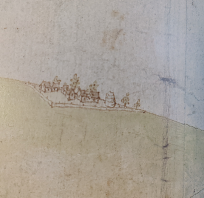
The friary was out of use by the time of the reformation, as in the only confirmed contemporary image it is roofless. It was possibly burnt by the English during the "Rough Wooing" of the 1540s. It is the 1560 Siege of Leith map which records it as the "Roode Chapel"


It is probably also shown on the 1540 map by English military engineer Richard Lee of the Burning of Edinburgh (who may have also made the 1560 map), tucked on the reverse slopes of Calton Hill, a cluster of buildings with a tower that may be a doo'cot (pic © BL)

Anyway, by the 1580s the friary and chapel were abandoned and the city was casting around for a site to build a leper hospital. "St. Paul's Work", a charitable house in the Waverley Valley next to the Trinity College Kirk was mooted, but this was found to be unsuitable
In 1589 the Magistrates of the city approved that a Leper House was to be provided in the former Rude Chapel / Carmelite Friary of Greenside. This was financed by John Roberstson, a wealthy merchant of the city, in response to his prayers for an act of mercy being answered.
The hospital provided for seven inmates, and inmates was the right word as although they were admitted voluntarily, this was a hard bargain and the price of admittance was forfeiting nearly all of their rights as individuals.
These 7 inmates were "Robert Mardow, James Garvie, Johnn MacRere, James Wricht, and Johnn Wilderspune". Also incarcerated (voluntarily) with them were two of wives; Isobel Barcar (Mardow) and Janet Galt (Garvie)
The inmates had to abide by the strict rules of the hospital on penalty of death. To underline the seriousness of this threat, there was a gallows erected on the gable end of the hospital, and the keeper had power of carrying out that sentence on the spot for any infraction.
The inmates were forbidden to leave the hospital, except the two wives (who were not Lepers) and they could do so only on market days to shop for themselves and the patients. And they were forbidden to do anything else outside the walls of the hospital.
The doors of the hospital were to be kept locked from sunset until sunrise. The patients had the "privilege" during the hours of daylight to sit at the door, one at a time, in turn, and shake "ane clapper" to attract the attention of passers buy to donate alms.

Lepers didn't ring bells, they had wood and leather clappers that they shook. These are commonly seen in medieval illustrations. The inmates at Greenside were forbidden from begging under any other circumstances and in any other manner than this.

There were no holidays for the hospital and no visitors were allowed within its walls, apart from those "placit with thame thairin at command of the said Councall and Session".
The alms collected from the door were to be shared equally and declared to the council on a weekly basis when the appointed keeper made his visit. In addition to this a pension of 4 shillings Scots (4 English pence) was provided.
The only comfort provided for them beyond this (and it would have been an important one at the time), was the appointment of "ane ordinair reider to reid the prayeris everie Sabboth to the said lepperis". Every Sunday somebody would come to read them prayers.🙏
So it's clear that the Lepers and their wives basically were locked inside the hospital on their own, to care and provide for themselves as best as they could, and saw only the weekly visit of their prayer reader and council clerk.
There's also every chance that not all of the Lepers even had leprosy, any severe illness of the skin may have gotten you admittance to Greenside.
After this point the hospital seems to disappear from record, and it may have been that it only existed for what remained of the lives of its initial residents.
The 2013 excavations at London Road roundabout for the Tram scheme uncovered remains of a graveyard in this area. The writeup does not mention precise dating or any signs of leprosy on the skeletons, but pottery dated the interments from 15th-17th century.

The Greenside Well is believed to date back to the time of the chapel / fiary / hospital (and may indeed have been the reason they were established at this location) and existed until well into the 19th century


And in a very odd hark back to the distant past, until the 20th century the Catholic Church in Rome still had an official on its payroll who was "il Padre Priori di Greenside"; the Priory Father of Greenside. ✝️
• • •
Missing some Tweet in this thread? You can try to
force a refresh


