
My recent publication is about German security doctrines, Nazi military culture and Hitler’s Luftwaffe. It was published September 2021, and endorsed by the leading academics in the field. 


The book explains why Hermann Göring planned to incorporate Białowieża Forest (Poland) in the masterplan for a Greater German Reich. The forest lay within the region of Bialystok incorporated into Germany. A map, with thanks to @LivUniPress was included on page 22 of the book.

This book represents the next phase in a body of research that began with the PhD (1997), the first book (2008) and several articles (refer to my @academia page) including the journal of Holocaust and Genocide Studies (2010) @HolocaustMuseum .


Białowieża Forest was occupied by the Nazis in June 1941. Today, this remarkable forest is divided between Poland and Belarus. Under the Nazis, the region was part of a plan to realise an old Germanic ambition of a primeval forested eastern frontier.


Advanced methods to raise historical research above the swamp. The book examines German security warfare, and Nazi military culture, through advanced GIS-mapping techniques. The maps focus on the movements of individuals, small units and victims. (@USNatArchives @BundesarchivD )

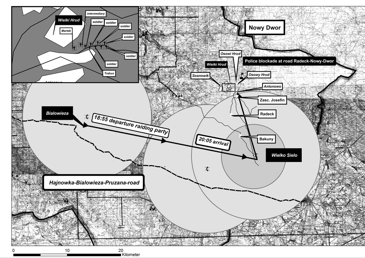
In the the swamp, combat reports are vague/incoherent. Add a GIS-map and the destruction of Luftwaffe-Jagdkommando Marteck is explained. In that case: poor leadership, poor terrain/enemy assessment and lack of control in the attack. A GIS Map from p.348 of the book.

Rising above the swamp was one aim, proving how leading Nazis were directly implicated in genocide was another. Reconstructing a trail of evidence, with pre-1945 documentation ONLY, was essential to undermine postwar claims of a clean Luftwaffe. (@USNatArchives)


This evidence showed Göring’s Luftwaffe commanders and inner circle had been active in perpetrating genocide and participated in the Holocaust. Photographs from the book courtesy @BundesarchivD and @USNatArchives


Analysing the ill-treatment of victims represented a series of challenges. Local Polish/Belarus civilians were literally herded out of the region to transform the frontier of Hitler’s Greater German Reich. (@USNatArchives)


In GIS mapping format, this was about creating clarity. Clusters of 10,000 victims from two waves of deportations were identifiable as per location. The black circles from the 1941 deportations, the red from 1942. Work mapsnot included in the book.


A more difficult task was to track and map partisans and Jews. Jewish victims were particularly difficult to map because they were escaped fugitives from camps and ghettos. They were hunted with particular savagery by the Luftwaffe hence scattering.

The research and GIS mapping revealed the Luftwaffe troops, while undergoing operational training, adopted Auftragstaktik methods to be more effective killers. This places a darker spin on the behaviour of ordinary soldiers in Nazi Germany and the Holocaust.
Mapping dead soldiers was essential to illustrate the levels of violence. Identifying and tracing ordinary troopers was not to empathise with them, but to examine how they became killers. In effect isolating the pre-1945 reality from the postwar myth. (PWB)


The next phase of research - 2 books. An essay collection about the trajectory of security warfare beyond 1945. The subject matter will start with the failed Bandenbekämpfung trial at Nuremberg and will conclude with an essay about the War on Terror. (@USNatArchives).


And a book about Białowieża Forest under German military occupation in the Great War. The 1902 Russian map of the forest courtesy of the Mammal research Institute, Białowieża, Poland. This map was used for a German map in 1915.

A temporary title ‘Journeys into Darkness’. Questions underpinning this research concern the relationships between genocide, sustainability and security.
A similar structure of work is expected.
A similar structure of work is expected.
An example linking literature to analysis. GIS will examine a range of issues including: colonisation, climate, hunting, forestry, geology, wild game, genocide and politics of violence. Example GIS at work - Germans officer’s hunting clusters 1915/16 season.


Thus far, my research has exposed the genocidal purpose underpinning Nazi Bandenbekämpfung, explained the relationship between hunting and German military culture post-1848, and revealed how Auftragstaktik raised killing effectiveness in ordinary soldiers during the Holocaust.
The future research will aim to conclude with an examination of the impact of economic sustainability on national security, and the origins of Auschwitz.
• • •
Missing some Tweet in this thread? You can try to
force a refresh


