LONG THREAD: Since 1987, India has assessed its forest cover every two years in its India State of Forest Reports (ISFR), produced by the Forest Survey of India (FSI). The 17th ISFR was released three days ago.
Here I take a closer look at the entire stack of ISFR reports…
Here I take a closer look at the entire stack of ISFR reports…


The ISFR reports present lots of stats, but in this thread, I focus on the headline statistic: trends in India’s total forest cover over time.
So, let’s go… here, in one graph, is a 35y summary of the official line on our forest cover: from 1999, it has been nonstop good news.
So, let’s go… here, in one graph, is a 35y summary of the official line on our forest cover: from 1999, it has been nonstop good news.

India’s forest cover declined until 1997, after which it rose an whopping 45,000 km² over the next three reports. Two key changes in 2001 contributed to this: FSI adopted a fully digital analysis workflow, and it dramatically changed its definition of a forest (more on this soon)


TL;DR: despite ISFR claims of rising forest cover, there is little evidence to show that India's natural forest cover has actually increased; in fact, it has very likely declined. The purported gains are largely come from FSI’s problematic and perverse redefinition of 'forest'.

The ISFRs, bizarrely, not only report forest cover for a new assessment year, but often go back and tweak forest cover values of previous years. In 2005, they reduced the 2001 estimate c. 22,000 km² (6x Goa’s land area!). In 2009, they hiked the 2005 estimate by c. 13,000 km².
The FSI’s logic for such ‘harmonisation’ is vague, at best. Technological + methodological changes upsold in 2001 as improvements in accuracy—yielding a 38,000 km² increase in forest cover—get casually brushed off as wrong interpretations in 2005, leading to a 22,000 km² decrease


Now, let’s see how the ISFR numbers in the report stand up to closer scrutiny.
Let’s take Sonitpur in Assam, where rapid and huge forest losses occurred between 1997 and 2007. Surely, the ISFRs, claiming high accuracy of forest cover estimation, should’ve this nailed, right?
Let’s take Sonitpur in Assam, where rapid and huge forest losses occurred between 1997 and 2007. Surely, the ISFRs, claiming high accuracy of forest cover estimation, should’ve this nailed, right?
Nope! If you pull out the numbers on forest cover for Sonitpur District from ISFRs, they show an utterly mystifying increase in forest cover in the district during a period when the devastating forest loss it experienced is plainly visible in publicly-available satellite imagery.
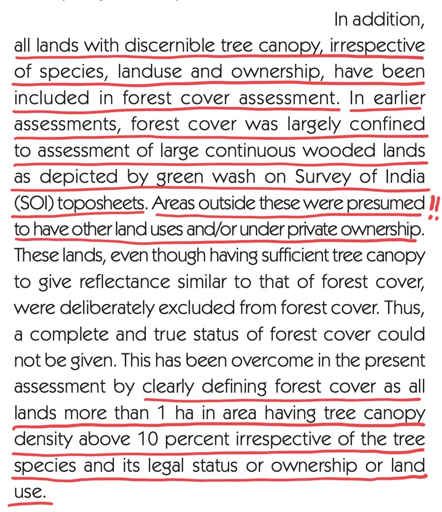
So, what are the ISFRs counting as forest cover to generate their flattering figures? Besides technical changes made to satellite imagery analysis, in 2001, the FSI completely rewrote the definition of a forest: so long as a mere 10% of a hectare of land had trees, it was forest.
That the new definition of forest would lead to an increase in areas being counted as forest was clear. But what land cover types might it include on the ground, or how valid was their inclusion as forests, remained extremely hard even for experienced field researchers to assess.
This is because the ISFR, despite being publicly-funded, has NEVER EVER released its maps publicly. It’s critical to see here that maps—and not the reports—are the real, verifiable data from the ISFR assessments. Reports are mere dossiers of FSI’s claims on what the data contain.
I have tweeted earlier about the travesty in the FSI selling its publicly-funded assessment data at a ludicrous price of ₹2,000 per 1°x1° tile, per assessment. If available at all, at this price, the entire time-series data stack would cost upwards of ₹ 50L to buy!
https://twitter.com/mdmadhusudan/status/1183255434880147456
Significantly, FSI continues to hold out and not part with its map data, making complete mockery of an extremely progressive geospatial map data policy recently put out by the Government of India.
See: dst.gov.in/news/guideline…
See: dst.gov.in/news/guideline…
Thankfully, another GoI website recently publicly put out map data from a recent ISFR assessment. In over 25 years of trying in vain to steal a glance at a forest cover map produced by FSI, I was finally able to see for myself what it looked like!
Looking at Sonitpur on the FSI map, it turned out that their report was counting thousands of hectares of private tea gardens around Rangapara as forest.
But could this be an excusable, one-off lapse? Let’s see if the map does better in other tea areas…
But could this be an excusable, one-off lapse? Let’s see if the map does better in other tea areas…
In Naxalbari of West Bengal too, the ISFR treats tea estates as forest. Not just that, they also designate some tea as Open Forest, some as Moderately Dense Forest, and some tea and human settlements as Very Dense Forest. Not good, but let’s continue…
In Valparai of Tamil Nadu, nearly 2,000 km away, again, tea is counted as forest. In a landscape where priceless wet-evergreen forests were destroyed some 150 years ago to plant tea and coffee, it is beyond ironical that India is now calling the tea estates themselves as forest!
A little to the north of Valparai, an intensive agricultural landscape around Pollachi town dominated by coconut is almost entirely counted as forest. Again, a large fraction of these coconut areas are classified as Moderately Dense Forests.
It should come as no surprise at all then that the remote islands of Lakshadweep, with little other than coconut trees and human dwellings, leads the nation in forest cover, with > 90% of its land area under forest, while also supporting over 2,000 people per square kilometre!
If densely settled areas as Kavaratti in Lakshadweep are forests, we must surely check for forests that might be lurking in plain sight in our metros. Sure enough, here’s one in Kolkata: all it takes are a few dozen trees in a heavily built-up area for the FSI count it as forest.
Turns out, the very abodes and workplaces of India’s highest constitutional functionaries too are ensconced in the Open to Moderately Dense Forests of Lutyens Delhi. Which would make our leaders forest dwellers, right?
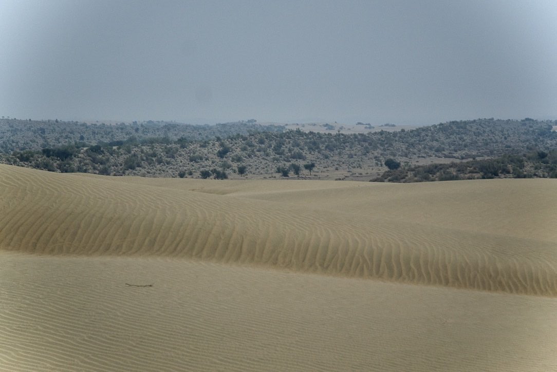
On a total lark, I decided to look for forests in the deserts of Jaisalmer. And found them too! Whatever else our criticism of the FSI, they certainly can’t be accused of favouring only tree-clad areas in counting India’s forests.
Finally, I looked at areas of Kutch, where Prosopis—one of the world’s worst invasive plants—has taken over open natural ecosystems. Sure enough, the FSI was generously counting this invasive from faraway lands—and a biodiversity conservation nightmare for India—also as forest.
Are these egregious examples of forest cover “wrongly interpreted” on account of “radiometric and geometric errors of satellite data”?
Unlikely.
See how much better maps of the National Remote Sensing Centre (NRSC) are at telling natural forests from tea and coconut.
Unlikely.
See how much better maps of the National Remote Sensing Centre (NRSC) are at telling natural forests from tea and coconut.
So, from all available evidence, it would seem that the ISFR’s counting of tea gardens, coconut plantations, built-up areas, and even desert scrub, as forest is no accident. It seems a rather considered and deliberate stance. But how does such a stance even make sense?
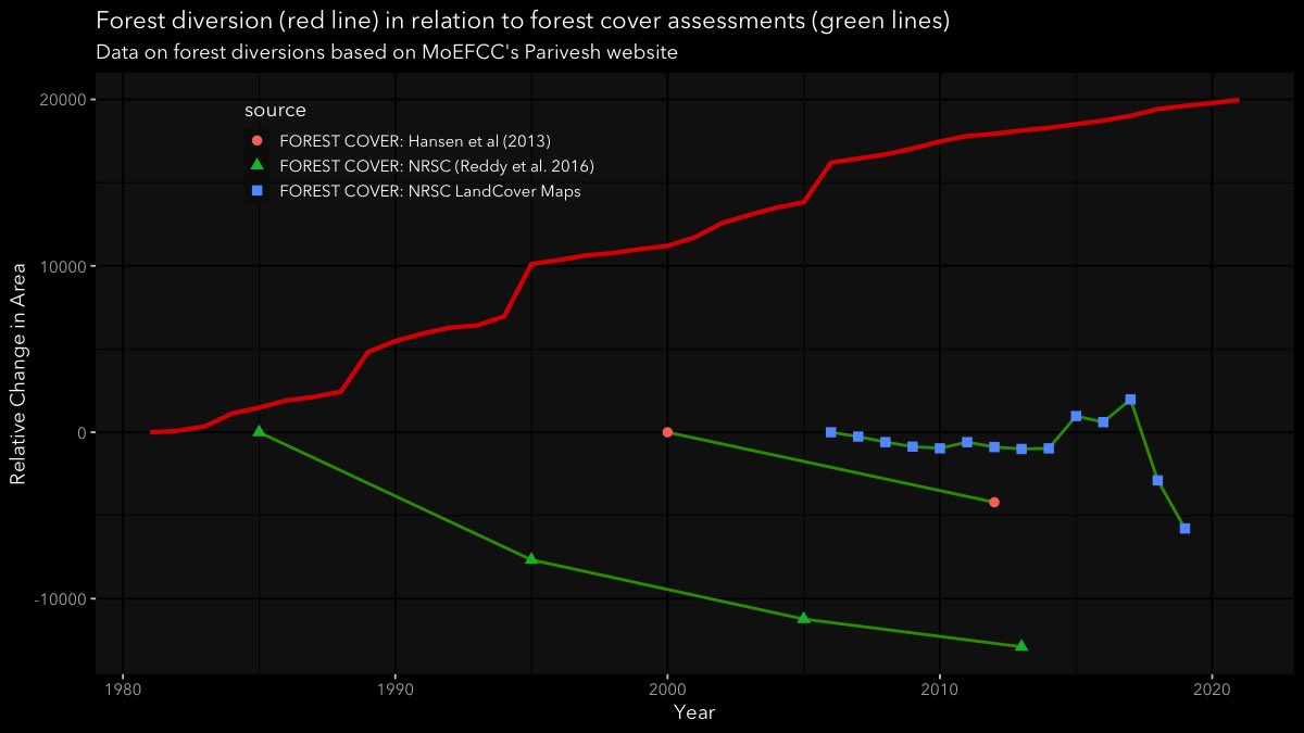
FIRST: every government wants to divert forests for energy, infrastructure and industry. To do so even when forests are in decline is publicly indefensible. Instead, by redefining forests to include various human land-uses, we ensure that both forest cover and diversions can rise

Who could be against an increased diversion of forests if it can be shown that forest cover too is increasing? This, in fact, seems to be the one chart that our MoEFCC has been standardising regardless of who is in power.

On the other hand, alternate assessments of India’s forest cover from sources that are institutionally more independent (than the FSI is from the MoEFCC) present a very different picture: rising forest diversions, unsurprisingly, seem go with declining natural forest cover.
SECOND: a large and rising forest cover offers bright prospects in global carbon trade, where countries adding forest cover could trade their carbon gains to offset emissions of other countries for money. And yet, our story hasn’t been easy to sell. 👇🏽
business-standard.com/article/curren…
business-standard.com/article/curren…
But, so what?
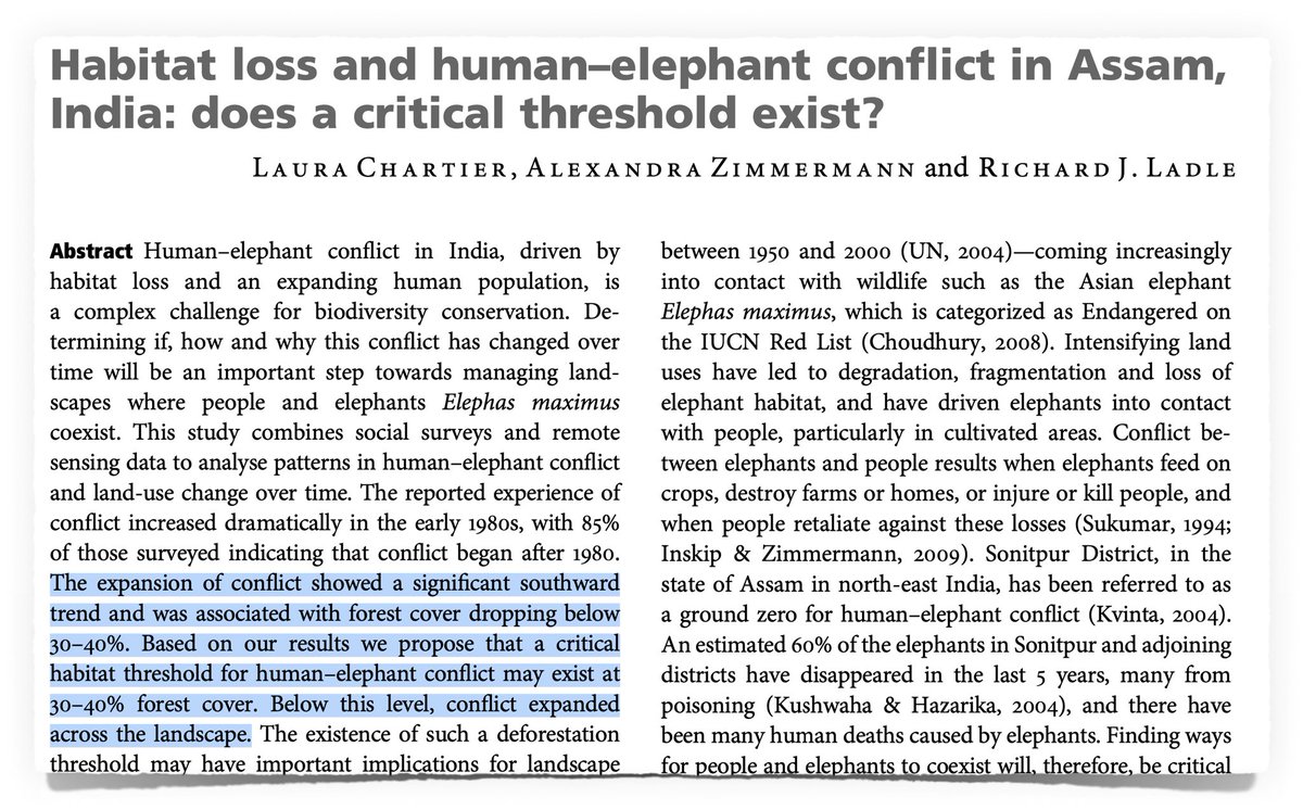
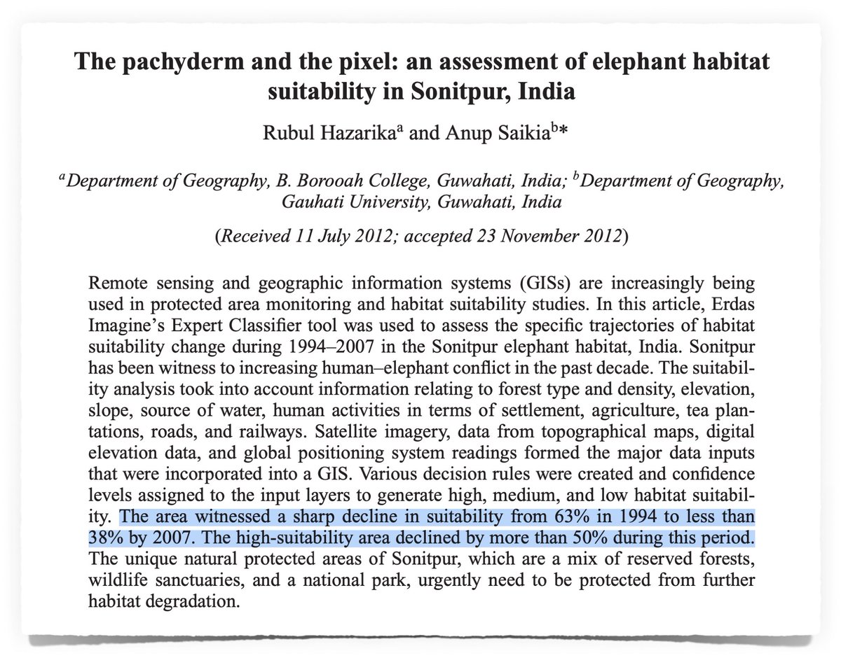
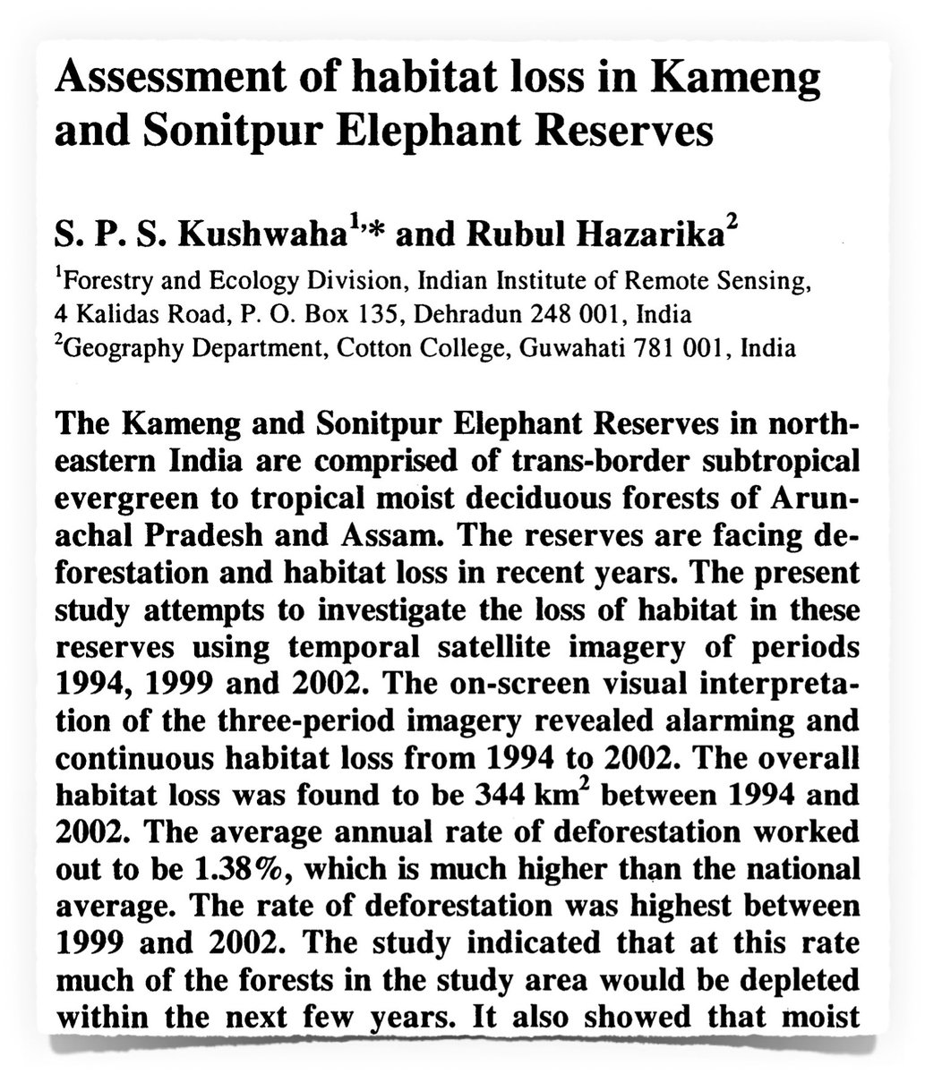
Natural forests hold vaster and more varied values to biodiversity and communities than any land cover created by humans. See what has happened in Sonitpur following its catastrophic forest loss: both elephants and humans are locked in a worsening conflict.
Natural forests hold vaster and more varied values to biodiversity and communities than any land cover created by humans. See what has happened in Sonitpur following its catastrophic forest loss: both elephants and humans are locked in a worsening conflict.
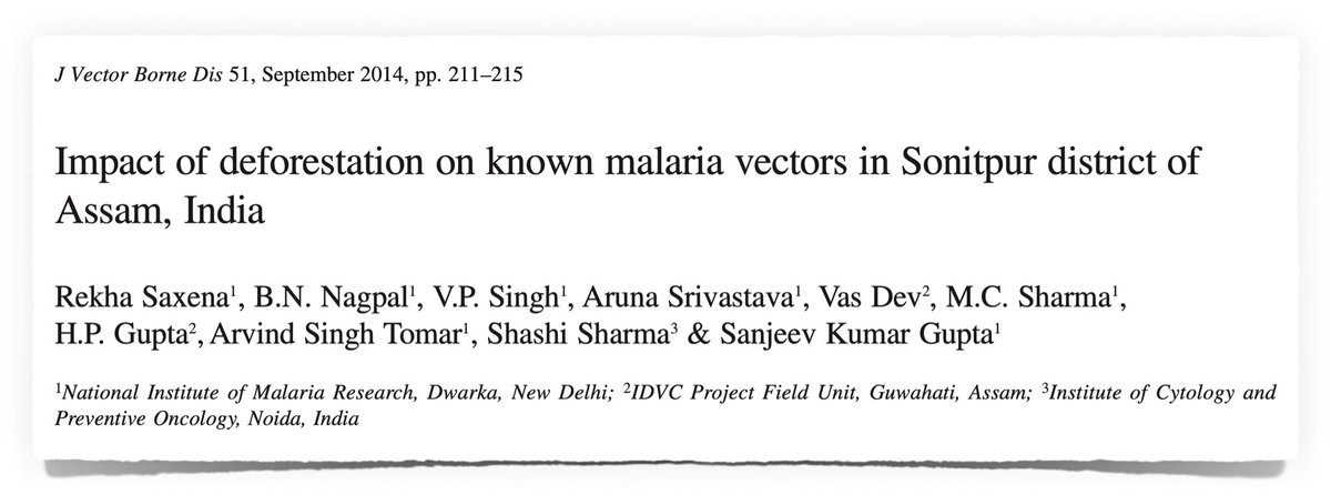
Further, in the midst of a pandemic, we must also recognise that the loss of natural forests in Sonitpur had catastrophic downstream effects on human public health, with malaria rising eight-fold in areas that had experienced forest loss.

Neither of these serious consequences for wildlife and people are ever averted by redefining forests or by massaging numbers. We must recognise, count and value natural forests as such, and our tea-estates and tree covered boulevards for what they are: tree-clad non-forest areas.
Forests are a public resource.
And reliable civic data—especially on key indicators such as natural forest cover—are a public good.
To thrive, every society needs—and must demand—more and better of both.
(END)
And reliable civic data—especially on key indicators such as natural forest cover—are a public good.
To thrive, every society needs—and must demand—more and better of both.
(END)
• • •
Missing some Tweet in this thread? You can try to
force a refresh