Forensic Architecture Profile picture
Feb 2, 2022 13 tweets 8 min read Read on X
1/ In 2020, Parvin, a young woman from Iran, crossed the Greek-Turkish border 7 times; 6 times across the Evros/Meriç river and once over the Aegean Sea. She was arrested and pushed back 6 times. We worked w/ @ECCHRBerlin, @rights360 and Parvin to reconstruct her journey.
2/ Parvin recorded her first 3 crossings through photos, videos, audio messages & live location sharing. Unprecedentedly, she was able to record videos from inside Greek border guard stations that revealed the cell interiors & conditions of detention, all previously undocumented.
3/ Analysing this evidence, we found that she was held in four Greek Border Guard stations: Neo Cheimonio BGS, Iasmos BGS, Tychero BGS, and Soufli BGS, twice.
4/ Before her first pushback, in Neo Cheimonio BGS Parvin was tortured by officers and received death threats. Using her testimony, her videos, found footage, and satellite imagery we created a 3D model of the BG Station and positioned her recollections in space.
5/ Before her second and sixth pushbacks, at Soufli BGS Parvin was held for hours on end with numerous other people in a container without aeration or a toilet. We located this container in the parking lot of the BGS, exactly where she remembered it.
6/ During her third pushback, at the Kastanies/Pazarkule border fence in late February 2020, Parvin was tear gassed and shot at, and became an early witness to the violent March 2020 events which would leave at least two dead, Muhammad al-Arab and Muhammad Gulzar.
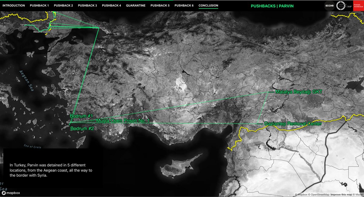
7/ Following her fourth pushback, when she was left adrift in the Aegean Sea by the Hellenic Coast Guard, Parvin was detained in 5 different locations in Turkey, from the Aegean coast all the way to the border with Syria.
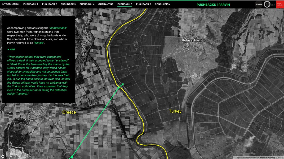
8/ During her fifth & sixth pushbacks through Tychero & Soufli BGS, guards were assisted by men from Afghanistan & Iran. In exchange for not being pushed back themselves, these men—who identified as 'slaves'—had to live in the BGS and ferry other asylum seekers back into Turkey.
9/ Spanning summary expulsions & torture in the Evros/Meriç, apprehensions deep inside GR territory, ‘drift-backs’ in the Aegean & extended periods of detention in TR, Parvin’s pushbacks cover the full spectrum of this violent practice. A thorough investigation is long overdue.
10/ View the full investigation: parvin.forensic-architecture.org
11/ Read the piece by @derspiegel: spiegel.de/ausland/griech…
12/ Follow the press conference with Hanaa Akiki of @ECCHRBerlin, @eleni_takou of @rights360, @MuizNils of @AmnestyEU, @tsitse of @Hellenic_League, and our @LevidisStefanos, today at 11:00 CET: bit.ly/32AFccG
13/ Read the complaint before the UN Human Rights Committee #HRCttee by @ECCHRBerlin & @rights360: ecchr.eu/en/case/bringi…

• • •

Missing some Tweet in this thread? You can try to force a refresh
 

Keep Current with Forensic Architecture

Forensic Architecture Profile picture

Stay in touch and get notified when new unrolls are available from this author!

Read all threads

This Thread may be Removed Anytime!

PDF

Twitter may remove this content at anytime! Save it as PDF for later use!

Try unrolling a thread yourself!

how to unroll video
  1. Follow @ThreadReaderApp to mention us!

  2. From a Twitter thread mention us with a keyword "unroll"
@threadreaderapp unroll

Practice here first or read more on our help page!

More from @ForensicArchi

Dec 12
We’re honoured to announce a major new project supported by @wellcometrust.

UNLEARNING ‘EXCITED DELIRIUM’ brings together a world-class team to confront an urgent health, human rights, racial & social justice issue. Meet our partners below…

unlearnexd.org
The project builds on decades of activism on race and policing by Stafford Scott, of @tottenhamrights and a Guest Professor with FA here at Goldsmiths. The seeds for this project were sown during 2021’s unforgettable WAR INNA BABYLON at @icalondon
ica.art/exhibitions/wa…
In 2022, a major report by @p4hr exposed the racist origins of ‘Excited Delirium’ (ExD). Despite no scientific basis, ExD and its inheritor ABD are still often referred to when racialised men are killed by police.

We’re set to continue PHR’s vital work: phr.org/our-work/resou…
Read 7 tweets
Sep 3
Israel is besieging Gaza City from three directions, pushing the nearly 1m Palestinians currently sheltering there towards southern Gaza.

Each military advance flattens homes and infrastructure in its path, threatening the erasure of millennia-old Gaza City, and displacing the people sheltering there. Most of the areas in southern Gaza which the military have allocated for relocation are within ‘no-go’ zones, or in areas unsuitable for habitation.Image
Israeli troops are advancing towards Gaza City from three directions: Jabalia in the north, Shujaiya in the east, and—most recently—the Netzarim Corridor in the south. This leaves Palestinians with only one place to go: towards the coast, along al-Rashid Road and into southern Gaza.Image
Image
A comparison of satellite images from 9 and 25 August reveals the rapid dismantling of dense tent camps in Gaza City as Israel’s ground invasion has advanced. Meanwhile, tents, homes, markets, and community kitchens in the rest of the city have instead been subject to relentless bombardment, leaving the besieged, starving population with few options but to flee south.Image
Image
Image
Read 6 tweets
Jun 14
NEW: Salman Abu Sitta is a Nakba survivor and historian of Palestine. Together, we digitally reconstructed his birthplace, the village of al-Ma’in, exploring its history and documenting how, in 1948, the village was destroyed and its people forcibly expelled: forensic-architecture.org/investigation/…
On 14 May 1948, al-Ma’in was occupied and demolished by Zionist forces. Image
We reconstructed the village to uncover its layered history — from its vibrant agricultural life, with a 95-metre deep well and a bayarah, to the 60,000 dunams (15,000 acres) of land cultivated by the Abu Sitta family, mostly wheat and barley.
Read 6 tweets
Jun 6
FA has documented a pattern of Israeli attacks on areas into which they have previously instructed civilians in Gaza to evacuate. Our research confirms that the Israeli military carried out multiple attacks in areas towards which civilians had been directed, either on the same day as the evacuation order, or on the day after. See more: frames.forensic-architecture.org/gaza/updates/a…
1) On the morning of 23 Mar 2025, the Israeli military issued an evacuation order for Tel al-Sultan neighbourhood of Rafah, directing civilians to move northeast. That evening, there was an airstrike northeast of Tel al-Sultan, in Khan Younis, that hit the Nasser Medical Complex, the largest hospital in the area.Image
2) On the morning of 7 Apr 2025, the Israeli military issued an evacuation order to Deir al-Balah, directing civilians to move southwest. Later that day, there was an attack on a residential building southwest of Deir al-Balah. The following day, there were two attacks in areas southwest of Deir al-Balah.
Read 6 tweets
Jun 6
Israel has designated the majority of the Gaza Strip for evacuation. 34 evacuation orders have been issued to civilians in Gaza since the dissolution of the ceasefire on 18 March 2025. Many of these orders define differing boundaries for the militarised buffer zone in the east of Gaza, gradually expanding the area designated for evacuation. See more: frames.forensic-architecture.org/gaza/updates/i…
We have documented 4 instances where the declared boundaries of the buffer zone have subsumed areas previously subject to evacuation orders. As of 3 June 2025, the buffer zone has expanded to encompass the municipality of Rafah, as well as areas to the east of Khan Younis and in the north of Gaza.
For example, an evacuation order was issued to the municipality of Rafah on 31 March and 1 April. In an evacuation order issued on 6 April, the declared buffer zone expanded to encompass the areas previously designated for evacuation.
Read 4 tweets
May 16
Israel is constructing a second militarised ‘corridor’ in Gaza, to expand their control of the Strip. Plans for the Morag Corridor were announced on 2 April; since that time, we’ve identified widespread destruction throughout the remains of Rafah city, and several new Israeli military outposts. Follow this developing situation in our new mapping portal: frames.forensic-architecture.org/gaza/updates/m…
A comparison of satellite imagery from 3 April and 11 May reveals how entire areas of central Rafah have been destroyed by the Israeli military.
During the same timeframe, the Israeli military destroyed dozens of buildings and greenhouses, as well as agricultural land, to the north of Rafah, to make way for the construction of the Morag Corridor.
Read 7 tweets

Did Thread Reader help you today?

Support us! We are indie developers!


This site is made by just two indie developers on a laptop doing marketing, support and development! Read more about the story.

Become a Premium Member ($3/month or $30/year) and get exclusive features!

Become Premium

Don't want to be a Premium member but still want to support us?

Make a small donation by buying us coffee ($5) or help with server cost ($10)

Donate via Paypal

Or Donate anonymously using crypto!

Ethereum

0xfe58350B80634f60Fa6Dc149a72b4DFbc17D341E copy

Bitcoin

3ATGMxNzCUFzxpMCHL5sWSt4DVtS8UqXpi copy

Thank you for your support!

Follow Us!

:(