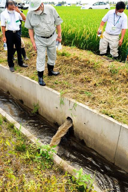
"Rice Paddy Dam" is a concept for river basin flood control that originated in northern Japan around the turn of the century. It uses agricultural land as a sort of reservoir to protect downstream urban areas from flood damage and excessive water, the fields used to store water.
When bad rains are anticipated fields can be emptied prematurely and filled up again in a controlled manner that prevents overflow, erosion and scouring using a system of weirs and channels. Depending on the size of the system it can hold vast amounts of water, millions of tons.
As a bonus, after installation it becomes easier to regulate water in the rice paddies with hugely beneficial effects on flora and fauna. The system is voluntary but many cities are now paying farmers to compensate for any damages to crops and for maintaining the system.
Until last year the major drawback was the manual operation: accidents happened, but now weirs can be remote controlled by individual farmers via a smartphone app. No need to go out in typhoons and risk drowning like before (for millennia a major occupational hazard for farmers).
• • •
Missing some Tweet in this thread? You can try to
force a refresh
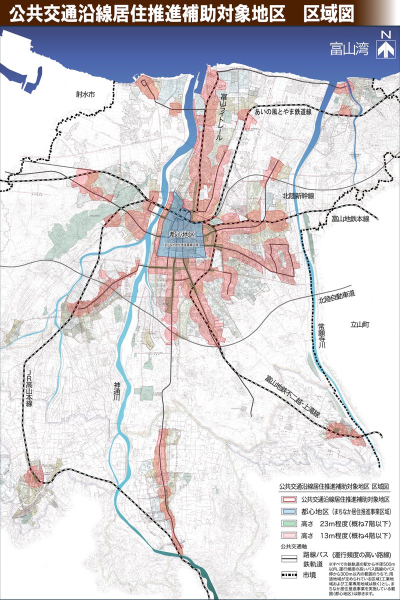
Map of Toyama City's (pop 419k) resiliency project by city densification and public transport improvement: development in red zones* get subsidized (think ca. 1/3 of cost of new build). Target: 45% of pop. bef 2045.
*500m from train/tram.
*300m from high freq. bus (>60 per day).
In 2003 Toyama City was facing skyrocketing infrastructure and social services costs: the population was aging, city trams were losing money, health levels were dropping, young ppl. had little hope for the future. Car dependency was increasing at over 70% but fewer could drive...
...so the mayor decided to promote programs to move people into the city, lessen car dependency, improve public transport & promote healthier more active elderly, lower cost of establishing family. 1. The city center zoning laws were relaxed. 2. New home construction subsidies.
Every building technology is ultimately a compromise. Hundreds of factors weigh in. Faced with similar situations, vastly different cultures will reach the same conclusions: take the thatched roofs of the N. Atlantic Hebrides and those of Jeju Island in the Korea Strait for ex.
Both areas are characterized mostly by strong winds and relatively meager soils. Hence roofs were thatched (which grows amply on poor soils) and built with a low angle (nearly flat) with an oblong shape weighed or tied down with a net of rope to minimize the effect of winds.
Normally the primary purpose of a roof is to shed water but here that job had to take second place: longevity is sacrificed in order to ensure that roofs can survived hurricane or typhoon strength winds. Rain permeates the thatch so in the case of Jeju, they only last 1-2 years.
Went to look at a possible source of thatching materials. This stand was last harvested by a village about a century ago. Unfortunately the soil here is poor in minerals and having been left to grown wild for so long the material is of quite low quality: not worth the effort.
There used to be a village here, growing rice and herbs and vegetables and foraging for food and materials in the mountains. Today all that remains are some old stone foundations and pieces of pottery. This piece comes from a tea cup ca. 17th-19th century. Unearthed by moles.
Another sign of the village that once were: there was a stand of windmill palms nearby. These trees were used to make the rope that thatchers and carpenters needed to build the mostly round timber roofs. Quick and easy the rope lasts for centuries and can be composted at the end.
Cobble-streets perform an invaluable service during flood events. Studies measured them to have a steady infiltration rate of 65mm/h: this means that an average city slope of asphalt (0mm/h) is a rapid river after 30min of heavy rain while a cobble-street would suck it all up.
However, natural forest soils are incredible sponges and can store unbelievable amounts of water during storm events. But run these soils over with heavy forest machinery for a decade or so and the soils gets so compacted it isn't much more impermeable than a city cobble-street.
Some desert soils are so compacted by millennia of grazing animals, wind and rain that they aren't much more permeable than tarmac. Unless you see it for yourself you have no idea how hard desert soil can get.
The future must be sustainable or there will be no future at all. Agroforestry is the practice of combining slow growth forest (which can take generations to mature) with agriculture, solving many practical ecological, technical problems. In Taiwan, agroforestry is growing.
In in Hualien County a private 6ha butterfly reserve is being used to also grow indigo plants, which were a major cash crop until about a century ago. Underneath the trees indigo plants provide food and shelter for the butterflies: excess indigo leaves are harvested and sold.
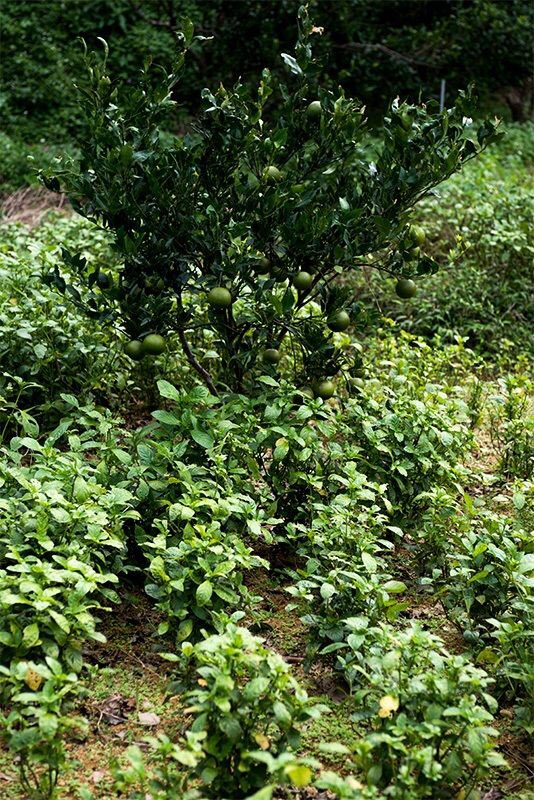
Indigo prefers full sun but in hot climates it grows well in shade. In nearby Okinawa indigo is grown with great success in citrus tree orchards, doubling the output of the farms for very little extra labor and investment.
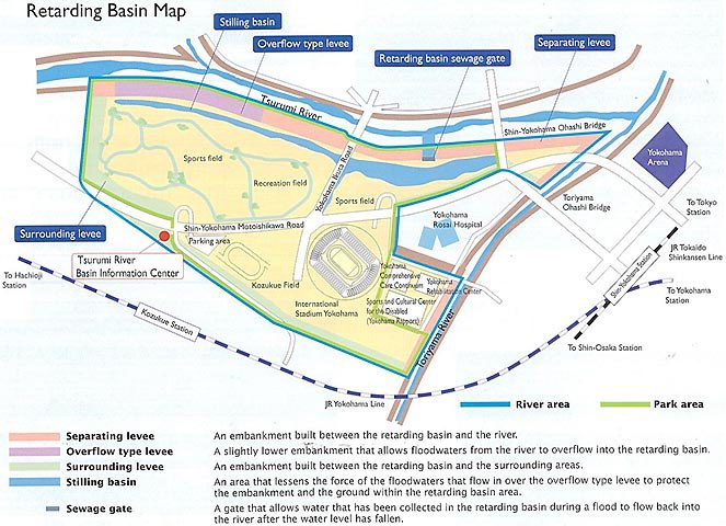
Tsurumi River between Yokohama and Tokyo regularly flooded with devastating results until a new concept was trialed in a huge project started in 1985 and completing in 2003: the Tsurumi River Multipurpose Retarding Basin. Covering 84ha it functions as a flooding control zone.
To call it successful would be an understatement: here's two charts, one of maximum two day rainfall, one of number of flooded buildings. Both cover the same time period. Red line represents the start of construction.
Normally the zone is a park containing a raised stadium and sports facilities as well as nature walks, wildlife etc. During the 2019 mega-typhoon the basin which holds 3.9 million m³ (the equivalent of a power dam) of water received 0.94 million m³, well within its capabilities.