
Sometimes I get asked a question to which I *kind of* know the answer, but want to check on my facts before I respond, and the answer ends up being much more interesting that I thought it might be.
Q. What is it with these steps on West Norton Place?
🧵👇
Q. What is it with these steps on West Norton Place?
🧵👇
https://twitter.com/langrabbie/status/1491900272381210626

So, where we are is in a bit of Edinburgh called Abbeymount, where the top of the Easter Road suddenly starts climbing steeper and in a circuitous manner around the old Regent Road School, up to Regent Road, and then drops right back down the other side towards Holyrood


Why does this road take a rather winding, S-shaped course (green arrow), when logically it should just plough straight ahead at the top of Easter Road, along the cul-de-sac of West Norton Place and through to Holyrood (orange arrow)?

The short answer of course is that it wasn't always this way. In fact it wasn't this way at all prior to 1816. We are going to have to dive back into old Edinburgh via the NLS map library...
Prior to 1800, most cart traffic between Edinburgh and its port of Leith went via the Easter Road and into the city via the Canongate past a tollbar at the Water Yett (or Water Gate) via the little village of Abbeyhill

This was also the principle route to the village of Restalrig (purple arrow) and the route east and south (green) for those brave enough to try a journey by land to London. Both these maps are from Roy's Great Lowland Map of ~1750.

At the turn of the 19th century, the land at Abbeyhill was a small estate known as "Baron Norton's Feu" or "Norton Park". Fletcher Norton was an English lawyer who settled in Edinburgh and established himself in the world of Scottish law and the Edinburgh establishment.

To the south of Norton Park was Abbey Hill itself, a village just outside the city boundary and really just a street of taverns, stables and smithies like you might expect as being needed on the way into town. It only extended to the limits of the green boundary.

In orange is the Upper or Over Quarry Holes, an ancient Edinburgh place with a fascinating history all of its own of trysts, witches, skirmishes, faeries, drownings and duels. But that's for another day. Sorry.

In purple is a little suburb of villas known as Maryfield (from where the current streetname comes) and in blue is the pleasure gardens of Comely Green, a sort of Georgian pleasure park where for a fee you could gather to stroll, court and do fashionable things like drink tea.

Anyway, you're probably already ahead of me and have seen those faint pencil lines on that map and have realised they're very close to the modern street alignment and want to know what they're all about. So let's move on.
At the turn of the 19th century, Edinburgh has a problem. It is ever more renowned for its New Town architecture, its flourishing society and its place as a beacon of learning and enlightenment, but the approaches to this "modern Athens" are rubbish.
Approaching from Leith you can pick your way up the footpath along the line of General Leslie's old 1650s fortifications that will become Leith Walk, or you can take a carriage up Easter Road and enter this grand modern town through its ancient and frankly embarrasing Canongate.
Or if you are coming from London, as you approach Edinburgh you can see little of this renowned new metropolis as your carriage bumps and sways its way past Jocks Lodge into the Canongate by Abbeyhill. Looking out the window you could be back in the early 18th century.
Something had to be done! And who better to do it than that most eminent of Scottish Georgian engineers - Robert "Lighthouse" Stevenson. Stevenson doesn't need many introductions, but his role in shaping and forever changing this end of Edinburgh I hadn't until now appreciated.

The approaches to the city from Leith would be improved by the widening and levelling of the "Walk of Leith" into that road we now call Leith Walk, with showpiece Georgian townhouses built at the top as you entered the city at Picardy Place.
And of course who should live in one of these fine new houses at the head of Leith Walk but the Stevenson clan themselves, at Baxter's Place (cc-by-sa Stephencdickson)

However that was only one part of the improvements. The next scheme was the "Great Post Road from London", the road we now know as London Road or A1. This was proposed from around 1800 and an Act of Parliament made in 1803 for it. You can see the route on this 1804 map.

However the magistrates of the city were unhappy still, as although it create a wide, flat and smooth boulevard worthy of entry into the city, with ample lands to feu off into housing along the way, it meant the arriving visitor had their view obscured by the Calton Hill
The magistrates and Stevenson were also concerned that by entering the city this way, you had to go up Leith Street, and this spoiled the whole point of the wide and smooth approach they were about to spend a lot of money and effort creating.

No, what was needed was an *even* better way into the city. One with breathtaking views of the city as you enter it and with the smoothest and flattest possible route for horse carriages.
The answer was obvious to one Magistrate, William Trotter ("Scotland's greatest cabinet maker") and also to Stevenson. They were going to have to go not around but *over* the other side of the Calton Hill.
It seems the obvious route now that it's been done, but this was a vast engineering challenge. That side of the Calton Hill was known as the "Dow Craigs" and was all rocks and towering cliffs. There was a good reason it had never yet been built on, as this 1796 print shows

That print may be a little earlier than that, as between 1791 and 1796, Robert "Scotland's Greatest Architect" Adam built the city their new jail, "the Bridewell" on the south slopes of the Calton Hill, where St. Andrew's House now stands.

It was William Trotter who had apparently been instrumental in getting the new jail sited here, as the original idea was to put it in the Nor Loch Valley, which anathema to him.
The Bridewell was built with stones hewn out of the Salisbury Crags themselves, and it was this ready supply of stone to which Stevenson would turn to realise this grand scheme for a road around the south of Calton Hill to join the London Road.
We are hugely fortunate that Stevenson's beautiful drawings have survived and have been digitised by the NLS (@natlibscotmaps), and his plans for the scheme are in the collection - see the full thing here maps.nls.uk/view/218519267

There was a problem however, as at that time Princes Street was closed off at its eastern end by a rather humdrum collection of buildings known as Shakespeare Square (where Trotter lived and worked). No problem. Just demolish them as they aren't grand enough anyway.

And down they did come! (pic Edinburgh City Libraries)

Much of the ancient Low Calton was also in the way. Consider it gone (pic Edinburgh City Libraries)

The yawning gap in the city between the end of Princes Street and the Calton Hill, where previously the Burgh of Calton did nestle, was spanned by the Regent Bridge. You don't get an idea of how impressive the bridge is until you see it unhidden by the buildings that enclosed it

This allowed Stevenson to build a wide and straight 1-in-35 incline road from the East End at Register House to a flat summit outside the Bridewell.

From there the road ran relatively straight at a 1-in-26 decline for the 3,000 or so feet down to the new Great London Road. This required a lot of cuttings and bankings as illustrated in his plans.

Stevenson quarried the rock for the bridges, embankments, infill and road surface from Salisbury Crags, needing at least 10,920 cubic yards. Indeed in the 4 years 1815-1819, some 45-50,000 tons of stone were quarried off of the crags for this and other schemes.
It was estimated that each ton of stone won meant 2 more lost in rubble, tipped down the slopes of the crags. Some of this waste was recovered, but such was the alarm caused by the rapid and significant alteration to the Crags that they were never worked again after this.
Work proceeded quickly, and was formally completed in 1821, although the route was passable as early as 1819. Although that's an important part of the story, it still doesn't answer why the area around West Norton Place looks like it does now. We need to keep going.
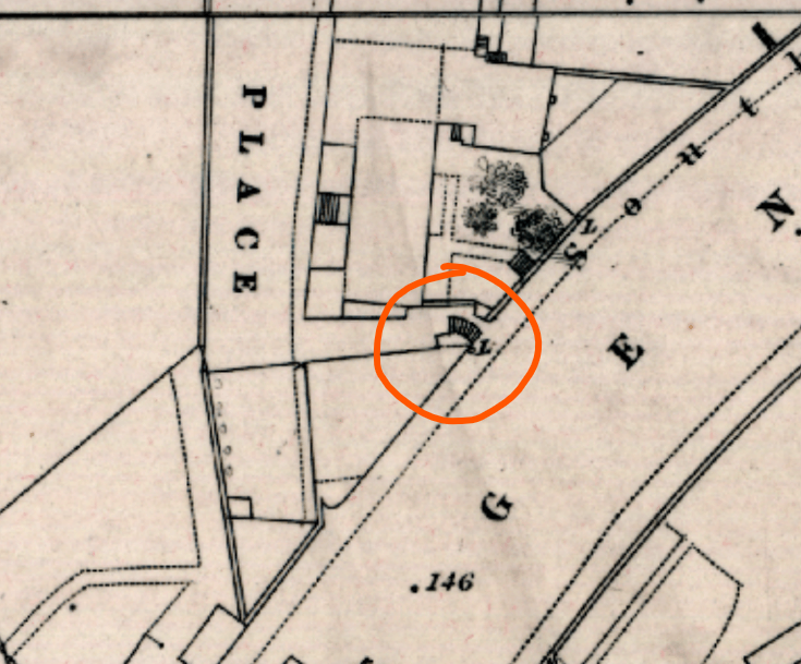
So if you look closely at Stevenson's Plan, something strikes you. There's what looks to be a bridge at Abbeymount.

Yes, there's definitely a bridge. It's not a very big bridge. But there's a bridge.

Now I bet that's news.
Let's check the 1817 town plan. Yes there's still a bridge. But the problem with the town plans of this time is they frequently record what was *intended* to be built, not what was. (Just look at those 2 canals there running through the Upper Quarry Holes)
Let's check the 1817 town plan. Yes there's still a bridge. But the problem with the town plans of this time is they frequently record what was *intended* to be built, not what was. (Just look at those 2 canals there running through the Upper Quarry Holes)

Winding the clock forward slightly to 1821 and what is this? Oh no! The bridge is gone! And we also see the distinctive S-shaped road up to and down from the Regent Road between Easter Road and the Canongate.

So what's going on here? Was the road built exactly to Stevenson's plan? Was there ever a bridge over Easter Road? Or did it change as construction proceeded to the arrangement we all know and love to this day?
The answer wasn't readily obvious in maps or even in books. The next best place to look was in newspapers of the time.
Stevenson had a great vision for his new road. He envisioned three grand tiers of townhoues rising above it, impressing those entering the city but also not impeding their view across Holyrood to Arthur's Seat.


Stevenson showed real determination with this scheme. He didn't just flatted buildings, but had half a graveyard dug-up and its contents exhumed and relocated to make way for his road. I think in his tunnel vision to complete it, he overlooked something.
What he overlooked was angry people in local newspapers. No, that's not a joke, he really did.


If you go into the Scotsman and Caledonian Mercury green ink pages of the time, even before the scheme was completed the residents of the rapidly expanding and affluent South Side of the city were deeply aggrieved at there being two big new roads into the city and none for them.
Stevenson had bridged the old Easter Road route from the Canongate (orange) and anyway it was nearly impassable by horse and carriage anyway from the Southside. And the alternative route for carriages (green) down the Bridges was felt to be far too circuitous.

His bridge at Easter Road was also too narrow for cart traffic to pass easily through, so he upset the carters of Leith and the Canongate too. The residents of Abbeyhill also didn't like the dark and narrow defile he had created.
And to be honest, the Angry People in Local Newspapers were right here. The new road provided a smooth and monumental access to the city from the east, but it got in the way of existing traffic and was convoluted to access from the Easter Road or Abbeyhill.
The "Commissioners for the New Road" obviously had a big problem on their hands here and as early as May 1819, it was reported that the bridge (work on which had only started in September 1817) was to simply be filled in, and the Easter Road simply carried up and over it.
Of course, this wasn't ideal as although it connected the new Road to the Easter Road, it was much to steep for a horse and cart. So the green ink vented its ire on behalf of the carters of Leith and the Canongate into the Caledonian Mercury once again.
What was wanted was a wider bridge, with better approaches to it. But that would have cost money, and a huge amount had already been spent, so the Commissioners went with the easy option and filled it in, and built the Easter Road up and over.
This required a sweeping curve of new road at the top of Easter Road, and the old alignment was truncated at the Regent Road with the bridge now infilled. This became West Norton Place, with the other sides of the gushet formed by the new roads being East and South Norton Places.

(n.b. it was common in Edinburgh at this time to give the buildings different streetnames to the roads they were actually on.)
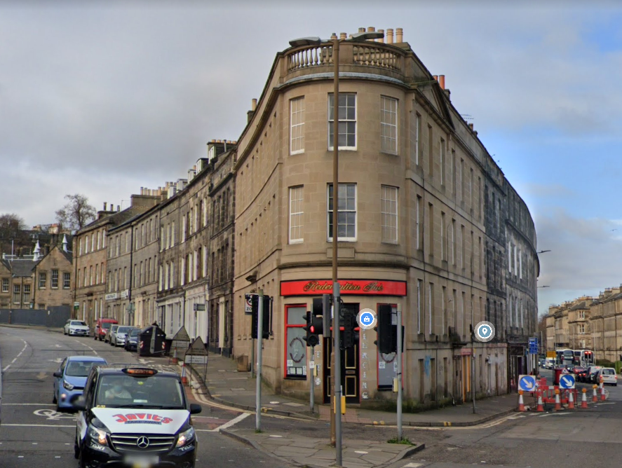
A staircase was already provided for convenience of getting between the Regent Road and West Norton Place. It's still there, and was only recently shut off as a through route as being in disrepair.


Norton Place developed into a little block of Regency tenements in its own right at the eastern end, but remained undeveloped at the west until much later.
In 1872 or so, the Heriot Trust built a school in the sliver of land between Norton Place and the new alignment of Easter Road, which would become Regent Road School when the School Board took it over, later the Abbeymount Techbase (now @ootbabbeymount ).


And between then and 1893, our starting point of that staircase was built. It was built because somebody had filled in the bridge 72 years before that had spanned the direct desireline on foot between Easter Road, Abbeyhill and the Canongate.

What is now the "derelict" gap site is formed from what was a petrol station on the Regent Road side (for a long time this section has been called Montrose Terrace) and demolished tenements at 4-11 West Norton Place

So next time you stand at the top of Easter Road and look straight ahead and wonder why the road goes the other way, the answer is that you're looking at a Georgian on-ramp that was put in in a hurry to solve some Georgian traffic-flow problems.

I think that's a good place to call it a night. Here is this full thread as one single, unrolled page 🪡threadreaderapp.com/thread/1493000…
Of course that's not really the end of the story for the alignment of London Road and Regent Road here, as they had to be moved again about 40 years later to carry them over the railway, further messing up Stevenson's alignments
https://twitter.com/cocteautriplets/status/1244920903793868800?s=20&t=xUGfaPljw2FR_svwEE2qOg
Appendix. I have found what I think is the best image that shows the old road past Abbeyhill from the Canongate to Easter Road, before Stevenson's Regent Rd and bridge was built over it and re-landscaped the area forever. It is in Thomas Sandby's ~1750 panorama from Arthur's Seat
Sorry, it's Thomas and not his brother Paul. The panorama is a is remarkable in its own right for its scale, accuracy and detail - as I always say, Paul and Thomas Sandby were both artists AND surveyors and real masters at blending the art and science of both together.

Zooming in on the far right of the image, over the rooftop of Holyrood Palace and the Abbey Church, we see the village of Abbeyhill (pink), the Quarryholes (blue), the old Easter Road (yellow) and Leith (green) in the distance beyond the farmland.


Notice also here the Abbey Church has a "Dutch" steeple - in common with the Tron, North Leith and South Leith kirks.

• • •
Missing some Tweet in this thread? You can try to
force a refresh


