Do you know there existed a piece of India within Bangladesh within India within Bangladesh?🤯🤯
This is the story of how some historical laziness led to a weirder geography for our country.
An interesting midweek story for you 🧵
1/n
This is the story of how some historical laziness led to a weirder geography for our country.
An interesting midweek story for you 🧵
1/n

An 'Enclave' is a geographical territory of a country/state that is entirely surrounded by the territory of another country.
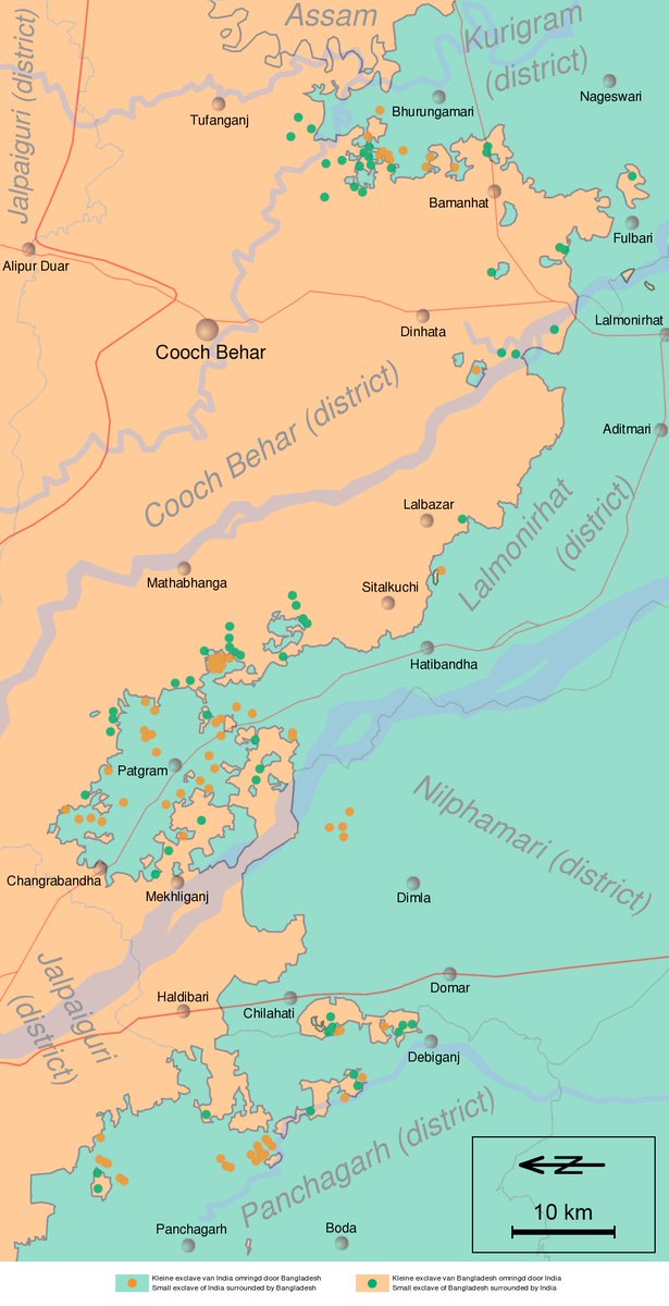
During the partition of 1947, Cooch Behar district in West Bengal and Rangpur in East Pakistan ended up with hundreds of enclaves on either side
2/n
During the partition of 1947, Cooch Behar district in West Bengal and Rangpur in East Pakistan ended up with hundreds of enclaves on either side
2/n

The folk history of how these small enclaves came to be is that the Rajas of Cooch Behar & Rangpur traded them hastily as stakes in gambling leading to this weirdness😃
The more reliable story is that the war of 1713 between Behar & Mughals ended without deciding on borders
The more reliable story is that the war of 1713 between Behar & Mughals ended without deciding on borders

An enclave is present in many countries. But this mess went to another level.
India had 102 Enclaves in Bangladesh which in turn had 21 Counter Enclaves! Territory of Bangladesh within the Indian enclave 🤯🥺
Bang had 71 Enclaves in India of which 7 were counter enclaves again!
India had 102 Enclaves in Bangladesh which in turn had 21 Counter Enclaves! Territory of Bangladesh within the Indian enclave 🤯🥺
Bang had 71 Enclaves in India of which 7 were counter enclaves again!

But the best part comes now.
Dahala Khagrabari was the world's only Counter - Counter Enclave!
India inside Bangladesh inside India inside Bangladesh!
Imagine people here having to cross 5 national borders to go to school few kilometres away! 😇😃
Dahala Khagrabari was the world's only Counter - Counter Enclave!
India inside Bangladesh inside India inside Bangladesh!
Imagine people here having to cross 5 national borders to go to school few kilometres away! 😇😃

Dahala Khagrabari is only 7000 square metres in size - a size of a jute field there but it held an unique geographical record!
We even had a small road protected with fences for citizens to go to these enclaves separately. One such is the Tin Bigha Corridor just 85 metres wide!
We even had a small road protected with fences for citizens to go to these enclaves separately. One such is the Tin Bigha Corridor just 85 metres wide!

Ideally these should have been exchanged between India & Pakistan during the partition in 1947. But by the time the courts could decide what to do, India-Pak relations had worsened & we had to wait until 1971 to start talks with Bangladesh again.
But it took another 45 years..
But it took another 45 years..

In 2015, this situation was fixed when the 2 govts decided to exchange the enclaves on either side to put an end to this anomaly with citizens given option to choose sides
Laziness from 1713 was finally addressed in 2015!
RT this thread if you liked it & follow for more 🙏
Laziness from 1713 was finally addressed in 2015!
RT this thread if you liked it & follow for more 🙏

• • •
Missing some Tweet in this thread? You can try to
force a refresh


