It's #BeerDay, so raise a glass to Göbekli Tepe in 🇹🇷.

This ~12,000-year-old site is an early monument made by hunter-gatherers. It features some of the oldest possible evidence of beer drinking, made from wild cereals.🍻

🔗 from 2012 (🆓) buff.ly/3gmerNk Excavations revealing a series of three large circular stone
Troughs at the site contain traces of the grains that could be used to make beer.

Alternatively, the grains could have been used to make porridge (the researchers can't tell if it was fermented or not). But beer seems like a great motivator to build such a monumental site.
Throughout history, people have gone to extreme lengths for beer.

Like in Iceland, where the cold meant growing barley was hard. But Vikings did it so they could make beer.

🔗 from 2013 (£) buff.ly/3icyf6d
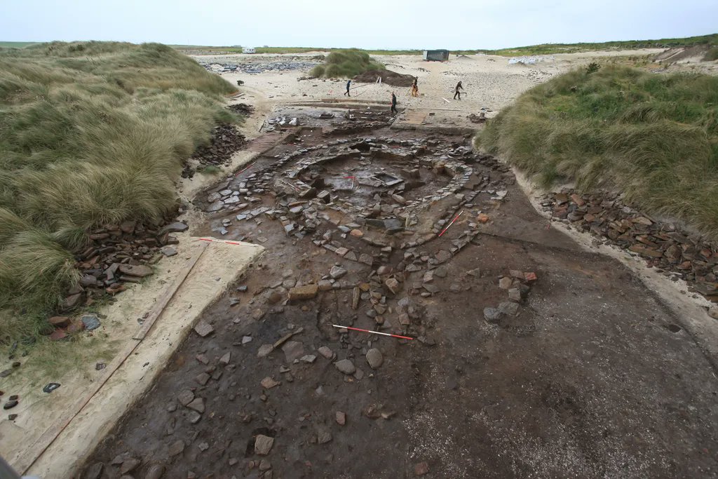
📷: A Viking hall where the beer was likely consumed
So if you plan to celebrate #BeerDay, be glad you didn't have to build a giant monument or grow barley near the Arctic first! 🍻

• • •

Missing some Tweet in this thread? You can try to force a refresh
 

Keep Current with 🅰ntiquity Journal

🅰ntiquity Journal Profile picture

Stay in touch and get notified when new unrolls are available from this author!

Read all threads

This Thread may be Removed Anytime!

PDF

Twitter may remove this content at anytime! Save it as PDF for later use!

Try unrolling a thread yourself!

how to unroll video
  1. Follow @ThreadReaderApp to mention us!

  2. From a Twitter thread mention us with a keyword "unroll"
@threadreaderapp unroll

Practice here first or read more on our help page!

More from @AntiquityJ

Jun 16
The archaeology of Doggerland - the submerged prehistoric landscape in the North Sea - could be destroyed by ambitious plans for offshore wind power, making it important to study it first.
buff.ly/3Hothi6 Image
It was thought a devastating tsunami submerged Doggerland ~10,000 BC. However, research shows some of the lost landscape survived this catastrophe.

📷: Left) Doggerland ~12,000 BC; right) when the tsunami hit ImageImage
The tsunami was triggered by a giant submarine landslide in the North Sea ~8,150-years-ago.

📷: The location of the landslide, by Lamiot / CC BY-SA 3.0 Image
Read 7 tweets
Jun 16
A ruin inside a ruin!

The ruin of St Mary's Church in Reculver, Kent, is itself inside the ruin of a Roman fort called Regulbium (the surrounding area of mown grass) #RomanFortThursday

📷 by Geoff soper / CC BY-SA 4.0 Aerial photo of a river ban...
Here's an image from 1781, showing the intact church and part of the Roman wall (bordering its grounds in the bottom left). Image
Here's a picture of the wall itself, taken in the 1930s by the founder of Antiquity OGS Crawford. Image
Read 5 tweets
Jun 15
Archaeologists have discovered a system of hidden tunnels beneath the pre-Inca Chavín de Huántar temple complex in Peru.
buff.ly/3mGZB6v A stone brick temple, mossy...
At the 1st millennium BC site, exclusionary drug use appears to have taken place. A small number of priests appear to have consumed the hallucinogen vilca in enclosed galleries.

📷: Vilca seed Image
Later in South American history, drug use became less exclusive and more inclusive. The Wari Empire served beer laced with vilca at feasts. The Inca served huge quantities of maize beer.

📷: Jar for the Wari beverage Image
Read 4 tweets
Jun 14
The Temple of Hatshepsut, an Ancient Egyptian complex with three large terraces.

It was constructed for Pharoh Hatshepsut, one of the few confirmed female Pharaohs, who ruled Egypt ~3,500-years-ago #TombTuesday In the distance, a large an...
The impressive Temple served as a venue for religious festivals and a place where Hatshepsut's mortuary cult could continue to leave offerings and give rites for her.

📷: The Temple from above, showing its multi-layered structure. By Wouter Hagens / CC BY-SA 3.0 Image
The mortuary cult used a side room, known as the Chapel of Hatshepsut, which was decorated with massive reliefs depicting offerings being given to the Pharoh.

📷: Archaeologist documenting the relief. Image
Read 5 tweets
Mar 30
A Roman villa with a large mosaic depicting the Iliad was discovered in Rutland (🇬🇧) last year. A geophysical survey has revealed the complex covered 50,000 m2 with a garden, bathhouse, chapel and mausoleum.
buff.ly/3LswZIx
Ground-penetrating radar helps archaeologists study several sites without having to dig anything up.

Here, it's used to map the Roman city of Falerii Novi in 🇮🇹, identifying shops, temples, and more.

🔗 from 2020 (🆓) doi.org/10.15184/aqy.2…
Ground-penetrating radar also revealed a previously unknown Viking ship burial at Gjellestad in 🇳🇴 - the first such burial to be excavated in nearly 100 years!

🔗 from 2020 (🆓) buff.ly/35iDY4C
Read 4 tweets
Mar 30
🆕: Research at a 4000-year-old village in Orkney exploring the impact of a female-dominated wave of migration has revealed it led to a peaceful and productive period.

An #AntiquityThread (paper: buff.ly/3qLnUlY) 1/n 🧵
Note: This research analysed a cemetery at the site, so this thread will feature some human remains. 2/
The Links of Notland site on Westray is one of the best-preserved and most extensive prehistoric settlements in Scotland. 3/

📷: Location map of the site
Read 20 tweets

Did Thread Reader help you today?

Support us! We are indie developers!


This site is made by just two indie developers on a laptop doing marketing, support and development! Read more about the story.

Become a Premium Member ($3/month or $30/year) and get exclusive features!

Become Premium

Don't want to be a Premium member but still want to support us?

Make a small donation by buying us coffee ($5) or help with server cost ($10)

Donate via Paypal

Or Donate anonymously using crypto!

Ethereum

0xfe58350B80634f60Fa6Dc149a72b4DFbc17D341E copy

Bitcoin

3ATGMxNzCUFzxpMCHL5sWSt4DVtS8UqXpi copy

Thank you for your support!

Follow Us on Twitter!

:(