Nature Desai Profile picture
Jun 19, 2022 6 tweets 3 min read Read on X
#SundaySpecial

The villages razed in Rakhine State of Burma are now home to wild vegetation.

It now appears as if they never existed !

20°53'56.88"N, 92°23'28.20"E

1/6
Selective destruction in large towns are now being replaced by some sort of pre - fab housing facilities.

20°49'34.12"N, 92°21'54.46"E

2/6
#Erased

Not a trace of lively settlement visible after 5 years.
🤷‍♂️

20°56'9.11"N, 92°21'37.21"E

3/6
#SkewedDevelpment

Large Settlement completely razed is now replaced by government Buildings.

20°49'31.54"N, 92°23'28.79"E

4/6
#RefugeeCrisis

Refugees from Myanmar relocated in large Camps functioning with UN Aid in Bangladesh near her border with Brahmadesh.

Bangladesh FM informed Indian EAM regarding the situation in these refugee camps

5/6 Image
#geopolitics

India, To provide alternate openings to her North-East via Sea and in case of some troubles near the 'Chicken's Neck' ; developed some Trans-National projects connecting Mizoram and Tripura via Ports of Bangladesh and Myanmar in the Bay of Bengal.

6/6 Image

• • •

Missing some Tweet in this thread? You can try to force a refresh
 

Keep Current with Nature Desai

Nature Desai Profile picture

Stay in touch and get notified when new unrolls are available from this author!

Read all threads

This Thread may be Removed Anytime!

PDF

Twitter may remove this content at anytime! Save it as PDF for later use!

Try unrolling a thread yourself!

how to unroll video
  1. Follow @ThreadReaderApp to mention us!

  2. From a Twitter thread mention us with a keyword "unroll"
@threadreaderapp unroll

Practice here first or read more on our help page!

More from @NatureDesai

Apr 21
#Exclusive

Thread:

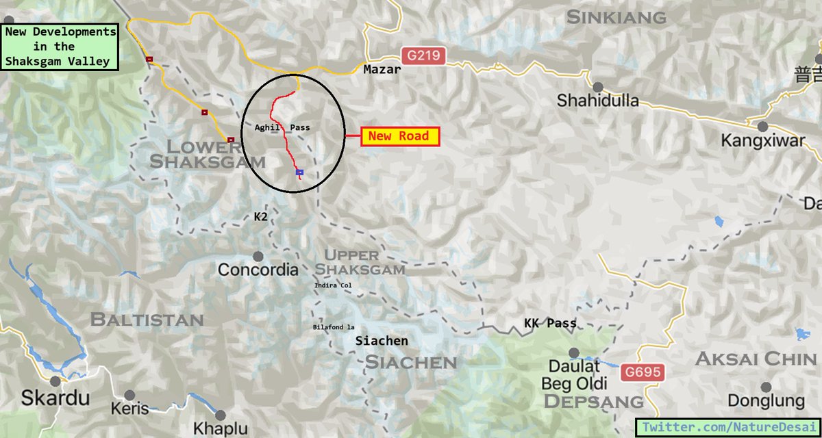
In a significant development, 🇨🇳 road has breached the border at Aghil Pass (4805 m) and entered the lower Shaksgam valley of Kashmir, 🇮🇳 with the road-head now less than 30 miles from 🇮🇳 Siachen

This permanently answers the question of Shaksgam for 🇮🇳

1/4 Map showing recent developments in Shaksgam valley.
Aghil Pass served as the northern frontier of Kashmir and Sinkiang in bygone times.

Here is the approach to Aghil Pass and recent imagery showing the Chinese road at the Aghil Pass.

The change in the status quo in Tans-Karakoram is almost impossible to reverse.

2/4
Camels enroute Aghil pass from sinkiang.
lake near aghil pass and now a road visible near it
Time-lapse showing Chinese road approaching Aghil Pass. It all started last summer and the basic trail was completed in early autumn.

They have resumed further construction this month with construction approaching areas immediately north of India held Siachen Glacier.

3/4
Read 4 tweets
Oct 11, 2023
Thread:

As the world drifts away in a geopolitical arm-twisting by major players, tiny kingdom in the eastern Himalayas faces the wrath of her northern neighbour.

To grab concessions near 🇮🇳 frontier, 🇨🇳 grabs 🇧🇹 territories in the north.

For recent developments ⬇️ Map showing roads, residential areas and buildings built by China in Bhutanese territory of northeastern region namely jakarlung and pasamlung valleys
In 2023, China started building houses along the road they built in the Bhutan's Jakarlung valley.

In a bid to populate newly grabbed territories to have a valid claim, such new developments might have led to Bhutanese concessions during border demarcation negotiations. Chinese developments in Jakarlung Valley.
A node in the upper Jakarlung valley saw new developments recently, adding multiple buildings there, which also serves as a staging point for a road leading to the Pasamlung valley.

Bhutanese PM is willing to negotiate a quick demarcation before he leaves office a month later. Chinese developments in upper Jakarlung valley
Read 6 tweets
Jun 5, 2023
The frontier where southern plains (meiteis) meet hills (kukis) also witness to the initial ethnic clashes in the first week of May.

gif showing destruction at Kangvai bazar, Manipur
(March2022 - 8 May2023)

@Kautilya33, @SushantSin, @Kyangs_Thang, @rwac48

1/5
gif showing complete destruction of houses at torbung, Manipur
(March2022 - 8 May2023)

2/5
gif showing destruction just north of 54 Sector BSF post - Torbung Bangla, Manipur.

(March2022 - 8 May2023)

3/5
Read 5 tweets
Dec 23, 2022
#Exclusive

New xiaokang (resettlement village) built in 2022 just 2 miles north of LAC near Bum La.

It is the only village built this year. Total 6 such villages were built in the area opposite Bum La (also known as nagdoh bowl) in last few years.

Further analysis below!

/1 Map showing developments in Nagdoh bowl opposite Bum La
Timelapse showing the transformation of the Tibetan settlements to modern villages.

Dual use infrastructure?

@bsdhanoa and @rakesharma15 certainly say so...

/2
Yes, they must be considered as dual use infrastructure.

Villages with trenches and prepared defences is not equal to moderately prosperous societies.

Image shows xiaokang 1 shown in the first map with permanent PLA defences nearby.

/3 Xiaokang  opposite Bum La
Read 7 tweets
Dec 12, 2022
Thread:

Basic Explainer of the recent clash in the Eastern Himalayas.

Location: Yangtse Sector, which is located some 25 km NE of Tawang as the crow flies. Same area was a site of another clash in 2021 when PLA built a pucca road towards saddle.

No sneak peek for PLA.
(1/4) Map showing relative locati...
PLA recently upgraded a road and built some portion entirely new. It helps improve logistics to their main artery connecting Tsona Dzong and Bum La.

Area is witness to multiple clashes in last 2 decades due to differing perceptions of the frontier.

(2/4) Map showing recently built ...
Newly built Xiaokang serve as their firm base. News report suggest contention of 17000+ feet heights in the area if controlled by the adversary can give venerable observation point to monitor our movements.

(3/4) The strategic consequences
Read 4 tweets
Sep 19, 2022
#Exclusive

Return of the Empire and The Age of the Expansionism.

The frontier policy of the great civilization brings to life the ancient kingdom of Guge.

Multiple Xiaokang (well-of) villages popped up during last few months in the remotest frontier of Tibet.

@SushantSin Map showing new Xiaokang vi...
Tsaparang-the capital of the ancient kingdom Guge in the Garuda Valley near Toling monastery, from where the second dissemination of Buddhism in Tibet emanated has witnessed tremendous development in last few years from establishment of a new garrison to now new xiaokang villages Credit: © 2022 Planet Labs
The Satluj River Basin is one of the remotest frontiers of the great civilization with harsh climate and deep canyons as part of its physical geography. The re-population of this region via dual use infrastructure projects suggest a drive to strengthen the western border. Credit: © 2022 Planet Labs
Read 6 tweets

Did Thread Reader help you today?

Support us! We are indie developers!


This site is made by just two indie developers on a laptop doing marketing, support and development! Read more about the story.

Become a Premium Member ($3/month or $30/year) and get exclusive features!

Become Premium

Don't want to be a Premium member but still want to support us?

Make a small donation by buying us coffee ($5) or help with server cost ($10)

Donate via Paypal

Or Donate anonymously using crypto!

Ethereum

0xfe58350B80634f60Fa6Dc149a72b4DFbc17D341E copy

Bitcoin

3ATGMxNzCUFzxpMCHL5sWSt4DVtS8UqXpi copy

Thank you for your support!

Follow Us!

:(