
Today a 🧵on mining maps, how to look at them, and what they tell us about how people perceived the underground world! With bits of map history, paper history, and obviously lots of #UndergroundMathematics. For the untrained eye, these maps are difficult to understand... #HistSTM 


These maps are in fact a recent development, mostly in the 17th century. An old miner’s proverb said that “no one can see through stone”, and in fact it used to be a huge problem: how to see limits of concessions, to locate water wheels and ore vein?

In the 15th c. there was virtually no room for maps. Extraction was monitored directly, by visitations from mining masters and jurors, as their ‘Augenschein’ (visual inspection) was decisive. Things began to change bc rulers wanted to monitor their underground riches at distance
How to replace the ‘Augenschein’, the visual on-site inspection? Many solution were attempted, with clay and wood models, written reports and auditions, but it’s really hard to express the direction of a vein or the hardness of stones with words...
In the 17th century then, mine surveyors began to systematically collect measurements, and were able to produce ground maps. That was already useful, but the depth is lacking … what follows are lots of comments, glued slips of papers with metric indications and so on.

In fact, the ‘mining maps’ depicted in books mostly show the figurative part of the work. At the time, surveyors usually provided not only the nice colored part but also commentaries and list of angles.
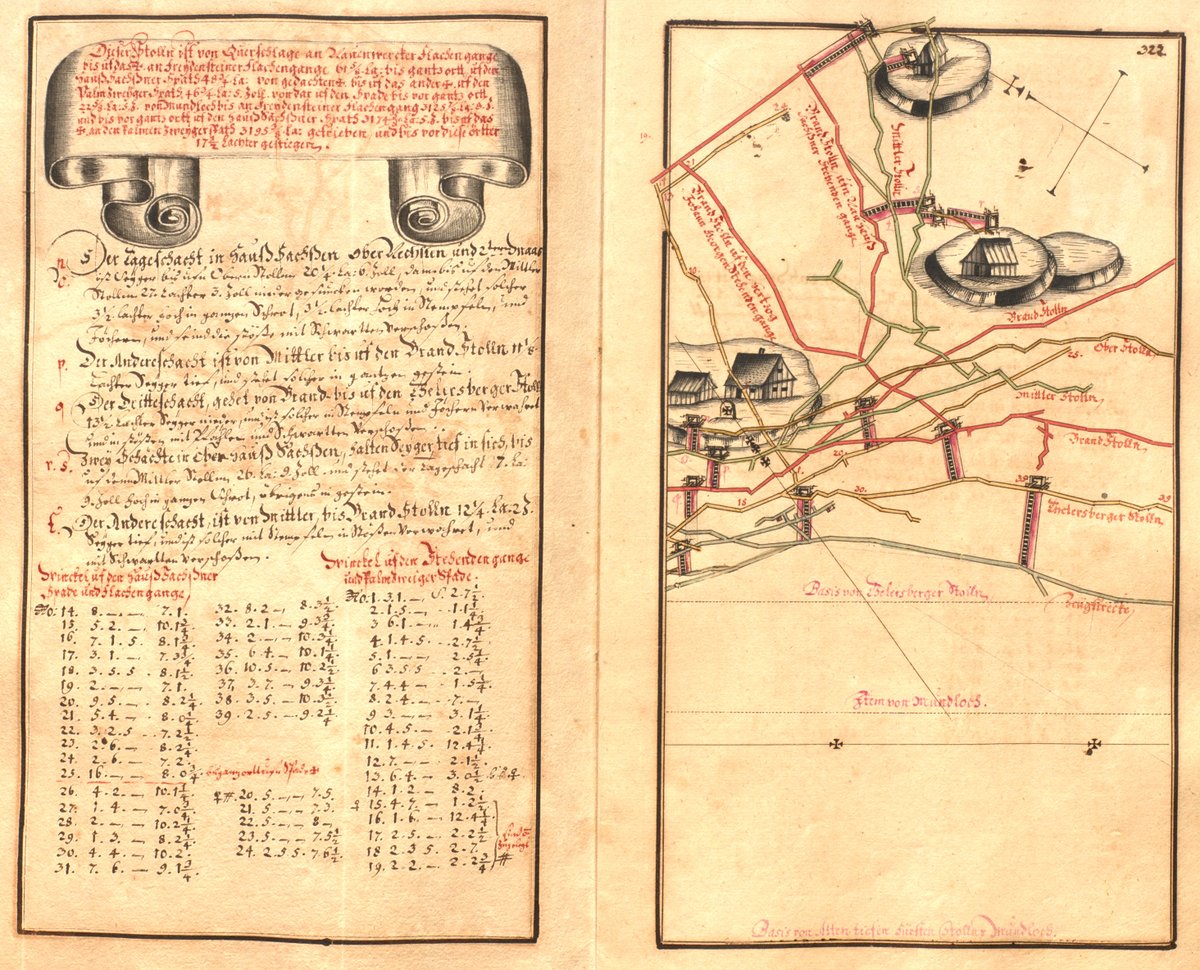

Using this data, a skilled underground surveyor was able to produce a geometrical depiction of the underground, using a pair of compasses: the littles holes can still be seen in the maps! Colors and illustrations are added later, the real stuff is the mathematics!


Recording hundreds, thousands of angles was a hard, ‘blood-souring work’, in the words of surveyor Johann Berger. And indeed, Berger died of exhaustion shortly after completing his masterpiece, the ‘Freiberga Subterranea’

Mining maps were not simple depictions of the underground but, as is the case with all technologies, they embodied political choices … This new mine geometry was promoted by Captain-General of the mines, Abraham von Schönberg, who lent his credibility to surveyors!


Note the similitude between the frontispieces of Voigtel’s geometry textbook (a copper plate) and Berger’s cartographic masterpiece (a handwritten one): both were sponsored by Schönberg, and guess what his coat of arms was? ... End of the 🧶


🔗to the table of contents of #UndergroundMathematics, preorders at @CambridgeUP
and all kind of info ➡️cambridge.org/core_title/gb/… !
and all kind of info ➡️cambridge.org/core_title/gb/… !

• • •
Missing some Tweet in this thread? You can try to
force a refresh


