Anthony Masiello Profile picture
Apr 15 5 tweets 2 min read Twitter logo Read on Twitter
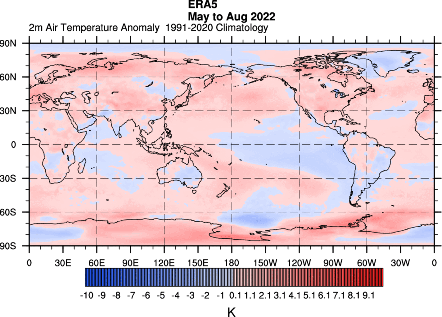
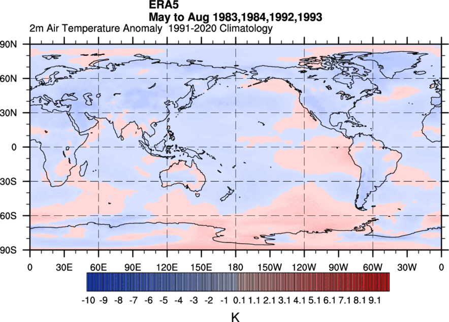
Whether it's tropical cyclones, SE US flooding, or widespread record warmth, there is a nonlinear component to the general circulation that drives the anomalous weather. An amplified ER worked in tandem with an Asian synoptic RWT to amplify the flow (see subsequent tweets).
Watch the darker blue colors just off the Equator move westward in this moving 5-day mean (negative OLR=convection), as the gradient in velocity potential tightens up near the Mei-yu Front. Impressive coherence for the RW here and its interaction with the Extratropics.
The seeding from Asia and the extra diabatic assist from the tropical convection, created a wave train that amplified the flow over North America, setting the stage for the various anomalous weather events.
These synoptic wave trains that emanate from Asia and amplify across North America will then propagate into the Atlantic-Europe-Africa sectors. They help to propagate the MJO signals through the western hemisphere by the upper level winds.
In my dense Pacific Jet threads, I linked a paper about Asian wave train seeding and diabatic forcing from the western Pacific. It relates to this situation too.

• • •

Missing some Tweet in this thread? You can try to force a refresh
 

Keep Current with Anthony Masiello

Anthony Masiello Profile picture

Stay in touch and get notified when new unrolls are available from this author!

Read all threads

This Thread may be Removed Anytime!

PDF

Twitter may remove this content at anytime! Save it as PDF for later use!

Try unrolling a thread yourself!

how to unroll video
  1. Follow @ThreadReaderApp to mention us!

  2. From a Twitter thread mention us with a keyword "unroll"
@threadreaderapp unroll

Practice here first or read more on our help page!

More from @antmasiello

Jan 16
🧵The Pacific Jet & collapse-of-La Niña pattern in late December 2022 was interesting. I want to talk about it some more (BTW, it has been a while! I hope you're all doing well!). I'm going to focus on general circulation, and then dive into synoptic RWTs another time. (1/n)
This thread alone won't answer *the-why* solely. But, the rapid onset to the -TNH pattern can be a good place to start analysis (cpc.ncep.noaa.gov/data/teledoc/t…). Eric touched on this while the changes were underway. But what are the nature of these years? (2/n)
Typical La Niña circulation in December consists of a Rossby Wave Train from the Tropical Pacific to North America (upper low east of Dateline in Subtropics, Aleutian high). Here is a December 200mb mean of both January -TNH & +TNH La Niñas rolled back. (3/n)
Read 14 tweets
Oct 14, 2022
1/ Thread: Volcanoes, South American Monsoon System (SAMS), and the ITCZ over the Atlantic (influence on TCs). Research focuses on typical SO2/aerosol temp relationships of famous eruptions and then proceeds from there, but 2022 is opposite of those. cp.copernicus.org/articles/12/96…
2/ As previously discussed, the water vapor cooling in the southern hemisphere's stratosphere, and tropospheric warming, is the opposite configuration of years that followed Pinatubo/El Chichón. This influences the SAMS.
3/ No year in modern record can be analogous to 2022 in this regard. But is there a way to use the modern record to develop relationships with the SAMS/ITCZ during May-Aug? I used the ERA5 dataset and chose cold/warm years to see if basic relationships exist.
Read 15 tweets
Sep 29, 2022
The gradual move NE on the ECMWF for LF location tomorrow:
Mostly due to starting point/speed off FL. *Image not updated for 12z run yet: Image
whoops (ECMWF)... 🙄 ImageImage
Read 4 tweets
Jun 23, 2020
[#severe climo thread] Is there something about late May? I totaled all severe reports for NY, NJ, PA, DE, MD and DC for the months of April to July (data source SPC, 1955-2018). For severe wind reports, they increase overall from April to July (but notice late May rise). (1/8)
In terms of severe hail, notice the peak in reports happens in late May to early June with the 10-day average peak right around the infamous date of 5-31. (2/8)
Tornadoes overall gradually increase from the start to the end of the period. However, the notorious period of the end of the May into early June again sticks out with peak in daily counts and rolling averages. (3/8)
Read 8 tweets
Jan 1, 2020
Here's a 10-day mean SST in Reanalysis that spans the month of December in 3 blocks. It is scaled to be ~ 80°F-90°F. Of course you've heard about Australia's warmth. The +SSTa have intensified near WA/NT/QLD. Some SST approaching 90°F there.
EPS TC forecast in the next 10 days. This is why the RMMs are forecast to spike into phase 4-6.
Information from BOM on their tropical season: bom.gov.au/cyclone/climat…
Read 8 tweets
Feb 27, 2019
Profiles tonight are marginal all around but worth mentioning. Not a lot of sunshine today and it has been cold. Profiles are somewhat supportive of spotty freezing drizzle. Not certain if sufficiently moist. Doesn't look like it goes into AM commute either with wind shift.
Here's an example NAM sounding for tonight. Not all modeling looks like this.
Here's what the frontal area looks like now:
Read 10 tweets

Did Thread Reader help you today?

Support us! We are indie developers!


This site is made by just two indie developers on a laptop doing marketing, support and development! Read more about the story.

Become a Premium Member ($3/month or $30/year) and get exclusive features!

Become Premium

Don't want to be a Premium member but still want to support us?

Make a small donation by buying us coffee ($5) or help with server cost ($10)

Donate via Paypal

Or Donate anonymously using crypto!

Ethereum

0xfe58350B80634f60Fa6Dc149a72b4DFbc17D341E copy

Bitcoin

3ATGMxNzCUFzxpMCHL5sWSt4DVtS8UqXpi copy

Thank you for your support!

Follow Us on Twitter!

:(