Forensic Architecture Profile picture
Oct 20, 2023 10 tweets 4 min read Read on X
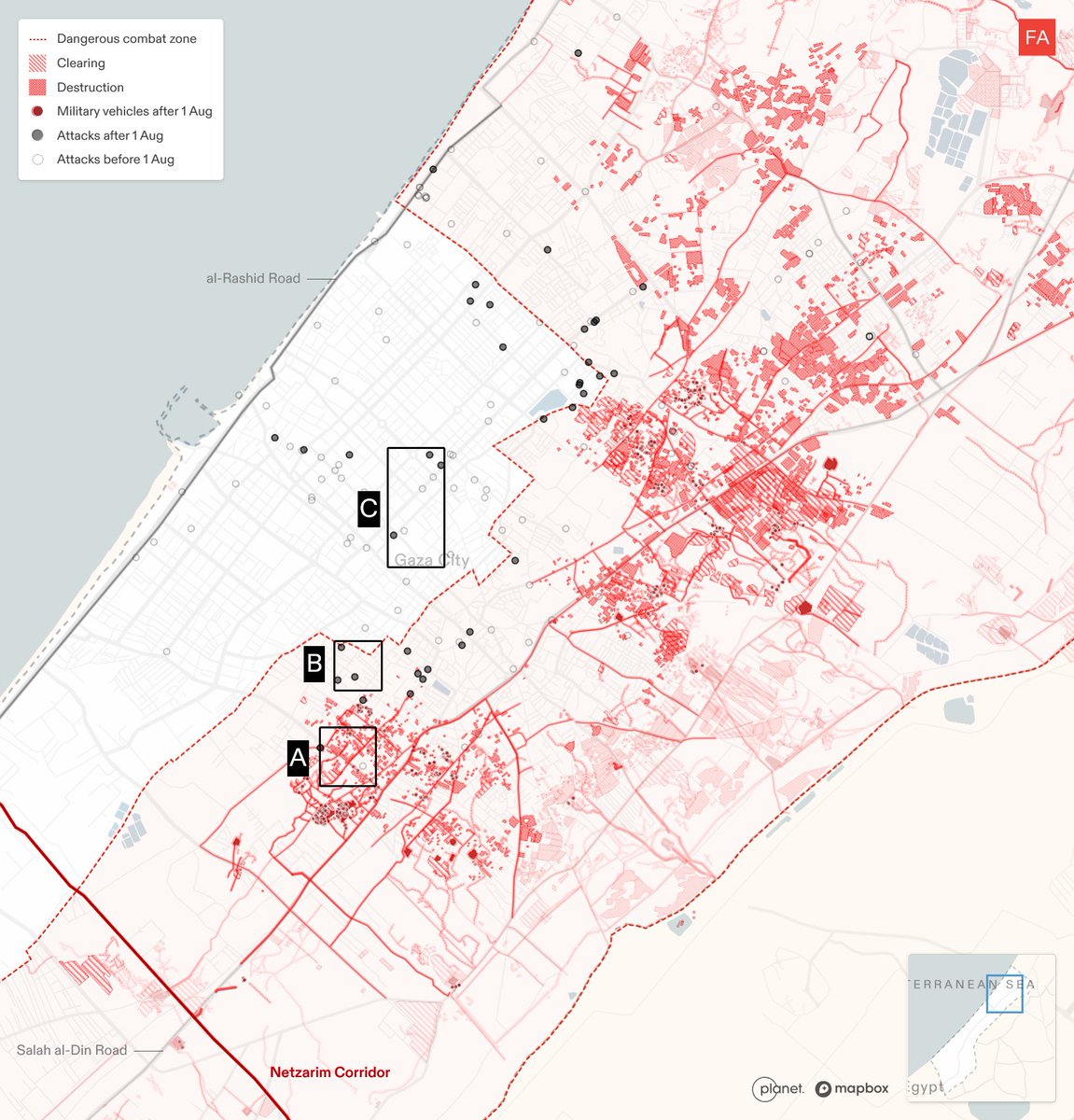
Preliminary analysis by FA, @alhaq_org & @earshot_ngo into the #AlAhli hospital blast in Gaza casts significant doubt on IOF claims that the source of the deadly explosion was a Palestinian-fired rocket travelling west to east. Image
3D analysis shows patterns of radial fragmentation on the southwest side of the impact crater, as well as a shallow channel leading into the crater from the northeast. Such patterns indicate a likely projectile trajectory with northeast origins.
In reviewing our analysis, investigator & explosive weapons expert @CobbSmith agrees the fragmentation patterns may indicate the projectile came from the northeast—the direction of the Israeli-controlled side of the Gaza perimeter—and not from the west, as claimed by the IOF. Image
Our/@CobbSmith’s analysis of the crater size suggests a munition larger than eg a Spike or Hellfire missile commonly used by IOF drones. It is more consistent w/ the impact marks from an artillery shell—but w/o additional material evidence, we cannot make a definitive assessment. Image
This image taken by John Moore in Kharkiv Oblast, Ukraine in 2022 shows the directionality of fragmentation of an artillery shell - - compared to the crater at the #AlAhli sitegettyimages.dk/detail/news-ph…
Drawing upon available footage, our partner @earshot_ngo performed independent audio analysis of the missile attack, the findings from which lend further credibility to our preliminary assessment of directionality:
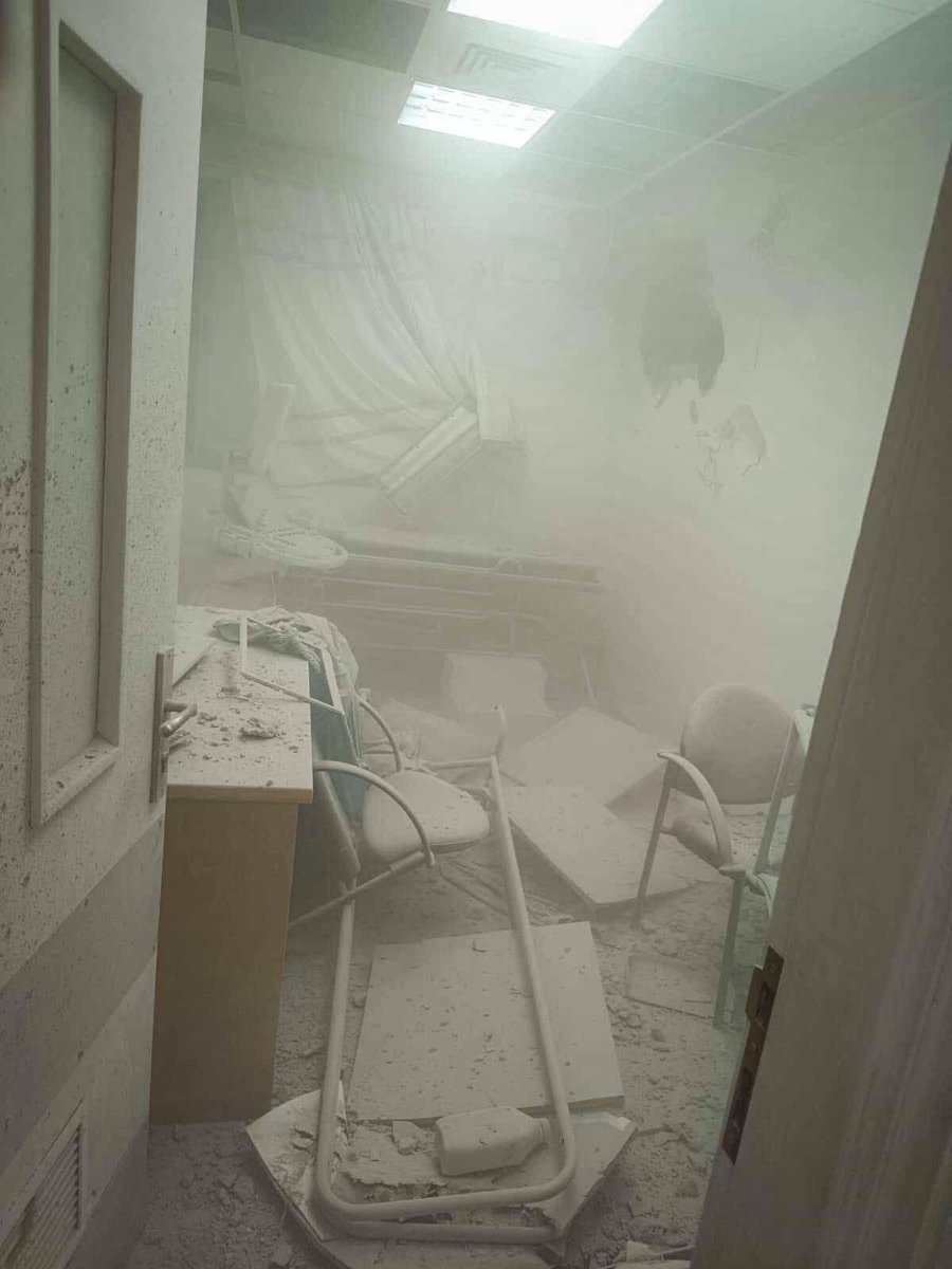
Israel has falsely claimed that ‘the IDF does not hit hospitals’. @alhaq_org has footage of an IOF strike on the Al-Ahli Hospital cancer ward on 14 Oct (see image stills), and WHO has reported 59 attacks on healthcare in Gaza and 137 across the Occupied Territory since 7 Oct.

Image
Image
Image
The IOF has a long history of providing false and misleading information after it has targeted and killed civilians. See: our investigations into the killing of Shireen Abu Akleh and the bombing of the Al-Katibah building forensic-architecture.org/investigation/…
forensic-architecture.org/investigation/…
@earshot_ngo analysed the recording released by IOF officials of an alleged exchange between members of Hamas implicating the Islamic Jihad in the attack. They found that the recording was manipulated and therefore not a credible source of evidence:
A conclusive investigation into this attack requires full access to the site and munition fragments, as well as witness interviews. We continue our work on this case, and reaffirm our solidarity with Palestinian people under attack, including our friends & colleagues.

• • •

Missing some Tweet in this thread? You can try to force a refresh
 

Keep Current with Forensic Architecture

Forensic Architecture Profile picture

Stay in touch and get notified when new unrolls are available from this author!

Read all threads

This Thread may be Removed Anytime!

PDF

Twitter may remove this content at anytime! Save it as PDF for later use!

Try unrolling a thread yourself!

how to unroll video
  1. Follow @ThreadReaderApp to mention us!

  2. From a Twitter thread mention us with a keyword "unroll"
@threadreaderapp unroll

Practice here first or read more on our help page!

More from @ForensicArchi

Jun 14
NEW: Salman Abu Sitta is a Nakba survivor and historian of Palestine. Together, we digitally reconstructed his birthplace, the village of al-Ma’in, exploring its history and documenting how, in 1948, the village was destroyed and its people forcibly expelled: forensic-architecture.org/investigation/…
On 14 May 1948, al-Ma’in was occupied and demolished by Zionist forces. Image
We reconstructed the village to uncover its layered history — from its vibrant agricultural life, with a 95-metre deep well and a bayarah, to the 60,000 dunams (15,000 acres) of land cultivated by the Abu Sitta family, mostly wheat and barley.
Read 6 tweets
Jun 6
FA has documented a pattern of Israeli attacks on areas into which they have previously instructed civilians in Gaza to evacuate. Our research confirms that the Israeli military carried out multiple attacks in areas towards which civilians had been directed, either on the same day as the evacuation order, or on the day after. See more: frames.forensic-architecture.org/gaza/updates/a…
1) On the morning of 23 Mar 2025, the Israeli military issued an evacuation order for Tel al-Sultan neighbourhood of Rafah, directing civilians to move northeast. That evening, there was an airstrike northeast of Tel al-Sultan, in Khan Younis, that hit the Nasser Medical Complex, the largest hospital in the area.Image
2) On the morning of 7 Apr 2025, the Israeli military issued an evacuation order to Deir al-Balah, directing civilians to move southwest. Later that day, there was an attack on a residential building southwest of Deir al-Balah. The following day, there were two attacks in areas southwest of Deir al-Balah.
Read 6 tweets
Jun 6
Israel has designated the majority of the Gaza Strip for evacuation. 34 evacuation orders have been issued to civilians in Gaza since the dissolution of the ceasefire on 18 March 2025. Many of these orders define differing boundaries for the militarised buffer zone in the east of Gaza, gradually expanding the area designated for evacuation. See more: frames.forensic-architecture.org/gaza/updates/i…
We have documented 4 instances where the declared boundaries of the buffer zone have subsumed areas previously subject to evacuation orders. As of 3 June 2025, the buffer zone has expanded to encompass the municipality of Rafah, as well as areas to the east of Khan Younis and in the north of Gaza.
For example, an evacuation order was issued to the municipality of Rafah on 31 March and 1 April. In an evacuation order issued on 6 April, the declared buffer zone expanded to encompass the areas previously designated for evacuation.
Read 4 tweets
May 16
Israel is constructing a second militarised ‘corridor’ in Gaza, to expand their control of the Strip. Plans for the Morag Corridor were announced on 2 April; since that time, we’ve identified widespread destruction throughout the remains of Rafah city, and several new Israeli military outposts. Follow this developing situation in our new mapping portal: frames.forensic-architecture.org/gaza/updates/m…
A comparison of satellite imagery from 3 April and 11 May reveals how entire areas of central Rafah have been destroyed by the Israeli military.
During the same timeframe, the Israeli military destroyed dozens of buildings and greenhouses, as well as agricultural land, to the north of Rafah, to make way for the construction of the Morag Corridor.
Read 7 tweets
Mar 10
At the summit last week on 4 March, a new plan for Gaza’s reconstruction was presented by Arab leaders as an alternative to Trump’s plan to expel Palestinians from Gaza. Our analysis indicates that this initiative—which has gained support from the European Council—includes an architectural master plan that carries forward key elements of Israel’s designed destruction of Gaza (as addressed in our Cartography of Genocide report bit.ly/cartography-of…), with its proposal for a ‘buffer zone’, security corridors, and raid routes.
The Egyptian master plan consists of three parts.

1. Buffer Zone: Since October 2023, Israel has destroyed all structures within 1,000-1,500 metres of the Gaza perimeter fence and targeted Palestinians who entered this zone. The Egyptian plan integrates the buffer zone into its design and effectively endorses the erasure of multiple historically and politically significant Palestinian neighbourhoods, including Jabalia and Shuja’iyya, by rezoning them for agricultural, investment, and industrial purposes.Image
2. Security corridors: Since October 2023, Israel constructed a six-kilometre-wide impenetrable barrier along Wadi Gaza and expanded the buffer zone along the border with Egypt. The Egyptian master plan incorporates this de facto reality.Image
Read 5 tweets
Oct 29, 2024
NEW: ‘A Cartography of Genocide’. Since October 2023, we have collected and analysed data related to Israel’s military campaign in Gaza. Our findings indicate that Israel has systematically targeted all aspects of civilian life. tinyurl.com/bdcrnzka
We present our findings in a report and an interactive platform, revealing how Israel’s military campaign has fundamentally reshaped Gaza. Much of this reshaping appears to embody in practice the statements of genocidal intent made by Israeli state and army officials and media. We found:
Israel has imposed a new system of spatial control on Gaza, destroying agricultural lands and buildings to create infrastructure that supports a long-term military presence, including roads, checkpoints and a 1 km-wide buffer zone.
Read 10 tweets

Did Thread Reader help you today?

Support us! We are indie developers!


This site is made by just two indie developers on a laptop doing marketing, support and development! Read more about the story.

Become a Premium Member ($3/month or $30/year) and get exclusive features!

Become Premium

Don't want to be a Premium member but still want to support us?

Make a small donation by buying us coffee ($5) or help with server cost ($10)

Donate via Paypal

Or Donate anonymously using crypto!

Ethereum

0xfe58350B80634f60Fa6Dc149a72b4DFbc17D341E copy

Bitcoin

3ATGMxNzCUFzxpMCHL5sWSt4DVtS8UqXpi copy

Thank you for your support!

Follow Us!

:(