
1/8》
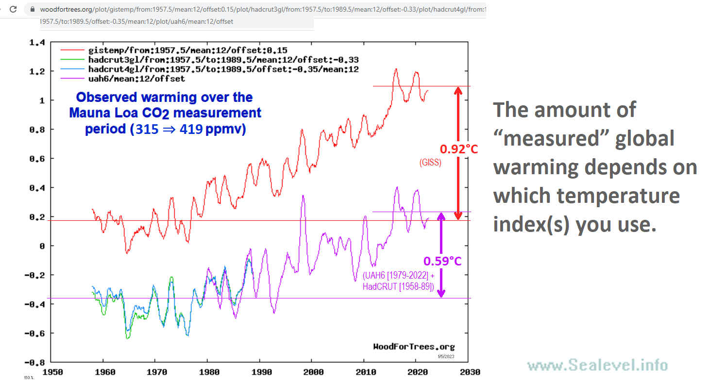
The temperature indexes are inconsistent, but you can't tell that from Priscian's misleading graph.
An honest graph would offset the traces so you can tell them apart, or else start them at the same temp. Instead he aligned the full-period averages, to hide the spread.
Here's what he's hiding:
What Jim Java / Priscian doesn't want you to notice is that the GISS (and Berkeley Earth, etc.) surface temperature indexes show much more warming than the UAH and NOAA STAR satellite-based lower troposphere measurements.
Land "surface" measurements are air temperatures measured with thermometers in Stevenson screens, usually 1.25 to 2 meters above ground. Satellite "lower troposphere" indexes (UAH, NOAA STAR, RSS) are from higher altitudes. Due to "lapse rate feedback," the (higher) altitudes where satellites measure temperatures should see a slightly greater warming trend than is seen 1.25 to 2 meters above the surface. Instead, they see less.
That's good cause to suspect that the surface temperature indexes from GISS etc. overstate warming.woodfortrees.org/plot/gistemp/f…
sealevel.info/GISS_vs_UAH_an…
sealevel.info/feedbacks.html…

2/8》
Do the math: 0.92 / 0.59 = 1.56
So, UAH6 & NOAA STAR satellite-based measurements suggest that those high-end surface temperature indexes are reporting at least 56% too much warming.
But even if it is exaggerated, the warming isn't worrisome. After all, humans are a tropical species, and most of the Earth is much too cold.
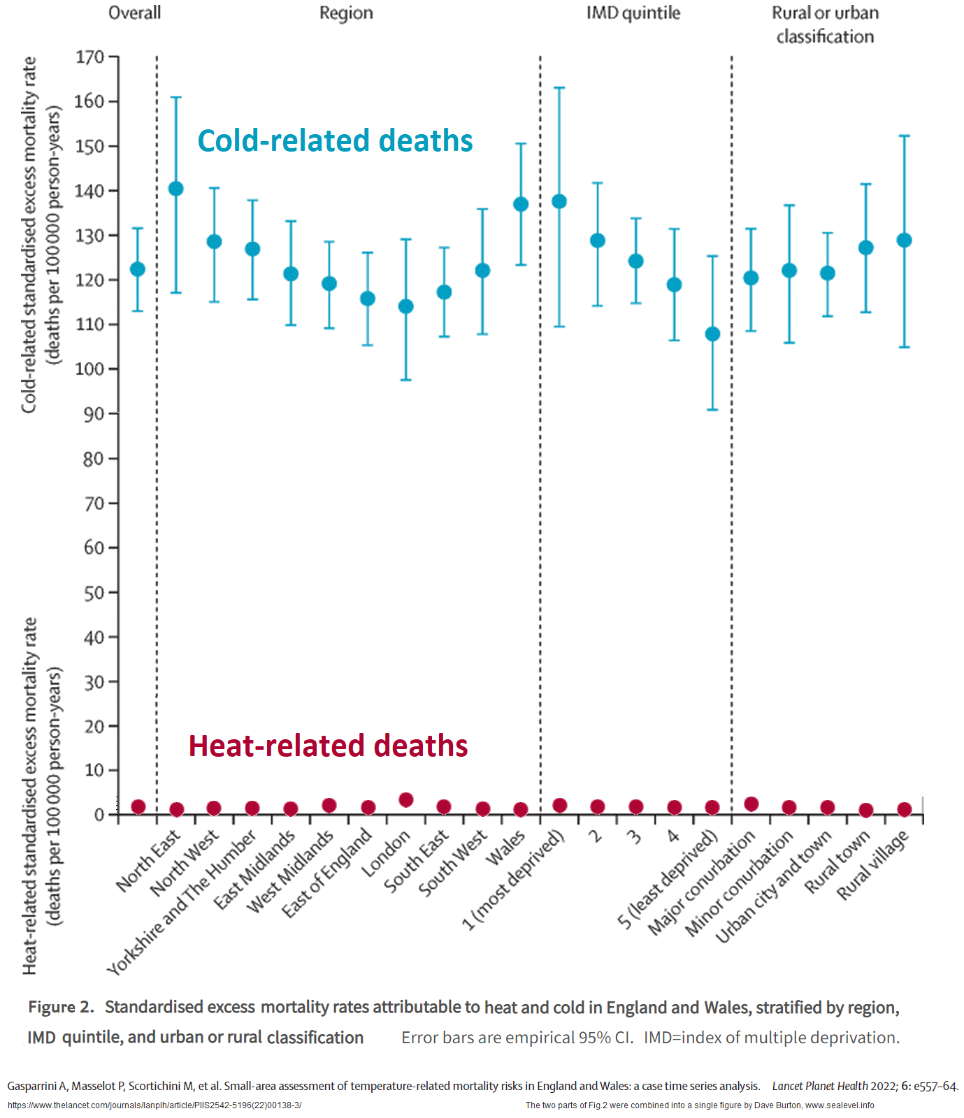
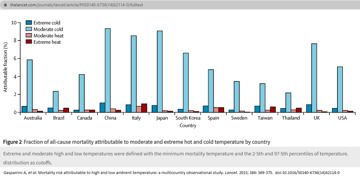
Warming saves lives, and excess cold causes many times more human deaths than excess heat — even in tropical counties, believe it or not! Here are some recent papers about it:
1. Masselot et al (2023).
2. Gasparrini et al (2022).
Composite of two figures from the paper:
3. Zhao et al (2021).
Discussion:
Summary:
4. Gasparrini et al (2015).
Fig. 2:
Are you familiar with the term "climate optimum?" If you go to ResearchGate or Google Scholar, and search for "Climate Optimum" (or Eemian Optimum, Mid-Holocene Optimum, Roman Optimum, or Medieval Optimum), you'll find thousands of papers using that terminology. Those "optimums" were warm periods.
The reason so many academic papers call the warmest periods in history "climate optimums" is that there is a consensus among historians and scientists that those warm "climate optimums" — including periods warmer than now — were, by all objective measures, better than colder periods.
Or, look at the flip side: cold periods, like the Dark Ages Cold Period (DACP) and the Little Ice Age (LIA). There's a broad consensus that those cold periods were, by all objective measures, worse for humanity than the warm "optimums."
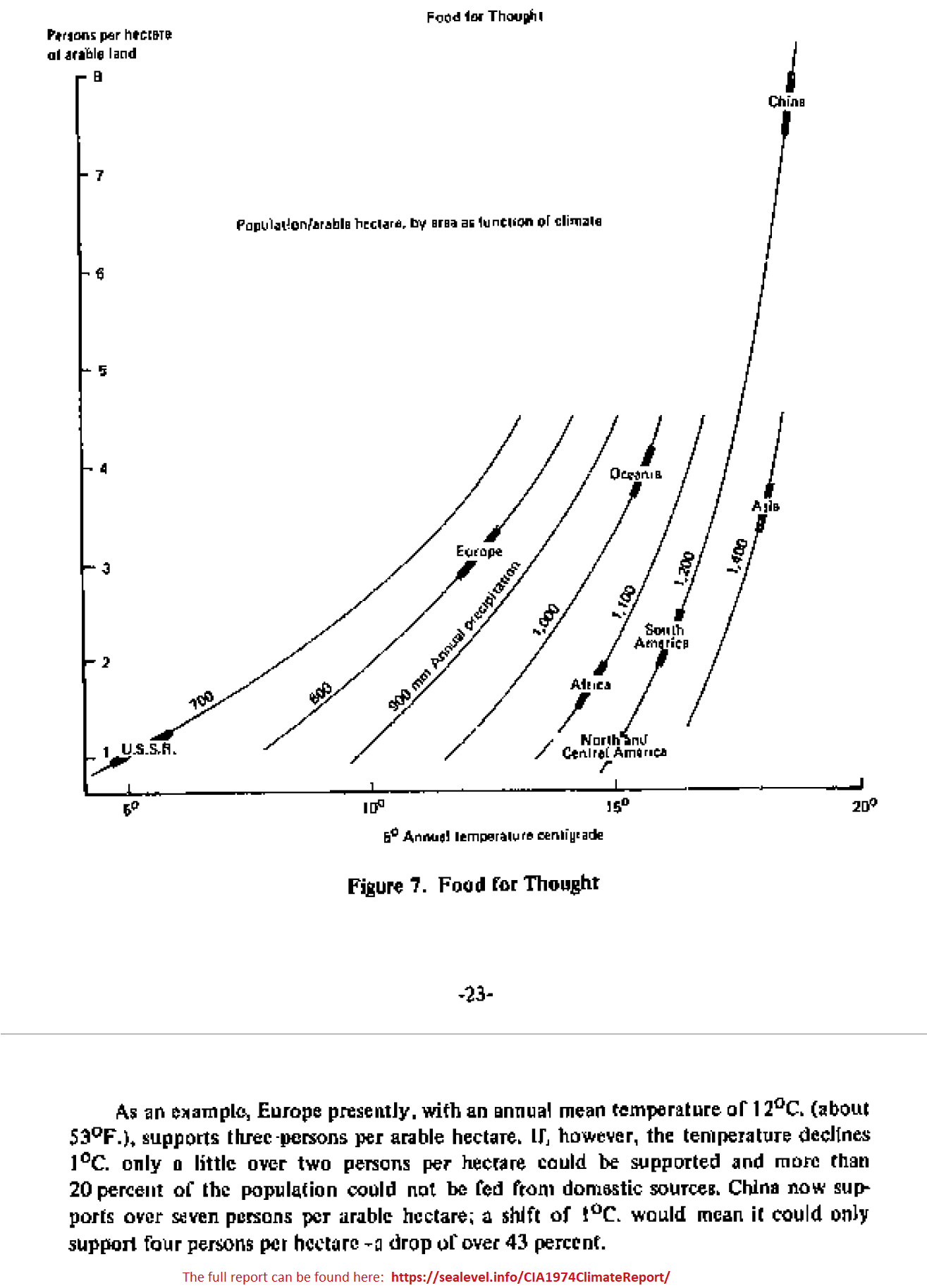
Here's a 1974 CIA study about the threat of global cooling:
This graph from that study shows how cooling temperatures threaten food supplies:
There are no important negative impacts from anthropogenic warming.sealevel.info/GasparriniFig2…
thelancet.com/journals/lanpl…
thelancet.com/journals/lanpl…
sealevel.info/GasparriniFig2…
thelancet.com/journals/lanpl…
unherd.com/thepost/bjorn-…
sealevel.info/Zhao2021_Lance…
thelancet.com/journals/lanpl…
sealevel.info/Gasparrini2015…
scholar.google.com/scholar?as_sdt…
scholar.google.com/scholar?as_yhi…
sealevel.info/CIA1974Climate…
sealevel.info/CIA1974Climate…
Do the math: 0.92 / 0.59 = 1.56
So, UAH6 & NOAA STAR satellite-based measurements suggest that those high-end surface temperature indexes are reporting at least 56% too much warming.
But even if it is exaggerated, the warming isn't worrisome. After all, humans are a tropical species, and most of the Earth is much too cold.
Warming saves lives, and excess cold causes many times more human deaths than excess heat — even in tropical counties, believe it or not! Here are some recent papers about it:
1. Masselot et al (2023).
2. Gasparrini et al (2022).
Composite of two figures from the paper:
3. Zhao et al (2021).
Discussion:
Summary:
4. Gasparrini et al (2015).
Fig. 2:
Are you familiar with the term "climate optimum?" If you go to ResearchGate or Google Scholar, and search for "Climate Optimum" (or Eemian Optimum, Mid-Holocene Optimum, Roman Optimum, or Medieval Optimum), you'll find thousands of papers using that terminology. Those "optimums" were warm periods.
The reason so many academic papers call the warmest periods in history "climate optimums" is that there is a consensus among historians and scientists that those warm "climate optimums" — including periods warmer than now — were, by all objective measures, better than colder periods.
Or, look at the flip side: cold periods, like the Dark Ages Cold Period (DACP) and the Little Ice Age (LIA). There's a broad consensus that those cold periods were, by all objective measures, worse for humanity than the warm "optimums."
Here's a 1974 CIA study about the threat of global cooling:
This graph from that study shows how cooling temperatures threaten food supplies:
There are no important negative impacts from anthropogenic warming.sealevel.info/GasparriniFig2…
thelancet.com/journals/lanpl…
thelancet.com/journals/lanpl…
sealevel.info/GasparriniFig2…
thelancet.com/journals/lanpl…
unherd.com/thepost/bjorn-…
sealevel.info/Zhao2021_Lance…
thelancet.com/journals/lanpl…
sealevel.info/Gasparrini2015…
scholar.google.com/scholar?as_sdt…
scholar.google.com/scholar?as_yhi…
sealevel.info/CIA1974Climate…
sealevel.info/CIA1974Climate…

3/8》
Depending on whose temperature index you use, we’ve seen an average of between 0.59 and 0.92 °C of warming since 1958 (when Mauna Loa CO2 measurements began).
That warming has shifted growing zones and “temperature isotherms” slightly toward the poles (northward, in the NH). So, the obvious question is, how far?
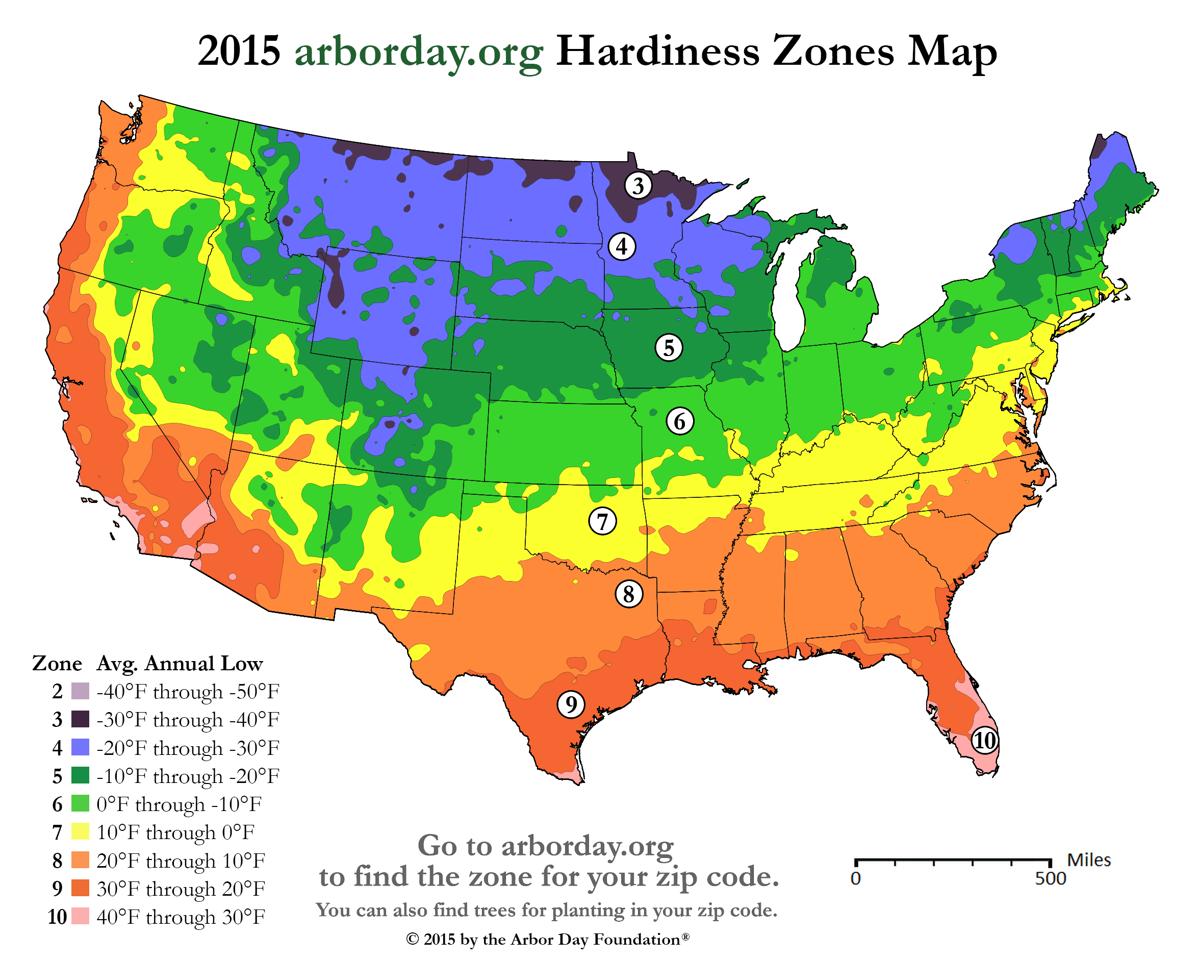
That’s easy to answer, by looking at an agricultural growing zone map. Here's one, shared by permission from the Arbor Day Foundation:
From eyeballing the map, you can see that 1°C (1.8°F) = about 50-70 miles latitude change.
Here's James Hansen and his GISS colleagues reporting a similar figure:
Excerpt: "A warming of 0.5°C... implies typically a poleward shift of isotherms by 50 to 75 km..."
That's 100 to 150 km = 62 to 93 miles per 1°C. So, the 0.59 to 0.92 °C of warming which we've seen has caused, on average, a growing zone shift of only about 30 to 86 miles). Ho hum.🥱woodfortrees.org/plot/gistemp/f…
sealevel.info/GISS_vs_UAH_an…
sealevel.info/2015_zones_hig…
pubs.giss.nasa.gov/abs/ha02700w.h…
Depending on whose temperature index you use, we’ve seen an average of between 0.59 and 0.92 °C of warming since 1958 (when Mauna Loa CO2 measurements began).
That warming has shifted growing zones and “temperature isotherms” slightly toward the poles (northward, in the NH). So, the obvious question is, how far?
That’s easy to answer, by looking at an agricultural growing zone map. Here's one, shared by permission from the Arbor Day Foundation:
From eyeballing the map, you can see that 1°C (1.8°F) = about 50-70 miles latitude change.
Here's James Hansen and his GISS colleagues reporting a similar figure:
Excerpt: "A warming of 0.5°C... implies typically a poleward shift of isotherms by 50 to 75 km..."
That's 100 to 150 km = 62 to 93 miles per 1°C. So, the 0.59 to 0.92 °C of warming which we've seen has caused, on average, a growing zone shift of only about 30 to 86 miles). Ho hum.🥱woodfortrees.org/plot/gistemp/f…
sealevel.info/GISS_vs_UAH_an…
sealevel.info/2015_zones_hig…
pubs.giss.nasa.gov/abs/ha02700w.h…

4/8》
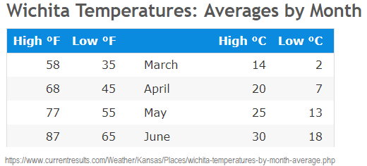
In most places that much warming can be compensated for by farmers, simply by adjusting planting dates. For example, in Kansas, 1°C of warming can be compensated for by planting about 6 days earlier in springtime:
Obviously, the slight measured warming trend does not support the "climate emergency" narrative.sealevel.info/wichita_spring…

5/8》
Worse than the disagreement between different temperature indexes is the disagreement between different versions of the SAME temperature index, due to revisions made to the "measured" data.
That's one of the main reasons Tony Heller @TonyClimate (and others) think there's a thumb on the scale.
Do you remember this?
"...it is clear that 1998 did not match the record warmth of 1934..." [in the USA]
– James Hansen et al (circa 1999)
paos.colorado.edu/~fasullo/1060/…
Worse than the disagreement between different temperature indexes is the disagreement between different versions of the SAME temperature index, due to revisions made to the "measured" data.
That's one of the main reasons Tony Heller @TonyClimate (and others) think there's a thumb on the scale.
Do you remember this?
"...it is clear that 1998 did not match the record warmth of 1934..." [in the USA]
– James Hansen et al (circa 1999)
https://twitter.com/ncdave4life/status/1720036103204245874
paos.colorado.edu/~fasullo/1060/…
6/8》
In the 1970s, measured surface temperature data showed a global 0.35°C decline, over roughly 30 years.
Here's a 1975 Newsweek article which credited NCAR, and showed a similar trend for the northern hemisphere alone:
sealevel.info/newsweek_old.h…
In the 1970s, measured surface temperature data showed a global 0.35°C decline, over roughly 30 years.
Here's a 1975 Newsweek article which credited NCAR, and showed a similar trend for the northern hemisphere alone:
https://twitter.com/ncdave4life/status/1533610324347211777
sealevel.info/newsweek_old.h…

7/8》
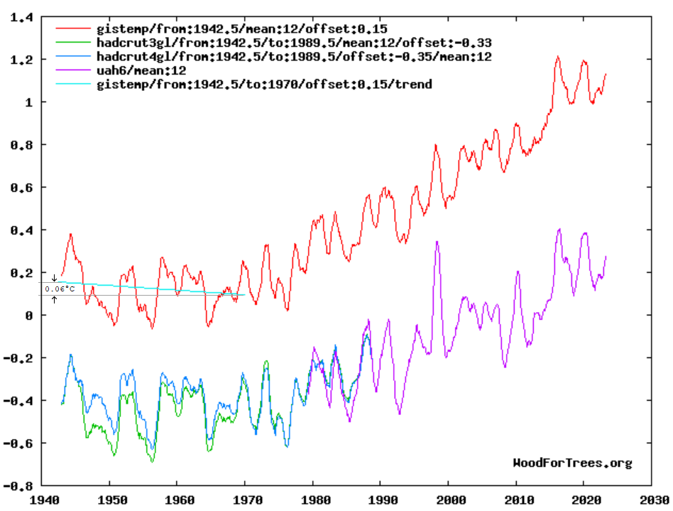
The problem is that GISS now admits to only a minuscule 0.06°C cooling during that period:
0.35 / 0.06 = almost a factor of 6. They've revised-away 5/6 of the previously measured cooling trend, from the 1940s to the 1970s.woodfortrees.org/plot/gistemp/f…
sealevel.info/GISS_vs_UAH_an…
The problem is that GISS now admits to only a minuscule 0.06°C cooling during that period:
0.35 / 0.06 = almost a factor of 6. They've revised-away 5/6 of the previously measured cooling trend, from the 1940s to the 1970s.woodfortrees.org/plot/gistemp/f…
sealevel.info/GISS_vs_UAH_an…

8/8》
Then, as icing on the cake, as if confidence in the climate science community weren't low enough already…
Then, as icing on the cake, as if confidence in the climate science community weren't low enough already…
https://twitter.com/ncdave4life/status/1720270610838810850
@GneissName @Willard1951 @Anvndarnamn5 @EthonRaptor @AristotleMrs @priscian @Veritatem2021 @annmclan @FD2you @DawnTJ90 @BradPKeyes @Callan23474387 @Mark_A_Lunn @KCTaz @0Sundance @TheDisproof @BointonGiles @DoesThisW0rk @3GHtweets @Climatehope2 @Jaisans @S_D_Mannix @TWTThisIsNow @JustThi30117912 @paulp1232 @MartinJBern @Data79504085 @ShroedingerBird @ammocrypta @ChrisBBacon3 @B_Bolshevik100 @rosmadiwahab @Robert76907841 @EricWil06256732 @ProfMickWilson @FillmoreWhite @TommyLambertOKC @JohnDublin10 @NoTricksZone @RoelofBoer @DawnJT90 @DawnTj9 @PeterDClack @FriendsOScience @Kenneth72712993 @wattsupwiththat Compilation:
@ThreadReaderApp @Rattibha @threaddotblue unroll
@reSeeIt save threadtwitter-thread.com/t/174354436006…
@ThreadReaderApp @Rattibha @threaddotblue unroll
@reSeeIt save threadtwitter-thread.com/t/174354436006…
• • •
Missing some Tweet in this thread? You can try to
force a refresh


