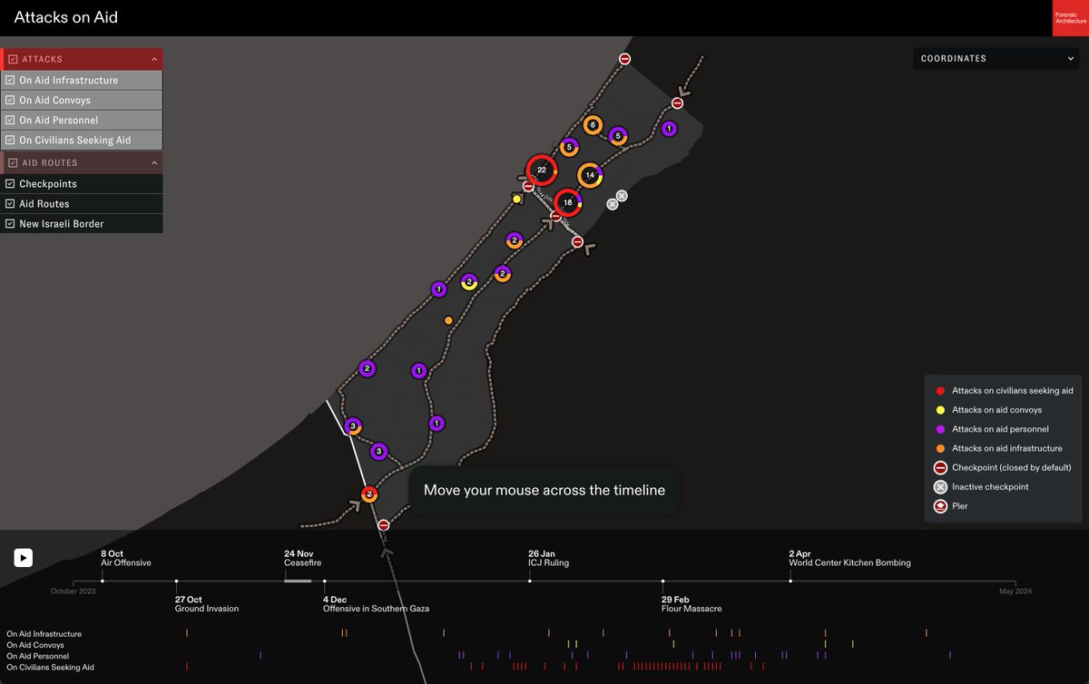
NEW: Our analysis of reported data identifies at least 80 separate attacks by Israel on aid in Gaza since January. The frequency and widespread nature of these attacks suggests that Israel is systematically targeting aid.
Reports indicate at least 37 attacks on civilians seeking aid, all near the Israeli-controlled checkpoints on Salah al-Din Street and al-Rashid Street.
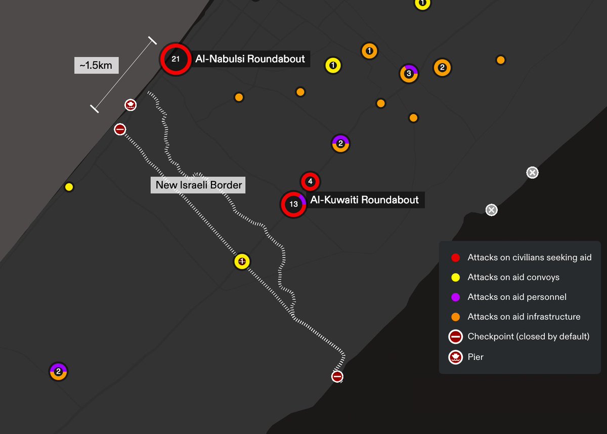
These findings are preliminary and non-exhaustive. We will update the map as our research progresses on Israel’s systematic attack on aid. See our interactive map on aid attacks here: …aid-attacks.forensic-architecture.org
• • •
Missing some Tweet in this thread? You can try to
force a refresh
NEW INVESTIGATION: Since Oct '23, the Israeli military has systematically targeted agricultural land and infrastructure in Gaza. To mark Land Day in Palestine, we present our analysis of this widespread destruction as an act of ecocide that supports Israel’s genocidal campaign.
We used remote sensing to measure the scale of agricultural destruction by comparing the region’s ‘vegetation index’ before and after the ground invasion. Our analysis reveals that as of Mar 2024, ~40% of the land in Gaza previously used for food production has been destroyed.
Agricultural infrastructure has also been targeted in the present invasion. Our analysis reveals that since Oct 2023, ~1/3 of Gaza’s greenhouses have been destroyed. We identified >2000 sites where entire farms were uprooted, often replaced by Israeli army earthworks.
NEW INVESTIGATION: Since 7 Oct 23, the Israeli army has weaponised humanitarian measures such as ‘evacuation orders’, ‘safe routes’ & ‘safe zones’ to support their military operations & facilitate the mass displacement of Palestinians.
Our analysis reveals how Israel's systematic displacement of Palestinians, towards areas already rendered unliveable by attacks on critical civilian infrastructure, has occurred in three phases.
Phase 1 began 13 Oct, when the Israeli army ordered 1.1M Palestinians in the area north of Wadi Gaza to evacuate within 24h. A new 'border' checkpoint on Salah al-Din Street enforced the new north/south divide and prevented displaced Palestinians from returning.
NEW REPORT: We analysed the visual material presented by Israel at the @CIJ_ICJ hearing on 12 Jan '24. We found 8 instances of the Israeli legal team misrepresenting materials presented through incorrect annotations and misleading descriptions. Full report forensic-architecture.org/investigation/…
A few examples to follow: 1) Israel’s legal team referenced an annotated drone image to claim Al-Quds hospital was used for military purposes and thus a justified target. We found the hospital boundary annotation was incorrect and no evidence of armed operations inside al-Quds.
2) The Israeli legal team incorrectly identified an annotated image of a crater as a Palestinian rocket launch site. We geolocated, modelled and measured the crater, finding it consistent with the impacts of Israeli bombs between 500 and 1000 lbs.
Our latest findings on the al-Ahli hospital blast: using 3D trajectory analysis, we dispute the Israeli military’s claim that the hospital was struck by a misfiring Palestinian rocket from a salvo of 17, with most of the damage caused by unspent rocket propellant.
Our analysis shows that all 17 rockets travelled 1.8-2km at 500-630m/s and stopped flaring at a 1km altitude, ~4km west of al-Ahli. According to an aerospace expert, these figures indicate that all rockets would have finished burning their propellant while still in mid-flight.
These recent findings follow our previous analysis, which debunked claims made by an Israeli spokesperson about two videos he alleged showed the rocket responsible for the hospital blast:
Our aggregation of news reports since 7 Oct suggests that hospitals in Gaza are subjected to a repeated pattern of intimidation, direct targeting, siege, and occupation by the Israeli military: …a-hospitals.forensic-architecture.org
Al-Shifa Hospital, the largest in Gaza, has been subjected to this systematic process of destruction and depopulation. We brought together open-source evidence to tell its horrifying story day by day: shifa.forensic-architecture.org
Our partners at @alhaq_org have documented a similar pattern of attacks on Gaza’s Indonesian Hospital: indonesian.alhaq.org
One of Gaza’s most important archaeological sites—threatened previously by Israeli bombings/siege—has been mostly destroyed in the Israeli invasion. The site, near al-Shati refugee camp, consists of several excavations which suggest extensive remains throughout the area:
The present destruction of the site by the IOF has unfolded in three stages: (1) airstrikes, (2) surface-level demolition, and now (3) the installation of water pumps ostensibly to flood underground tunnels.
Satellite imagery shows that between 8 Oct and the start of the ground invasion in Nov, the site was riddled w dozens of craters from airdropped munitions. By 6 Nov, the extent of the site had been subject to 30+ craters (in red) ranging 8-16m in diameter.