
🚨I'm calling all J6 Pipe Bomber detectives to Fight Fight Fight! 🧵
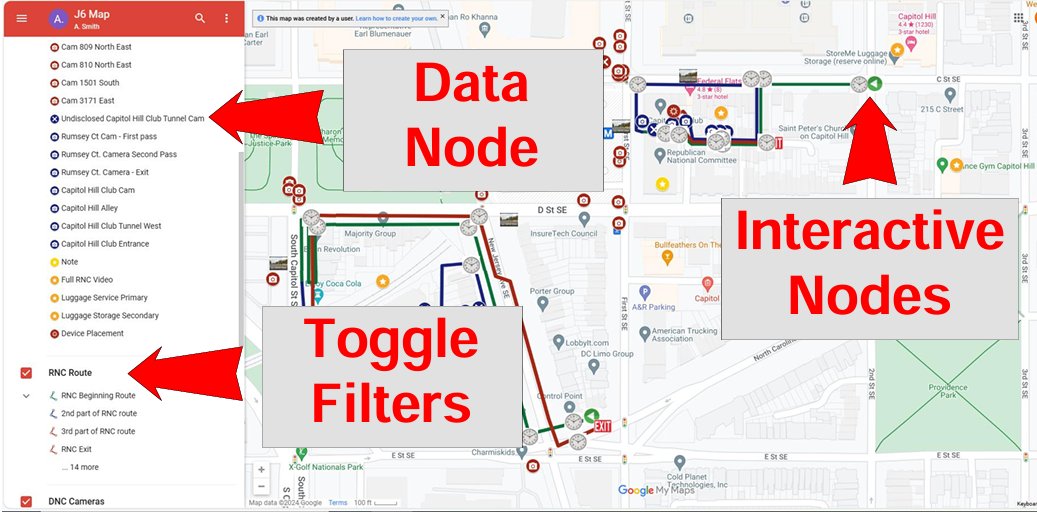
I have compiled EVERY data point regarding the J6 pipe bomber into a publicly available interactive map! I have discovered something very important from this data, which will be covered in the following posts.
This map includes...
1. Every publicly available camera and image of the pipe bomber.
2. Previews and links to every camera and image.
3. Notes that take you directly to every timestamp where the suspect is seen.
4. Timestamps for every portion of the route the suspect took.
5. Links that take you directly to streetview.
6. Shows undisclosed cameras.
7. Composite surveillance video showing the complete route the bomber took in a single video file.
8. Map can be updated live with new information.
Google map link 👉
I have attached instructions on how to use this map as well as a legend. I have data outside this boundary that is available upon request. Post your findings, requests, and questions below.
💪Work that needs to be done
Every time stamp that we would expect to see the bomber has been tagged. What we need to look for now, is the bomber showing up in unexpected places. In particular the Capitol South Metro.
⭐️I have ZERO reach on X. If you find this tool useful, retweet it, so that we can get the entire internet on this data. Otherwise, no one will see this.t.co/ffzPlqHy35

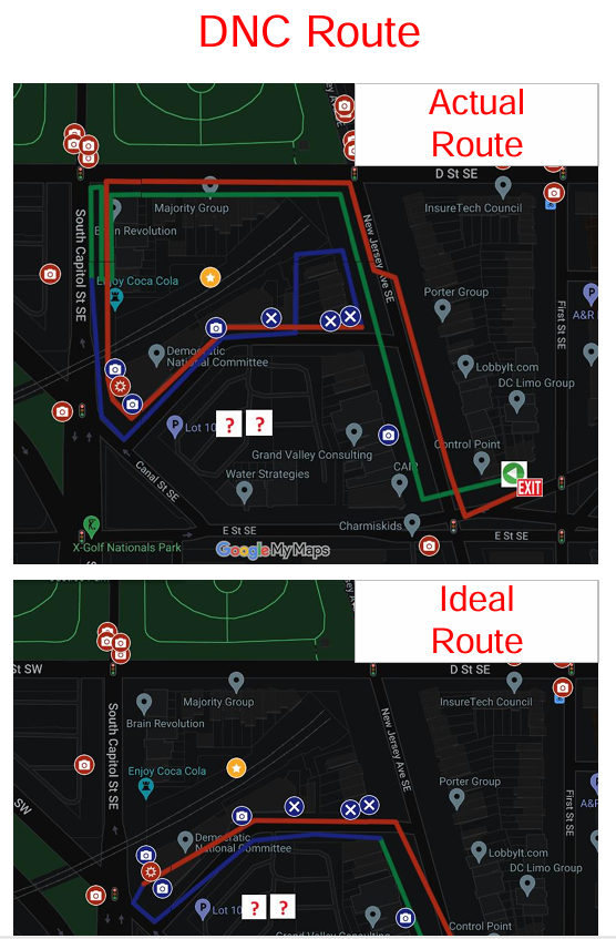
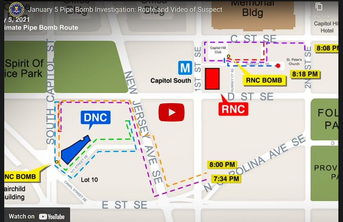
This data reveals something very important. We can see from this data that the spiral pattern the bomber took around the RNC and the DNC serves no purpose except in parading themselves across capitol police cameras.
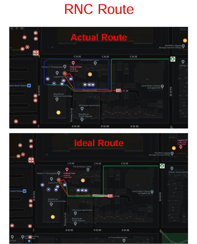
Below you will find two images. One for the DNC, one for the RNC. Each individual image shows their actual route, compared to an ideal route that would avoid capitol police cameras. Capitol police cameras are in red, non-capitol police cameras are in blue. (Note the Library of Congress is on a different program from that the capitol police use. Further, Capitol Police Cam 3173 at the DNC was turned away from the drop off) The ideal route for the RNC would avoid ALL capitol police cameras. The ideal route for the DNC avoids all but one, and even that one could be avoided by NOT crossing the street.
Keep in mind these aren't just cameras!! There are Capitol Police officers stationed here. Some of these have 3 officers stationed!
Bottom line.
People who intend to plant live explosives DO NOT parade themselves in front of LAW ENFORCEMENT CAMERAS!!! This person wanted to be on camera. They had an explosive with a phony detonator, and we can now say with certainty that they wanted to be seen but not identified.
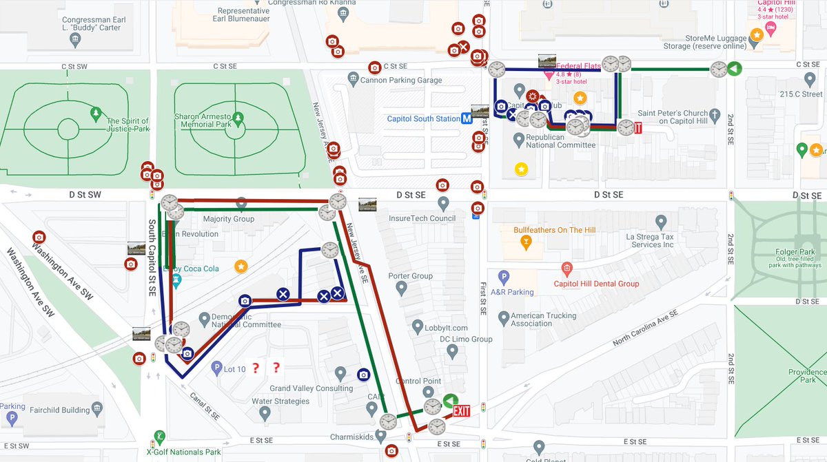
This research has also revealed that the FBI's official route around the DNC includes a major error. The FBI shows the bomber making a second pass going north on NJ Ave (seen in blue below). However, if you watch the attached video, at 5 minutes in, you will see the suspect heading out of the bushes toward the NJ Ave sidewalk, then they return to the bushes, then they come back out of the bushes and start heading south on NJ Ave.
It's almost like the suspect was second guessing the route they were supposed to take. "Oops, I'm not supposed to go clockwise". "I should be entering from here...not exiting". "Oh well, I'm already here, guess I'll proceed". I'm speculating on their thoughts here...but it seems odd that both the suspect and the FBI become confused about this particular point.
On their final pass to exit the DNC route they stop and look at these bushes. I have no idea why.
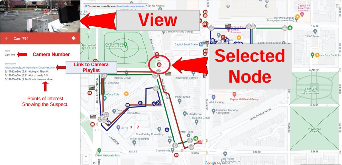
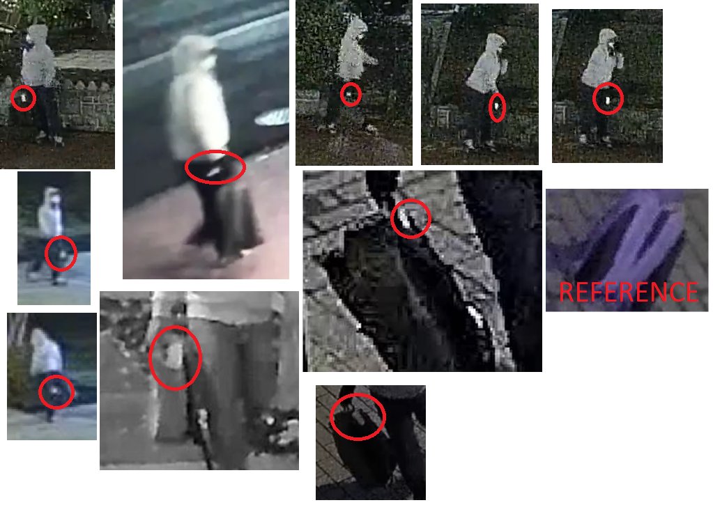
Here is a third thing that this data has revealed. Having compiled all the available video, and discovering new video, I have discovered a development in the behavior of the pipe bomber. Both at the DNC and the RNC, the bomber carries the backpack in their hand away from them so that they do not jostle the backpack. We can see on the row house video, cam 4400 on your map, that the suspect places the backpack down gently...as if it's full of eggs.
What I discovered is that at both the RNC and the DNC, the bomber acts as if they are carrying a live explosive. However, that concern ends after they place the bomb. After they place the bomb at the DNC, and after they place the bomb at the RNC, the suspect begins wearing the backpack. They discontinue their concern over the backpack...and begin wearing it. That means two things.
1. There is only 1 bomb in the backpack at a time.
2. There is a pick-up location.
Number 2 especially makes sense given that, according to @KyleSeraphin, the bomber used the metro. The D.C. metro does random bag searches. Wearing a hoodie, a mask, glasses/sunglasses (watch the 1st note on cam 4400) through the metro while carrying a backpack away from your body like a bomb is a good way to go to jail.
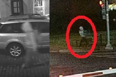
Image on the left is from Rumsey ct. (see "Rumsey CT. Camera Exit" on your map). The image on your right is from the corner of NJ Ave and D street (Cam 795, 3rd note on your map)
What I discovered is that at both the RNC and the DNC, the bomber acts as if they are carrying a live explosive. However, that concern ends after they place the bomb. After they place the bomb at the DNC, and after they place the bomb at the RNC, the suspect begins wearing the backpack. They discontinue their concern over the backpack...and begin wearing it. That means two things.
1. There is only 1 bomb in the backpack at a time.
2. There is a pick-up location.
Number 2 especially makes sense given that, according to @KyleSeraphin, the bomber used the metro. The D.C. metro does random bag searches. Wearing a hoodie, a mask, glasses/sunglasses (watch the 1st note on cam 4400) through the metro while carrying a backpack away from your body like a bomb is a good way to go to jail.
Image on the left is from Rumsey ct. (see "Rumsey CT. Camera Exit" on your map). The image on your right is from the corner of NJ Ave and D street (Cam 795, 3rd note on your map)
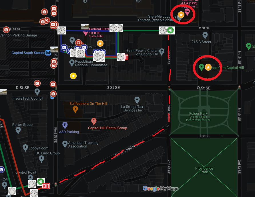
The fourth thing this data reveals is that the suspect's backpack had what appears to be a luggage tag attached to the top handle of the backpack. We know from @KyleSeraphin's personal FBI experience in the FBI working on this case, that the person took the metro and lives in Northern Virginia. This is not an airplane tag. I believe that this is a tag for one of three possible luggage services in D.C., "Stasher", "StoreMe", or "Bounce".
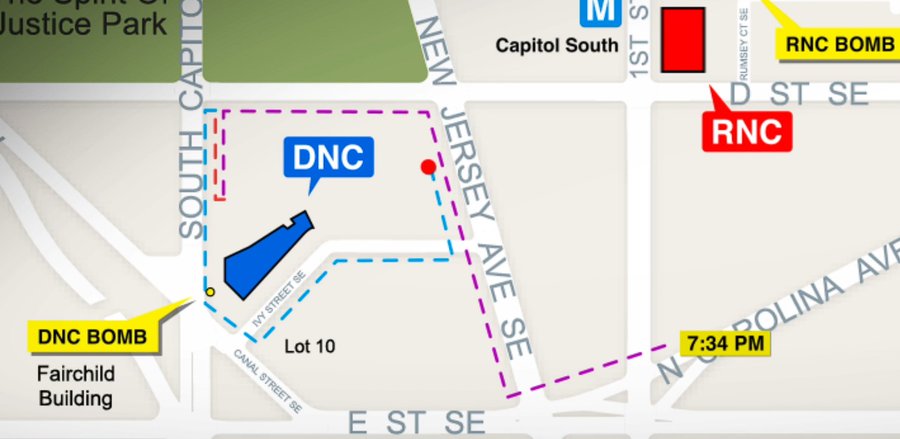
Take a look at the official route below. Why take North Carolina Ave to approach the RNC from behind and to the north? The direct route is up 1st street and the only additional camera that route would include is Cam 3171. So why take such an inexplicable route? I can't know for certain, but I can tell you that all 3 of these services operate alongside the inexplicable route the suspect takes.
Recall that the Metro does random bag checks, and the suspect is at peak suspicion. The best plan for this OP is to already have the bombs stashed in D.C. and planted by someone with no direct ties to the bomb except in depositing it.
The dotted red line in the image below is the ostensible route that the bomber took along N.C. Ave and 2nd Street. The two places I have circled show where these luggage services exist on this map.
I speak about this in more detail, and describe how much time could be available to make this pick-up in the 🧵here 👉
What we really need now is for a reporter to investigate what kind of tags these services use. Some of these tags can be seen online, but there is a problem with that...these are all franchises operating privately around the world and this franchise could be using a tag completely different from the next franchise. (Important No one should act on their own, this needs to be done by a legitimate reporter)
https://x.com/accabbat/status/1829845357087637550
• • •
Missing some Tweet in this thread? You can try to
force a refresh


