Flooding disaster unfolding right now in Central Europe.
Why is it so bad?
This thread takes a quick look at some of the key ingredients of this record-breaking storm.

Why is it so bad?
This thread takes a quick look at some of the key ingredients of this record-breaking storm.


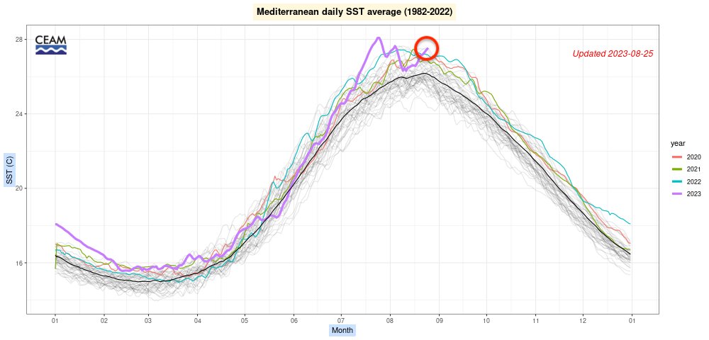
Let’s start with the background. It has been an exceptional Summer for the Mediterranean Sea. Heat records have been broken.
Warmer sea surface temperatures allow more moisture to evaporate, like fuel for a storm. The warmer the water, the greater the evaporation…
Warmer sea surface temperatures allow more moisture to evaporate, like fuel for a storm. The warmer the water, the greater the evaporation…
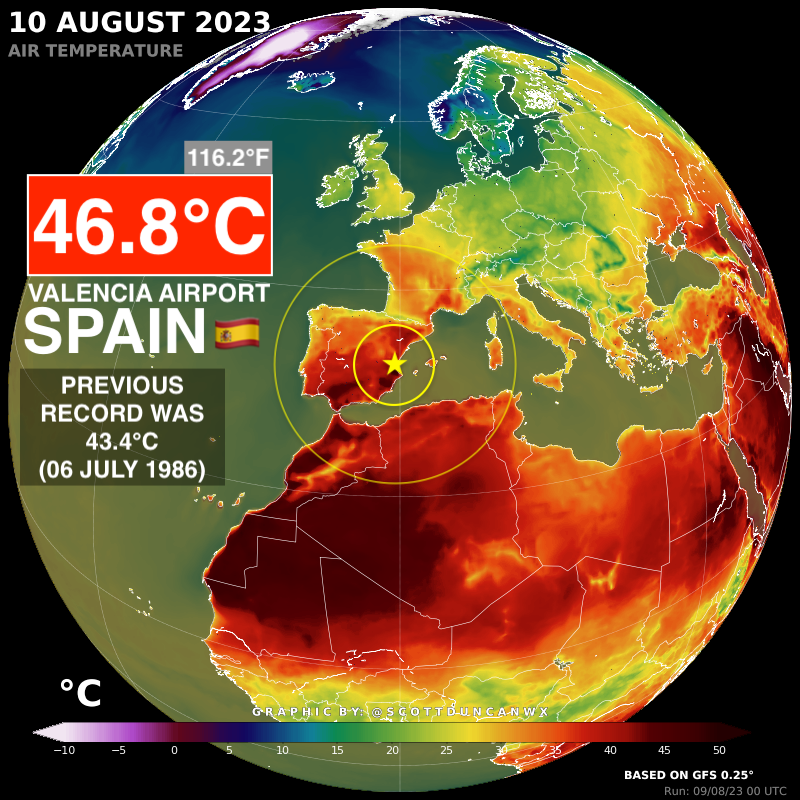
We then had a historic cold wave (for this early in September) plunge south out of the Arctic and through Europe.
We now have an unprecedented combination of hot and cold (ideal for strong thermal boundaries/weather fronts).
We now have an unprecedented combination of hot and cold (ideal for strong thermal boundaries/weather fronts).
This plunge of cold was part of a cyclonic wave break, essentially cutting-off a low pressure from the main background flow.
This means a low pressure (storm) can get trapped and sit in the same place for days.
This means a low pressure (storm) can get trapped and sit in the same place for days.
Before getting into any detail... The background ingredients for European weather support an extreme combination of variables which can get trapped for days.
Alarm bells should be ringing already ⚠️
Alarm bells should be ringing already ⚠️
Why Central Europe?
We should never forget about the proximity of the high pressures. Really crucial players holding this weather event over Central Europe.
We should never forget about the proximity of the high pressures. Really crucial players holding this weather event over Central Europe.

Why is this pressure gradient important? Rain (or snow) events can get an extra kick when there are mountains involved. This is known as orographic enhancement. You can learn more about orograophic precipitation events here: britannica.com/science/orogra…

The precipitation stacked up along the strong thermal boundary, held in place by important areas of high pressure and enhanced by the orography.
The rain is still falling but we already know Austria rainfall records are being pulverised (more on that when the dust settles).
The rain is still falling but we already know Austria rainfall records are being pulverised (more on that when the dust settles).
Was this disaster captured in weather forecasts?
Yes. Many weather models were flagging this several days in advance. Weather models were resolving historic flood event (pretty much a worst case scenario) before the rain even started to fall.
Yes. Many weather models were flagging this several days in advance. Weather models were resolving historic flood event (pretty much a worst case scenario) before the rain even started to fall.
https://x.com/JZ_Lpz/status/1835353554795569194
A closer look at the precipitable water shows how the atmospheric moisture sweeps through the Mediterranean and becomes focused in the Black Sea (which is also much hotter than normal).
The moisture then wraps around the storm, like an atmospheric river.
The moisture then wraps around the storm, like an atmospheric river.
In my personal opinion, the key takeaways here are:
- Strong cold clashing with immense sources of heat and available moisture
- Trapped weather pattern held in place and boosted by high pressure nearby
- Black Sea atmospheric river
- Orographic enhancement
- Strong cold clashing with immense sources of heat and available moisture
- Trapped weather pattern held in place and boosted by high pressure nearby
- Black Sea atmospheric river
- Orographic enhancement
I am not here to get into the details of how water is managed. This is a factor which is important for impact.
The bottom line here is that parts of Central Europe have never recorded a weather event like this. Not just in September, but for any month.
The bottom line here is that parts of Central Europe have never recorded a weather event like this. Not just in September, but for any month.
https://x.com/wetterblogAT/status/1835199826629108016
• • •
Missing some Tweet in this thread? You can try to
force a refresh