NEW: ‘A Cartography of Genocide’. Since October 2023, we have collected and analysed data related to Israel’s military campaign in Gaza. Our findings indicate that Israel has systematically targeted all aspects of civilian life. tinyurl.com/bdcrnzka
We present our findings in a report and an interactive platform, revealing how Israel’s military campaign has fundamentally reshaped Gaza. Much of this reshaping appears to embody in practice the statements of genocidal intent made by Israeli state and army officials and media. We found:
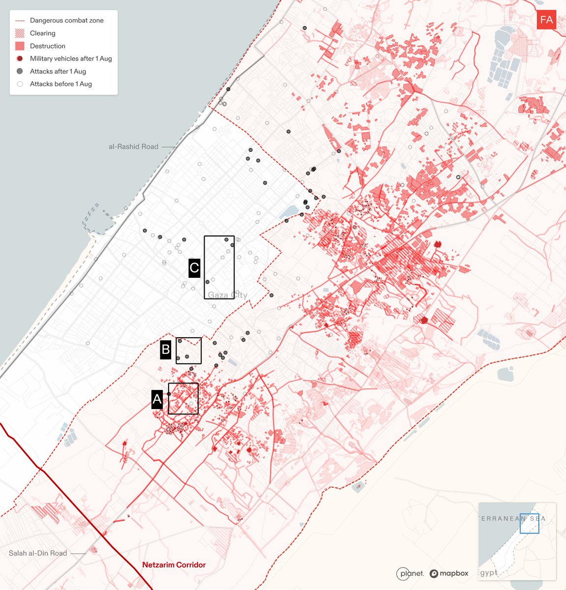
Israel has imposed a new system of spatial control on Gaza, destroying agricultural lands and buildings to create infrastructure that supports a long-term military presence, including roads, checkpoints and a 1 km-wide buffer zone.
Israel destroyed agriculture and water resources across Gaza, in many cases permanently damaging them and degrading the territory’s ability to sustain life. By 30 June, Israel had destroyed ~70% of agricultural land, 47% of groundwater wells and 45% of greenhouses in Gaza.
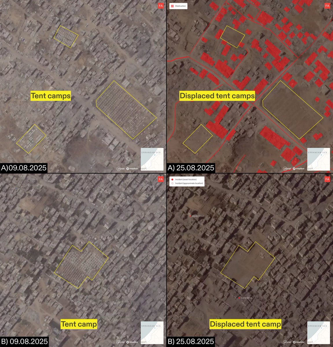
Israel weaponised ‘protective measures’, repeatedly ordering the displacement of civilians to areas of Gaza it then attacked, conducting deadly strikes within the constantly shifting boundaries of an Israeli-designated ‘humanitarian zone’.
Israel systematically dismantled Gaza’s healthcare infrastructure, attacking hospitals and targeting medical workers. By August, 35 of Gaza’s 36 hospitals had been forced out of service at least once, and at least 595 healthcare workers had been killed, and 300 arrested.
Israel repeatedly attacked civilian infrastructure in Gaza: 71% of known shelters, 53% of utilities, 75% of schools, 80% of religious institutions, 91% of cultural heritage sites have been destroyed or damaged.
Israel targeted sites and systems of humanitarian aid distribution when and where they became the primary mode of aid facilitation. We documented 322 such incidents, including targeted attacks on bakeries, shelters where aid was distributed, aid personnel, aid warehouses, and civilians trying to access aid.
To identify patterns across thousands of data points, we developed an interactive cartographic platform. This turns rows of data into a navigable map of Gaza, within which it is possible to define regions, periods in time, and select certain categories of events. See the platform here: gaza.forensic-architecture.org
The interrelated and compounding effects of these various dimensions of Israel’s assault on Gaza indicate a deliberate effort to render the territory incapable of supporting life, both in the present and in the long-term. Read our full report here: tinyurl.com/y4sbasrk
• • •
Missing some Tweet in this thread? You can try to
force a refresh
We’re honoured to announce a major new project supported by @wellcometrust.
UNLEARNING ‘EXCITED DELIRIUM’ brings together a world-class team to confront an urgent health, human rights, racial & social justice issue. Meet our partners below…
The project builds on decades of activism on race and policing by Stafford Scott, of @tottenhamrights and a Guest Professor with FA here at Goldsmiths. The seeds for this project were sown during 2021’s unforgettable WAR INNA BABYLON at @icalondon ica.art/exhibitions/wa…
In 2022, a major report by @p4hr exposed the racist origins of ‘Excited Delirium’ (ExD). Despite no scientific basis, ExD and its inheritor ABD are still often referred to when racialised men are killed by police.
Israel is besieging Gaza City from three directions, pushing the nearly 1m Palestinians currently sheltering there towards southern Gaza.
Each military advance flattens homes and infrastructure in its path, threatening the erasure of millennia-old Gaza City, and displacing the people sheltering there. Most of the areas in southern Gaza which the military have allocated for relocation are within ‘no-go’ zones, or in areas unsuitable for habitation.
Israeli troops are advancing towards Gaza City from three directions: Jabalia in the north, Shujaiya in the east, and—most recently—the Netzarim Corridor in the south. This leaves Palestinians with only one place to go: towards the coast, along al-Rashid Road and into southern Gaza.
A comparison of satellite images from 9 and 25 August reveals the rapid dismantling of dense tent camps in Gaza City as Israel’s ground invasion has advanced. Meanwhile, tents, homes, markets, and community kitchens in the rest of the city have instead been subject to relentless bombardment, leaving the besieged, starving population with few options but to flee south.
NEW: Salman Abu Sitta is a Nakba survivor and historian of Palestine. Together, we digitally reconstructed his birthplace, the village of al-Ma’in, exploring its history and documenting how, in 1948, the village was destroyed and its people forcibly expelled: forensic-architecture.org/investigation/…
On 14 May 1948, al-Ma’in was occupied and demolished by Zionist forces.
We reconstructed the village to uncover its layered history — from its vibrant agricultural life, with a 95-metre deep well and a bayarah, to the 60,000 dunams (15,000 acres) of land cultivated by the Abu Sitta family, mostly wheat and barley.
FA has documented a pattern of Israeli attacks on areas into which they have previously instructed civilians in Gaza to evacuate. Our research confirms that the Israeli military carried out multiple attacks in areas towards which civilians had been directed, either on the same day as the evacuation order, or on the day after. See more: frames.forensic-architecture.org/gaza/updates/a…
1) On the morning of 23 Mar 2025, the Israeli military issued an evacuation order for Tel al-Sultan neighbourhood of Rafah, directing civilians to move northeast. That evening, there was an airstrike northeast of Tel al-Sultan, in Khan Younis, that hit the Nasser Medical Complex, the largest hospital in the area.
2) On the morning of 7 Apr 2025, the Israeli military issued an evacuation order to Deir al-Balah, directing civilians to move southwest. Later that day, there was an attack on a residential building southwest of Deir al-Balah. The following day, there were two attacks in areas southwest of Deir al-Balah.
Israel has designated the majority of the Gaza Strip for evacuation. 34 evacuation orders have been issued to civilians in Gaza since the dissolution of the ceasefire on 18 March 2025. Many of these orders define differing boundaries for the militarised buffer zone in the east of Gaza, gradually expanding the area designated for evacuation. See more: frames.forensic-architecture.org/gaza/updates/i…
We have documented 4 instances where the declared boundaries of the buffer zone have subsumed areas previously subject to evacuation orders. As of 3 June 2025, the buffer zone has expanded to encompass the municipality of Rafah, as well as areas to the east of Khan Younis and in the north of Gaza.
For example, an evacuation order was issued to the municipality of Rafah on 31 March and 1 April. In an evacuation order issued on 6 April, the declared buffer zone expanded to encompass the areas previously designated for evacuation.
Israel is constructing a second militarised ‘corridor’ in Gaza, to expand their control of the Strip. Plans for the Morag Corridor were announced on 2 April; since that time, we’ve identified widespread destruction throughout the remains of Rafah city, and several new Israeli military outposts. Follow this developing situation in our new mapping portal: frames.forensic-architecture.org/gaza/updates/m…
A comparison of satellite imagery from 3 April and 11 May reveals how entire areas of central Rafah have been destroyed by the Israeli military.
During the same timeframe, the Israeli military destroyed dozens of buildings and greenhouses, as well as agricultural land, to the north of Rafah, to make way for the construction of the Morag Corridor.