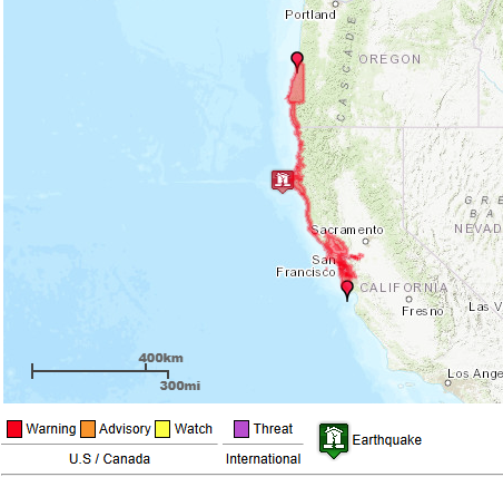
Ok night owls🦉let's talk about the recent tsunami warning🌊We don't get these alerts very often and there are lot of questions, frustration, and even some anger about how it all unfolded. We'll go over the history, science and warning process👇
How common are tsunami warnings in California? There are several types of tsunami alerts, and warnings are the most critical. 

Our last Tsunami Advisory was for the 2022 Tonga Eruption. Our last Tsunami Warning was way back in 2011 for the Tohoku, Japan M9.1 earthquake (Fukushima event).
There are 2 different ways of getting a tsunami warning depending if the offshore earthquake or other trigger event was distant or local.
Distant tsunamis give scientists time to analyze more data and confirm a large tsunami was generated before issuing a warning. A tsunami watch may be issued in the interim. 

There is much less time with a local tsunami, and the warning must be issued with more uncertainty in order to allow the maximum possible evacuation window. Yesterday's event was this type. Let's revisit the timeline: 

10:44 AM: a preliminary assessment suggests a 7.3 magnitude earthquake occurred 45 miles SW of Eureka (later downgraded to 7.0)
10:49 AM: the National Tsunami Warning Center issued a Tsunami Warning for the CA coast north of Davenport (including the San Francisco Bay)
10:49 AM: the National Tsunami Warning Center issued a Tsunami Warning for the CA coast north of Davenport (including the San Francisco Bay)
5 minutes between the earthquake and warning. The NTWC is staffed 24/7, always ready to react this quickly to a new tsunami threat. When it happens this close to the coast, time is critical to enable evacuations as tsunami waves travel very fast (up to 500 mph in the deep ocean) 

The downside of this speed requirement is that the NTWC does not have the luxury of waiting to actually observe a tsunami wave before the first warning is needed. They can only confirm that with deep ocean buoys and coastal observations. 

After the first warning was issued, the scientists at the NTWC continually analyze the latest data on the faulting mechanism and strength of the earthquake, as well as measurements, signs, and/or reports of any tsunami waves. 

In this case, all incoming data after the earthquake pointed to no damaging tsunami threat. The warning was ultimately cancelled at 11:54 AM. 70 minutes after is was issued.
👩🔬Let's talk about the science. What can cause a tsunami?
While approximately 80% of tsunamis are generated by offshore earthquakes, they can also be triggered by underwater landslides, volcanic eruptions, and from meteorological origin. 

Ok, but why do some strong earthquakes generate tsunamis while others don't?
Tsunamis are caused by a large and sudden displacement of the ocean. While all earthquakes shake the ocean, that doesn't cause a tsunami. We need the water column to rise or fall rapidly. 


The most common way for this to happen is during an earthquake along a subduction zone when the ocean floor rises or drops. Transform fault earthquakes are much less likely to generate a tsunami (but still possible with steep bathymetry or landslides) 

The strength, depth, and duration of the earthquake are also important. Typically a 7.0 is needed for a damaging local tsunami, and an 8.0 (10x stronger) is needed for a damaging distant tsunami.
These are just rough guidelines. Other factors (earthquake depth, duration, orientation, accompanying landslides) also play a role. 

Yesterday's earthquake was significant, but occurred on a transform fault and only generated a small tsunami.
It's important to know the risks. A tsunami can happen any time and there's a chance that a near shore tsunami beats the first warning. If you're on the coast and feel an earthquake, get to higher ground immediately. Don't wait for a warning.
If a warning goes out and evacuations are ordered, heed the instructions. Do not enter an evacuation zone to try and see the tsunami. This water travels much faster than you can run. 

We were fortunate yesterday, but don't assume the next warning will play out the same way.
If you evacuated, you did the right thing. Tsunamis are rare, but can be extremely deadly. For perspective, roughly 230,000 people lost their lives in the 2004 Indian Ocean Tsunami, the deadliest natural disaster of the 21st century.
We understand the confusion and disruption this warning caused. Hopefully this thread helped clear up the warning process and rationale. The National Weather Service strives to reduce false alarms while protecting life and property.
You can learn more about tsunamis here:
Let us know if you still have questions about yesterday's event.tsunami.gov
Let us know if you still have questions about yesterday's event.tsunami.gov
• • •
Missing some Tweet in this thread? You can try to
force a refresh


