Aigle Profile picture
Aug 27 • 9 tweets • 7 min read • Read on X
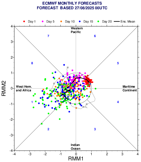
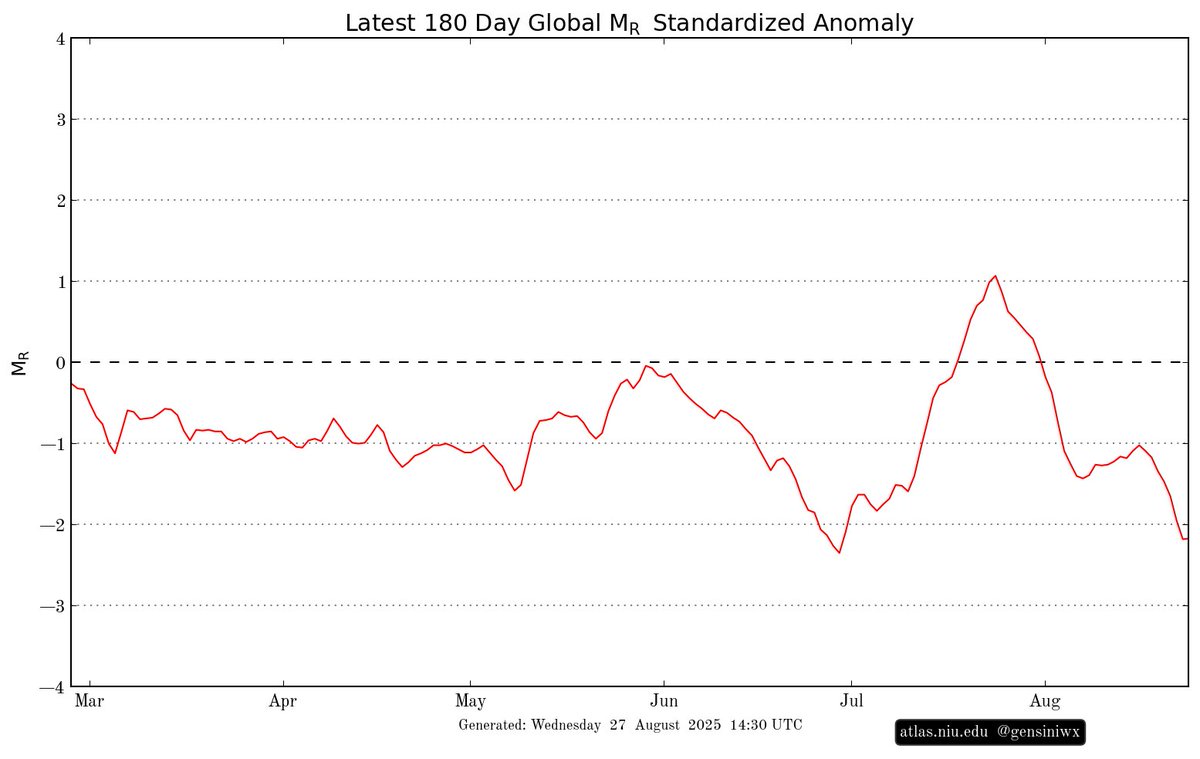
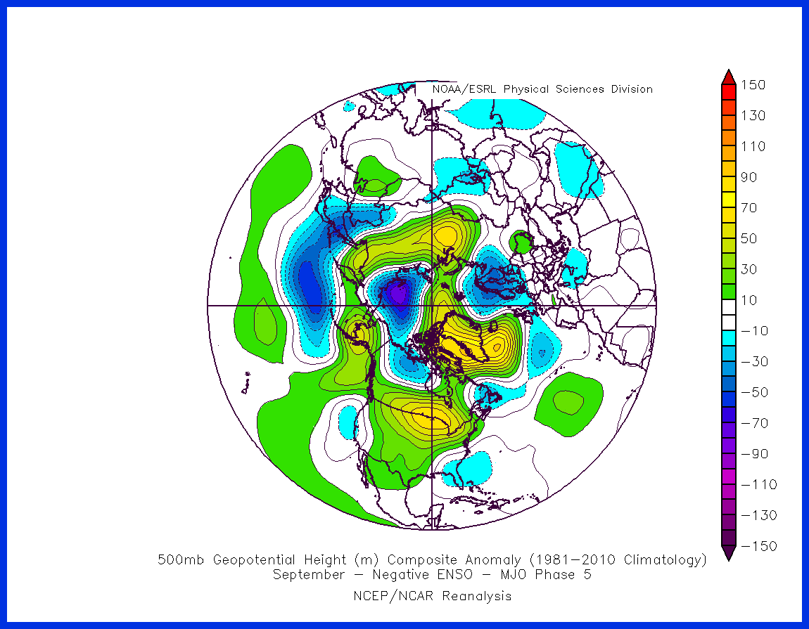
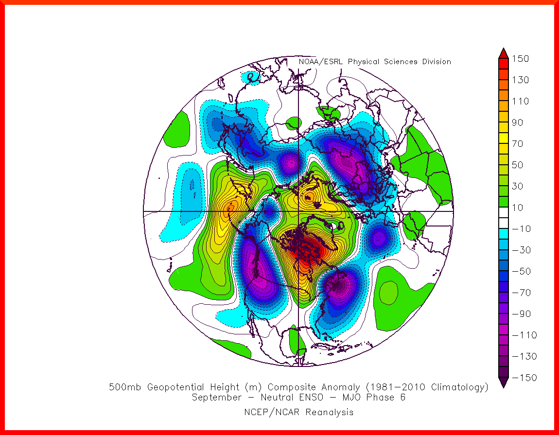
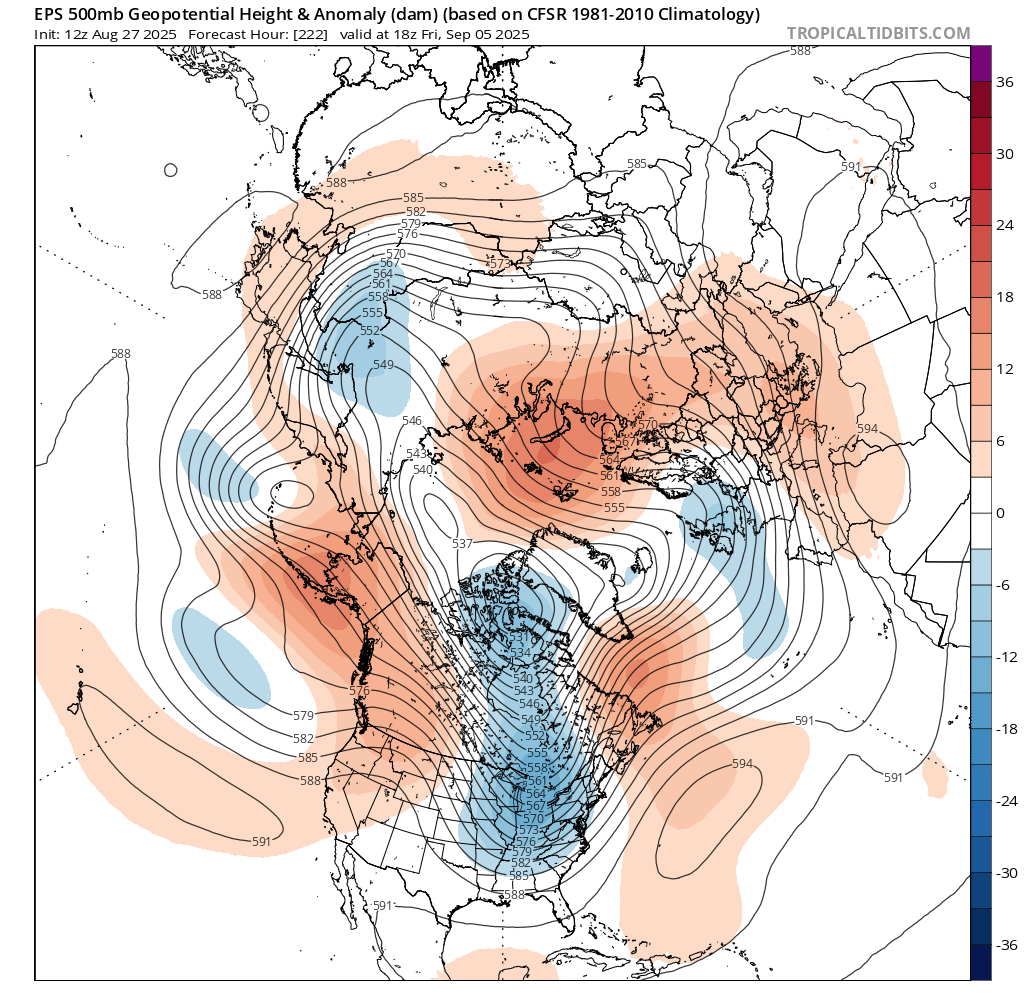
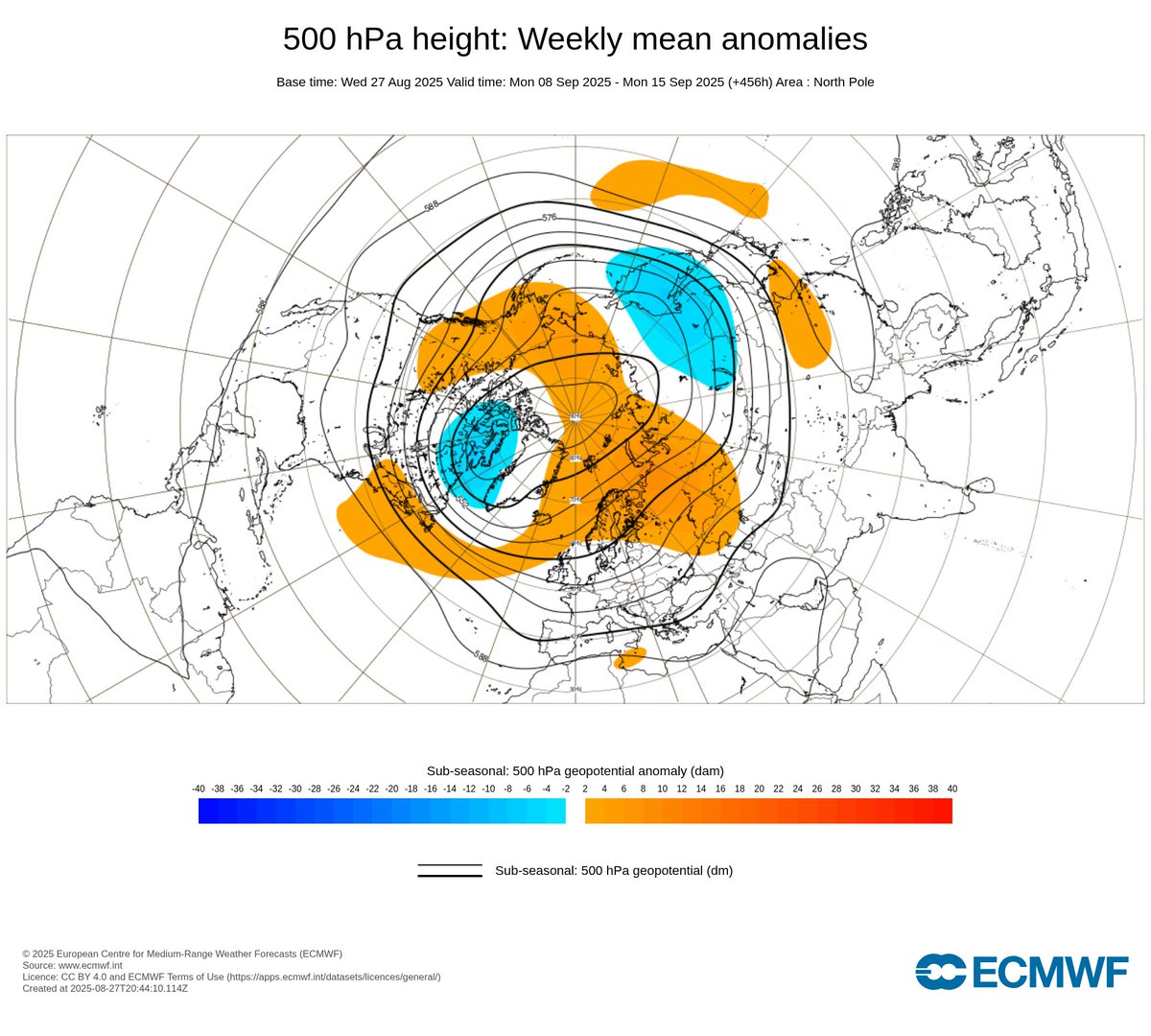
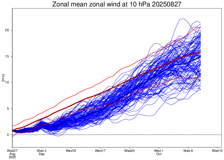
🔧Record weak #SPV, weak MJO propagation, deeply negative AAM & emergent La Niña will be the main subseasonal drivers of the upcoming month, prompting wet conditions across Europe & near-normal temperatures throughout September. 🧵 Image
Image
Image
Image
📉🌧️It is now well-acknowledged that the coming month will likely be thermally near-normal to below-normal across Europe & wetter than average, especially in the first half of the month, thanks to an active rail of low pressure transiting throughout the continent (+NAO/SCAND) ⤵️ Image
Image
Image
Image
Without any sign of strong heat ahead, September could be a relatively "normal" month, climatologically speaking, without this preventing the occurrence of milder epiphenomena. Behind this dynamic, a deeply negative AAM & weak MJO activity works to maintain disturbed conditions⤵️ Image
Image
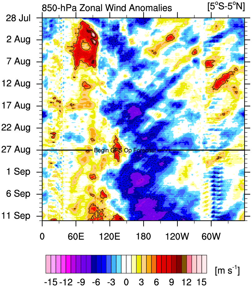
🌊A transition into a very weak MJO phase 6-7 and a rapid return to phase 1 under Niña-like AAM is very likely to contribute to the upcoming unstable pattern, maintaining Greenland-Scandinavian High Lat. blocks, as currently shown in extended-range forecasts ⤵️ Image
Image
Image
Image
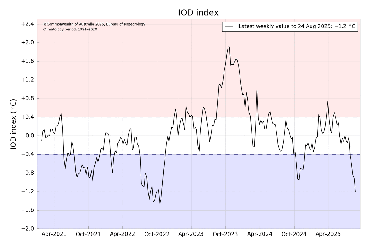
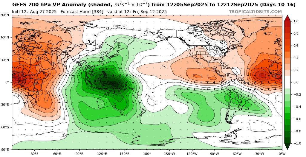
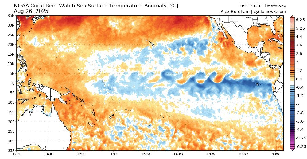
📉 Deeply La Niña-like negative AAM seems to be mainly fueled by a strong negative IOD event underway, sticking convection over the Maritime Continent, strengthening La Niña and in turn contributing to making the AAM negative through a prolonged action-reaction cycle. ⤵️ Image
Image
Image
Image
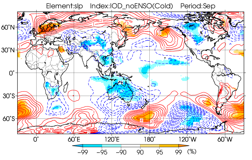
❓ Such conditions is very likely to continue throughout September, making a generally wet & standard or cool September very likely in Europe. JMA composite for -IOD in September match very well with what is currently forecasted in NWP. ⤵️ Image
Image
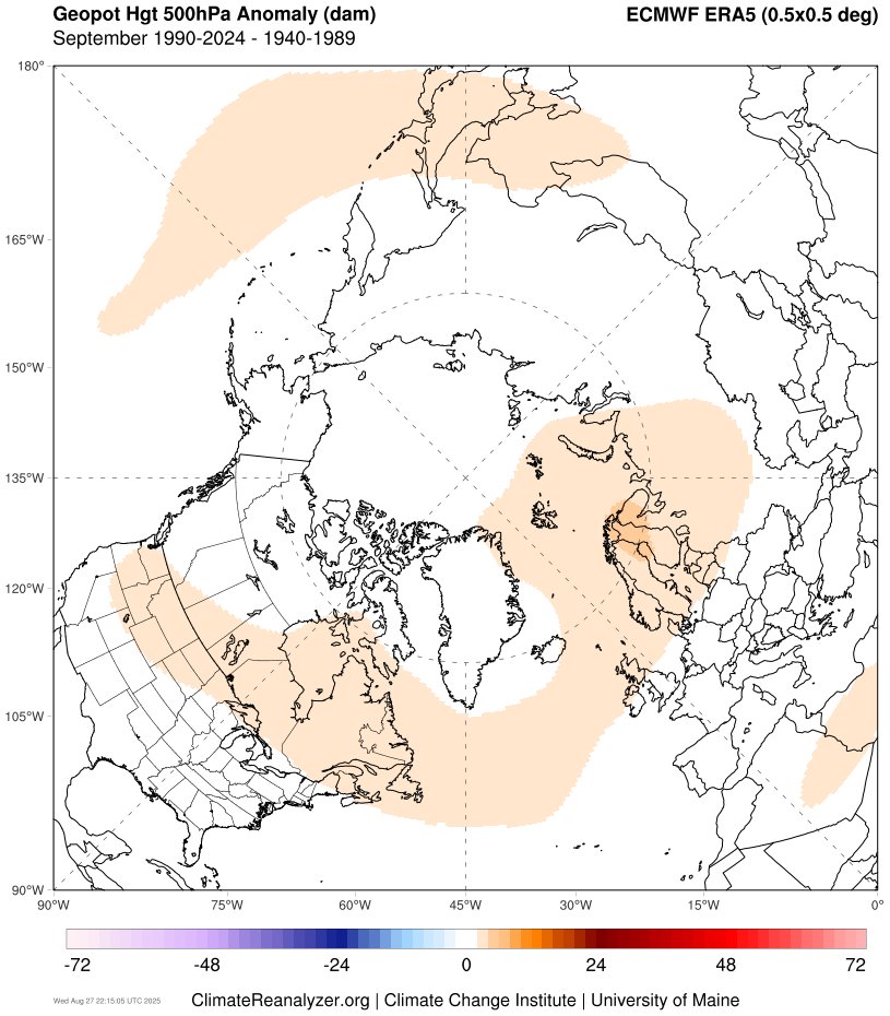
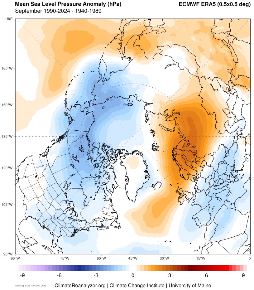
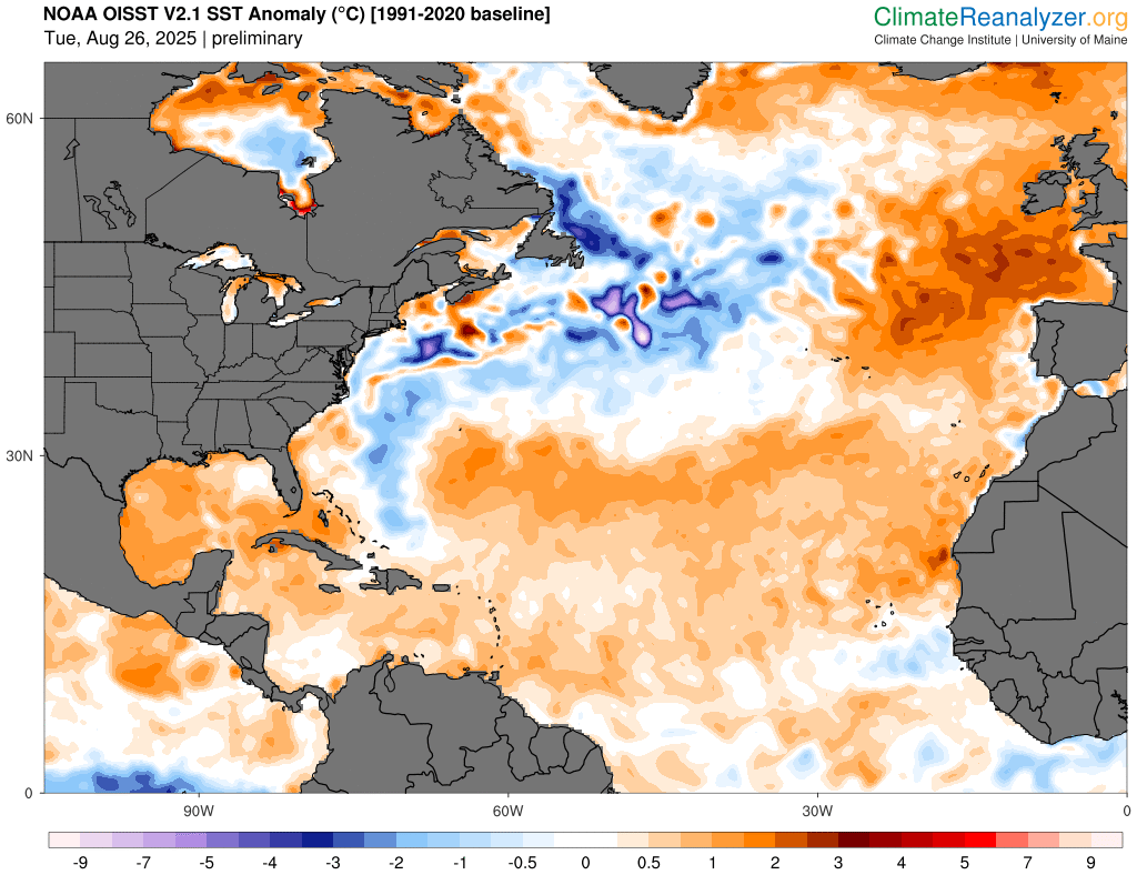
⚒️ These conditions are also close to the trend observed in the past three decades, compared to the period 1940-1989, which was more zonal & likely enhanced by a combination of both record weak #SPV & cooler Atlantic SST pattern prompting such a synoptic. ⤵️ Image
Image
Image
Image
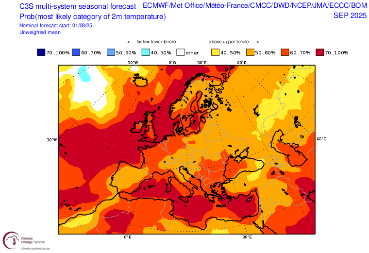
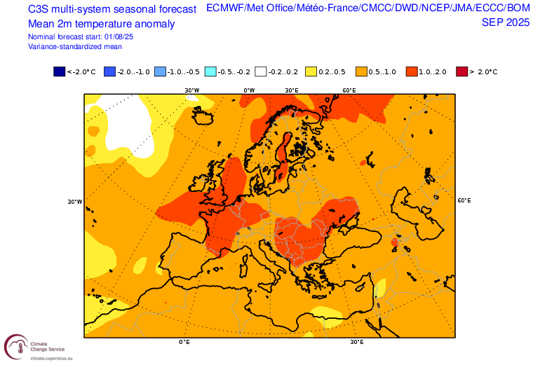
🍂 Overall, I would expect a continuation of disturbed & cool conditions in 🇪🇺 over the next few weeks, w/o excluding the possibility of a possibly significant mild spell, given the persistent strong background warming. A near-normal September would be a blow to the C3S forecast. Image
Image
@threadreaderapp unroll

• • •

Missing some Tweet in this thread? You can try to force a refresh
 

Keep Current with Aigle

Aigle Profile picture

Stay in touch and get notified when new unrolls are available from this author!

Read all threads

This Thread may be Removed Anytime!

PDF

Twitter may remove this content at anytime! Save it as PDF for later use!

Try unrolling a thread yourself!

how to unroll video
  1. Follow @ThreadReaderApp to mention us!

  2. From a Twitter thread mention us with a keyword "unroll"
@threadreaderapp unroll

Practice here first or read more on our help page!

More from @Aigle_e

Aug 16
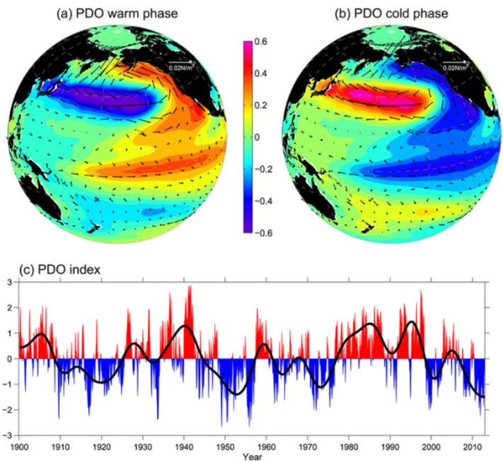
1/ THREAD | LA PDO EST-ELLE UNE OSCILLATION « ARTIFICIELLE » ?

Longtemps considéré comme une oscillation naturelle, la PDO, connu pour ses impacts climatiques mondiaux, pourrait en réalité être influencé par les activités humaines.

DÉCRYPTAGE 🧵 Image
2/ QU’EST-CE QUE LA “PDO” ?

La PDO a été découverte en 1996 par Steven R. Hare dans sa thèse de doctorat portant sur l’étude de l’évolution des stocks de saumon dans le Pacifique Nord, avant d’être formalisée en 1997 dans une étude publiée par Steven & ses collègues⤵️ Image
Acronyme de “Pacific Decadal Oscillation”, la PDO est une oscillation multidécennale des températures océaniques du Pacifique N, alternant historiquement entre une phase négative & positive tous les 20-30 ans adoptant une structure en « fer à cheval », à l’image de l’Atl. Nord⤵️ Image
Read 49 tweets
Aug 7
🌡️Après la plus longue période au-dessus de 1.5°C [par rapport à l'ère préindustrielle] jamais enregistrée, les anomalies de températures mondiales ont chutées ces 3 derniers mois pour retourner aux niveaux de réchauffement proche des conditions post-Nino 2023-2024. Image
@CopernicusECMWF 📌 En juillet 2025, la température mondiale était supérieure de 1,25°C à la moyenne estimée entre 1850-1900. Ce n'était que le quatrième mois sur les 25 derniers mois où la température mondiale était inférieure de 1,5 °C au-dessus du niveau préindustriel. Image
@CopernicusECMWF 📌Cela ne signifie pas que le réchauffement climatique s'est arrêté. « Si nous ne stabilisons pas rapidement les concentrations de GES dans l’atmosphère, nous devons nous attendre non seulement à de nouveaux records de température, mais aussi à une aggravation de ces impacts » Image
Read 19 tweets
Aug 1
ℹ️La chaleur est désormais confirmée. Quelles sont les causes de ce changement de régime? 1/ L'AAM a entamé sa chute, générant une modification des flux atmosphériques, 2/ la MJO passe en phase 8-1, 3/ en conséquence, la NAO va redevenir positive. Décryptons cela dans ce thread⤵️ Image
Image
Image
Image
1/ l'AAM, indicateur du moment atmosphérique terrestre, a entamé sa chute, faisant suite à une forte hausse depuis mi-juillet. Cela a commencé à redistribuer les vents zonaux dans l'HN, propageant vers le sud les anomalies - & +, signature d'un retour imminent de la NAO+ Image
Image
C'est la deuxième fois de l'été que cela se produit, après la chute de fin Juin ayant provoqué une poussée de NAO+ durant la 1ere décade de Juillet. La tendance négative est associée à une propagation vers le sud des anomalies, alors qu'une tendance positive produit l'inverse
Read 15 tweets
Oct 10, 2024
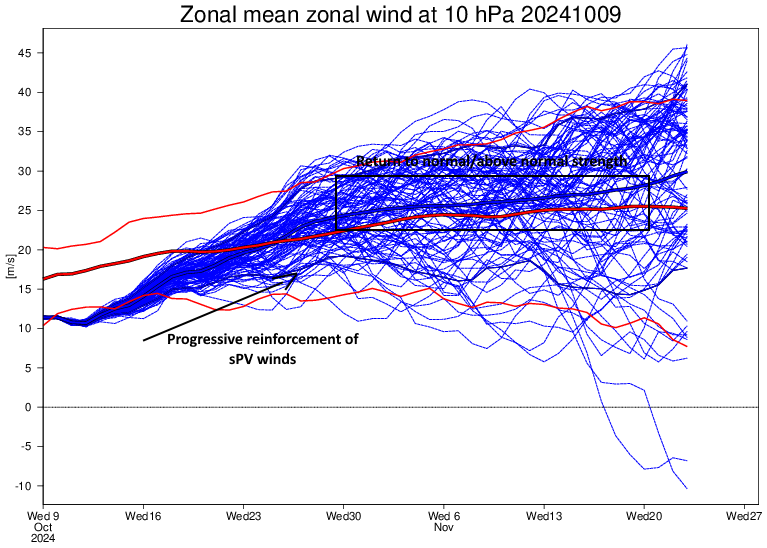
In the next few days, a +NAO/+SCAND atmospheric pattern will establish over Euro-Atlantic region, breaking >2 weeks-long strong -NAO episode, in response to current MJO phase 3 over Indian Ocean & moving into phases 4-5 next week, strengthening of sPV & rise of AAM. đź§µ1/9 Image
Image
Image
Image
Since early Oct & throughout Sept, -NAO was v. predominant, associated w/ record weak sPV lead by ozone-induced warming, +WP/+PNA & WPAC MJO influence. As MJO started to move into IO, sPV strengthen & +PNA/+WP weaken, 2nd part of October expected to break w/ last weeks scheme 2/9 Image
Image
Image
Image
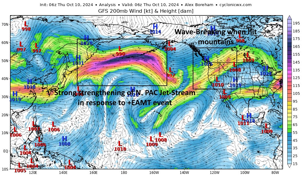
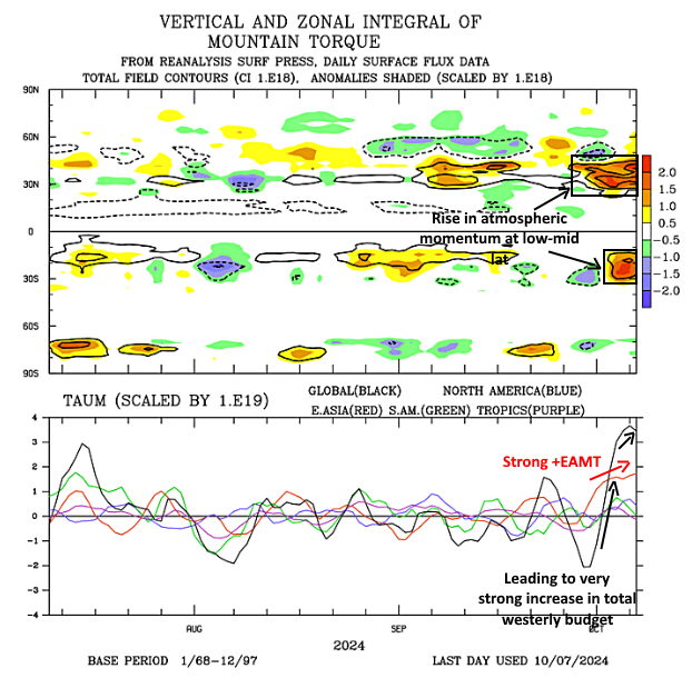
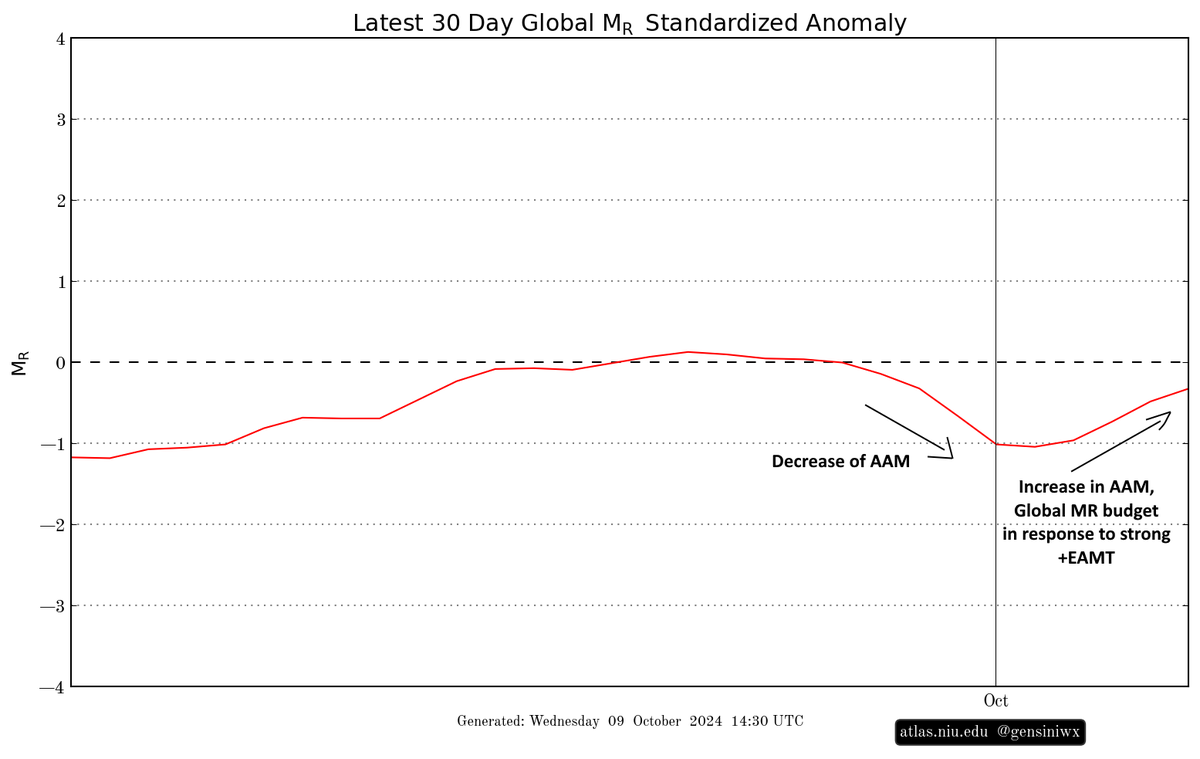
In addition, a strong +EAMT event has occurred, leading to a strong strengthening of the Pacific Jet & to an ↗️ in the AAM resulting in an strengthening of westerly winds in total budget & ↗️ total momentum at lower-mid latitudes, increasing jet wave-breaking probability. 3/9 Image
Image
Image
Image
Read 10 tweets
Aug 21, 2024
Un article au titre trompeur & au contenu imprécis de @courrierinter diffusé hier faisant mention d'un "refroidissement record" de l'océan Atlantique a été massivement relayé dans les sphères climatosceptiques. Multipliant les inexactitudes, il n'est toujours pas rétracté 1/14 Article trompeur de Courrier International massivement relayé dans les sphères climatosceptiques et amplifié par des médias tiers.
@courrierinter @verif_TF1LCI @AfpFactuel @SergeZaka @FloC36 @QuotaClimat @AFPFactCheck @AiRicK63 @NiceJungle06 @SkyPhilippe S'appuyant sur une note de blog de la NOAA et multipliant les déclarations contradictoires mêlées à un contexte insuffisant et à d'importantes inexactitudes, l'article de @courrierinter apparaît confus et contribue à alimenter le discours climatosceptique 2/14


Image
Image
Image
Image
@courrierinter @verif_TF1LCI @AfpFactuel @SergeZaka @FloC36 @QuotaClimat @AFPFactCheck @AiRicK63 @NiceJungle06 @SkyPhilippe Repris par d'autres médias comme @RTBF, @Slatefr ou encore @GEOfr, réitérant les mêmes inexactitudes que l'article cité, la portée médiatique de cette information erronée dépasse le seul public du journal, qui porte une responsabilité particulière dans sa diffusion 3/14 Image
Read 16 tweets
May 1, 2024
[RISQUE ORAGEUX DU MERCREDI 01/05/2024]

Une dégradation orageuse virulente est attendue sur l'Île-De-France, le Nord-Est du Centre et l'ouest de la Bourgogne-Franche-Compté dès ce soir, pouvant s'accompagner de phénomènes localement violents 🧵/18 Image
tels qu'une densité de foudroiement élevée, de fortes précipitations, un risque de grêle de taille parfois conséquente localement (~5cm), et de phénomènes tourbillonnaires localisés. (🧵2/18)
Bien que très difficile à prévoir, la possibilité de phénomènes tourbillonnaires apparaît accrue par la formation d'une dépression de mésoéchelle en surface au contact d'une advection très chaude de Theta-E et l'air plus frais à l'ouest. (🧵3/18)
Read 17 tweets

Did Thread Reader help you today?

Support us! We are indie developers!


This site is made by just two indie developers on a laptop doing marketing, support and development! Read more about the story.

Become a Premium Member ($3/month or $30/year) and get exclusive features!

Become Premium

Don't want to be a Premium member but still want to support us?

Make a small donation by buying us coffee ($5) or help with server cost ($10)

Donate via Paypal

Or Donate anonymously using crypto!

Ethereum

0xfe58350B80634f60Fa6Dc149a72b4DFbc17D341E copy

Bitcoin

3ATGMxNzCUFzxpMCHL5sWSt4DVtS8UqXpi copy

Thank you for your support!

Follow Us!

:(