LiorLefineder Profile picture
Dec 5 5 tweets 2 min read Read on X
Technological innovation has largely been driven by a small elite.
"drawing on patent records linked to census data. We document that the rise of innovation during Sweden’s industrialization can largely be attributed to a small industrial elite belonging to the upper-tail of the economic, educational, and social status distribution."Image
Half of all Swedish inventors came from a highly elite background, and another third from the upper middle class. Image
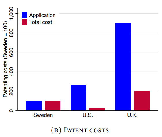
Interestingly, Britain, where the Industrial Revolution first occurred, had a relatively less efficient and more expensive patenting system compared to other Western countries. Image
Many important inventors around the time of the British industrial revolution received nothing for their work
Inventors among the “Impoverished Sophisticate”
cambridge.org/core/journals/…

• • •

Missing some Tweet in this thread? You can try to force a refresh

 

Keep Current with LiorLefineder

LiorLefineder Profile picture

Stay in touch and get notified when new unrolls are available from this author!

Read all threads

This Thread may be Removed Anytime!

PDF

Twitter may remove this content at anytime! Save it as PDF for later use!

Try unrolling a thread yourself!

how to unroll video
  1. Follow @ThreadReaderApp to mention us!

  2. From a Twitter thread mention us with a keyword "unroll"
@threadreaderapp unroll

Practice here first or read more on our help page!

More from @lefineder

Dec 2
2% of Hungarians have surnames ending in "y"; they were adopted in pre-modern times by elite families, signifying their origin. These "..y" surnames are still highly overrepresented among Hungarian elites.

"29% of all Hungarian prime ministers since 1848 came from a ...y named family", 43% of Austro-Hungarian PMs, and one French President whose father belonged to the lesser Hungarian nobility, Nicolas Sarkozy. Also, two of the ten Hungarian Nobel-laureates had a ..y surname.Image
This study tracking elite surnames among skilled professionals and academics in Hungary shows that "social mobility rates under communism were the same as in the subsequent capitalist regime." Image
"High-status names are much more over-represented in science than they are in politics, and this does not even change during the worst years of Stalinist dictatorship."
Read 5 tweets
Nov 28
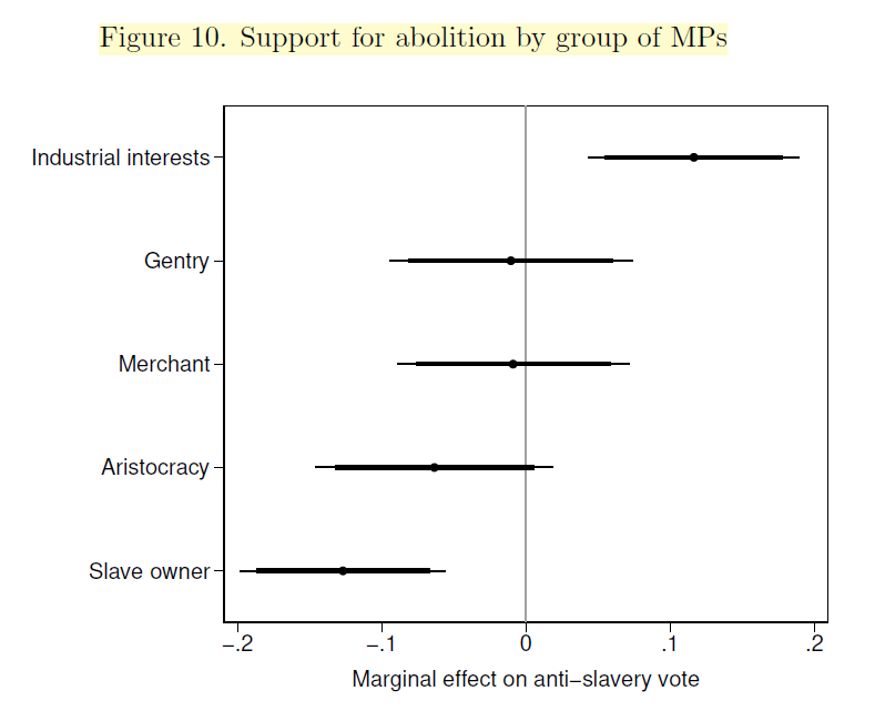
The abolition of slavery was advanced by Capitalists and industrialization.

British MPs who were industrialists or were sons of industrialists were the most supportive of anti-slavery bills. For other elites, there was "no correlation between attitudes towards abolition and being a merchant, a member of the landed elite or aristocracy, or having attended Oxford or Cambridge."Image
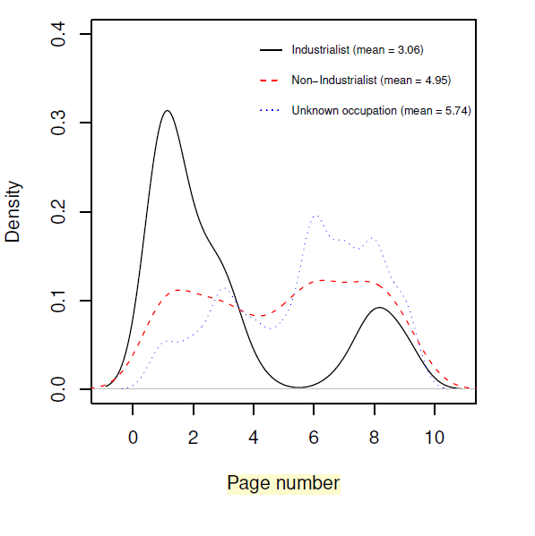
The most common occupation of the signers on the 1806 Manchester anti-slavery petition, one of our earliest surviving anti-slavery petitions, was related to manufacturing. Image
And signatures of industrialists were more likely to be at the forefront of the petition, on the first pages. Image
Read 8 tweets
Nov 6
The grand destruction of sedentary steppe areas of Eurasia by the invention of cavalry and the coming of Scythian-Cimmerians.🧵
"In the steppes of the North Black Sea and Azov Sea, as in the other steppe areas of Eurasia, the Iron Age corresponded with the transition of the Eastern European inhabitants from sedentary, pastoral agrarian people to nomadic, animal breeding tribes. By the 9th century B.C. the numerous steppe settlements including surface and subterranean dwellings used by the Bronze Age population had disappeared."Image
Scythians would later ravage the Near East
"Scythians ruled Asia for 28 years and devastated everything through their violence and overindulgence. They laid everybody under tribute but as if that were not enough they raided and robbed everything each people had" - Herodotus Image
Only in the late 5th to 4th century BC sedentarism returned to the steppe.
"From the 9th century B.C. to the late 5th century B.C. the tribes constantly moved their herds from one pasture to another. In the late 5th century B.C. and following into the 4th century B.C. the nomads began to settle in areas"
Read 9 tweets
Oct 13
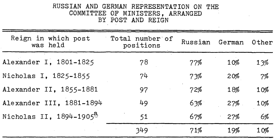
Germans accounted for 19% of the ministers in the Russian Empire, despite being around 1% of the empire's population.

Most of these Germans were 'Baltic Germans' incorporated into the empire during the conquests of the Great Northern War (1720). Only 80 years later, we already see that Germans have risen into positions of high prominence in the Committee of Ministers of Alexander I.Image
Detailed origin of ministers.
The other non-foreign non-Baltic German ministers are probably Volga Germans brought in by Catherine the Great.
"The six ministers of German descent were either two or three generations removed from their families' immigration to the Russian Empire." Image
"If Russian nationalists impugned the loyalty of the German bureaucrats, the tsars themselves never did so, always stressing the faithfulness of their high German servants. 'The Russian Nobles serve the State, the German ones serve us,' declared Nicholas I." Image
Read 5 tweets
Oct 7
Linear B tablets mention Women taken as war captives from Anatolia, showing Mycenaean Greeks were raiding the region of Troy.
"These descriptions often use the word lawiaiai, ‘captives’, which is the same word used by Homer to describe women seized by Achilles."

Note that the Iliad begins with Achilles' rage about Agamemnon not handing him a captive woman (Briseis).Image
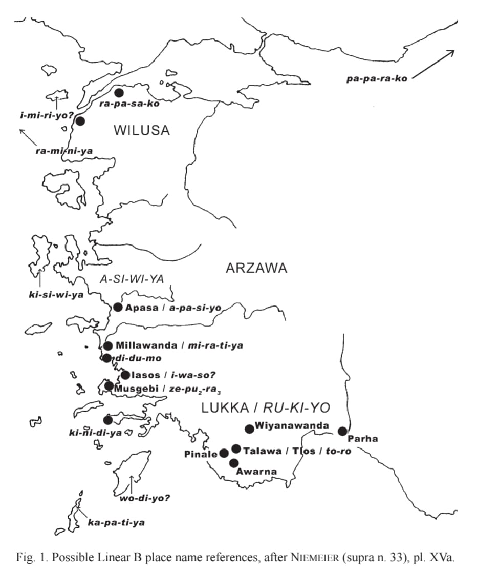
The Mycenaeans were very familiar with the coasts of West Asia, and many places there are referenced in Linear B tablets. Image
Text in the top tweet from: Image
Read 4 tweets
Oct 1
Greco-Roman writers were the first to use coordinates of latitude and longitude to map places, and the first to lay down geometrical treaties specifying how to project regions onto maps.
This transformed Geography from a mere itinerary, schematically displaying places, into a real science based on mathematical principles.

Ptolemy's Geography, written around 150 AD, gives the coordinates of 8,000 different places, on top of being a monumental achievement in pre-modern mapping, when these coordinates are compared to modern Greenwich coordinates, a tight correlation is seen (0.98) between the numbers, indicating a remarkable degree of accuracy.Image
Image
Comparison of Ptolemy’s longitudes and latitudes with real values.
ancientportsantiques.com/ancientmaps/cl…Image
This map displays the degree of deviation between Ptolemy's coordinates to the actual position of locations.
We can see that the furthest places from the centers of the Roman world are mapped less accurately. Image
Read 10 tweets

Did Thread Reader help you today?

Support us! We are indie developers!


This site is made by just two indie developers on a laptop doing marketing, support and development! Read more about the story.

Become a Premium Member ($3/month or $30/year) and get exclusive features!

Become Premium

Don't want to be a Premium member but still want to support us?

Make a small donation by buying us coffee ($5) or help with server cost ($10)

Donate via Paypal

Or Donate anonymously using crypto!

Ethereum

0xfe58350B80634f60Fa6Dc149a72b4DFbc17D341E copy

Bitcoin

3ATGMxNzCUFzxpMCHL5sWSt4DVtS8UqXpi copy

Thank you for your support!

Follow Us!

:(