
Seven years ago, in the early hours of the 28th of June, Blackpool Village was inundated with floodwater from the River Bride. This video filmed at 5:11AM (according to camera data) was made available via AIE request to OPW. It looks as if a dam had collapsed upstream. #cork
It is interesting to see how the matted vegetation on the fence is acting as a very effective water barrier at 1:10 in the clip.
Apologies for sound. Blame twitter.
Just to clarify. This clip was filmed on the morning of the 28th of June 2012. (According to camera data)
Ten years previously in November 2002, Blackpool Village flooded twice in the space of a week. The army subsequently removed a large amount of debris from the culvert at Blackpool Bridge. Picture (cropped from the original) received, via FOI request, from Cork City Council. #cork 

Inadequate culvert culvert capacity and blockage were presented as the cause of flooding at a Cork City Council meeting held a few weeks later on the 10th of December 2002.

Excerpt from Dáil Éireann debate on the 21st of November 2002 - after Blackpool Village was flooded earlier that morning. The statement was made by Micheál Martin in response to Dan Boyle. Blackpool was to flood again just days later. @MichealMartinTD @sendboyle #cork

Kathleen Lynch raised the issue of development on floodplains in the Dáil a week later on the 27th of November 2002. More development was to follow...@KathleenLynch05 #cork

Here are some excellent pictures of the Polefield/Tucker's Field in 1998. It shows the River Bride diverted to accommodate the Blackpool bypass and phase 1 of the Orchard Court development in progess. Many thanks to Kevin Dwyer who gave me permission to use his pictures. #cork


Note the Sunbeam Factory at the top of the first picture. A huge local employer in it’s heyday. Now long gone.
I've spent many hours over the last few years trying to find out why Blackpool needs a flood scheme. After quite a few information requests to the OPW and CCC and my own research I thought it would be useful to put what I have learned into a single chronological thread. #cork

OPW - Office of Public Works
CCC - Cork City Council
CCC - Cork City Council
For clarity, here are those two pictures of the Polefield and Tucker's field with the River Bride main channel (as it stood at the time) marked out as accurately as possible. I have confirmed this using planning drawings. #cork


The first picture looks North toward the Sunbeam Factory taken from over Blackpool Village. The second looks South toward the North Ring Road taken from over the Sunbeam factory. (approximate positions) #cork
I can't accurately show changes made to the river (before pic was taken) to facilitate the Blackpool Bypass as I'm not 100% clear on it. Based on comparisons between old maps and a 1995 aerial photo I'm reasonably confident that the changes took place within the red circled area.

The centre of the red circled area in the previous tweet is approximately 500m upstream of Blackpool Village. Measured via google maps.
Development/construction between 1997 and 2002 in the vicinity of the Polefield/Tucker’s Field include:
Blackpool Shopping Centre
Blackpool (N20) Bypass
Orchard Court Housing Estate (Phase 1)
Blackpool Shopping Centre
Blackpool (N20) Bypass
Orchard Court Housing Estate (Phase 1)
Lots of hard impermeable surface area introduced into an area that previously would have soaked up a lot of rainwater. Where was the rainwater going after this? Planning documents shows much of the surface water run-off directed into the river. How much? Who knows.
While changes were being made to the river in the vicinity of the Polefield and Tucker's field in the late 1990s - downstream the culvert system leaving Blackpool village was built in the 1800s. An arched masonry design, part of it would later collapse.
Here is a picture of what that stretch of culvert might have looked like before it was replaced (between the church and Maddens buildings) around 2003/2004 (this picture is of the existing 1800s culvert still in use under Watercourse Road downstream of Maddens Buildings). #cork

To be clear, according to documents I have seen, the collapse I refer to here occurred in the culvert under Blackpool Bridge in around 2003.
If those following this thread spot any details I may have got wrong - please say so. I have been very careful in my research but mistakes happen. I have used old engineering reports, maps, planning documents and aerial photography to get this story together.
A quick look at map.geohive.ie and comparing the 1995 aerial photograph with the 2000 will reveal the extent of development in those 5 years from the Northpoint business park all the way down to Blackpool Village. It was a very busy time...celtic tiger and all. #cork
A significant diversion was made to the Bride River in the late nineties upstream of Fitz's Boreen introducing two right angles into river course. I'm no hydraulic engineer but I'm reasonably certain that rivers don't do right angles so well. Moving on...
This bridge was located where the vehicle entrance bridge to the Orchard Court estate now spans the River Bride - 80m upstream of Blackpool Bridge culvert entrance. It was a twin arch stone bridge similar in style to the one currently located at Fitz's Boreen. Replaced circa 1999

Still here? For those who you who have managed to stay awake while wading through this thread we move onto trash screens, but first let's take a brief look at Section 50 of the Arterial Drainage Act, 1945 - irishstatutebook.ie/eli/1945/act/3…

'The Office of Public Works is responsible for the implementation of the regulations in the Arterial Drainage Act, 1945, including Section 50' - opw.ie/en/media/20190…
So Section 50 is there to ensure that new bridges and culverts and alterations to existing bridges and culverts do not contribute to flood risk. Let's move on to those trash screens.
Between December 2002 and January 2003 three trash screens were placed in the River Bride upstream of Blackpool Village - presumably to prevent debris from washing into the culvert system and causing a blockage and flooding as had appeared to have happened twice in November 2002
This one was installed at the Orchard Court pedestrian bridge approx 20m upstream of the Blackpool Bridge culvert opening. It appears to have been replaced/modified at least three times since it was installed due to damage. It was removed for good in 2014. Picture from AIE to CCC

This screen was installed at the the Orchard Court vehicle bridge. According to an engineering report, removed in 2012 due to scouring of river bank. Pics from AIE to CCC show it in various states of damage. It was located 100m upstream of Blackpool Bridge culvert opening. #cork

This screen was located at Brothers Delaney Rd culvert, approx 430m upstream of Blackpool Bridge culvert opening. It was the largest of the three screens - the height from the culvert floor to the supporting brackets near the top of screen was approx 2.3m. It was removed in 2014.
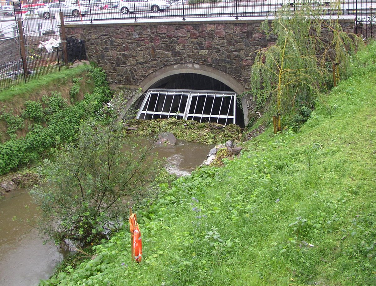
Camera data suggests that the pictures of the screens in the last three tweets were taken in and around 2005. Probably on the same day. I am not 100% on the year but reasonably sure.
I requested copies of Section 50 consent for these 3 trash screens in email correspondence with the OPW (issuing body for section 50 consent) late last year - they can't be located. In response to an AIE request to Cork City Council for the documents, I was told they do not exist
It's clear from the pictures received from that AIE that all three trash screens were subject to blockage from vegetation washed downstream. All three screens were ultimately removed years later. Here's the screen at the Brother's Delaney Rd culvert in Nov 2009 - my own picture.

Last year I submitted a list of 17 structures to OPW that are/were installed along the River Bride from late 1990s (to date) including the culvert section installed under Watercourse Rd 2003/2004 after 2002 flooding. They cannot locate Section 50 consent for any of the 17...(1/2)
According to OPW section 50 documentation for these structures may exist, they just cannot be located after a thorough search. Some documentation and plans were forwarded to me relating to the Brothers Delaney Rd and Blackpool bypass culvert. 2/2
In fairness to the Office of Public works I asked for a lot of stuff over the last few years, and the responses were always prompt and detailed. I can’t complain about the communication side of things really (after the exhibition of the Blackpool FRS in Nov/Dec 2015).
My own suspicion is that Section 50s don't exist for most of these structures and probably never have. I'm not an engineer but even I wouldn't have signed off on many of them. More about the trash screens later.
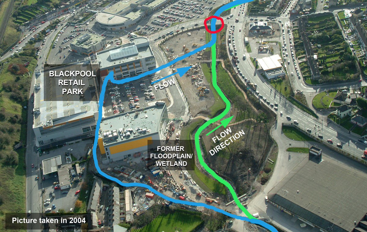
In early 2003 permission was sought to further divert the River Bride approx 600m upstream of Blackpool Village in order to facilitate development on the Polefield. The village had flooded twice in the space of a week just two months previously. #cork
Planning documents show that there were a number of objections to this proposal at the time. People in Blackpool Village were still dealing with the fallout of the November 2002 flooding. Part of the culvert under Blackpool bridge had collapsed into the river...#cork

Assurances were given - a flood memorandum detailed how the proposed amenity park would be designed to create 'a large flood lake above the Brothers Delaney culvert' - a culvert located at the Southern end of the site conveying the River Bride as it flowed out of the park. #cork

Here is a diagram showing the proposed flood lake during a flood event - looking from the North towards the Southern end of the park where it flows out of the park via the Brothers Delaney culvert - circled in red by myself. #cork

According to planning conditions - the culvert circled red in my previous tweet was to have restricted flows.

Permission was granted in June 2003 and the Bride was rerouted to facilitate the development in August 2003. Picture (looking South) shows the river channel before 2003 diversion in blue and after in green (approximate). The Red ring shows Brothers Delaney culvert. Pic taken2004
Here’s the river route you asked me about a few tweets ago @KarlDiskin
In this excerpt from a planning document dated Sep 2003, the Polefield is described as having been 'very low-lying and marshy and is the flood plain of the River Bride.' It also details how 'the ground was significantly raised to prevent further inundation by the River Bride'.

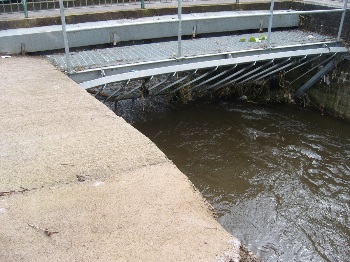
Picture (pic via AIE) shows trash screen located at the Brothers Delaney culvert around 2005. According to planning conditions a restriction was to be located here to protect Blackpool Village against flooding (see earlier tweet). Note high river banks upstream of screen. #cork

Following on from previous tweet. Here is a picture also taken around 2005 (via AIE from CCC) showing the river backing up into the park due to screen blockage. Bear in mind that the top of that screen is approx 2.3m above the river/culvert bed. #cork

Following on from previous tweet - take a look at this picture of the same screen from the OPW report on flooding of Blackpool Village where the culvert system was overwhelmed in the early hours of the 28th of June. Now go back and look at the first tweet in this thread #cork

Following on - it stands to reason that with this screen out of commission - the only remaining screen located approx 400m downstream would have been much more exposed to blockage which appears to have been the case on March 21 2013 when Blackpool Village flooded again. #cork

To sum this thread up - in my completely unqualified (though reasonably well informed)opinion, the Blackpool Flood Relief Scheme is the inevitable result of poor decisions - particularly in relation to drainage and planning in the late 1990’s to the early 2000’s. #cork

It is highly likely that this trash screen collapsed after it became blocked in the early hours of June 28th 2012. It would have suddenly released floodwater that had accumulated in the Blackpool Retail amenity park (designed to store floodwater). A bit like a dam bursting. #cork
Another clip of the flooding of Blackpool Village June 28th 2012. Received via AIE request to OPW. Camera data shows the clip as being filmed at around 5.15am. (I have removed audio as voices may be identifiable). It cost me €160 to access information from the 2012 event. #cork
At the beginning of the clip the water is shown flowing out of Wherland’s lane in the village after the River Bride burst its banks upstream of the Blackpool Bridge culvert. See the very first clip in this thread for context.
Four further video clips of the event were withheld by the OPW citing right to privacy of individuals.
I believe the statement below is important because the section of culvert referred to was partially blocked by a 2 foot bank of debris/sediment - most likely due to river works conducted a few hundred meters upstream a few years before flood events in 2010, 2012 and 2013. #cork


