Hello. Myself, @Yaolri & @iayongwa are monitoring the growing situation in south west Cameroon.
Lots of unverified footage emerging of burnt villages and people dying in the streets. If you see something, DM one of us (our DMs are open and we will communicate through Signal).
This is one of the videos that was released today. It was filmed in Mautu. The bikes you see at the start of the footage were located exactly here on Mautu's main road: goo.gl/maps/CmqUZr4WR…
Just to show what we are doing with the footage - we're starting by investigating each individual scene and mapping them out. We're looking for evidence of who is responsible for this. The scenes here are geolocated to here: goo.gl/maps/CmqUZr4WR… in Mautu, #Cameroon.
Last week Cameroon's #Bali was also hit hard. Many locals allege the Cameroon military is responsible for the burning of the villages. This was one of the videos @iayongwa geolocated which shows the scale of damage.
@iayongwa This is footage also from #Mautu, #Cameroon. Again it is GRAPHIC. The person filming says the attack happened Thursday, 23, and says "they have killed so many people". Footage is geolocated to here: goo.gl/maps/TjsMNN2EU….
@iayongwa In this footage from Cameroon geolocated by @iayongwa, we can also see destroyed buildings on sat imagery around #Bali's main market & health center on @sentinel_hub. I've made a timelapse below of imagery from January 17 & 22. Location is here: goo.gl/maps/ec7eP6ouM…
@iayongwa@sentinel_hub This is #Mautu Village in south west #Cameroon. Residents have fled village turning it into ghost town. It was only several days ago that a number of people were butchered in its main street. The filmer was standing exactly here: goo.gl/maps/rf4CARKm4…. H/T to @FMbanwei for 📹
Path (in red) that the filmer took in the footage above. Buildings used as geo-reference points. Person filming says "all the civilians have fled into the bushes". The reference to people being killed is evidenced in the tweets above. Filmed here: goo.gl/maps/CSVgAkGN2…
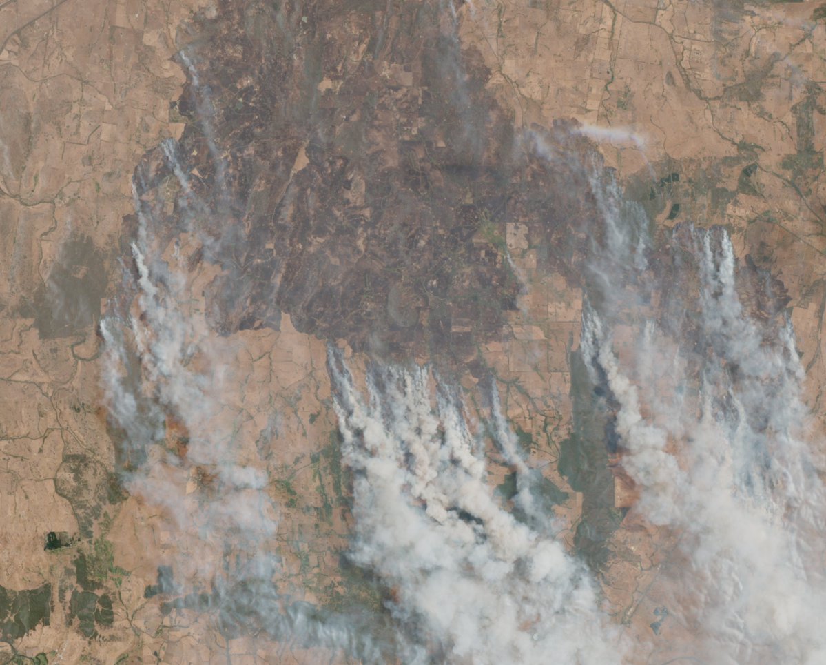
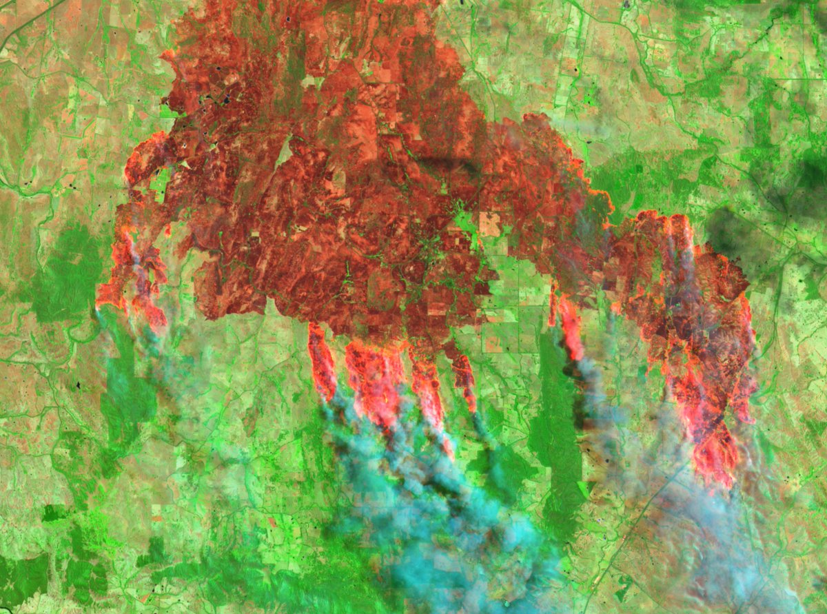
Cameroon municipal elections sched for Feb 9 (H/T to @billyb2009 for reminder). Seeing increase in sporadic attacks, namely village burnings, & in large areas like Kumbo (geolocated by @iayongwa). Very important for #remotesensing atm 👇
Today US DoJ announced seizure of two domains and the search of 968 accounts on X used in a "Russian-government backed campaign" to spread disinformation.
Affidavit includes all of the accounts requested from X 👇
The DoJ announcement said the campaign used elements of AI to create fictitious social media profiles purporting to belong to individuals in the United States, which the operators then used to promote messages in support of Russian government objectives. justice.gov/opa/pr/justice…
The affidavit for the accounts on X shows that all of the accounts were registered to email addresses that were either using the domain 'otanmail' or 'mlrtr' justice.gov/d9/2024-07/aff…
A new coordinated network of fake accounts pretending to be ‘Real Sikhs’ is targeting activists, stoking tensions and promoting Indian Govt narratives.
Who are they, what do they post, and how do they spread their campaign? Report:
Let's take a look 👇🧵 info-res.org/post/return-of…
Before we start, it's important to note that this is not the first time we have exposed a network like this at @Cen4infoRes. In Nov 2021 we identified a similar network. But in the months after the accounts were removed, new accounts popped up.
In this new network, what we do know is the network of fake accounts posts content to undermine Sikh activists, stoke cultural tensions and promote Indian government narratives. But who are the accounts, and how are they posting so that we can catch future attempts?
In April, CNN journalists were led to the 'home' of Haitian gang lord Vitel’homme Innocent and interviewed him. He is on @FBIMostWanted's Top 10, with a bounty of up to $2 million.
I mapped their drive and found his home here: 18.5278, -72.2314. Here's how👇🧵
First, I did this because knowing the location of where a gang lord responsible for horrible violence is helpful, even if he might not be there after CNN visited. Vitel is the leader of Kraze Barye and is on the @FBIMostWanted list for taking hostages, and sanctioned by UN.
This is the footage I used to geolocate Vitel'Homme Innocent's house, where the interview was conducted. I'll go through some of the scenes to provide proofs of how I made the geographical matches, using Google Earth.
Google Earth has updated the whole of Sudan's El Geneina to reveal the disturbing scale of damage which happened during a reported ethnic cleansing campaign over the past year by the RSF and allied militias. Images shows #elgeneina from 2022 & 2024. More in the thread below 👇
Looking at the destruction visible on Google Earth, it's clear there were large areas targeted in El Geneina's west and east. It's worth noting that some of the shaded areas in the east had remainders of where there was previous destruction from clashes prior to 2023.
The destruction can be clearly seen in this area on Google Earth, just west of the centre of Darfur's El Geneina. The comparison is of Oct 2022 and April 2024. This satellite imagery is just a visualisation of the horrors that were committed by the RSF in its campaign.
The situation in the Darfur city El Fasher (الفاشر) is extremely concerning. It's the last city not under control by the dangerous Rapid Support Forces and has been a safe haven for those fleeing attacks by the RSF.
It is now a city under siege and in a grave situation. /1
According to @MSF, a paediatric hospital in El Fasher was damaged due to the ongoing fighting. MSF ground staff reported a Sudanese Armed Forces air strike exploded nearby causing the damage. Two children died in the ICU. /2
An update on Sudan's El Fasher from @MSF on May 15 indicated that since fighting began on May 10, 454 casualties had arrived at South Hospital in El Fasher. It was reported that 56 died, but that the wounded and death toll would be higher. /3 msf.org/sudan-nowhere-…
Google Earth has updated its satellite imagery of many parts of Sudan. Looking over West Darfur city of El Geneina, I am shocked at the level of destruction. In some parts, whole areas have been destroyed and cleared. Location: 13.4469, 22.4151 (dates: April 2023 & March 2024)
The burn damage around El Geneina's specialised hospital is incredible.
It's not just the widespread burning of structures that we see in El Geneina, as a result of the ongoing violence in Sudan, but there are also clear indications of structures that have been removed, like these warehouses, located at 13.43324, 22.41364