Dr. Daniel Swain Profile picture
Jan 29, 2020 3 tweets 4 min read Read on X
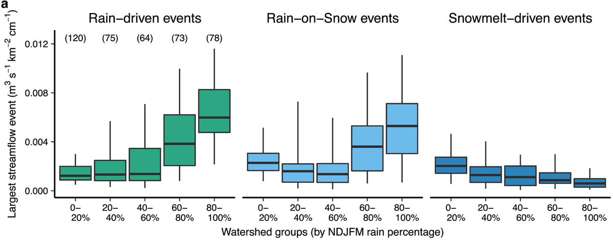
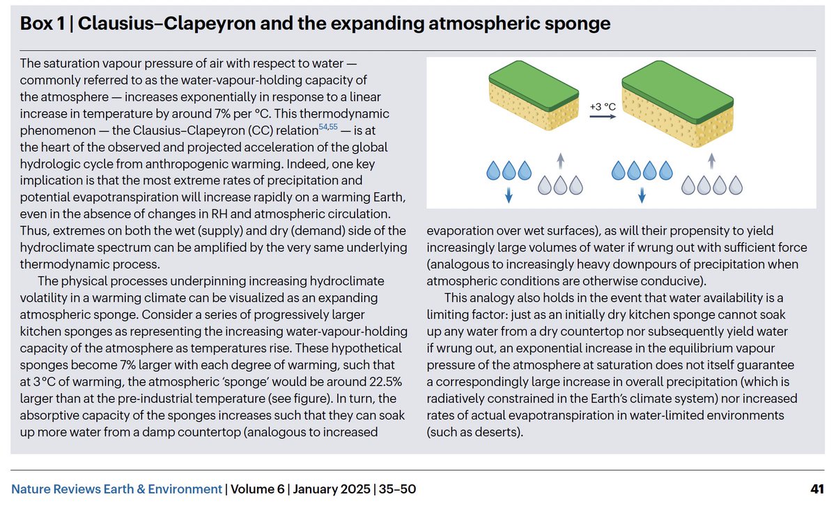
New work by Frances Davenport reveals "exponential response of streamflow to rain/snow fraction over western U.S. ... [implying] large potential for continued warming to increase flood risk, even without changes in precip frequency, magnitude, or timing." agupubs.onlinelibrary.wiley.com/doi/full/10.10… ImageImage
@StanfordEarth @MarshallBBurke @k_r_gonz @Stanford Considering that #AtmosphericRiver storms are already warming along the West Coast, this is a pretty big deal.
@StanfordEarth @MarshallBBurke @k_r_gonz @Stanford Also: the apparently quite large effect of increased rain vs. snow partitioning is emerging *in addition* to changes in the intensity, frequency, & seasonality of precipitation as the climate warms--likely further amplifying future increases in flood risk.

• • •

Missing some Tweet in this thread? You can try to force a refresh
 

Keep Current with Dr. Daniel Swain

Dr. Daniel Swain Profile picture

Stay in touch and get notified when new unrolls are available from this author!

Read all threads

This Thread may be Removed Anytime!

PDF

Twitter may remove this content at anytime! Save it as PDF for later use!

Try unrolling a thread yourself!

how to unroll video
  1. Follow @ThreadReaderApp to mention us!

  2. From a Twitter thread mention us with a keyword "unroll"
@threadreaderapp unroll

Practice here first or read more on our help page!

More from @Weather_West

Dec 14
A few notes on this morning's #Tornado Warning for San Francisco from @NWSBayArea (I am still traveling, so my live interactions are still somewhat limited):

1) Yes, a formal warning was issued by NWS for San Francisco this AM based on a suggestive radar signature. #CAwx [1/7]
@NWSBayArea 2) So far as I know, this was indeed first such warning ever issued for SF proper (but not first tornado in SF!). Other similar warnings have been issued elsewhere in Bay Area under similar conditions (i.e., offshore waterspout potentially moving ashore as tornado). #CAwx [2/7]
@NWSBayArea In 2005, for example, an EF1 tornado occurred in South Francisco, causing some notable damage. Other more significant tornado events have occurred elsewhere in the Bay Area and NorCal; although rare, they are not unprecedented. #CAwx [3/7]sfgate.com/bayarea/articl…
Read 7 tweets
Nov 18
A strong, prolonged, very moist, and relatively warm #AtmosphericRiver event, in conjunction with rapidly-strengthening #BombCyclone (yes, that's the term!), will bring major rain (and, locally, wind) impacts to OR/NorCal this week. Flooding is likely. #CAwx #ORwx #CAwater [1/6] Snapshot of 3-day accumulated IVT (integrated vapor transport) along the West Coast of North America from the GFS model. It depicts extremely high 72-hr accumulated IVT values aimed at far northern California coast.
First, a low pressure system west of OR and WA will undergo explosive deepening (rapid strengthening, known as "bombogenesis") over the next 2 days. It may become one of the strongest low pressure systems on record in this region. (~940mb) #CAwx #ORwx #CAwater [2/6] A map plot depicting the relative anomalousness of surface pressures over the northeastern Pacific Ocean later this week. There is a region of red west of WA and OR, indicating that the upcoming storm may bring some of the lowest surface pressures on record in this region.
This very strong low will generate hurricane-force sustained winds well offshore (& 50-60ft+ waves!). The strongest winds will remain well offshore, but damaging 70-90 mph gusts will still be possible in coastal OR & perhaps along far North Coast of CA. #CAwx #ORwx #CAwater [3/6] A plot showing predicted maximum wind gusts over time for Gold Beach, Oregon. Each horizontal strip depicts a different ensemble member from the ECMWF ensemble. Nearly all members depict wind gusts over 70mph during this event, with some approaching or exceeding 90 mph.
Read 7 tweets
Nov 16
Signs of some "big time" weather for TBD portions of U.S. West coast over next 10 days. A major #AtmosphericRiver, & perhaps a short sequence of very wet ARs, will affect some section of coast between NorCal & WA--perhaps bringing very heavy rain accumulations. #CAwx #ORwx [1/6] Map of ECMWF ensemble average precipitation accumulated over the next 10 days in the U.S. West. Heavy accumulations are depicted from far NorCal into Oregon and Washington.
First, it's important to consider the broader context. This autumn to date has been very (anomalously) dry across most of CA (except for far northern parts of state), but much less so in PacNW. It has also been broadly warmer than average across the West. #CAwx #ORwx [2/6] Map of temperature anomalies for the past 60 days across the U.S. from climatetoolbox.org. Nearly all areas are depicted as being warmer than average.
Map of precipitation anomalies for the past 60 days across the U.S. from climatetoolbox.org. Nearly all areas  in California are depicted as being drier than average except for the northenrmost part of the state.
In around 5 days, upstream Rossby wave breaking over the central North Pacific will set up a favorable pattern for cyclogenesis (storm development) in a position that will likely allow a strong #AtmosphericRiver to develop, likely tapping subtropical moisture. #CAwx #ORwx [3/6] Snapshot from most recent ECMWF model run of one possible orientation of the upcoming major atmospheric river event, depicting it making landfall near the OR/CA border.
Read 6 tweets
Oct 8
We are witnessing a genuinely extraordinary, and regionally quite deadly and destructive, period for extreme #weather in the United States. And, quite frankly, the fingerprints of #ClimateChange are all over what has transpired in recent weeks and may yet occur in coming days.
An incredible, ongoing, & increasingly record-shattering heatwave has plagued much of Southwestern U.S. for *weeks* now. Phoenix has now seen *2 consecutive weeks* with record temperatures *every day.* Many other locations have set new Oct and/or "heat streak" records.#CAwx #AZwx
Hurricane #Helene, which intensified very rapidly before making landfall in Florida's Big Bend, bringing record 15+ foot storm surge, then brought an even greater disaster in form of widespread, catastrophic flooding in Southern Appalachians. Hundreds are dead. #NCwx #TNwx #SCwx
Read 9 tweets
Sep 28
The images and stories just beginning to emerge from eastern TN and western NC in the aftermath of widespread catastrophic flooding wrought by #Helene are genuinely horrifying, and the full scale of the disaster is likely as yet untold. #TNwx #NCwx [Thread: 1/n]
20-30 inches--and perhaps locally 40+ inches--of rain fell along highest ridges of the Southern Appalachians due to 1-2 punch consisting of extreme "predecessor rain event" (PRE) that was historic in its own right followed by further extreme rain directly from #Helene. [2/n]
This was, by far, the most extreme rain event in observed record across much/most of the region, where reliable records date back over 100 yrs. Unsurprisingly, the flooding which resulted has also been widespread, historic, and generally catastrophic across a broad region. [3/n]
Read 19 tweets
Aug 19
For the first time since June in many parts of California and the broader Southwest, *cooler* than average temperatures can be expected for the next week, thanks in part to arrival of a *second* anomalously deep August low pressure system over NorCal Thu/Fri. #CAwx [1/4] ECMWF weather model depiction of anomalously low GPH near California later this week, representing an unusually deep summer low pressure center.
Another round of widespread rain & possible t-storms will occur in western WA & OR. In far NorCal, esp. northern mtns (Shasta region), some decent showers & t-storms are possible. Few showers/isolated thunder may reach farther south than last event--locally to I-80 corridor. #ORwx #WAwx #CAwx [2/4]ECMWF weather model depiction of cumulative precipitation across the American West this week, which shows a widespread wetting rainfall across the Pacific Northwest with more limited precipitation across portions of the northern third of California.
All of this will be fortuitous for fire season in western Washington and Oregon--mainly west of Cascades. While active fires will continue to east of Cascades, this may be season-ending precip (or close to it) for western WA and NW OR. #ORwx #WAwx [3/4]
Read 4 tweets

Did Thread Reader help you today?

Support us! We are indie developers!


This site is made by just two indie developers on a laptop doing marketing, support and development! Read more about the story.

Become a Premium Member ($3/month or $30/year) and get exclusive features!

Become Premium

Don't want to be a Premium member but still want to support us?

Make a small donation by buying us coffee ($5) or help with server cost ($10)

Donate via Paypal

Or Donate anonymously using crypto!

Ethereum

0xfe58350B80634f60Fa6Dc149a72b4DFbc17D341E copy

Bitcoin

3ATGMxNzCUFzxpMCHL5sWSt4DVtS8UqXpi copy

Thank you for your support!

Follow Us!

:(