A low pressure system off coast will move inland on Tuesday, bringing a widespread rain event to SoCal. This will be a warm/moist system with only modest dynamics, so almost everyone from Central Coast southward will see moderate rainfall of 0.5-2 inches. #CAwx
However, this system does have plenty of moisture (associated w/an #AtmosphericRiver focused to the south and east of CA) and some respectable atmospheric instability. As a result, there's actually a decent chance of thunderstorms w/brief heavy downpours on Tues in SoCal. #CAwx
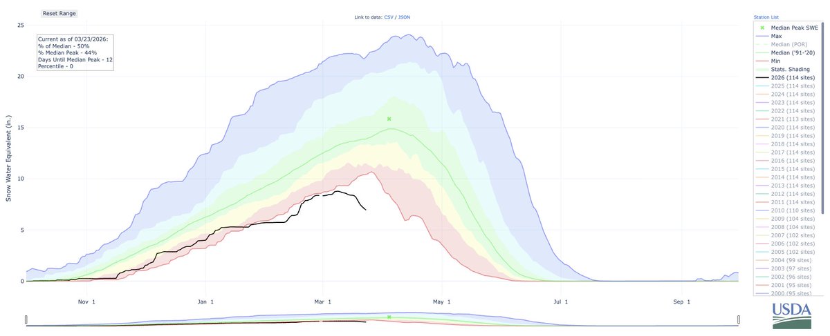
NorCal, unfortunately, will only see scattered showers from this system. A slightly more promising chance of colder showers (& maybe some Sierra Nevada snow) comes about a week from now--but in general, ensembles continue to suggest below-average precipitation in long range.#CAwx
• • •
Missing some Tweet in this thread? You can try to
force a refresh
A classic winter-like "tule fog" pattern will persist for at least a few more days in CA's Central Valley (w/spillover into SF Bay), but warm, dry, and mostly sunny conditions persist above and south of the fog layer! But how about some deeper tule fog context? [Thread] #CAwx
Folks are remarking on how this persistent Central Valley fog is "unprecedented." But that is *very* far from reality! While Nov is fairly early season for this pattern, dense & frigid "tule fogs" actually used to be *more* common, lasting days or even weeks in decades past. #CAwx
In fact, despite the damp chill in recent days, this isn't even an especially cold tule fog by historical standards! When I lived in Yolo County for a few years (almost 20 years ago! 👀), there were multiple occasions when temps never made it out of the 30s under the fog layer!
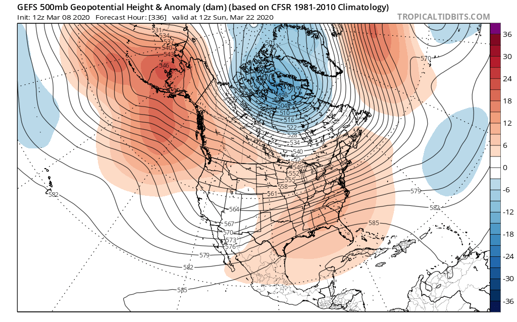
A high-amplitude flow pattern, characterized by near-record strength ridging and troughing (respectively) over the western and eastern U.S. and a very wavy jet stream, will bring a progression of notable weather to North America in the coming days.
Over the next few days, balmily warm temperatures will occur across western North America, including California (where temperatures into the 90s are likely in SoCal). Some record warm daytime temperatures are possible, & notably warm overnight temperatures will continue as well.
As the ridge-trough sequence reached maximum amplitude on Tue, very warm temperatures will continue in the West but anomalously cold temperatures will develop in the East. In fact, there may even be a day or two of record cold temps in parts of the Southeast.
I wanted to offer some thoughts on the Gates climate memo that has been circulating this week. While I can't directly speak for others, I can say that my own response is one of dismay & deep frustration (and that this view is shared by many climate/Earth scientists). [1/n]
I first want to emphasize that there are a few "kernels of truth" in this memo. More than kernels, even--there are whole sections/paragraphs with which I strongly agree! But there are multiple fatal flaws in its underlying premise, and thus in its conclusions. [2/n]
I strongly agree--both because I personally believe that it's the right thing to do and also because the evidence supports it--that rapidly addressing poverty, health inequity, and food/water insecurity should be a first-order priority. Full stop. No argument there. [3/n]
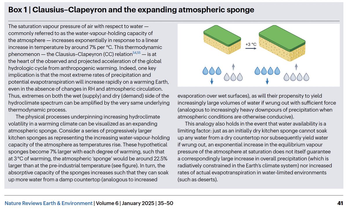
The discourse surrounding precipitation changes in a warming climate (both public discussion and even scientific one at times) is complicated by widespread conflation of changes in averages vs extremes (and also actual vs *potential* evaporation/evaporative demand). [Thread]
Increased temperatures rapidly raises "ceiling" on both precipitation & evaporation intensity--but same is *not* true for typical/average values of either! Regional mean precip can increase or decrease with warming, and actual evaporation is constrained by local H20 availability.
This is the basis for "Expanding Atmospheric Sponge" effect that we coined to help visualize practical implications stemming from more heavier downpours (i.e., flash floods) & also more extreme evaporative demand (e.g., faster-developing droughts, more intense wildfires).
And now: A thread regarding my thoughts on "1.5°C"--not only as a Paris Agreement target, but also re: relevance to recent #climate events & overlaps (or not) w/geophysical realities. (This was originally written as a response to a journalist, who used excerpts in their article.)
First and foremost, it's absolutely true that every tenth of a degree matters; each increment of global warming will bring a relatively larger increase in adverse societal and ecological impacts than the last.
This statement is not so much about rate of warming itself, but a reflection of growing recognition that Earth system (especially the biosphere and cryosphere) can respond non-linearly, and sometimes abruptly or even irreversibly on human timescales, to gradual shifts in climate.
There have been claims that NOAA/NWS did not foresee catastrophic TX floods--but that's simply not true. This was undoubtedly an extreme event, but messaging rapidly escalated beginning ~12 hrs prior. Flood Watch mid PM, "heads up" outlook late PM, flash flood warnings ~1am.
As always, this is not to blame the victims! Quite the opposite; this truly was a sudden & massive event and occurred at worst possible time (middle of the night). But problem, once again, was not a bad weather prediction: it was one of "last mile" forecast/warning dissemination.
I am not aware of the details surrounding staffing levels at the local NWS offices involved, nor how that might have played into timing/sequence of warnings involved. But I do know that locations that flooded catastrophically had at least 1-2+ hours of direct warning from NWS.