Dr. Daniel Swain Profile picture
May 28, 2020 4 tweets 3 min read Read on X
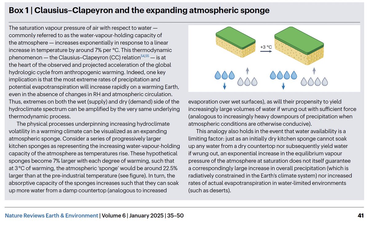
Very interesting weather set-up headed for NorCal this weekend. Heatwave breaks today near coast & tomorrow inland as cut-off low pressure system approaches coast. Then, late Fri into Sat, widespread elevated convection develops from SF Bay Area northward. (1/4) #CAwx #CAfire
This elevated convection will bring a good chance of thunderstorms, and the potential (at least initially) for some dry lightning--especially near I-80 corridor/Bay Area. Later storms on Saturday, and across far NorCal, will be wetter. #CAwx #CAfire (2/4) Image
In fact, models are now suggesting potential for locally heavy rainfall across far NorCal due to these widespread thunderstorms on Sat. This is an almost autumn-like convection pattern--storms will not be confined to usual spots, but will occur over valleys/coast too. #CAwx (3/4) Image
Finally, in addition to heat wave-breaking and possible fire weather impacts, I would expect Friday and Saturday to be exceptional cloud and sunrise/set watching days across all of NorCal. :) #CAwx (4/4)

• • •

Missing some Tweet in this thread? You can try to force a refresh
 

Keep Current with Dr. Daniel Swain

Dr. Daniel Swain Profile picture

Stay in touch and get notified when new unrolls are available from this author!

Read all threads

This Thread may be Removed Anytime!

PDF

Twitter may remove this content at anytime! Save it as PDF for later use!

Try unrolling a thread yourself!

how to unroll video
  1. Follow @ThreadReaderApp to mention us!

  2. From a Twitter thread mention us with a keyword "unroll"
@threadreaderapp unroll

Practice here first or read more on our help page!

More from @Weather_West

Oct 8
We are witnessing a genuinely extraordinary, and regionally quite deadly and destructive, period for extreme #weather in the United States. And, quite frankly, the fingerprints of #ClimateChange are all over what has transpired in recent weeks and may yet occur in coming days.
An incredible, ongoing, & increasingly record-shattering heatwave has plagued much of Southwestern U.S. for *weeks* now. Phoenix has now seen *2 consecutive weeks* with record temperatures *every day.* Many other locations have set new Oct and/or "heat streak" records.#CAwx #AZwx
Hurricane #Helene, which intensified very rapidly before making landfall in Florida's Big Bend, bringing record 15+ foot storm surge, then brought an even greater disaster in form of widespread, catastrophic flooding in Southern Appalachians. Hundreds are dead. #NCwx #TNwx #SCwx
Read 9 tweets
Sep 28
The images and stories just beginning to emerge from eastern TN and western NC in the aftermath of widespread catastrophic flooding wrought by #Helene are genuinely horrifying, and the full scale of the disaster is likely as yet untold. #TNwx #NCwx [Thread: 1/n]
20-30 inches--and perhaps locally 40+ inches--of rain fell along highest ridges of the Southern Appalachians due to 1-2 punch consisting of extreme "predecessor rain event" (PRE) that was historic in its own right followed by further extreme rain directly from #Helene. [2/n]
This was, by far, the most extreme rain event in observed record across much/most of the region, where reliable records date back over 100 yrs. Unsurprisingly, the flooding which resulted has also been widespread, historic, and generally catastrophic across a broad region. [3/n]
Read 19 tweets
Aug 19
For the first time since June in many parts of California and the broader Southwest, *cooler* than average temperatures can be expected for the next week, thanks in part to arrival of a *second* anomalously deep August low pressure system over NorCal Thu/Fri. #CAwx [1/4] ECMWF weather model depiction of anomalously low GPH near California later this week, representing an unusually deep summer low pressure center.
Another round of widespread rain & possible t-storms will occur in western WA & OR. In far NorCal, esp. northern mtns (Shasta region), some decent showers & t-storms are possible. Few showers/isolated thunder may reach farther south than last event--locally to I-80 corridor. #ORwx #WAwx #CAwx [2/4]ECMWF weather model depiction of cumulative precipitation across the American West this week, which shows a widespread wetting rainfall across the Pacific Northwest with more limited precipitation across portions of the northern third of California.
All of this will be fortuitous for fire season in western Washington and Oregon--mainly west of Cascades. While active fires will continue to east of Cascades, this may be season-ending precip (or close to it) for western WA and NW OR. #ORwx #WAwx [3/4]
Read 4 tweets
Apr 7
For folks in Colorado wondering what the heck is going on with #Xcel's large-scale pre-emptive power line de-energization to avoid wildfire ignitions during high wind events, I wanted to share a some thoughts as a scientist who studies climate/weather/wildfire. #COwx [1/n]
The first utility-scale "Public Safety Power Shut-offs" (#PSPS) in response to fire risk of which I'm aware began in 2010s in California in response to catastrophic wildfire events in urban interface sparked by power infrastructure during extreme fire weather/wind events. [2/n]
Such fires occur when energized lines fall to ground or trees fall onto live wires (igniting vegetation). They tend to be preferentially dangerous precisely because they occur under "worst case" conditions, when weather favors rapid spread & fire suppression is ineffective. [3/n]
Read 23 tweets
Feb 5
I wanted to reiterate some recent findings from our own research specifically addressing extreme #AtmosphericRiver storms in a warming climate.

1) CA will more extreme ARs in a warming climate, mainly (~80%) due water vapor increases. #CAwx #CAwater science.org/doi/10.1126/sc…
Image
2) Extreme CA ARs in a warming climate will not only be more intense, but they may also have preferentially more southerly (deep subtropical) origins (like present one!). #CAwx #CAwater science.org/doi/10.1126/sc…
Image
3) Integrated vapor transport, a measure of AR intensity, may increase at a "super Clausius-Clapeyron" rate (>>7%/C), especially over Southern California! #CAwx #CAwater science.org/doi/10.1126/sc…
Image
Read 10 tweets
Dec 5, 2023
Scientific institutions must create--and sustain--new kinds of roles so that researchers can provide the deep public engagement necessary to respond effectively to the escalating impacts of #climate change. The status quo isn't working. [Thread: 1/n] nature.com/articles/d4158…
My own role as a climate scientist-communicator is highly unusual in the academic world: I'm a practicing scientist who spends a large fraction (now over half) of my time engaging the public, and the rest of my time actually conducting research and writing papers. [2]
That engagement takes many forms. This year, I've given over 200 news interviews & worked with outlets behind the scenes to develop their coverage. I also work with state/federal agencies, brief members of state/national legislatures, and more. [3]
Read 13 tweets

Did Thread Reader help you today?

Support us! We are indie developers!


This site is made by just two indie developers on a laptop doing marketing, support and development! Read more about the story.

Become a Premium Member ($3/month or $30/year) and get exclusive features!

Become Premium

Don't want to be a Premium member but still want to support us?

Make a small donation by buying us coffee ($5) or help with server cost ($10)

Donate via Paypal

Or Donate anonymously using crypto!

Ethereum

0xfe58350B80634f60Fa6Dc149a72b4DFbc17D341E copy

Bitcoin

3ATGMxNzCUFzxpMCHL5sWSt4DVtS8UqXpi copy

Thank you for your support!

Follow Us!

:(