NWS Seattle Profile picture
Jun 8, 2020 3 tweets 4 min read Read on X
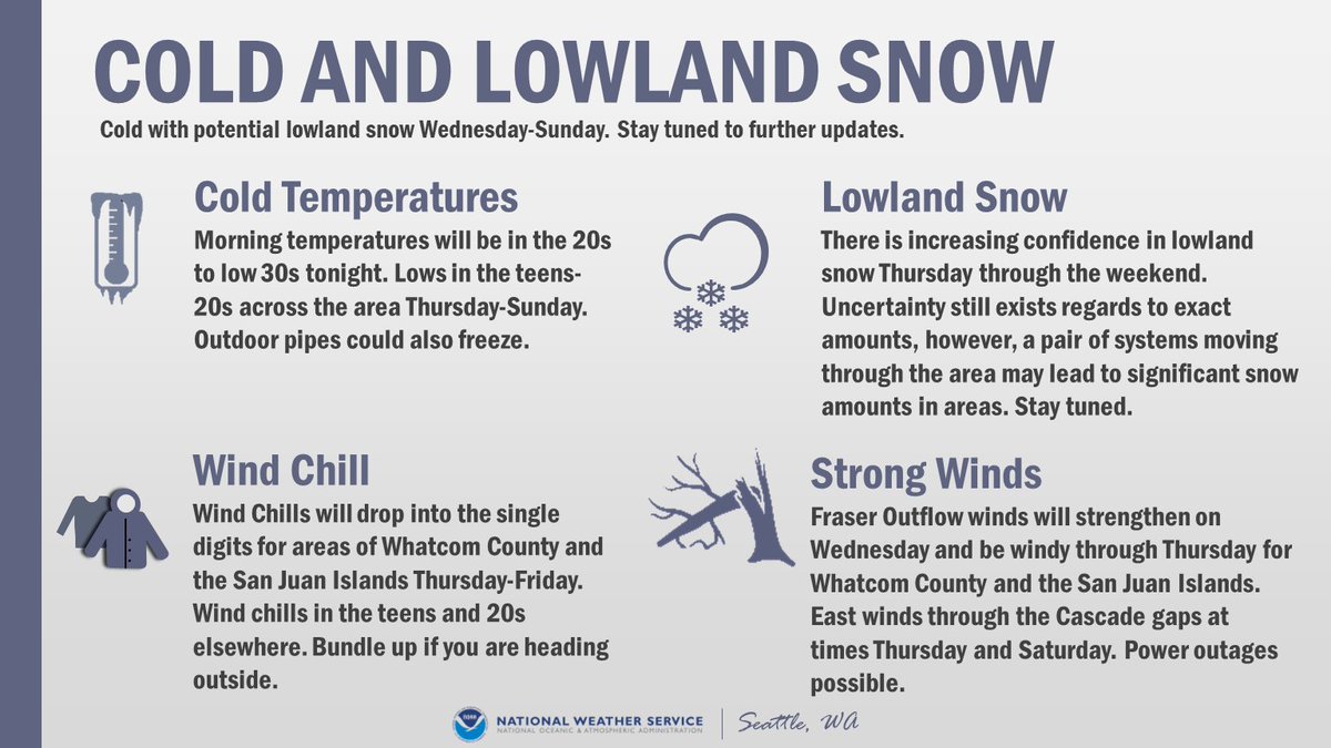
Strong #thunderstorm near #Issaquah, or 7 mi SE of #Carnation moving SE at 10 MPH. Winds in excess of 30 MPH & pea-sized #hail possible. Heavy rainfall with localized flooding also possible. #wawx
Update: Same storm now near #Snoqualmie & #NorthBend, moving SE at 5 MPH. #Lightning, pea-sized #hail, winds in excess of 30 MPH, & localized flooding possible with this storm. When thunder roars, go indoors! #wawx
Update: #Thunderstorm near #NorthBend moving SE at 15 MPH. #Selleck & #Hobart could also be impacted by this storm. #Lightning, pea-sized hail, 30 MPH winds, & localized flooding possible. #wawx

• • •

Missing some Tweet in this thread? You can try to force a refresh
 

Keep Current with NWS Seattle

NWS Seattle Profile picture

Stay in touch and get notified when new unrolls are available from this author!

Read all threads

This Thread may be Removed Anytime!

PDF

Twitter may remove this content at anytime! Save it as PDF for later use!

Try unrolling a thread yourself!

how to unroll video
  1. Follow @ThreadReaderApp to mention us!

  2. From a Twitter thread mention us with a keyword "unroll"
@threadreaderapp unroll

Practice here first or read more on our help page!

More from @NWSSeattle

Oct 14, 2022
Here's a meteorological explanation of WHY it will become so warm & smoky this weekend.

1) We've got a strong ridge of high pressure in the upper levels of the atmosphere. It's deflecting any weather away from us. It's also composed of sinking air that warms as it does so.
2) But it's more than what's happening aloft. Near surface weather is hugely impactful as well. High pressure east of Cascades is pushing air toward the coast. This is called offshore flow. At the same time, warm air expands north and westward over western Oregon and Washington.
3) This causes what's known as thermally induced low pressure to form and deepen near the ground surface. As the thermal trough strengthens west of the Cascades, a surface ridge strengthens east of the mountains.
Read 7 tweets
Jan 15, 2022
⚠TSUNAMI ADVISORY⚠

The National Tsunami Warning Center has issued a TSUNAMI ADVISORY for the Washington coast, resulting from a volcanic eruption near Tonga around 830pm Fri PST.

More information to follow.
This is for the outer coast, Strait of Juan de Fuca coast, and San Juan Islands.
What does this mean? Strong currents and larger waves are possible along these coastal areas. The first wave may not be largest.

What should you do? Move off the beach and out of harbors and marinas in these areas.
Read 5 tweets
Aug 8, 2021
As you can see on the map at weather.gov excessive heat watches are now up for later this week. Here in Western WA it will be hot Thursday through Saturday (but not as hot as it was at the end of June). Here in Seattle we should see three days in the lower to mid 90s.
Here are some specifics on the temperature ranges for the bulk of the heat wave. The main caveat of course, would be the impact of upper level smoke and haze. In the next tweet, you'll see the chances of records being tied or exceeded. #wawx
Here are the chances of records being tied or broken on Friday and Saturday at a few locations. The daily record at SeaTac on the 13th is 92 (2002) and 95 on the 14th (2010). #wawx
Read 4 tweets
Jun 29, 2021
STATE RECORD?! (1 of 3)
Multiple stations in Washington state yesterday recorded high temperatures that potentially tied or exceeded the all-time record high for the state of 118°F. #wawx
STATE RECORD?! (2 of 3)
In Western Washington this includes three stations: 118 at Sol Duc River near Forks, 118 at Mayfield Power Plant in Lewis County, and 120 near Renton. #wawx
STATE RECORD?! (3 of 3)
We will be participating in the State Climate Extremes Committee & conducting initial investigations of the sites & equipment locations. Representatives from @NWSPortland @NWSPendleton & @NWSSpokane will be doing similar investigations in their areas #wawx
Read 4 tweets
Feb 10, 2021
Another round of morning thoughts from the forecast desk:

- A modified arctic front will lead to a few snow showers mainly north of Seattle today.
- The front will bring cold, but increasingly drier air to much of the region on Thursday.
- The weather system on Thursday will be battling this very dry air.
- Because of this dry air in place, we expect the best snowfall accumulation potential Thursday afternoon and night will be south of Tacoma.
- This won't be a "one and done" situation.
- Another weather system arrives Fri night & Saturday A.M. This one has greater snowfall potential across a larger portion of Western WA.
- There is still some considerable uncertainty on amounts.
- Saturday's system is less a question of "Will it snow?", but rather "How much?"
Read 4 tweets
Feb 10, 2021
Alright everyone, let's discuss the active weather pattern for this week. Here are the main areas of focus:

🌨️Lowland Snow
🥶Cold Temperatures & Wind Chill
🌬️Locally Strong Winds Morning temperatures will be in the 20s to low 30s tonight.
The active weather pattern is expected from Wednesday through the weekend. Spotty snow showers Wednesday, with increasing snow Thursday morning. The potential exists for another round of snow Friday night into the weekend. However, there is uncertainty in the forecast. #WAwx
First call snow map for Thursday-Friday Morning:

Confidence is increasing in lowland snow for Thursday-Friday morning. Expect some adjustment to these snow amounts as we approach the event. Another round of snow potentially Friday night into the weekend. #WAwx
Read 7 tweets

Did Thread Reader help you today?

Support us! We are indie developers!


This site is made by just two indie developers on a laptop doing marketing, support and development! Read more about the story.

Become a Premium Member ($3/month or $30/year) and get exclusive features!

Become Premium

Don't want to be a Premium member but still want to support us?

Make a small donation by buying us coffee ($5) or help with server cost ($10)

Donate via Paypal

Or Donate anonymously using crypto!

Ethereum

0xfe58350B80634f60Fa6Dc149a72b4DFbc17D341E copy

Bitcoin

3ATGMxNzCUFzxpMCHL5sWSt4DVtS8UqXpi copy

Thank you for your support!

Follow Us!

:(