1/30
Catastrophic Uttarakhand Floods of 2013
Of a Himalayan Flood, the Monsoon, Western Disturbances, and a Dam that prevented further Devastation
Catastrophic Uttarakhand Floods of 2013
Of a Himalayan Flood, the Monsoon, Western Disturbances, and a Dam that prevented further Devastation

2/30
Between 16 and 18 June 2013 catastrophic flooding hit the Himalayan state of Uttarakhand in north India.
It devastated the upper reaches of the state, causing unprecedented death and destruction.
Between 16 and 18 June 2013 catastrophic flooding hit the Himalayan state of Uttarakhand in north India.
It devastated the upper reaches of the state, causing unprecedented death and destruction.
3/30
The area is home to some of India's holiest places.
Since it was summer, and monsoon was still a month away, “Chhota Chardham Yatra” to Badrinath, Kedarnath, Gangotri and Yamunotri was in full swing.
Sikh pilgrims also thronged to Hemkunt Sahib near Badrinath.
The area is home to some of India's holiest places.
Since it was summer, and monsoon was still a month away, “Chhota Chardham Yatra” to Badrinath, Kedarnath, Gangotri and Yamunotri was in full swing.
Sikh pilgrims also thronged to Hemkunt Sahib near Badrinath.
4/30
Uttarakhand has an area of ~53000 sq km.
The heavens opened up for two days over almost half of it. Many stations recorded rainfall over 30 cm.
Assuming 20 cm (avg) rainfall over 25000 sq km, the volume was ~5 cubic km.
That is 5000 billion litres of water!
Uttarakhand has an area of ~53000 sq km.
The heavens opened up for two days over almost half of it. Many stations recorded rainfall over 30 cm.
Assuming 20 cm (avg) rainfall over 25000 sq km, the volume was ~5 cubic km.
That is 5000 billion litres of water!
5/30
Where could all this water falling on peaks and glaciers at elevations of 7000 m or more go?
It flooded the drainage system – the streams and rivers.
Both Ganga and Yamuna systems are located here. These systems got flooded with the water.
Where could all this water falling on peaks and glaciers at elevations of 7000 m or more go?
It flooded the drainage system – the streams and rivers.
Both Ganga and Yamuna systems are located here. These systems got flooded with the water.
6/30
But there was more loss in areas flanking the Ganga system since it has many more pilgrim and tourist sites.
Nevertheless the Yamuna system was also affected. Delhi, 250 km away from Paonta where Yamuna emerges from the hills, was on the verge of being flooded.
But there was more loss in areas flanking the Ganga system since it has many more pilgrim and tourist sites.
Nevertheless the Yamuna system was also affected. Delhi, 250 km away from Paonta where Yamuna emerges from the hills, was on the verge of being flooded.
7/30
Ganga becomes Ganga at Devprayag, where its eastern tributary Alaknanda, merges with Bhagirathi, the western tributary.
Alaknanda itself originates at the confluence of Satopanth and Bhagirath Kirak Glaciers [4000 m], above Badrinath shrine.
Ganga becomes Ganga at Devprayag, where its eastern tributary Alaknanda, merges with Bhagirathi, the western tributary.
Alaknanda itself originates at the confluence of Satopanth and Bhagirath Kirak Glaciers [4000 m], above Badrinath shrine.

8/30
Floods in Alaknanda stranded 12000 pilgrims at Badrinath [3300 m] and 5000 at Hemkunt Sahib [4630 m].
Its confluences with Dhauli Ganga, Nandakini, Pindar and Mandakini at Vishnuprayag, Nandaprayag, Rudraprayag and Karnaprayag respectively, were also devastated.
Floods in Alaknanda stranded 12000 pilgrims at Badrinath [3300 m] and 5000 at Hemkunt Sahib [4630 m].
Its confluences with Dhauli Ganga, Nandakini, Pindar and Mandakini at Vishnuprayag, Nandaprayag, Rudraprayag and Karnaprayag respectively, were also devastated.
9/30
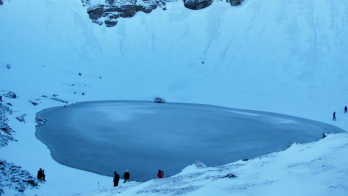
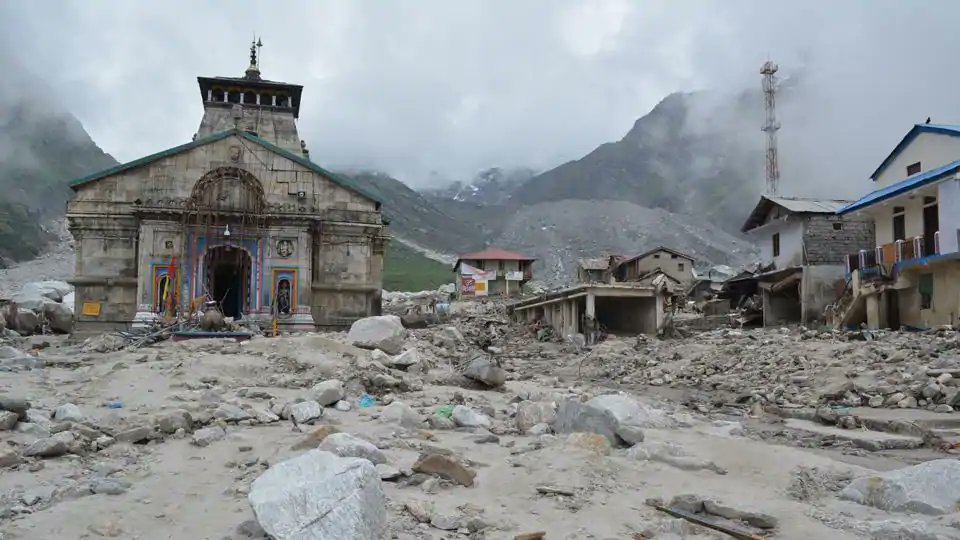
Mandakini emerges at Chorabari Glacier [~4,000 m] and flowed into Gandhi Sagar lake above Kedarnath.
The lake burst its banks and emptied in 10 minutes.
Boulders, mud and water not only ravaged the shrine, but also washed away pilgrims trekking there from Gaurikund.
Mandakini emerges at Chorabari Glacier [~4,000 m] and flowed into Gandhi Sagar lake above Kedarnath.
The lake burst its banks and emptied in 10 minutes.
Boulders, mud and water not only ravaged the shrine, but also washed away pilgrims trekking there from Gaurikund.
10/30
Now Bhagirathi, the western tributary.
It originates at Gaumukh on the Gangotri Glacier in Uttarkashi district.
On way to Devprayag, Bhagirathi flows into the Tehri Dam, one of India's highest dams.
And this made a crucial difference.
Now Bhagirathi, the western tributary.
It originates at Gaumukh on the Gangotri Glacier in Uttarkashi district.
On way to Devprayag, Bhagirathi flows into the Tehri Dam, one of India's highest dams.
And this made a crucial difference.
11/30
At Devprayag Alakananda was discharging ~7000 cu m /s, and water level had risen 11 m overnight.
Bhagirathi also had a similar discharge.
But Tehri Dam, which was almost empty at the beginning of the monsoon, contained the Bhagirathi, letting only 500 cu m/s out.
At Devprayag Alakananda was discharging ~7000 cu m /s, and water level had risen 11 m overnight.
Bhagirathi also had a similar discharge.
But Tehri Dam, which was almost empty at the beginning of the monsoon, contained the Bhagirathi, letting only 500 cu m/s out.
12/30
So at Rishikesh, the Ganga was carrying mainly water from Alaknanda and its tributaries.
Even that water devastated Rishikesh and Haridwar.
Had Tehri Dam not contained the Bhagirathi flood, devastation would have been much worse.
So at Rishikesh, the Ganga was carrying mainly water from Alaknanda and its tributaries.
Even that water devastated Rishikesh and Haridwar.
Had Tehri Dam not contained the Bhagirathi flood, devastation would have been much worse.
13/30
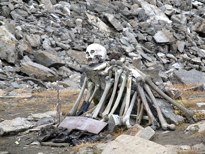
The flood caused loss of life and property in over 4,000 Himalayan villages in Uttarakhand.
Such was its fury that bodies of those washed away in the upper reaches were recovered as far downstream as Haridwar, Moradabad and even Allahabad.
The flood caused loss of life and property in over 4,000 Himalayan villages in Uttarakhand.
Such was its fury that bodies of those washed away in the upper reaches were recovered as far downstream as Haridwar, Moradabad and even Allahabad.
14/30
The map shows that though Alaknanda, Mandakini and Bhagirathi have different courses, the glaciers where they originate are all within a few km of each other.
And this was the area which witnessed continuous heavy rainfall over those 2 days.
(Google)
The map shows that though Alaknanda, Mandakini and Bhagirathi have different courses, the glaciers where they originate are all within a few km of each other.
And this was the area which witnessed continuous heavy rainfall over those 2 days.
(Google)

15/30
Why did this anomalously heavy rainfall occur, that too much before the normal arrival of the Monsoon in the area?
For this we need to understand Monsoon and other weather systems that affect North India.
First, the Monsoon.
Why did this anomalously heavy rainfall occur, that too much before the normal arrival of the Monsoon in the area?
For this we need to understand Monsoon and other weather systems that affect North India.
First, the Monsoon.
16/30
Summer warms the Indian Ocean.
But its eastern part (near Australia) still keeps getting cold Arctic water via the Pacific. The western part (near Africa/India) does not.
The resulting temperature difference between W and E waters is called “Indian Ocean Dipole”.
Summer warms the Indian Ocean.
But its eastern part (near Australia) still keeps getting cold Arctic water via the Pacific. The western part (near Africa/India) does not.
The resulting temperature difference between W and E waters is called “Indian Ocean Dipole”.
17/30
Warm air in the west rises up. It leaves low pressure on the surface.
Eastern waters are colder, and the pressure is higher there.
This east-west pressure difference drives moisture-laden winds from off-Australia towards Africa and India.
Warm air in the west rises up. It leaves low pressure on the surface.
Eastern waters are colder, and the pressure is higher there.
This east-west pressure difference drives moisture-laden winds from off-Australia towards Africa and India.
18/30
This is the Monsoon.
By end-May these winds reach India's southern tip.
India's landmass splits them into an “Arabian Sea Arm” and a “Bay of Bengal Arm”.
A low pressure line - the “Monsoon Trough” - joins the two arms.
This is the Monsoon.
By end-May these winds reach India's southern tip.
India's landmass splits them into an “Arabian Sea Arm” and a “Bay of Bengal Arm”.
A low pressure line - the “Monsoon Trough” - joins the two arms.
19/30
The Trough gradually advances northward till it covers entire India by middle of July.
Winds behind the Trough are from sea to land.
So western & peninsular India sometimes gets westerlies from Arabian Sea and sometimes easterlies from the Bay.
The Trough gradually advances northward till it covers entire India by middle of July.
Winds behind the Trough are from sea to land.
So western & peninsular India sometimes gets westerlies from Arabian Sea and sometimes easterlies from the Bay.
20/30
Eastern and northern parts get mostly easterlies from the Bay (the “Purvai” - पुरवाई - of folk songs in Bihar and UP).
Now the other phenomenon that affects weather in north India - “Western Disturbance”.
Eastern and northern parts get mostly easterlies from the Bay (the “Purvai” - पुरवाई - of folk songs in Bihar and UP).
Now the other phenomenon that affects weather in north India - “Western Disturbance”.
21/30
Western Disturbances (WD) are low pressure areas which start over Mediterranean Sea, Caspian Sea, or even North Atlantic, usually in the winter, and move east towards the Himalayas, riding the Jet Stream in earth's atmosphere.
Western Disturbances (WD) are low pressure areas which start over Mediterranean Sea, Caspian Sea, or even North Atlantic, usually in the winter, and move east towards the Himalayas, riding the Jet Stream in earth's atmosphere.
22/30
They bring rain in areas from Iraq to Pakistan.
As they hit the Himalayas, around Punjab they get inhibited and cause rains in northwest India.
Most of the winter rains necessary for the Rabi crop in north India is due to Western Disturbances
They bring rain in areas from Iraq to Pakistan.
As they hit the Himalayas, around Punjab they get inhibited and cause rains in northwest India.
Most of the winter rains necessary for the Rabi crop in north India is due to Western Disturbances
23/30
As a WD slows down in Punjab, it gets trapped by Himalayas on its north. Low pressure inside it often draws air from the south (Rajasthan), inducing a circulation which sometimes extends all the way south to the Arabian Sea.
As a WD slows down in Punjab, it gets trapped by Himalayas on its north. Low pressure inside it often draws air from the south (Rajasthan), inducing a circulation which sometimes extends all the way south to the Arabian Sea.
24/30
Now let us see why heavy rain occurred over western and central Uttarakhand between 16-18 June 2013.
Monsoon hit Kerala on its normal date of 1st June that year.
On 12th June however a low pressure area formed in the Bay, off the Odisha coast.
Now let us see why heavy rain occurred over western and central Uttarakhand between 16-18 June 2013.
Monsoon hit Kerala on its normal date of 1st June that year.
On 12th June however a low pressure area formed in the Bay, off the Odisha coast.
25/30
This low pressure rapidly moved NW, pulling the monsoon trough with it.
In six days (on 16 June) it reached Northeastern Rajasthan.
Monsoon had covered the country in just 15 days instead of the usual 45 - its fastest advance since 1941.
This low pressure rapidly moved NW, pulling the monsoon trough with it.
In six days (on 16 June) it reached Northeastern Rajasthan.
Monsoon had covered the country in just 15 days instead of the usual 45 - its fastest advance since 1941.

26/30
As the Monsoon Trough was moving in from the Bay, a Western Disturbance was moving in from Pakistan.
The WD reached Punjab by 16 June, and induced a cyclonic circulation to its south which extended all the way to the Arabian Sea, feeding more moisture to the WD.
As the Monsoon Trough was moving in from the Bay, a Western Disturbance was moving in from Pakistan.
The WD reached Punjab by 16 June, and induced a cyclonic circulation to its south which extended all the way to the Arabian Sea, feeding more moisture to the WD.

27/30
The two systems - WD and the Monsoon - converged on 16 June around the Rajasthan-Haryana border.
The system was now fed by moisture from Europe, the Bay and from Arabian Sea.
And there was high pressure in Tibet which kept the moisture trapped south of the Himalayas.
The two systems - WD and the Monsoon - converged on 16 June around the Rajasthan-Haryana border.
The system was now fed by moisture from Europe, the Bay and from Arabian Sea.
And there was high pressure in Tibet which kept the moisture trapped south of the Himalayas.

28/30
The trapped moisture rose up, condensed and precipitated over west-central Uttarakhand.
Carried by the now sluggish WD the converged system moved east very slowly.
As a result heavy precipitation continued for a full two days, causing the floods.
The trapped moisture rose up, condensed and precipitated over west-central Uttarakhand.
Carried by the now sluggish WD the converged system moved east very slowly.
As a result heavy precipitation continued for a full two days, causing the floods.
29/30
The floods were devastating.
But the situation could have been much worse had Tehri dam not been there.
The discharge into the Ganga at Devprayag would then have doubled because of the Bhagirathi flood.
Lower Uttarakhand and UP would have been devastated.
The floods were devastating.
But the situation could have been much worse had Tehri dam not been there.
The discharge into the Ganga at Devprayag would then have doubled because of the Bhagirathi flood.
Lower Uttarakhand and UP would have been devastated.
30/30
Dams are justifiably criticised for ecological, seismological and human reasons.
But during those two days it was Tehri Dam which saved the plains of Western UP from even more unimaginable disaster.
--- ENDS ---
Dams are justifiably criticised for ecological, seismological and human reasons.
But during those two days it was Tehri Dam which saved the plains of Western UP from even more unimaginable disaster.
--- ENDS ---
@threadreaderapp unroll