Capital Weather Gang Profile picture
Aug 3, 2020 4 tweets 3 min read Read on X
#Isaias and DC-MD-VA! Short thread...
* Tropical storm and flash flood watch out for large parts of the region
* High confidence in heavy rain. NWS has INCREASED our rain forecast to 4-6" along I-95 corridor, 2-4" to west, 5 to 7" east. (1/x) Image
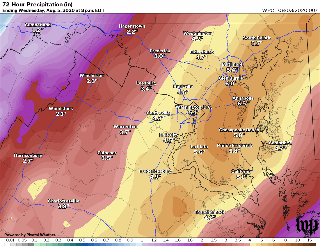
Heaviest rain from #Isaias in DMV expected Mon night to Tues evening.

Strongest winds forecast Tuesday afternoon - esp in the afternoon as core of storm comes closes. Expect strongest winds (30-55 mph gusts) EAST of I-95 near Bay and Delmarva unless storm shifts west. (2/x) Image
Models pretty consistent forecasting #Isaias to track east of DC. But rain & winds will expand as it merges with stalled front & is captured by jet stream.
In unlikely event storm takes more western route, would increase chance of tropical storm winds in immediate DC area. (3/x) Image
Main concerns for #Isaias in DMV:
* Flooding rain overnight Mon into Tues
* Combo of rain and wind near Bay/Delmarva causing downed/trees outages
* Coastal flooding from minor surge (1-3') Old Town, SW Waterfront, Annapolis
Detailed briefing: wapo.st/3k1LSVb (4/4)

• • •

Missing some Tweet in this thread? You can try to force a refresh
 

Keep Current with Capital Weather Gang

Capital Weather Gang Profile picture

Stay in touch and get notified when new unrolls are available from this author!

Read all threads

This Thread may be Removed Anytime!

PDF

Twitter may remove this content at anytime! Save it as PDF for later use!

Try unrolling a thread yourself!

how to unroll video
  1. Follow @ThreadReaderApp to mention us!

  2. From a Twitter thread mention us with a keyword "unroll"
@threadreaderapp unroll

Practice here first or read more on our help page!

More from @capitalweather

Nov 13, 2024
New today: Capital Weather Gang's winter outlook. We lean toward slightly below normal snow this winter in DC but more than we've seen in the last several winters -- which have produced very low numbers. 1/x Image
The main reason most winter outlooks are calling for below normal snow for the DC area is because of La Nina, which -- on average -- brings below normal amounts. But this La Nina will probably be weak, if it develops at all. We think its influence may be limited. 2/x Image
That said, we'd be surprised if this is a banner year for snow lovers and think the prevailing storm track will be west of DC, meaning storms may start as snow or ice but flip to rain. 3/x Image
Read 4 tweets
Sep 1, 2024
Maps, we love maps. They help tell the story of the summer.

First, here are all of the locations which had one of their top 5 hottest summers - June thru Aug - on record. DC is among them.

1/5 Image
Here all the places that highs of 100+ and the number of times. Some places in the Southwest like Phoenix and Yuma were 100+ pretty much every day.

2/5 Image
Over 250 places with at least 20 years of data set all-time highs during summer. They include Las Vegas; Fresno; Abilene, Tex.; Raleigh; Hagerstown, Md; and Caribou, Maine.

3/5 Image
Read 5 tweets
May 13, 2024
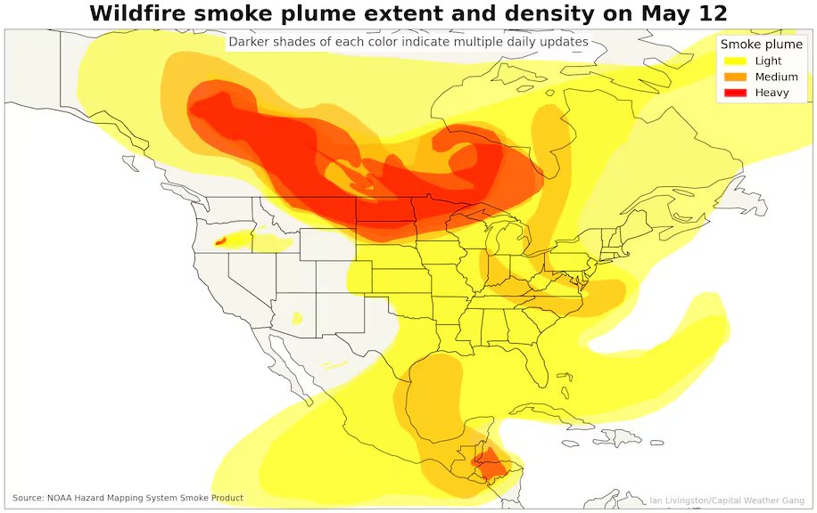
Crazy -- and not in a good way -- wildfires in Canada have erupted (fueled by warm, very dry conditions) -- just like they did at this time last year, and sending smoke into the Upper Midwest, where air quality is tanking. 1/4 Image
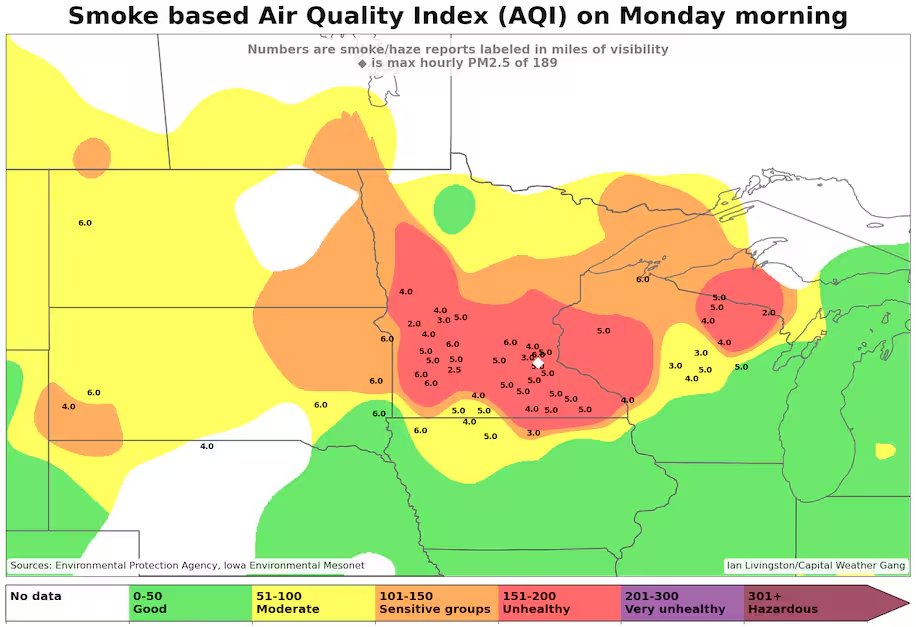
Code red air quality -- signifying unhealthy levels of smoke pollution -- in Minnesota and Wisconsin this morning. Parts of southwest Canada have seen Code Purple air quality-- the worst level. 2/4 Image
The fires are spreading fast because of widespread drought in Canada. Also, of note, even worse drought and record heat in Mexico are causing fires to spread and smoke is infiltrating the U.S. from the south, too!!! 3/4 Image
Read 4 tweets
Aug 7, 2023
⚠️DC area: We expect intense storms that could produce damaging or destructive winds -- especially in 5-7p window in immediate area.

Our detailed brief is up. Read it and share it:


Will thread some key points... 1/xwashingtonpost.com/weather/2023/0…
We are under a level 4 out of 5 risk. The last time that happened locally was June 13, 2013; the previous time before that was the June 29, 2012 derecho. So the @NWSSPC sees ingredients in place for numerous dangerous storms in the area.

2/x Image
@NWSSPC We're most concerned about:
1) Downburst winds -- like we saw July 29 this year. @NWSPC sees 45% chance of winds over 58 mph within 25 miles of any point in our area & 10% chance of 75+ mph
2) Quick-hitting tornadoes -- a lower chance than downburst winds but possible

3/x Image
Read 5 tweets
Jun 23, 2023
Communities are taking part in a radical revolution — of our lightbulbs. Bulbs are being swapped for more energy-efficient brighter LED lights.

But the rise of LEDs creates new issues for our night sky & health.

By @KashaPatel, @sadbumblebee, @kt_prry: wapo.st/3r3mNB3
Common types of LED lights emit more blue light than traditional high-pressure sodium bulbs. Differences are seen in this 2020 image from the Space Station. Bluer LEDs appear in Baltimore, while older amber-colored lights spread across D.C.

More: https://t.co/7TyF7WcYnCwapo.st/3r3mNB3
The blue light in LEDs can lead to more light pollution. In Chelan County in Wash, pollution grew worse after streetlights were replaced w/LEDs. Additional glare masked about half the previously visible stars:

📷@PostGraphics w/National Park Service data https://t.co/xtVNOw2KlCwapo.st/3r3mNB3
Read 5 tweets
Jun 12, 2023
This wildfire season in Canada is unlike anything it's ever seen to date. And part of a trend toward larger fires & more damaging fire seasons.

4.7 million hectares have burned; average year to date is 310,000.

Carbon emissions from fires through the roof

(1/5) Image
The land area burned so far in Canada has exceeded 5,000 percent of normal in some provinces. (2/5) Image
Some climate skeptics - to dismiss this year's fire activity - have pointed to decrease in number of fires in Canada over time. That is true, but prob b/c of improved prevention.

BUT, fires that burn have trended substantially BIGGER while summer temps have trended higher. (3/5) Image
Read 6 tweets

Did Thread Reader help you today?

Support us! We are indie developers!


This site is made by just two indie developers on a laptop doing marketing, support and development! Read more about the story.

Become a Premium Member ($3/month or $30/year) and get exclusive features!

Become Premium

Don't want to be a Premium member but still want to support us?

Make a small donation by buying us coffee ($5) or help with server cost ($10)

Donate via Paypal

Or Donate anonymously using crypto!

Ethereum

0xfe58350B80634f60Fa6Dc149a72b4DFbc17D341E copy

Bitcoin

3ATGMxNzCUFzxpMCHL5sWSt4DVtS8UqXpi copy

Thank you for your support!

Follow Us!

:(