The secondary (and first, presumably) explosion in Beirut happened at the Beirut Port Silos, geolocation: 33.902226, 35.518766. google.com/maps/@33.90223…
There are reports of two explosion locations, one in downtown Beirut and one in the port, mentioned above. Here's a closer look at (one?) of the explosions at the port.
It's still unclear what caused the explosion, but this video clearly shows what magnitude it had.
Lebanese Army sources tell @sewella that it was *possibly* a burning container of fireworks, and the fire spread to a nitrate warehouse:
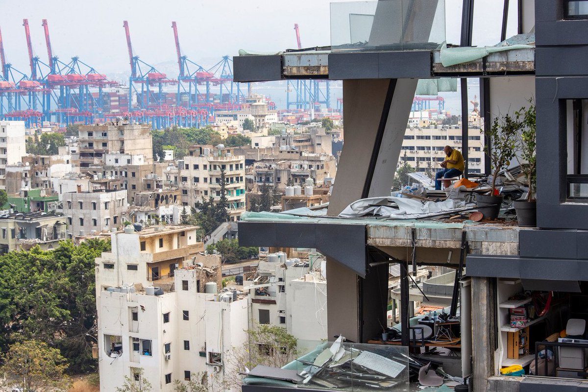
Satellite imagery collected by @Maxar this morning over Beirut clearly shows the power of the explosion with a large crater visible at the primary blast location, extensive destruction throughout the area and a capsized passenger ship.
How could ammonium nitrate, a common fertilizer, have caused the major explosion in Beirut? If placed under stress of heat and pressure — and negligence — it acts like a bomb. Useful explainer here by @johnismay, with input from @BrianCastner and others. nytimes.com/2020/08/05/wor…
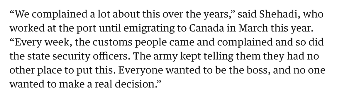
Between 30 to 40 nylon bags of fireworks were stored in the same warehouse as 2,750 tonnes of ammonium nitrate, a former port worker and other sources have told @guardian. “We complained a lot about this over the years.“ theguardian.com/world/2020/aug…
The ammonium nitrate that blew up in Beirut was left by M/V RHOSUS, an ailing ship whose fate was unclear. Until now. @ckoettl found out that it sank in early 2018, and has been submerged a mere 1,500 feet away from the warehouse that exploded. Read/watch: nytimes.com/2020/08/07/wor…
A photo from 2014 shows the M/V RHOSUS with some of the 2,750 bags of ammonium nitrate in Beirut's port. These bags match the bags photographed later at the warehouse that eventually blew up, tweeted yesterday by @DimaSadek. nytimes.com/2020/08/07/wor…
Check out my colleague @ckoettl's thread on how he tracked and found the M/V RHOSUS, including this satellite image which was taken around the day the ship sank.
The U.S. in is in the process of seizing OLINA in the Caribbean near Trinidad, per @Reuters. It's flying a false flag of Timor Leste. It's loaded with oil cargo from Venezuela, per @Kpler and @TankerTrackers. And last known location is 12.16769, -62.6113, per @oballinger.
The tanker was hit by U.S. sanctions last year in re: Russia’s war in Ukraine. At the time, it was named MINERVA M, but it can still be identified by its IMO number, 9282479, which appears in related references. OFAC: ofac.treasury.gov/recent-actions… Reuters: reuters.com/business/energ…
A U.S. Coast Guard and Navy team has boarded and seized the vessel, per @EricSchmittNYT. nytimes.com/live/2026/01/0…
NEW: The United States is pursuing several oil tankers across the Atlantic after a mass departure from Venezuelan waters this weekend. Most of the ships are carrying oil; one flies the Russian flag.
The ships now crossing the Atlantic are part of a larger group of 16 sanctioned tankers we reported on a few days ago, which departed Venezuelan waters en masse in defiance of the U.S.’s partial naval blockade.
We wondered where those ships went. Thanks to @oballinger, who wrote a computer program to detect vessels in @CopernicusEU satellite images, we were able to identify the whereabouts of 8 vessels: 3 in the Atlantic heading east, and 5 in the Caribbean heading northeast.
We just found out that, in addition to MARINERA and HYPERION, three other tankers recently in Venezuelan waters — and previously hit by U.S. sanctions for shipping Iranian/Russian oil —are now officially flying the Russian flag. More: nytimes.com/live/2026/01/0…
1 - VERONICA (9256860), now renamed to GALILEO, with homeport Taganrog. The vessel was sanctioned by the U.S. in 2022 following the full-scale invasion of Ukraine. Empty of oil cargo per @Kpler and @TankerTrackers. This vessel is one of 16 mentioned here.
2 - DIANCHI (9281011), now renamed to EXPANDER, home port Sochi. Vessel was sanctioned by the U.S. in early 2025 for shipping Russian oil. Loaded with Venezuelan oil at the moment, per @Kpler and @TankerTrackers. 🛰️📸: @planet
BREAKING: Multiple oil tankers hit by U.S. sanctions appear to be making a coordinated attempt to break the U.S. naval blockade on Venezuela’s energy exports by departing all at once. w/ @AKurmanaev nyti.ms/4sreZEs
Rubio said the blockade is one of the largest “quarantines” in modern history. But reporting by @AKurmanaev inside Venezuela, along with analysis from @TankerTrackers and myself, shows at least 16 tankers appear to be defying Trump’s “complete blockade.”
Four oil tankers left port without authorization from Venezuela’s interim government, according to internal communications from state oil company PDVSA and two industry sources. These departures could be an early act of defiance of interim President Delcy Rodríguez’s control.
A Syrian expat was dining at Sixty, a restaurant at the top of a Moscow skyscraper, when waiters asked him not to take any photos. The diner looked around to see who the VIP was. It was Bashar al-Assad. Our story on the family’s life in exile: nyti.ms/45oxhML
The deposed president and his family lives are posh. He went from a suite at the Four Seasons (up to $13K/week) to a penthouse in Federation Tower, and finally to a villa in Rublyovka — a secluded suburb popular with the Russian elite.
While Syria tries to rebuild, Assad relatives are burning cash. Social media posts we found offer a glimpse: Sham al-Assad, daughter of Maher, celebrated her birthday over multiple days in Dubai, with a dinner at the gold-tiled Bagatelle and gifts from Hermès, Chanel and Dior.
Satellite images of El Fasher, Sudan, taken today, Oct. 30, by @vantortech, show the aftermath of the RSF brutal takeover of the city this weekend. This is around the airport. Coordinates: 13.628, 25.329
Before and after of a road northwest of El Fasher, including numerous burned vehicles. Coordinates: 13.713, 25.278. Via @vantortech.
@vantortech Before and after views of the Children's Hospital in El Fasher. Credit: @vantortech. Coordinates: 13.621, 25.382.