Christiaan Triebert Profile picture
Visual Investigations at @nytimes. Previously with @Bellingcat, @Airwars. DMs open.
20 subscribers
Dec 17 5 tweets 2 min read
New @Maxar satellite imagery from the past 48 hours shows the Russian military vehicles and equipment continue to be withdrawn from Khmeimim Air Base, and likely arrived at the Tartus naval base. Thread 🧵 This image from December 15 shows military trucks, armored personnel carriers (APC) and personnel assembled on the tarmac at Khmeimim Air Base. An Il-76 transport aircraft is parked nearby. 🛰️📸: @Maxar Image
Dec 12 5 tweets 2 min read
This satellite image from today, via @Maxar, shows three key vessels in Iran's strategy of converting commercial ships into military platforms ancored near Bandar Abbas:

SHAHID BAGHERI (new drone ship, probable net-covered drone on deck)
SHAHID MAHDAVI
SHAHID ROUDAKI Image This is a closer crop of the SHAHID BAGHERI, the newest of the three. Originally a commercial container ship, the vessel was converted into a military drone carrier and is now undergoing its first sea trials after departing the ISOICO shipyard in late November, per @Maxar. Image
Dec 10 7 tweets 3 min read
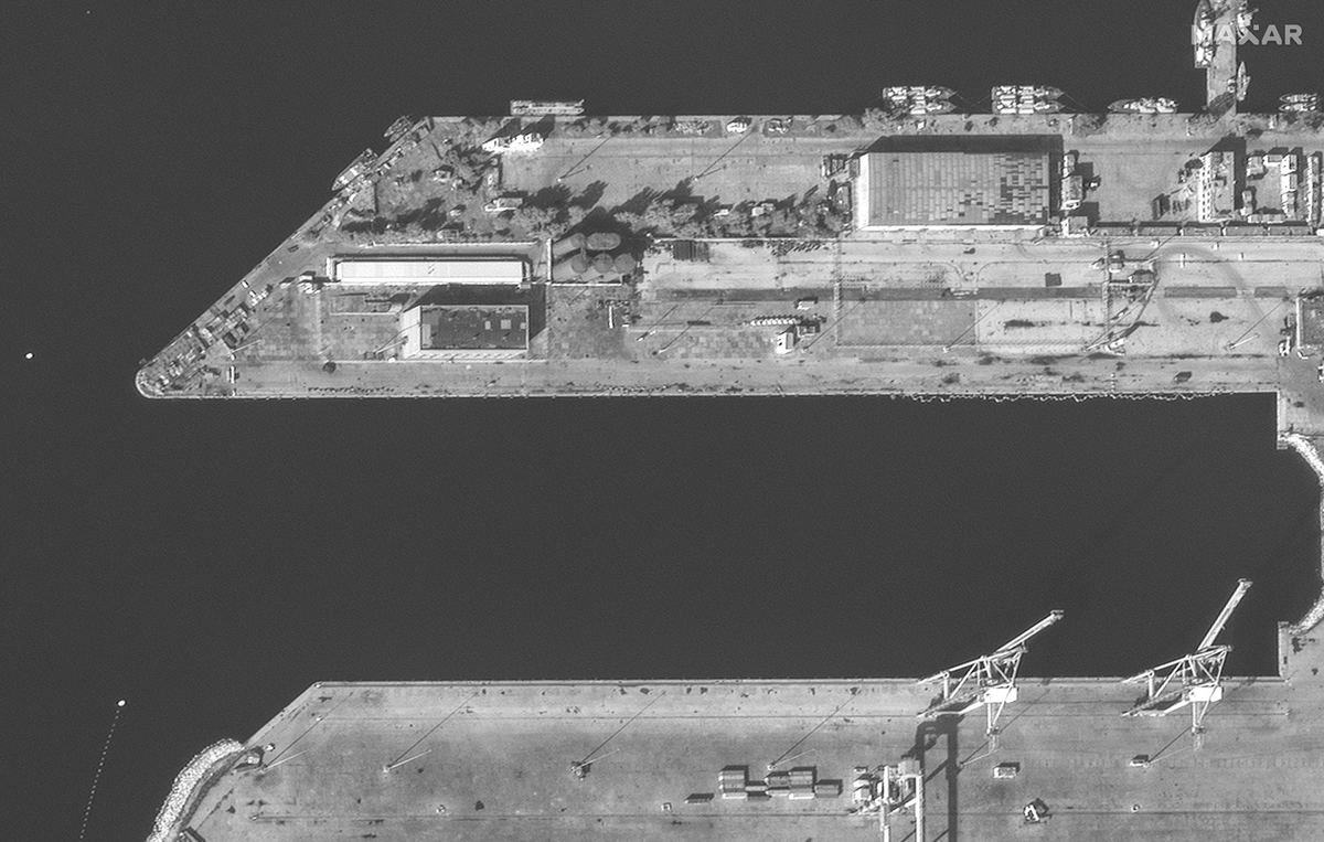
New high-resolution satellite imagery from @Maxar of the key Russian location in Syria: the Tartus naval base and the Khmeimim airbase near Latakia. 🧵 Nearly all Russian naval assets have left their usual positions at the Tartus port base, as @riley_mellen and I reported for @nytimes yesterday. nytimes.com/live/2024/12/0…Image
Image
Nov 9 9 tweets 6 min read
Young Dutch journalist @OmeBender filmed Maccabi Tel Aviv fans in Amsterdam stealing steel pipes, putting on masks, and chasing someone. A metal pipe appears to be thrown at a police vehicle. The footage also shows an Israeli fan warning him to stop filming. The incident shown in the clip above of the Maccabi fans chasing someone is the same one as seen in this video. This happened after the match, around midnight, in front of Centraal Station.
Nov 1 6 tweets 3 min read
Since it didn't make it into this story, threading some geolocations of airstrikes near Tinzaouaten by Turkish-made drones. These strikes could be conducted by Mali and/or Burkina Faso. Overview map. Pink line is Wagner's route toward Tinzouaten, pink pins are location of first battle, green line is earth berms around the gold mines, and yellow pins are the drone strikes. Image
Nov 1 35 tweets 12 min read
In July, Wagner suffered its biggest defeat in Africa. Our visual investigation, using satellite imagery, battlefield footage and firsthand accounts, shows a moment-by-moment breakdown of what happened — and the fallout with families in Russia. nyti.ms/3Yx2Orx Please read the full article for our main findings. In this thread, I’ll share extra details that didn’t make the story — focusing on geolocations, messages from family members and some insight on what’s going on with Wagner after the mutiny and Prigozhin’s death.
Oct 19 6 tweets 4 min read
Worth checking out: @SkyTruth has released renewed three oil and gas monitoring tools: Cerulean (AI-powered ocean oil pollution detection), Monitor (environmental change tracking), and the Natural Gas Flaring Map. Links in thread. Cerulean uses satellite imagery to track ocean oil pollution and identify potential sources. An initial analysis revealed more than 1K oil slicks from vessels, suggesting that ships may be dumping more than 80 million gallons of oily sludge annually. cerulean.skytruth.orgImage
Image
Sep 27 14 tweets 6 min read
For what it's worth, the IDF live-streamed its press conference on today's strikes in Beirut to YouTube. Instead of using their official account, they uploaded it as an unlisted video to the channel ”siteolympus9593”.

Image
Image
At least two large apartment buildings in the densely populated southern Beirut suburbs, known as Dahiya, were flattened. Lebanon's health minister said two to four additional buildings had been “completely decimated.” nytimes.com/live/2024/09/2…

Satellite image showing buildings in Beirut, Lebanon, with two structures highlighted and labeled "Buildings known to be flattened in strike." The inset map at the bottom right shows the location of the strike within the city of Beirut. The image credits are given to Airbus via Google Earth, as published by The New York Times.
Sep 18 12 tweets 5 min read
Another series of explosions has been reported across Beirut and other parts of Lebanon, this time involving ICOM communication devices that appear to be exploding.

Image
Image
Based on its appearance and the visible markings, this device seems to be the ICOM IC-V82 model. rigpix.com/icom/icv82.htm

Image
Image
Jul 31 7 tweets 3 min read
Geolocation of the building in northern Tehran where Ismail Haniyeh was reportedly assassinated: 35.81931, 51.41559. An Iranian official shared the image with @farnazfassihi, and it is circulating on Telegram. Green cloth and rubble is visible on the east side of the building. Image A satellite image captured by @Maxar on July 25 does not show the green cloth or the rubble on the first-floor roof, suggesting that the image above that's circulating is recent indeed. The building is adjacent to the Saadabad Palace, and near the president's official residence. Image
May 21 14 tweets 5 min read
In recent months, one of Haiti's most powerful gangs — 5 Segonn — promoted itself with brash rap videos. Recently, however, the gang has obtained better weapons and is presenting itself as a paramilitary force. Our visual investigation takes a deep dive: nyti.ms/4bPiJXx
The rise of Haitian gangs started a few decades ago, when they were used by politicians to suppress voter turnout or anti-government protests, and by oligarchs for land grabs and attacks on rivals. Now, they've found independent financial lifelines, changing the dynamic.
Mar 16 4 tweets 2 min read
Satellite imagery of Port-au-Prince, captured on March 14, shows the deteriorating conditions in Haiti's capital due to ongoing gang violence. This image (wide and crop) show roadblocks, burning debris and trash blocking Rte de Delmas near the city's main hospitals. Image: @Maxar
Image
Image
Smoke can be seen rising near St. Francois de Sales hospital, in Port-au-Prince, March 14, 2024. Image: @Maxar. A unified front of gangs forced Haiti's prime minister to resign. More: nytimes.com/2024/03/14/wor…
Image
Feb 16 8 tweets 4 min read
The Biden admin has hailed its efforts to restrict Iran's oil revenue — and its ability to fund proxy militias. But lax government oversight allowed deceptive tankers to move $2.8 billion worth of oil, all with American insurance. Our visual investigation: nyti.ms/3I0dQOr Since this investigation — with @BlackiLi, @_neilbedi, @ajcardia and @bottidavid — relied heavily on openly available online sources and tools, I wanted to give some insights in our reporting process below.
Aug 1, 2023 11 tweets 5 min read
Just moments ago, reports of yet another drone attack in Moscow (early hours of August 1), making it the fourth attack in the span of just one week. Threading details as they emerge below: This video shows smoke rising at a skyscraper in Moscow City, a symbol of Russia's economic resurgency under Putin. The area was also hit by a suspected Ukrainian-made Bober drone on July 30. https://t.co/4fdGOS8yDnt.me/ENews112/14811
Jul 31, 2023 17 tweets 6 min read
“The only way to stop this,” Ukraine's military intelligence told us, “is the immediate withdrawal of Russian occupation troops from Ukraine.” Our latest visual investigation into Kyiv's growing fleet of homegrown kamikaze drones that have hit Moscow: nyti.ms/455tphc Public glimpses of Ukraine's long-range kamikaze drone program are rare. The first came in December, when influencer @igorlachenkov got an unexpected phone call from GUR, Ukraine's military intelligence. They needed money, and fast, for a “drone that can fly very far.”
May 31, 2023 31 tweets 17 min read
We tracked how several tankers, all acquired by shell companies after Russia invaded Ukraine, secretly moved at least half a billion dollars worth of Russian oil — an apparent effort to deceive their U.S.-based insurer. Our latest visual investigation: nyti.ms/43DQxTn All the ships were “spoofing” their location: They sent out signals that showed they were in one location, while really they were somewhere else. Our investigation relied heavily on openly available sources and tools, some below are some insights into our reporting process.
Apr 13, 2023 6 tweets 5 min read
We've identified the leader of the Discord group where top secret U.S. documents were leaked — it's a 21-year-old member of the Massachusetts Air National Guard, specifically its intelligence wing. Gift link, no paywall: nytimes.com/2023/04/13/wor… Extraordinary team work here by @AricToler, @mschwirtz, @heytherehaley, @riley_mellen, @malachybrowne, @Tmgneff, @julianbarnes, Adam Goldman, @cjchivers, @kitty_bennett, @sheelaghnyc.
Mar 1, 2023 12 tweets 6 min read
Last week, during a raid in the occupied West Bank, Israeli forces shot and killed at least 4 unarmed Palestinians in Nablus that didn’t appear to pose any threat, our new visual investigation shows (paywall-free link): nytimes.com/2023/03/01/wor… A map of central Nablus, a city in the occupied West Bank, s In total, 11 people were killed and over 100 wounded, per the Palestinian Health Ministry. The Israel Defense Forces reported no injuries. Palestinian officials said this was the deadliest start to a year in the occupied territory since 2000, the start of the First Intifada.
Jan 25, 2023 12 tweets 6 min read
A cemetery used by Wagner to bury its fighters killed in Ukraine has increased nearly seven times over the past two months, @Maxar satellite imagery shows. W/ @dim109, @bottidavid. More: nytimes.com/2023/01/24/wor… The cemetery's location might have remained unknown if it wasn't for Vitaly Wotanovsky, an activist and former Russian Air Force officer who visits graves in Krasnodar to document Russians killed in Ukraine. This is him on his 50th birthday, arrested.
Jan 5, 2023 4 tweets 4 min read
@Geoconfirmed: geolocation of damage, most likely from a Jan. 2 Ukrainian strike, in Tokmak (Токмак), Russian-occupied Zaporizhia Oblast in Ukraine: 47.258646, 35.708089. Sign says it's a veterans association, and is annexed to a hospital complex. t.me/voynareal/47250 RIA Novosti had a report from the site, showing this taller building — just opposite of the building with the veterans association sign. The brick damage shown may be a bit misleading, since this older photo on Yandex shows it already looked like that: yandex.com/maps/28480/tok…
Dec 2, 2022 6 tweets 5 min read
@GeoConfirmed: Ukraine's State Border Service published a video showing four apparent artillery strikes on Russian positions in Kupyansk-Vuzlovyi (Куп'янськ-Вузловий), Kharkiv Oblast: . Analysis shows this occurred between Sept. 10-17. Details in thread. The geolocation is pretty straightforward with the many railroads visible. It's the strategic railway hub of Kupyansk-Vuzlovyi, which the Ukrainian military declared liberated on Sept. 25. At least two Russian Tigr infantry mobility vehicles are visible. google.com/maps/@49.66832…