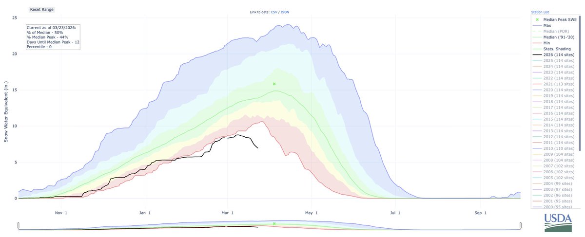
Okay, time for a NorCal fire weather update. First, good news: fire activity decreased overnight due to development of shallow marine layer along immediate coast, and cooler temps inland. Next 24 hours, fire activity will be strongly diurnal (i.e.,like normal).#CAwx#CAfire (1/n)
The bad news: this is as good as things are going to get for a while. This wknd, ridge builds back in once again from east, suppressing marine layer and bringing hot/dry conditions inland (though will *not* be as hot as last record heatwave over past week). #CAwx#CAfire (2/n)
Then, slightly disconcerting news. Remnant moisture & instability from former Hurricane #Genevieve will approach CA from south on Sunday. Uncertainty remains, but right now it appears there is a real risk of *another* dry lightning event in NorCal Sun/Mon. #CAwx#CAfire (3/n)
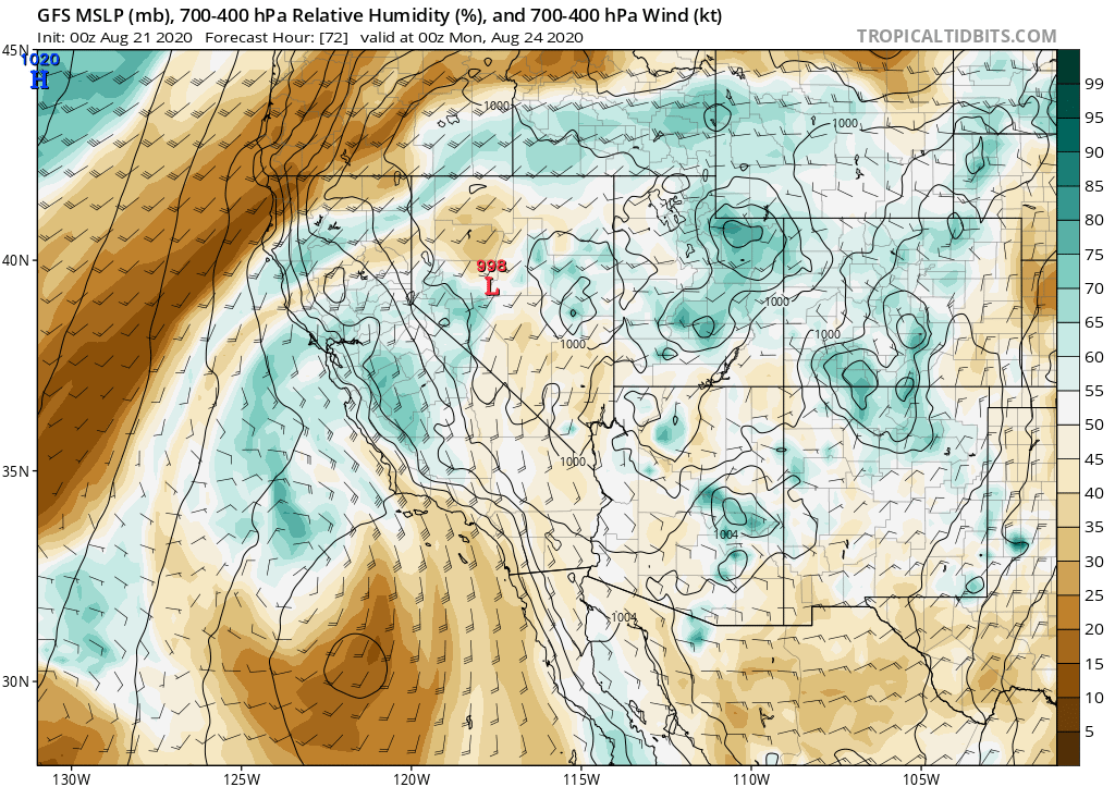
Right now, I'd put the odds of dry lightning somewhere in NorCal Sun-Mon somewhere around 50/50. So there's a 50% chance this fizzles altogether. (Fingers crossed). But these storms, if they occur, would produce little/no rain as well as lightning & gusty winds.#CAwx#CAfire(4/n)
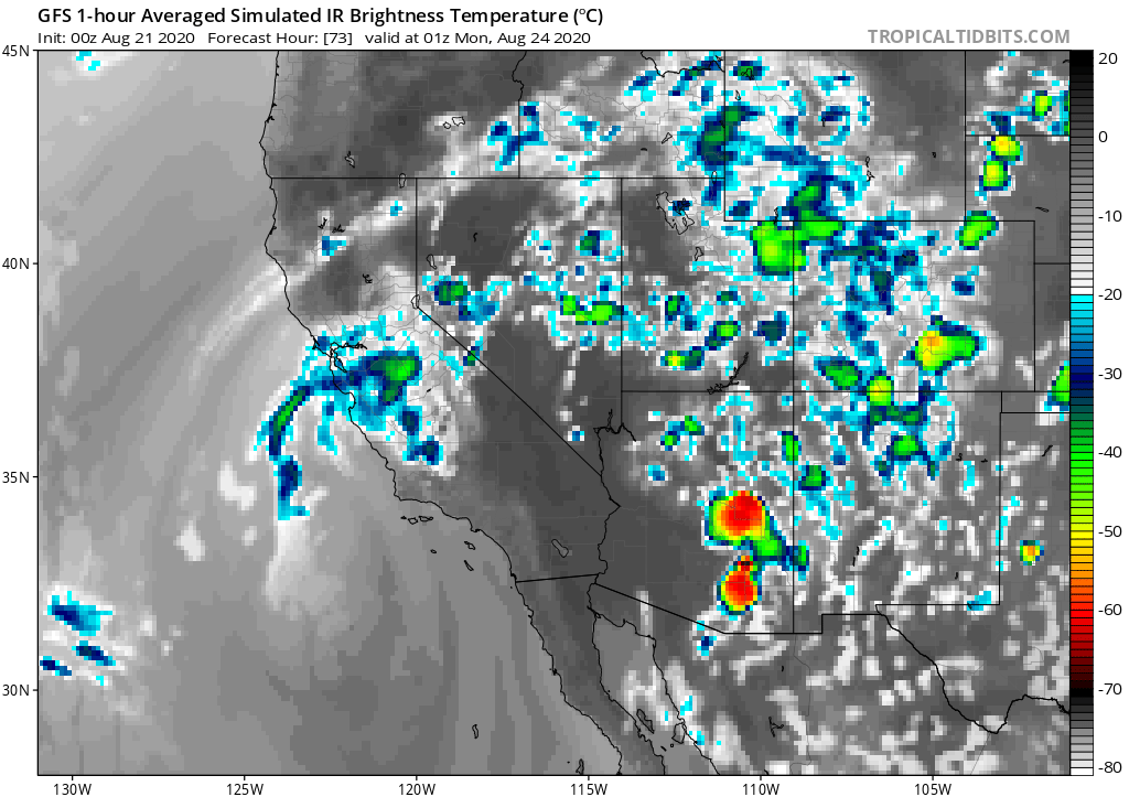
Given unprecedented number & extent of wildfires across NorCal & the firefighting resource drawdown already, this would be a very problematic weather outcome. But this kind of forecast is challenging, so follow @NWSBayArea & @NWSSacramento for details and updates. #CAwx#CAfire
• • •
Missing some Tweet in this thread? You can try to
force a refresh
For the first time since June in many parts of California and the broader Southwest, *cooler* than average temperatures can be expected for the next week, thanks in part to arrival of a *second* anomalously deep August low pressure system over NorCal Thu/Fri. #CAwx [1/4]
Another round of widespread rain & possible t-storms will occur in western WA & OR. In far NorCal, esp. northern mtns (Shasta region), some decent showers & t-storms are possible. Few showers/isolated thunder may reach farther south than last event--locally to I-80 corridor. #ORwx #WAwx #CAwx [2/4]
All of this will be fortuitous for fire season in western Washington and Oregon--mainly west of Cascades. While active fires will continue to east of Cascades, this may be season-ending precip (or close to it) for western WA and NW OR. #ORwx #WAwx [3/4]
For folks in Colorado wondering what the heck is going on with #Xcel's large-scale pre-emptive power line de-energization to avoid wildfire ignitions during high wind events, I wanted to share a some thoughts as a scientist who studies climate/weather/wildfire. #COwx [1/n]
The first utility-scale "Public Safety Power Shut-offs" (#PSPS) in response to fire risk of which I'm aware began in 2010s in California in response to catastrophic wildfire events in urban interface sparked by power infrastructure during extreme fire weather/wind events. [2/n]
Such fires occur when energized lines fall to ground or trees fall onto live wires (igniting vegetation). They tend to be preferentially dangerous precisely because they occur under "worst case" conditions, when weather favors rapid spread & fire suppression is ineffective. [3/n]
I wanted to reiterate some recent findings from our own research specifically addressing extreme #AtmosphericRiver storms in a warming climate.
1) CA will more extreme ARs in a warming climate, mainly (~80%) due water vapor increases. #CAwx #CAwater science.org/doi/10.1126/sc…
2) Extreme CA ARs in a warming climate will not only be more intense, but they may also have preferentially more southerly (deep subtropical) origins (like present one!). #CAwx #CAwater science.org/doi/10.1126/sc…
3) Integrated vapor transport, a measure of AR intensity, may increase at a "super Clausius-Clapeyron" rate (>>7%/C), especially over Southern California! #CAwx #CAwater science.org/doi/10.1126/sc…
Scientific institutions must create--and sustain--new kinds of roles so that researchers can provide the deep public engagement necessary to respond effectively to the escalating impacts of #climate change. The status quo isn't working. [Thread: 1/n] nature.com/articles/d4158…
My own role as a climate scientist-communicator is highly unusual in the academic world: I'm a practicing scientist who spends a large fraction (now over half) of my time engaging the public, and the rest of my time actually conducting research and writing papers. [2]
That engagement takes many forms. This year, I've given over 200 news interviews & worked with outlets behind the scenes to develop their coverage. I also work with state/federal agencies, brief members of state/national legislatures, and more. [3]
If you've been wondering why I've been somewhat less visible here, that's partly because of the "shifting winds" of social media. But also, I've been spending much effort scrambling to find some way to support my climate scientist-communicator role moving forward.
Thus far, I have not yet been successful in these efforts--& if nothing changes, the time left in my current role may unfortunately be limited. A great number of individuals & organizations have voiced support--and I'm hugely grateful for that!--but ultimately a large gap looms.
I'm still optimistic that something will arise in the coming months! But operating in this kind of highly public-facing climate science role unfortunately seems to fall between the cracks of existing institutions and funders. And ultimately, the status quo is not sustainable.
Some additional thoughts regarding the still strengthening #ElNiño and its implications for western U.S. hydroclimate during winter 2023-24. (Brief thread!) #CAwx #ORwx #WAwx #HIwx #CAwater #CAfire
International dynamical models ensemble is now unanimous in predicting strong to very strong #ElNiño event that will peak sometime this winter. This is a remarkably strong signal, so I'm reasonably confident that the oceanic signature of a strong EN will actually occur.
Additionally, there's good consensus that this #ElNiño event will be centered in the eastern Pacific basin, versus the central Pacific (i.e., this is not "#ElNiño Modoki"). High confidence in strong, east-based event signals increased likelihood of WUS hydroclimate impacts.