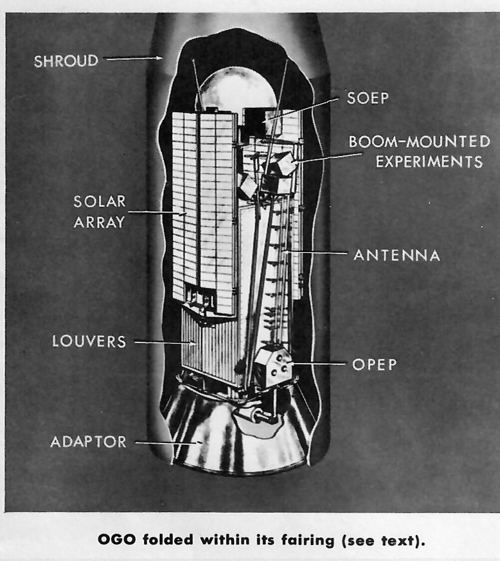
From NASA FACTS Vol II No. 13, some nice diagrams of OGO 1. First, OGO 1 in the Atlas Agena nose fairing
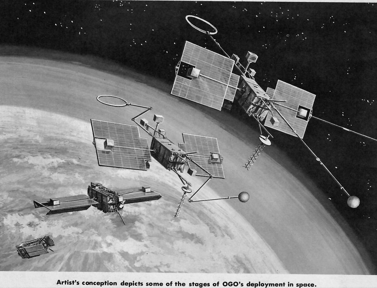
Next, OGO 1 at various stages of unpacking itself in orbit
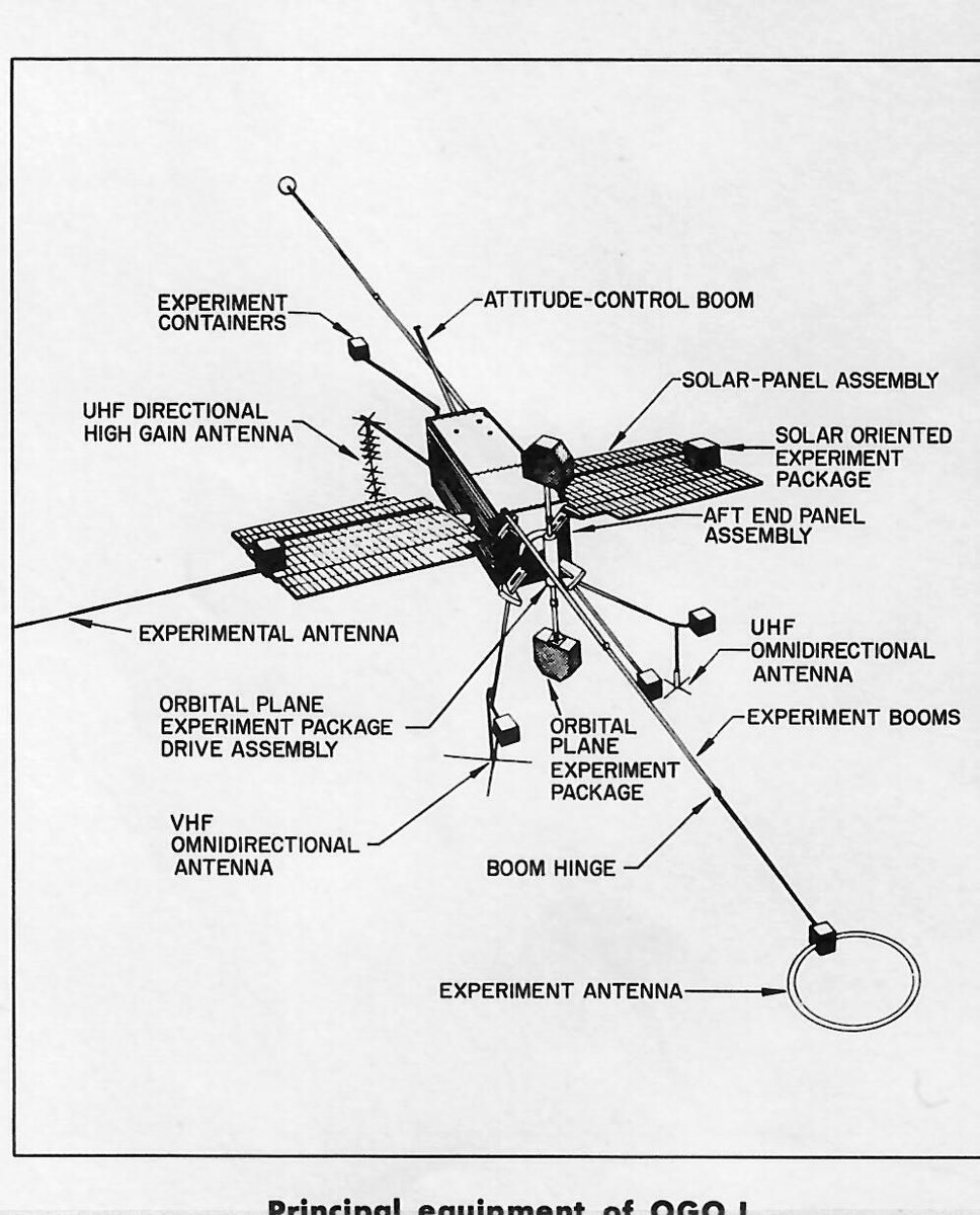
Finally, the satellite in all its glory with the instruments identified
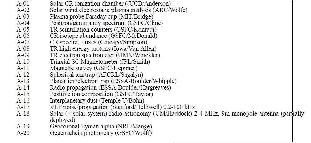
OGO-1 had a total of 20 experiments.
Six OGO satellites were launched from 1964 to 1969; three EGO (Eccentric Geophysical Observatory) in highly elliptical orbits and three POGO (Polar Orbiting Geophysical Observatory).
The satellites were known as OGO A to F before launch, and OGO I to VI after launch. They also had 'S' satellite codes in the systemused by GSFC starting in 1959:
S-49 OGO-A OGO I (EGO)
S-50 OGO-C OGO II (POGO)
S-49A OGO-B OGO III (EGO)
S-50A OGO-D OGO IV (POGO)
S-59 OGO-E OGO V (EGO)
S-60 OGO-F OGO VI (POGO)
OGO 1 is the last of the OGO payloads to remain in orbit. The rocket stages have also reentered, except perhaps for OGO 1's Agena rocket, Agena 6501 - it was never tracked after launch so has been lost since 1964.
• • •
Missing some Tweet in this thread? You can try to
force a refresh
Back from an intense week at the American Astronomical Society meeting. Much to report and much still to catch up on, but I'll start tonight with an update on the Starship flight
Starship Flight 7 was launched at 2237 UTC Jan 16 from Starbase, Texas, but failed to reach orbit. I will assign designation 2025-F01 to the launch. Super Heavy Booster 14 reached an apogee of 91 km, performed a boostback burn, and was caught by the launch tower.
Ship 33 separated from Booster 14 at 2m40s. There are three 'center' and three 'outboard' Raptor engines on Ship. At T+7:40 one center engine went out, followed at T+8:02 by a second center one and T+8:04 by the adjacent outboard one.
The planned trajectory of the North Korean satellite launch, as estimated by me based on debris warning areas, passes 500 km above the Okinawa region - higher than the International Space Station. The only landmass it goes directly over is the uninhabited island of Irisuna-jima.
It is possible that the second stage could shut down early, or that the yaw manuever prior to stage 2 ignition could go off course, so it is not completely *impossible* for debris from the launch to hit the Okinawa region. But it is very, very unlikely.
Thus, I consider Japanese goverment hyperventilation about the launch to be rather excessive.
Thanks to a tip from @martyn_williams I took a look at the warning areas for the upcoming (NET May 31) North Korean recon sat launch.
The map below shows the launch site, polygonal warning areas and (orange lines) my fit to the trajectories. (1/n)...
@martyn_williams I think the first and second warning areas correspond to first stage and nose fairing impact zones, and correspond to a -5650 x 150 km x 93.9 deg (sub)orbit (apogee not well constrained).
@martyn_williams Then the second stage makes a 'dog leg' yaw change to head southeast, firing at 1st stage apogee to a -5240 x 500 km x 75.7 deg orbit with impact east of the Phillipines. This trajectory has an apogee over 127.1E 26.1N.
On Tuesday at 2pm I'll be in room 205 for the "Space as an Environment" splinter session which will include an update on the issue of satellite constellations affecting ground based astronomy
That topic will be continued on Wed at 10am, room 201/202, for the "Space as an Environment" open house, where I'll be tabling and available for informal discussion about the satcon and other space env issues #AAS241
On Wed at 12.45 at the AAS reg desk I invite alumni of the SAO Astronomy Summer REU to join me for our traditional networking lunch expedition, actual eating venue still TBD #AAS241
The Japanese space agency JAXA is preparing to deploy 3 cubesats from the ISS.
The cubesats are stored in the J-SSOD #24 deployer, which was brought to ISS on Dragon CRS-26 and transferred internally to the Kibo module.
The Japanese JRMS robot arm has extracted J-SSOD #24 from the Kibo airlock and is now holding the deployer out against the direction of ISS motion so that the ejected sats will not recontact ISS.
The first sat to be ejected will be the 1U test satellite SS-1 (SuryaSat) from Surya University in Jakarta.
OK, it's Sunday night and I'm going to get technical on you.
You may be familiar with the Lagrange Points - specifically Sun-Earth L1 and L2 (SEL1 and SEL2), which are 1.5 million km towards noon and towards midnight respectively.
As the Earth goes round the Sun, L1 and L2 travel with it. So if you define a coordinate system which rotates around the Sun with the Earth, the L1 and L2 points are fixed in that system. One such system is GSE: Geocentric Solar Ecliptic.