01/60
THREAD
"How does Earth 'Manufacture' Land?
Some aspects of Natural History in the Indian Context"
The witticism “Buy Land. They ain't making any more of the stuff” is true, of course, if we look at “normal” time scales.
But it is not true on geological time scales!
THREAD
"How does Earth 'Manufacture' Land?
Some aspects of Natural History in the Indian Context"
The witticism “Buy Land. They ain't making any more of the stuff” is true, of course, if we look at “normal” time scales.
But it is not true on geological time scales!
02/60
This Thread is an attempt to answer a question which came to me when writing a previous Thread (Roopkund Skeletons – see my Pinned Tweet).
Did Earth have land and mountains and rivers and valleys on it ever since its birth 4.53 billion years ago?
This Thread is an attempt to answer a question which came to me when writing a previous Thread (Roopkund Skeletons – see my Pinned Tweet).
Did Earth have land and mountains and rivers and valleys on it ever since its birth 4.53 billion years ago?
03/60
The following is an attempt to explain what I was able to discover on the topic.
(Like my other Threads this one is also basically Notes which I made to understand the topic. I am not an expert. Do point out any mistakes when you find them).
The following is an attempt to explain what I was able to discover on the topic.
(Like my other Threads this one is also basically Notes which I made to understand the topic. I am not an expert. Do point out any mistakes when you find them).
04/60
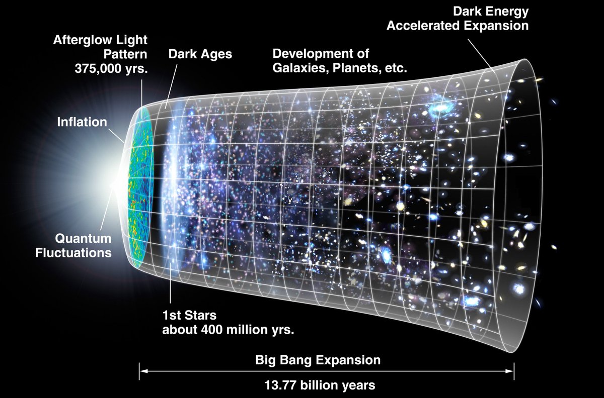
Here goes.
The Universe started with the Big Bang 13.8 billion years ago.
The consequent expansion of Energy and Space led to formation of particles.
Later these particles started clumping together to form simple atoms – Hydrogen and Helium.
(image from Wikipedia)
Here goes.
The Universe started with the Big Bang 13.8 billion years ago.
The consequent expansion of Energy and Space led to formation of particles.
Later these particles started clumping together to form simple atoms – Hydrogen and Helium.
(image from Wikipedia)
05/60
For half a billion years the Universe was dark.
But clumps of H and He were growing in size. They grew so massive that atoms in their interior, crushed by the pressure of the outer material, started fusing into heavier atoms.
For half a billion years the Universe was dark.
But clumps of H and He were growing in size. They grew so massive that atoms in their interior, crushed by the pressure of the outer material, started fusing into heavier atoms.
06/60
Fusion releases energy.
These were the first stars. There was Light!
As fusion proceeded, even heavier atoms, like iron, formed.
But star fuel ultimately runs out. If the star is large, it explodes – a “nova” or “supernova”.
Fusion releases energy.
These were the first stars. There was Light!
As fusion proceeded, even heavier atoms, like iron, formed.
But star fuel ultimately runs out. If the star is large, it explodes – a “nova” or “supernova”.
07/60
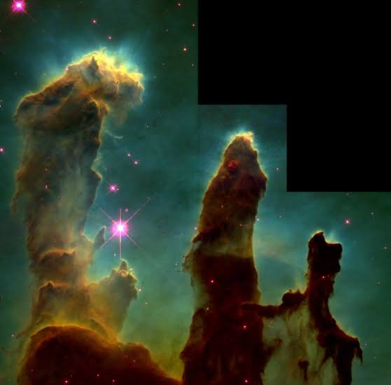
These explosions spew out matter into space forming dust and gas clouds called nebulae.
At some point nearby particles in a nebula start sticking together due to static electricity. They attract more particles.
("Pillars of Creation" in Eagle Nebula-from Wikipedia)
These explosions spew out matter into space forming dust and gas clouds called nebulae.
At some point nearby particles in a nebula start sticking together due to static electricity. They attract more particles.
("Pillars of Creation" in Eagle Nebula-from Wikipedia)
08/60
With more mass, gravity takes over. The nebula starts collapsing. A new star forms.
Left over dust and gas settle down as a “protoplanetary” disk revolving around the star. The material in this protoplanetary disk may gradually coalesce into planets.
With more mass, gravity takes over. The nebula starts collapsing. A new star forms.
Left over dust and gas settle down as a “protoplanetary” disk revolving around the star. The material in this protoplanetary disk may gradually coalesce into planets.

09/60
Our solar system also formed this way.
Inner planets - Mercury to Mars - were so hot that only iron and silicates could crystallise. These planets are rocky.
Jupiter, Saturn became gas giants.
Neptune, Uranus are ice giants where all gases crystallised.
Our solar system also formed this way.
Inner planets - Mercury to Mars - were so hot that only iron and silicates could crystallise. These planets are rocky.
Jupiter, Saturn became gas giants.
Neptune, Uranus are ice giants where all gases crystallised.
10/60
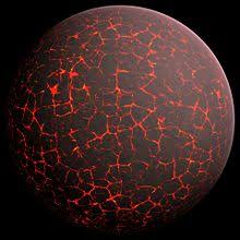
At its birth 4.53 billion years ago Earth was very hot.
This was partly due to energy present in the proto planetary disk.
Other reasons were radioactive decay, collisions with other objects (one of which formed the moon) and compression due to gravity.
At its birth 4.53 billion years ago Earth was very hot.
This was partly due to energy present in the proto planetary disk.
Other reasons were radioactive decay, collisions with other objects (one of which formed the moon) and compression due to gravity.
11/60
For the first half billion years after its birth Earth actually kept getting hotter because of these reasons.
A critical point came when its temperature exceeded the melting point of Iron (about 1500 deg C). This is called the “Iron Catastrophe”.
For the first half billion years after its birth Earth actually kept getting hotter because of these reasons.
A critical point came when its temperature exceeded the melting point of Iron (about 1500 deg C). This is called the “Iron Catastrophe”.
12/60
Molten Iron, Nickel and other dense elements started trickling downwards through the lighter molten silicates and other minerals.
Friction from the trickling down of molten metal added to the heat.
Molten Iron, Nickel and other dense elements started trickling downwards through the lighter molten silicates and other minerals.
Friction from the trickling down of molten metal added to the heat.
13/60
So the material on Earth got rearranged.
Heavier elements, like iron and nickel, wound up at Earth's centre – forming its Core. The lighter silicates surrounded the Core, forming the next layer - the “Mantle”.
So the material on Earth got rearranged.
Heavier elements, like iron and nickel, wound up at Earth's centre – forming its Core. The lighter silicates surrounded the Core, forming the next layer - the “Mantle”.
14/60
Today Earth's Core is a 3500 km thick ball of Iron and Nickel.
At its centre, about 6400 km down, temperature is ~6000 deg C.
But despite the high temperature Iron and Nickel in the Core are in solid form because of the pressure of the material above!
Today Earth's Core is a 3500 km thick ball of Iron and Nickel.
At its centre, about 6400 km down, temperature is ~6000 deg C.
But despite the high temperature Iron and Nickel in the Core are in solid form because of the pressure of the material above!
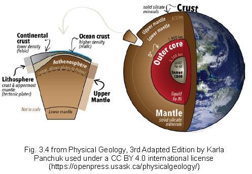
15/60
Above the Core, starting about 2900 km down and extending up almost to earth's surface, is the Mantle. The temperature at its base is about 3500 deg C.
It is composed of molten silicates with very high Magnesium and Iron content - “Ultra Mafic” rock.
Above the Core, starting about 2900 km down and extending up almost to earth's surface, is the Mantle. The temperature at its base is about 3500 deg C.
It is composed of molten silicates with very high Magnesium and Iron content - “Ultra Mafic” rock.
16/60
The upper layer of the Mantle, the Aesthenosphere, is cooler, and consists mostly of solid rock.
But convection from inner layers means that molten rock also comes through. Asthenosphere is therefore fluid, and not very strong.
The upper layer of the Mantle, the Aesthenosphere, is cooler, and consists mostly of solid rock.
But convection from inner layers means that molten rock also comes through. Asthenosphere is therefore fluid, and not very strong.
17/60
Above the Mantle is the “Crust”. It consists of solid rock, about 15 km thick on average, but much thicker in places. Temperature at its base is about 1000 deg C. The Crust floats on the Aesthenosphere below.
Above the Mantle is the “Crust”. It consists of solid rock, about 15 km thick on average, but much thicker in places. Temperature at its base is about 1000 deg C. The Crust floats on the Aesthenosphere below.
18/60
The outermost Mantle and the Asthenosphere below it are together called the Lithosphere.
The Crust is not a single piece, but multiple pieces. These pieces are called “tectonic plates”.
The outermost Mantle and the Asthenosphere below it are together called the Lithosphere.
The Crust is not a single piece, but multiple pieces. These pieces are called “tectonic plates”.
19/60
Pieces of the Crust with more silicates (“Felsic”), are lighter and “ride higher” while floating. They form the Crust under land.
Other pieces, with more Magnesium and Iron (“Mafic”), are denser and “sink” lower. They form the Crust below oceans.
Pieces of the Crust with more silicates (“Felsic”), are lighter and “ride higher” while floating. They form the Crust under land.
Other pieces, with more Magnesium and Iron (“Mafic”), are denser and “sink” lower. They form the Crust below oceans.
20/60
In 1911 Alfred Wegener observed that many different continents have similar fossils.
He proposed that since these organisms could not have crossed oceans, the landmasses where they are found must have been joined at one time, and then moved apart.
In 1911 Alfred Wegener observed that many different continents have similar fossils.
He proposed that since these organisms could not have crossed oceans, the landmasses where they are found must have been joined at one time, and then moved apart.
21/60
The idea did not find acceptance at first. But over time more evidence for Wegener's hypothesis emerged.
One of these was related to earth's magnetism.
The idea did not find acceptance at first. But over time more evidence for Wegener's hypothesis emerged.
One of these was related to earth's magnetism.
22/60
Free Haematite (Fe3O4 - Iron Oxide) particles on earth's surface, being magnetic, point north.
But haematite embedded in rocks of different ages in different continents over last few hundred million years, points in various different directions.
Free Haematite (Fe3O4 - Iron Oxide) particles on earth's surface, being magnetic, point north.
But haematite embedded in rocks of different ages in different continents over last few hundred million years, points in various different directions.
23/60
Since north pole has stayed stationary over this time, the only explanation is that haematite was indeed pointing north when it got embedded in rock, but that subsequently the landmass itself moved and changed direction.
Since north pole has stayed stationary over this time, the only explanation is that haematite was indeed pointing north when it got embedded in rock, but that subsequently the landmass itself moved and changed direction.
24/60
By studying the orientation of haematite particles it is actually possible to deduce what latitude the underlying landmass was at, when the particle got embedded in rock.
This evidence led to the theory of “Plate Tectonics” being accepted by the 1960s.
By studying the orientation of haematite particles it is actually possible to deduce what latitude the underlying landmass was at, when the particle got embedded in rock.
This evidence led to the theory of “Plate Tectonics” being accepted by the 1960s.
25/60
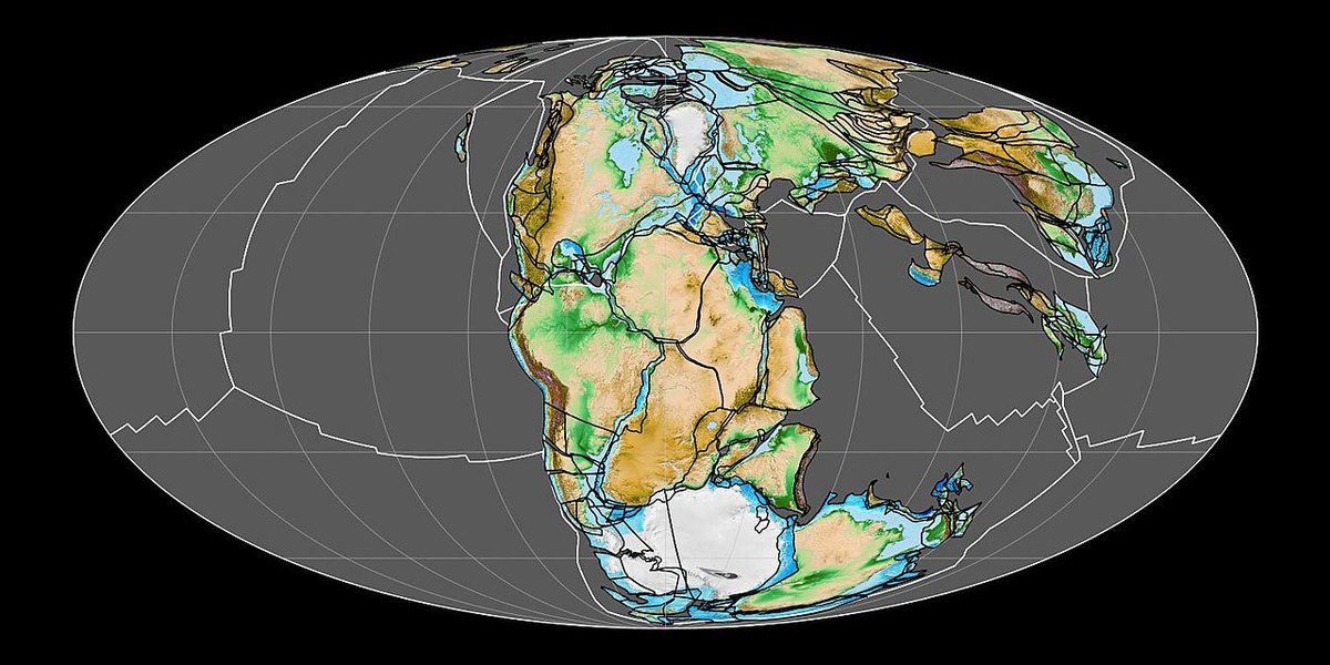
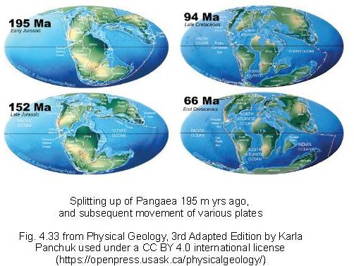
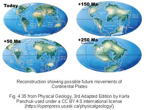
The accepted wisdom now is that about 150 - 200 m years ago there was a super continent - Pangaea.
Then the Plates started moving and Pangaea started to break up.
After 200 million years of drift the Plates reached their present positions.
The accepted wisdom now is that about 150 - 200 m years ago there was a super continent - Pangaea.
Then the Plates started moving and Pangaea started to break up.
After 200 million years of drift the Plates reached their present positions.
26/60
200 m years ago, Africa split from Asia, N America from S America, Atlantic began to open up between N Africa and N America and India split from Antarctica. S America later split from Africa and N America from Europe. India moved north.
200 m years ago, Africa split from Asia, N America from S America, Atlantic began to open up between N Africa and N America and India split from Antarctica. S America later split from Africa and N America from Europe. India moved north.
27/60
Africa separated from S America and Europe from N America 80 m years ago.
Australia separated from Antarctica and India collided with Asia 50 m years ago.
(For context, note that 200 m yrs is a mere blip compared to 4.53 b yrs, the age of the earth).
Africa separated from S America and Europe from N America 80 m years ago.
Australia separated from Antarctica and India collided with Asia 50 m years ago.
(For context, note that 200 m yrs is a mere blip compared to 4.53 b yrs, the age of the earth).
28/60
This drifting of Plates will continue into the future.
Perhaps 250 million years from now, the continents will be together again.
Many similar cycles of separation and merger (called Wilson Cycles – after J Tuzo Wilson) were there before Pangaea.
This drifting of Plates will continue into the future.
Perhaps 250 million years from now, the continents will be together again.
Many similar cycles of separation and merger (called Wilson Cycles – after J Tuzo Wilson) were there before Pangaea.
29/60
But why did a super continent like Pangaea break up?
Wilson proposed that breakup started at points where hot Magma from Earth's Mantle rises to the Crust in a “Plume”. This weakens the Crust and leads to formation of separate Tectonic Plates.
But why did a super continent like Pangaea break up?
Wilson proposed that breakup started at points where hot Magma from Earth's Mantle rises to the Crust in a “Plume”. This weakens the Crust and leads to formation of separate Tectonic Plates.
30/60
Different Tectonic Plates move in different directions.
At places different Plates diverge from each other. At other places they collide with each other. At yet other places they slide past each other.
Different Tectonic Plates move in different directions.
At places different Plates diverge from each other. At other places they collide with each other. At yet other places they slide past each other.
31/60
DIVERGING PLATES:
Separation of Plates probably begins due to one or more “Mantle Plumes” which weaken the Crust, usually under the ocean.
The Crust ruptures and Plates start drifting apart. At the rupture magma emerges, cools, and forms new Crust.
DIVERGING PLATES:
Separation of Plates probably begins due to one or more “Mantle Plumes” which weaken the Crust, usually under the ocean.
The Crust ruptures and Plates start drifting apart. At the rupture magma emerges, cools, and forms new Crust.
32/60
COLLIDING PLATES:
When two Plates collide, what happens depends on the relative density of the Plates:
COLLIDING PLATES:
When two Plates collide, what happens depends on the relative density of the Plates:
33/60
If both colliding plates are Oceanic Plates then the denser of the two (typically the older Plate), slips (subducts) under the newer, lighter Plate.
This forms trenches. Magma can emerge from these trenches, cool, and form arcs of volcanic islands.
If both colliding plates are Oceanic Plates then the denser of the two (typically the older Plate), slips (subducts) under the newer, lighter Plate.
This forms trenches. Magma can emerge from these trenches, cool, and form arcs of volcanic islands.

34/60
In a Oceanic Plate-Continental Plate collision the heavy Oceanic Plate subducts below the lighter Continental Plate, forming wedges of Land at the boundary.
Magma from the Mantle wells up in the subduction area and forms mountain chains with volcanoes.
In a Oceanic Plate-Continental Plate collision the heavy Oceanic Plate subducts below the lighter Continental Plate, forming wedges of Land at the boundary.
Magma from the Mantle wells up in the subduction area and forms mountain chains with volcanoes.
35/60
If two Continental Plates collide, Oceanic Crust around the heavier Plate subducts but Land Crust does not (it is light).
Continental rocks at the boundary get crushed and pile up, forming high “Fold Mountains” – Himalayas, Rockies, Andes are examples.
If two Continental Plates collide, Oceanic Crust around the heavier Plate subducts but Land Crust does not (it is light).
Continental rocks at the boundary get crushed and pile up, forming high “Fold Mountains” – Himalayas, Rockies, Andes are examples.
36/60
PLATES SLIDING BY EACH OTHER:
When this happens there are some areas of collision and other areas of divergence.
Faults develop along Plate boundaries, sometimes over long distances. San Andreas Fault on the west coast of the US is an example.
PLATES SLIDING BY EACH OTHER:
When this happens there are some areas of collision and other areas of divergence.
Faults develop along Plate boundaries, sometimes over long distances. San Andreas Fault on the west coast of the US is an example.
37/60
Let us now look at the building blocks of Crustal Plates – rocks.
There is a “Rock Cycle” at work, driven by 2 forces:
- Heat in earth's Mantle and Core causing material to move.
- Effect of water and air on earth's surface – driven by the Sun.
Let us now look at the building blocks of Crustal Plates – rocks.
There is a “Rock Cycle” at work, driven by 2 forces:
- Heat in earth's Mantle and Core causing material to move.
- Effect of water and air on earth's surface – driven by the Sun.
38/60
The Earth's interior is gradually cooling down. When it cools enough so that movement of material inside the Earth stops, or if the atmosphere thickness reduces, or if liquid water is not available, the Rock Cycle will stop.
The Earth's interior is gradually cooling down. When it cools enough so that movement of material inside the Earth stops, or if the atmosphere thickness reduces, or if liquid water is not available, the Rock Cycle will stop.
39/60
What is ROCK CYCLE?
Magma from the Mantle, welling up or thrown up in volcanic eruptions, cools, and forms what are called “Igneous” rocks. Granite is an example.
Igneous rocks may be below the surface (“intrusive rock”) or above (“extrusive rock”).
What is ROCK CYCLE?
Magma from the Mantle, welling up or thrown up in volcanic eruptions, cools, and forms what are called “Igneous” rocks. Granite is an example.
Igneous rocks may be below the surface (“intrusive rock”) or above (“extrusive rock”).

40/60
These rocks get uplifted due to tectonic activity and accretion into “outcrops” and mountains.
They then undergo “weathering” due to chemical and physical processes such as those caused by water and wind. This breaks them up over millennia.
These rocks get uplifted due to tectonic activity and accretion into “outcrops” and mountains.
They then undergo “weathering” due to chemical and physical processes such as those caused by water and wind. This breaks them up over millennia.
41/60
The byproducts of weathering are transported by wind and water and get deposited as “sediments”.
Over time these deposit thicken up to hundreds of metres. Compression can then lead to formation of “Sedimentary Rocks”. Sandstone is an example.
The byproducts of weathering are transported by wind and water and get deposited as “sediments”.
Over time these deposit thicken up to hundreds of metres. Compression can then lead to formation of “Sedimentary Rocks”. Sandstone is an example.
42/60
Sedimentary rock buried deep inside, can be subjected to temperature and pressure that transform (metamorphose) it into “Metamorphic Rock”. Marble, Gneiss and Schist are examples.
If buried deep enough, metamorphic rock melts, completing the Rock Cycle
Sedimentary rock buried deep inside, can be subjected to temperature and pressure that transform (metamorphose) it into “Metamorphic Rock”. Marble, Gneiss and Schist are examples.
If buried deep enough, metamorphic rock melts, completing the Rock Cycle
43/60
How does all this help explain the formation of land on earth?
To answer this it is useful to know that some parts of today's continents are older and more stable than other parts, which are more mobile.
The older, stable parts are called “Cratons”.
How does all this help explain the formation of land on earth?
To answer this it is useful to know that some parts of today's continents are older and more stable than other parts, which are more mobile.
The older, stable parts are called “Cratons”.
44/60
Primordial Earth had higher heat flow than today. It was more seismically active and had a thinner Crust. The Mantle was less viscous.
Nuclei of “proto cratons” may have formed on primordial earth at spots where more buoyant rocks dominated.
Primordial Earth had higher heat flow than today. It was more seismically active and had a thinner Crust. The Mantle was less viscous.
Nuclei of “proto cratons” may have formed on primordial earth at spots where more buoyant rocks dominated.
45/60
Over time, molten rock, subduction of heavier Crust below lighter and accretion of material from volcanic arcs added material, thickening the Crust below the proto cratons.
The roots of today's Cratons extend all the way to the Lithosphere.
Over time, molten rock, subduction of heavier Crust below lighter and accretion of material from volcanic arcs added material, thickening the Crust below the proto cratons.
The roots of today's Cratons extend all the way to the Lithosphere.
46/60
The basement of almost all Cratons is igneous rocks, such as Gneiss and Granite. If the craton's basement extends above the Earth's surface it is called a “Shield”.
If it is below the surface and overlain with sediments it is called a “Platform”.
The basement of almost all Cratons is igneous rocks, such as Gneiss and Granite. If the craton's basement extends above the Earth's surface it is called a “Shield”.
If it is below the surface and overlain with sediments it is called a “Platform”.
47/60
Over time cratons collided, diverged and sheared past one another forming hills, rift valleys and faults in the interior of continents.
Cratons are relatively stable now and do not move much with respect to each other.
Over time cratons collided, diverged and sheared past one another forming hills, rift valleys and faults in the interior of continents.
Cratons are relatively stable now and do not move much with respect to each other.
48/60
The following cratons make up India's landmass:
Western Dharwar craton
Eastern Dharwar craton
Bastar craton
Singhbhum craton
Bundelkhand craton
Aravalli craton
Meghalaya craton
Almost all cratons have basements of Gneiss and Granite.
(Map from bit.ly/3kqP7Vu)
The following cratons make up India's landmass:
Western Dharwar craton
Eastern Dharwar craton
Bastar craton
Singhbhum craton
Bundelkhand craton
Aravalli craton
Meghalaya craton
Almost all cratons have basements of Gneiss and Granite.
(Map from bit.ly/3kqP7Vu)

49/60
Where cratons collide, Fold Mountains can form. An example is the Aravalli Range, formed by the collision of Aravalli and Bundelkhand cratons. These once high mountains have been reduced to their present size due to weathering.
Where cratons collide, Fold Mountains can form. An example is the Aravalli Range, formed by the collision of Aravalli and Bundelkhand cratons. These once high mountains have been reduced to their present size due to weathering.
50/60
Where cratons drift apart there can be Rift Valleys.
Godavari Rift Valley between Dharwar and Bastar cratons and Mahanadi Rift Valley between Bastar and Singhbhum cratons are examples. These valleys accumulate sedimentary deposits with time.
Where cratons drift apart there can be Rift Valleys.
Godavari Rift Valley between Dharwar and Bastar cratons and Mahanadi Rift Valley between Bastar and Singhbhum cratons are examples. These valleys accumulate sedimentary deposits with time.
51/60
At the southern tip of the Indian peninsula is the Southern Mobile Belt or the Southern Granulite Terrane.
It contains land formed by accretion and has rocks ranging from as old as 2.5 billion years old, to 0.6 billion years old.
At the southern tip of the Indian peninsula is the Southern Mobile Belt or the Southern Granulite Terrane.
It contains land formed by accretion and has rocks ranging from as old as 2.5 billion years old, to 0.6 billion years old.
52/60
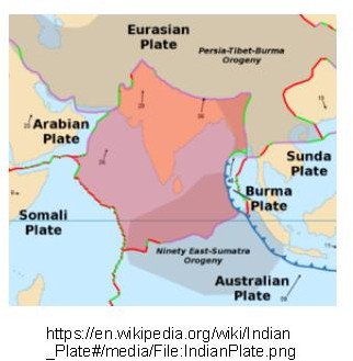
In the north are the Himalayas – the relatively young fold mountains which formed when Indian Plate crashed into Asia 50 million years ago.
In the shadow of the Himalayas lie the sedimentary Alluvial deposits of the Gangetic Plain and
In the north are the Himalayas – the relatively young fold mountains which formed when Indian Plate crashed into Asia 50 million years ago.
In the shadow of the Himalayas lie the sedimentary Alluvial deposits of the Gangetic Plain and
53/60
Almost 500000 sq km of the western Deccan plateau comprises of the Deccan Traps. They are named for their stair like appearance (“trappa” in Swedish means stairs) and are one of earth's largest volcanic features.
Almost 500000 sq km of the western Deccan plateau comprises of the Deccan Traps. They are named for their stair like appearance (“trappa” in Swedish means stairs) and are one of earth's largest volcanic features.
54/60
The Traps are igneous rock left by cooling of volcanic magma released in prolonged eruptions about 60 million years ago.
The eruptions lasted for perhaps 30,000 years. Sulphur dioxide released in these eruptions dropped earth's temperature by 2 deg C.
The Traps are igneous rock left by cooling of volcanic magma released in prolonged eruptions about 60 million years ago.
The eruptions lasted for perhaps 30,000 years. Sulphur dioxide released in these eruptions dropped earth's temperature by 2 deg C.
55/60
One hypothesis for explaining these eruptions is that as the Indian Plate was floating towards Asia, it passed over a Mantle Plume somewhere near Reunion Island about 60 m years ago. The Plume caused the Crust to weaken and led to the eruptions.
One hypothesis for explaining these eruptions is that as the Indian Plate was floating towards Asia, it passed over a Mantle Plume somewhere near Reunion Island about 60 m years ago. The Plume caused the Crust to weaken and led to the eruptions.
56/60
The Western Ghats are thought to have formed when India broke off from Pangaea. The west coast came into existence later, when Madagascar broke off.
Today the Ghats are a biodiversity hot spot, and house species not found anywhere else in the world.
The Western Ghats are thought to have formed when India broke off from Pangaea. The west coast came into existence later, when Madagascar broke off.
Today the Ghats are a biodiversity hot spot, and house species not found anywhere else in the world.
57/60
Unlike the Western Ghats the Eastern Ghats are a discontinuous set of mountains, separated by major river valleys.
Unlike the Western Ghats the Eastern Ghats are a discontinuous set of mountains, separated by major river valleys.
58/60
The power of geological forces is also evident in the seas that surround India. This wonderful illustration of the “Fans” of the Ganga and the Indus by @rajbhagatt show how far under the sea the effect of these mighty rivers extends.
The power of geological forces is also evident in the seas that surround India. This wonderful illustration of the “Fans” of the Ganga and the Indus by @rajbhagatt show how far under the sea the effect of these mighty rivers extends.
https://twitter.com/rajbhagatt/status/1274315178415276032?s=20
I hope you are as by this information as I am. This learning exercise gave me new insight and appreciation for illustrations such as this one of Nallamalla Hills in the Deccan made by @Macharlazz. I hope you will also indulge your curiosity.
https://twitter.com/Macharlazz/status/1299356393703694339?s=20
60/60
Thanks to @KarlaPanchuk for the excellent Physical Geology, 3rd Adapted Edition by Karla Panchuk used under a CC BY 4.0 international license and to @UsaskGeoSci for making it available online at openpress.usask.ca/physicalgeolog…
Thanks to @KarlaPanchuk for the excellent Physical Geology, 3rd Adapted Edition by Karla Panchuk used under a CC BY 4.0 international license and to @UsaskGeoSci for making it available online at openpress.usask.ca/physicalgeolog…
@threadreaderapp unroll
• • •
Missing some Tweet in this thread? You can try to
force a refresh