Jonathan McDowell Profile picture
Sep 26, 2020 12 tweets 3 min read Read on X
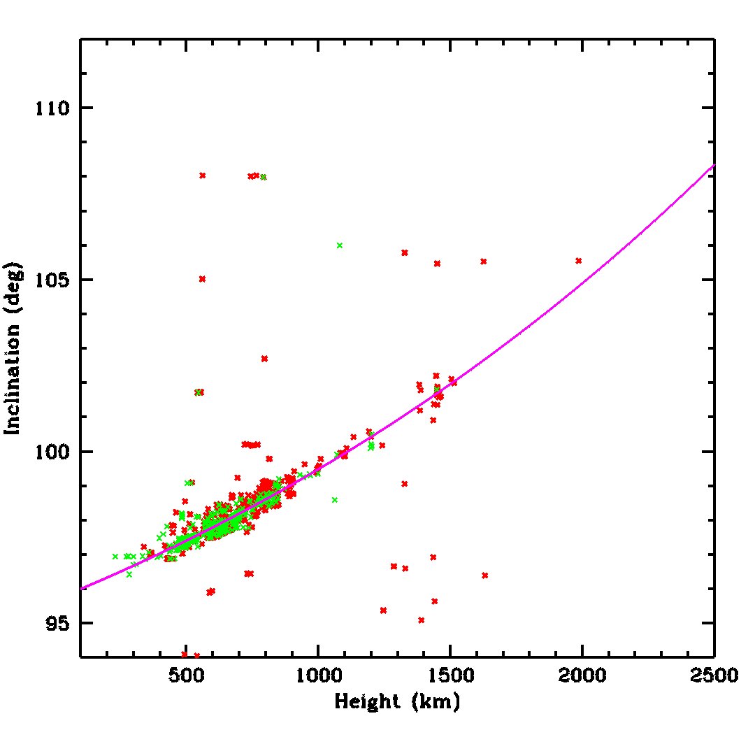
Here are all the actual satellites in orbit in this range of heights and inclinations (green = working, red = dead). See how they are almost all right on the magenta SSO line. They are also almost all below 1000 km. The rest of the diagram is really empty of satellites!
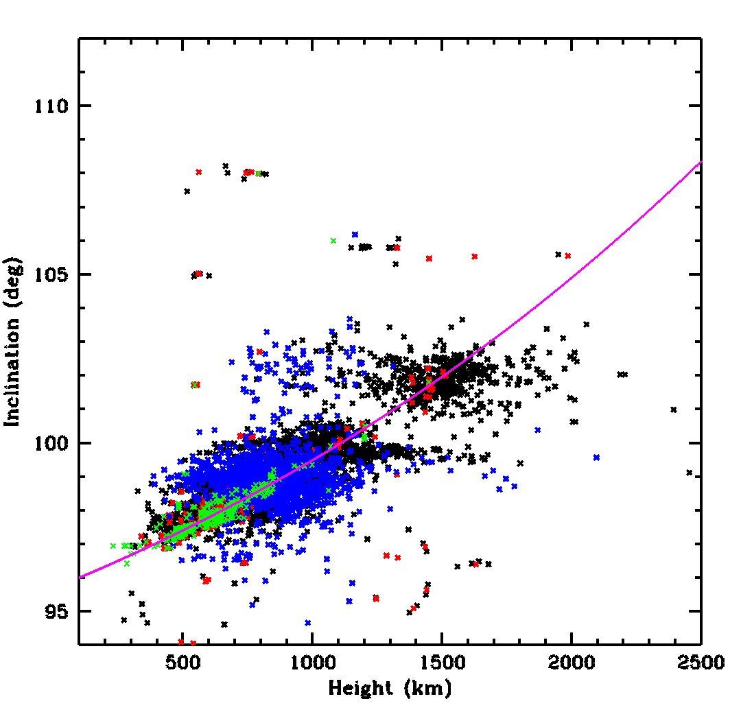
Now let's add in orbital debris. Generic orbital debris in black; debris from the 2007 Chinese antisatellite test in blue. You couldn't have picked a much worse region of orbital parameter space to make a big debris cloud.
Finally, here is a zoom in on the busiest part of SSO, omitting the debris
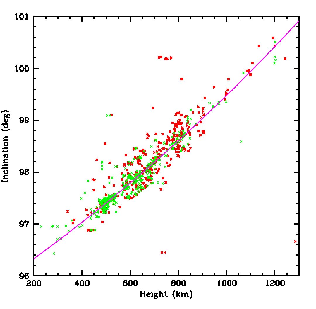
And here's the same zoom in region showing debris that is NOT from the Chinese ASAT, so they are not the only culprits. I think this debris is mostly from US rocket stages that disintegrated accidentally, but I'll have to dig deeper to check that.
And for completeness, the debris that is from the Chinese ASAT, in the same zoomed-in part of orbital parameter space
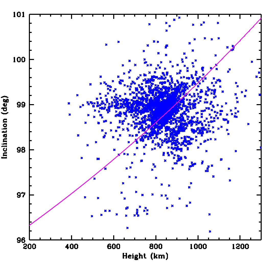
There are 2679 debris pieces in the plot from the ASAT. There are a comparable number, 2609 pieces, from other launches, all accidental breakups. Half of those pieces are from just 6 breakups:
455 pieces from the US NOAA 16 battery explosion in 2015
273 from the breakup of US rocket stage Agena 6231 in 1970
221 from the US DMSP F-13 battery explosiion in 2015
188 from the Chinese CZ-4B Y1 rocket stage in 2000
183 from Delta 111, 1991
149 from Delta 139, 1981
The Delta, Agena and CZ-4B stages are thought to have broken up due to residual propellant igniting many years after the stages were abandoned in orbit.
NOAA 16 and DMSP F-13 were respectively civil and military versions of the same weather satellite design which had a generic problem with exploding batteries (they are not the only cases, just the worst in SSO).
As a comparison I thought I'd show a different (but comparable size) region of parameter space, away from SSO. This is much emptier of active satellites except for the 51.6 deg inclination slot used by the ISS and related objects
And more equatorial regions of LEO are almost deserted of objects
(Of course on every orbit the polar orbit satellites pass through the space occupied by the more equatorial ones - don't be misled into thinking that the orbit parameter space is the same as physical space)

• • •

Missing some Tweet in this thread? You can try to force a refresh
 

Keep Current with Jonathan McDowell

Jonathan McDowell Profile picture

Stay in touch and get notified when new unrolls are available from this author!

Read all threads

This Thread may be Removed Anytime!

PDF

Twitter may remove this content at anytime! Save it as PDF for later use!

Try unrolling a thread yourself!

how to unroll video
  1. Follow @ThreadReaderApp to mention us!

  2. From a Twitter thread mention us with a keyword "unroll"
@threadreaderapp unroll

Practice here first or read more on our help page!

More from @planet4589

May 29, 2023
The planned trajectory of the North Korean satellite launch, as estimated by me based on debris warning areas, passes 500 km above the Okinawa region - higher than the International Space Station. The only landmass it goes directly over is the uninhabited island of Irisuna-jima. Image
It is possible that the second stage could shut down early, or that the yaw manuever prior to stage 2 ignition could go off course, so it is not completely *impossible* for debris from the launch to hit the Okinawa region. But it is very, very unlikely.
Thus, I consider Japanese goverment hyperventilation about the launch to be rather excessive.
Read 4 tweets
May 29, 2023
Thanks to a tip from @martyn_williams I took a look at the warning areas for the upcoming (NET May 31) North Korean recon sat launch.
The map below shows the launch site, polygonal warning areas and (orange lines) my fit to the trajectories. (1/n)... Image
@martyn_williams I think the first and second warning areas correspond to first stage and nose fairing impact zones, and correspond to a -5650 x 150 km x 93.9 deg (sub)orbit (apogee not well constrained).
@martyn_williams Then the second stage makes a 'dog leg' yaw change to head southeast, firing at 1st stage apogee to a -5240 x 500 km x 75.7 deg orbit with impact east of the Phillipines. This trajectory has an apogee over 127.1E 26.1N.
Read 5 tweets
Jan 8, 2023
On Tuesday at 2pm I'll be in room 205 for the "Space as an Environment" splinter session which will include an update on the issue of satellite constellations affecting ground based astronomy
That topic will be continued on Wed at 10am, room 201/202, for the "Space as an Environment" open house, where I'll be tabling and available for informal discussion about the satcon and other space env issues #AAS241
On Wed at 12.45 at the AAS reg desk I invite alumni of the SAO Astronomy Summer REU to join me for our traditional networking lunch expedition, actual eating venue still TBD #AAS241
Read 4 tweets
Jan 6, 2023
The Japanese space agency JAXA is preparing to deploy 3 cubesats from the ISS.
The cubesats are stored in the J-SSOD #24 deployer, which was brought to ISS on Dragon CRS-26 and transferred internally to the Kibo module.
The Japanese JRMS robot arm has extracted J-SSOD #24 from the Kibo airlock and is now holding the deployer out against the direction of ISS motion so that the ejected sats will not recontact ISS.
The first sat to be ejected will be the 1U test satellite SS-1 (SuryaSat) from Surya University in Jakarta.
Read 5 tweets
Dec 19, 2022
OK, it's Sunday night and I'm going to get technical on you.
You may be familiar with the Lagrange Points - specifically Sun-Earth L1 and L2 (SEL1 and SEL2), which are 1.5 million km towards noon and towards midnight respectively.
As the Earth goes round the Sun, L1 and L2 travel with it. So if you define a coordinate system which rotates around the Sun with the Earth, the L1 and L2 points are fixed in that system. One such system is GSE: Geocentric Solar Ecliptic.
Read 15 tweets
Dec 16, 2022
LAUNCH of Falcon 9 at 2248 UTC Dec 16 from Cape Canaveral LC40 with two O3b-mPOWER communications satellites
20 first-gen O3b satellites were launched to 8000 km equatorial orbits in 2013 to 2019. They had a mass of 700 kg.
The new O3b mPOWER sats are Boeing 702X satellites with a . mass of 1700 kg each. I believe their size is around 1.5 x 3.0 x 3.0 m with about 27m solar panel span
Correction, O3b-mPOWER mass may be 2050 kg each, based on info in @SpaceflightNow 's coverage
Read 6 tweets

Did Thread Reader help you today?

Support us! We are indie developers!


This site is made by just two indie developers on a laptop doing marketing, support and development! Read more about the story.

Become a Premium Member ($3/month or $30/year) and get exclusive features!

Become Premium

Don't want to be a Premium member but still want to support us?

Make a small donation by buying us coffee ($5) or help with server cost ($10)

Donate via Paypal

Or Donate anonymously using crypto!

Ethereum

0xfe58350B80634f60Fa6Dc149a72b4DFbc17D341E copy

Bitcoin

3ATGMxNzCUFzxpMCHL5sWSt4DVtS8UqXpi copy

Thank you for your support!

Follow Us!

:(